Description
Transcription
Page running head (top centre, above rule):
LA-ICP-MS study of malachite from copper deposits in the Rosen ore field, Burgas ore district, SE Bulgaria
Section heading (upper-left column):
GEOLOGICAL SETTING
Body text — left column (full, as printed):
The formation of copper ore deposits in the region of SE Bulgaria is associated with four Late Cretaceous volcano-plutonic centers grouped in the four ore fields of the same names: Rosen (vein copper-molybdenum), Varli Bryag (vein copper), Zidarovo and Bakadzhik (both vein copper-polymetallic). The main rock varieties of the plutons are syenites and monzonites, which intruded into trachyandesite and andesite volcanic rocks. Numerous dykes of the same composition cut across these rocks. The ore veins are of hydrothermal hypabyssal origin (Bogdanov, 1987; Popov et al., 1993).
The differences in the mineral associations between ore fields in the Burgas ore region have been the subject of research by Vasilev (1960), Vasilev and Stanasheva-Vasileva (1972), Todorov (1982), and others. The Rosen ore field deposits are of the copper-molybdenum (cobalt-bearing) type. Their mineralization is predominantly chalcopyrite with less molybdenite ore, magnetite, and cobalt-bearing pyrite (Bogdanov, 1987). Chalcopyrite-pyrite mineralization and specularite are specific features of the Varli Bryag ore field deposits. Sphalerite-galena ore in non-industrial quantities and bismuth-containing sulfides and sulfosalts are included in their mineral association. The Zidarovo and Bakadzhik ore fields are copper-polymetallic with gold-silver,
Body text — right column (continuation; full as printed on this page):
bismuth, and galena-sphalerite mineralization. Molybdenum and cobalt-bearing pyrite mineralization are not typical here (Bogdanov, 1987).
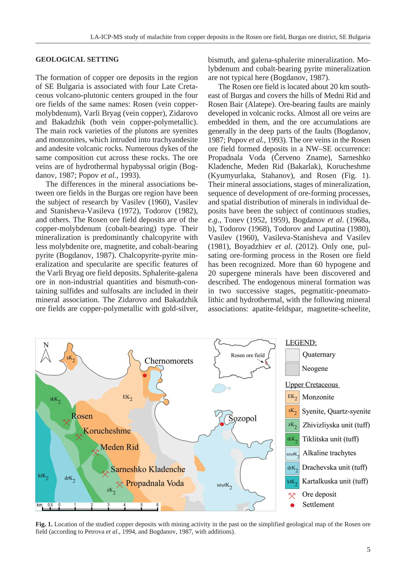
The Rosen ore field is located about 20 km southeast of Burgas and covers the hills of Medni Rid and Rosen Bair (Alatepe). Ore-bearing faults are mainly developed in volcanic rocks. Almost all ore veins are embedded in them, and the ore accumulations are generally in the deep parts of the faults (Bogdanov, 1987; Popov et al., 1993). The ore veins in the Rosen ore field formed deposits in a NW–SE occurrence: Propadnala Voda (Červeno Zname), Sarneshko Kladenche, Meden Rid (Bakarlak), Korucheshme (Kyumyurlaka, Stahanov), and Rosen (Fig. 1). Their mineral associations, stages of mineralization, sequence of development of ore-forming processes, and spatial distribution of minerals in individual deposits have been the subject of continuous studies, e.g., Tonev (1952, 1959), Bogdanov et al. (1968a, b), Todorov (1968), Todorov and Laputina (1980), Vasilev (1960), Vasileva-Stanisheva and Vasilev (1981), Boyadzhiev et al. (2012). Only one, pulsating ore-forming process in the Rosen ore field has been recognized. More than 60 hypogene and 20 supergene minerals have been discovered and described. The endogenous mineral formation was in two successive stages, pegmatitic-pneumatolithic and hydrothermal, with the following mineral associations: apatite-feldspar, magnetite-scheelite,
(Right-column text cuts off mid-sentence at the bottom of the text block above the figure; last visible words: “magnetite-scheelite,”.)
Figure (lower half of page):
North arrow (upper-left of map frame): open triangle arrowhead pointing up, labelled “N”.
Map-face unit codes and place labels:
- sK₂ — on the orange plutonic body near the NW coast
- tkK₂ — on the dark-green tuff belt west of the deposit chain
- EK₂ — on the peach monzonite belt inland of Chernomorets
- Rosen — next to the northernmost red crossed-picks symbol
- Korucheshme — next to the second red crossed-picks symbol
- Meden Rid — next to the third red crossed-picks symbol
- Sarneshko Kladenche — next to the fourth red crossed-picks symbol
- Propadnala Voda — next to the southernmost red crossed-picks symbol
- zK₂ — in the light-green tuff near Propadnala Voda
- ktK₂ — teal unit at the far SW edge
- drK₂ — medium-blue tuff just east of ktK₂
- szψtK₂ — pale-blue alkaline-trachyte unit in the southern/SE coastal sector (printed form may render as szψtK₂ / szψtK₂; legend shows szψtK₂)
- Chernomorets — settlement name with red filled circle
- Sozopol — settlement name with red filled circle
Inset (upper-right of map, over sea): outline of Bulgaria; red pin/rectangle on SE Black Sea coast; label “Rosen ore field” with leader to the red marker.
Scale bar (bottom-left of map frame):
- Label: km
- Ticks/numbers: 0.5 | 0 | 1 | 2 | 3 | 4 | 5 | 6
LEGEND (right of map, top → bottom):
LEGEND:
- ■ (light grey) — Quaternary
- ■ (medium grey) — Neogene
Upper Cretaceous
- EK₂ (pale peach box) — Monzonite
- sK₂ (medium orange box) — Syenite, Quartz-syenite
- zK₂ (light green box) — Zhivizliyska unit (tuff)
- tkK₂ (medium/dark green box) — Tiklitska unit (tuff)
- szψtK₂ (very pale blue box) — Alkaline trachytes
- drK₂ (medium blue box) — Drachevska unit (tuff)
- ktK₂ (teal / dark cyan box) — Kartalkuska unit (tuff)
- ✕ (red crossed-picks) — Ore deposit
- ● (solid red circle) — Settlement
Figure caption (beneath map+legend, full measure):
Fig. 1. Location of the studied copper deposits with mining activity in the past on the simplified geological map of the Rosen ore field (according to Petrova et al., 1994, and Bogdanov, 1987, with additions).
Page footer number (lower-right of page): 5
No coordinate-grid ticks or UTM/lat-long numbers on the map.
Description
TYPE & PURPOSE (page-level)
This PNG is a full journal-page render (page 5 of the Geologica Balcanica article) combining:
- The section GEOLOGICAL SETTING (two-column running text), and
- Fig. 1 — the simplified geological location map of the five studied copper deposits of the Rosen ore field, with legend, scale bar, north arrow, and national inset.
Overall purpose of the page: introduce the Burgas-district volcano-plutonic ore-field framework, specialise to the Rosen field (Medni Rid / Rosen Bair), name the five NW–SE deposits that the LA-ICP-MS malachite study addresses, and locate them on a simplified geological base (Petrova et al., 1994; Bogdanov, 1987, with additions). The map figure is the same scientific figure as the cropped stand-alone file Fig1_geological_map_Rosen_ore_field.png in this collection, but here it appears with its authentic caption and surrounding Geological Setting prose.
TEXTUAL CONTENT — GEOLOGIOAL SETTING (summary of printed content; full wording is in Transcription)
Key scientific statements on the page:
- SE Bulgaria Cu deposits linked to four Late Cretaceous volcano-plutonic centres / ore fields:
- Rosen — vein copper-molybdenum
- Varli Bryag — vein copper
- Zidarovo — vein copper-polymetallic
- Bakadzhik — vein copper-polymetallic
- Plutons: syenites and monzonites into trachyandesite and andesite volcanics; numerous same-composition dykes; veins hydrothermal hypabyssal (Bogdanov, 1987; Popov et al., 1993).
- Rosen field type: Cu–Mo (Co-bearing); dominant chalcopyrite, lesser molybdenite, magnetite, Co-bearing pyrite.
- Varli Bryag specifics: chalcopyrite–pyrite, specularite; minor sphalerite–galena; Bi sulfides/sulfosalts.
- Zidarovo & Bakadzhik: Cu-polymetallic with Au–Ag, Bi, galena–sphalerite; Mo and Co-pyrite not typical.
- Rosen field geography: ~20 km SE of Burgas; hills of Medni Rid and Rosen Bair (Alatepe).
- Ore-bearing faults mainly in volcanic rocks; veins embedded therein; ore accumulations deeper in faults.
- Five deposits, NW–SE:
- Propadnala Voda (Červeno Zname)
- Sarneshko Kladenche
- Meden Rid (Bakarlak)
- Korucheshme (Kyumyurlaka, Stahanov)
- Rosen
(order as written in the running text; map plots them NW→SE as Rosen → Korucheshme → Meden Rid → Sarneshko Kladenche → Propadnala Voda).
- Continuous mineralogical literature citations (Tonev; Bogdanov et al.; Todorov; Vasilev; Boyadzhiev et al., etc.).
- One pulsating ore-forming process; >60 hypogene and >20 supergene minerals; two endogenous stages: pegmatitic-pneumatolithic and hydrothermal; first associations listed including apatite-feldspar, magnetite-scheelite (text continues onto the next page beyond this render).
FIGURE — TYPE & PURPOSE
Simplified geological map of the Rosen ore field locating the five historically mined Cu deposits against Upper Cretaceous volcano-plutonic units and Cenozoic cover, with a Bulgaria inset. Focus: lithostratigraphic/plutonic unit distribution + deposit/settlement locations — not structure, alteration stages, or samples.
FRAME, EXTENT, ORIENTATION
- Rectangular map left/centre; legend column right; national inset upper-right over sea.
- North up; north arrow upper-left of map frame (open triangle + “N”).
- Coastline of western Black Sea (Chernomorets embayment, Sozopol peninsula complex) anchors geography to SE Bulgaria coastal strip.
- No printed coordinate system / grid / projection name.
SCALE
- Graphical bar bottom-left: km, ticks 0.5 | 0 | 1 | 2 | 3 | 4 | 5 | 6 (0.5 km left of zero + 0→6 km).
- No ratio scale.
- Deposit chain Rosen→Propadnala Voda spans roughly ~4–5 km along strike against the bar (visual estimate); full frame including Sozopol peninsula is multi-bar widths E–W (order ~15–20+ km visual estimate).
COORDINATES / GRID
- None. No UTM/lat-long ticks.
RELIEF & PHYSIOGRAPHY
- No contours, hillshade, or elevation labels.
- Physiography implied by NW–SE lithology belts (orange pluton + green tuff ridge country of Medni Rid / Rosen) parallel to the coast, greys of cover toward shore, pale-blue alkaline trachytes in SE coastal sector.
HYDROGRAPHY & COAST
- Black Sea as white/uncoloured area outside black shoreline.
- Chernomorets northern embayment; Sozopol eastern peninsula/bay complex; minor unlabelled islets off Sozopol.
- No named rivers/lakes/springs on the map.
ANTHROPOGENIC / CULTURAL FEATURES
Settlements (red filled circles):
- Chernomorets — northern coastal, on/near peach monzonite–cover contact.
- Sozopol — eastern peninsula, on pale-blue alkaline trachyte / coastal cover.
Ore deposits (red crossed-picks), NW→SE along green tuff belt:
- Rosen
- Korucheshme
- Meden Rid
- Sarneshko Kladenche
- Propadnala Voda
No roads, buildings, fortresses, shafts, or archaeological trenches as separate symbols.
GEOLOGICAL CONTENT — MAPPED UNITS (legend order)
Younger cover:
- Quaternary — light grey; discontinuous coastal/lowland strips.
- Neogene — medium grey; coastal/near-coast polygons between plutonic belt and sea, patches near Sozopol/south edge.
Upper Cretaceous — intrusive:
- EK₂ — Monzonite — pale peach; elongated belt toward Chernomorets, labelled EK₂.
- sK₂ — Syenite, Quartz-syenite — medium orange; main NW–SE inland plutonic mass NE of the green tuff belt; smaller sK₂ body at far NW coast with face label.
Upper Cretaceous — volcanic / volcano-sedimentary:
- zK₂ — Zhivizliyska unit (tuff) — light green; part of deposit-host green belt; face label near Propadnala Voda.
- tkK₂ — Tiklitska unit (tuff) — medium/dark green; major host stripe west of orange pluton; face label near Rosen.
- szψtK₂ — Alkaline trachytes — very pale blue; SE/eastern coastal sector around/south of Sozopol; face label in southern pale-blue field.
- drK₂ — Drachevska unit (tuff) — medium blue; SW of deposit chain between teal ktK₂ and green belt; face label west-southwest of Sarneshko Kladenche / Propadnala Voda.
- ktK₂ — Kartalkuska unit (tuff) — teal; far SW map margin; face label left edge.
STRUCTURAL SYMBOLS
- No keyed fault/fold/dip/foliation/joint/shear/aureole/vein symbols in the legend.
- Unit contacts solid black curved boundaries; simplified non-structural map.
- Dominant fabric: NW–SE elongation of orange plutonic and green tuff ribbons, parallel to the five-deposit chain — matching the text’s “NW–SE occurrence” of ore veins/deposits and fault control in volcanic rocks.
ORE BODIES / DEPOSITS
All five studied Rosen-field deposits with past mining (caption) marked:
| Map label (NW→SE) | Alternate names given in page text |
|---|---|
| Rosen | (none extra on page) |
| Korucheshme | Kyumyurlaka, Stahanov |
| Meden Rid | Bakarlak |
| Sarneshko Kladenche | (none extra) |
| Propadnala Voda | Červeno Zname |
They lie in the green tkK₂/zK₂ tuff corridor immediately SW of / along the sK₂ syenite contact. None marked in alkaline trachytes, Neogene/Quaternary greys, or far-SW ktK₂ alone.
SAMPLE / LOCALITY POINTS
- None beyond two settlements and five deposits. No borehole/geochem ID series on the figure.
CROSS-SECTION TRACES
- None.
STRATIGRAPHIC / LEGEND COLUMN
- Simple stacked key (not a thickness column): Quaternary → Neogene → Upper Cretaceous units (EK₂ … ktK₂) → ore-deposit symbol → settlement symbol.
- No thicknesses or unconformity glyphs.
COLOUR & SYMBOL SYSTEM
- Greys = Cenozoic cover (light Quaternary / mid Neogene).
- Peach/orange = UC intermediate–felsic plutonics (monzonite vs syenite/quartz-syenite).
- Greens = UC Zhivizliyska / Tiklitska tuffs.
- Blues/teals = alkaline trachytes (pale) and Drachevska / Kartalkuska tuffs.
- Solid fills only; red crossed picks = ore deposit; red filled circle = settlement.
- Map-face codes use K₂ (= Upper Cretaceous).
INSET LOCATION MAP
- Bulgaria outline; red marker on SE Black Sea coast; label “Rosen ore field” with leader. National context: SE Bulgaria coast south of Burgas (Burgas itself unlabelled on inset).
SPATIAL RELATIONSHIPS
- Five deposits form one NW–SE alignment in green volcanic-tuff corridor (tkK₂/zK₂) along the SW flank of the main sK₂ syenite–quartz-syenite body — the geometric message of the map and the explicit “NW–SE occurrence” of the Geological Setting text.
- EK₂ monzonite lies further NE/coastward toward Chernomorets.
- Alkaline trachyte dominates SE coastal/Sozopol sector without any of the five deposits.
- Quaternary/Neogene greys fringe the coast and low areas.
- drK₂ and ktK₂ form the outer SW volcanic package away from the pluton.
- Settlements coastal (Chernomorets north; Sozopol east); mines inland on the green ridge belt multi-kilometre off the central grey coastal strip.
- Text adds process depth the map cannot show: veins in volcanic-hosted ore-bearing faults; accumulations in deeper fault parts; one pulsating ore-forming process; hypogene vs supergene mineral census; two endogenous stages.
RELATIONSHIP TO OTHER FIGURES / FILES
- This page’s Fig. 1 is the captioned, in-article version of the stand-alone crop
Fig1_geological_map_Rosen_ore_field.png(and its gold-standard.desc-grok45.mdbenchmark) in the same folder. - Companion figures in the same Tzankova 2023 paper (not this file): malachite samples (Fig. 2), SEM imagery (Fig. 3).
- Alternate deposit names printed in the text (Červeno Zname, Bakarlak, Kyumyurlaka/Stahanov, Rosen Bair/Alatepe, Medni Rid) complement the shorter map labels — this full-page render is therefore richer than the cropped map alone for synonym control.
- Links to Burgas-district sibling fields Varli Bryag, Zidarovo, Bakadzhik — treated cartographically in Krauss et al. 2020 companion maps (e.g. Tub_p026 Fig. 11 Varli Bryag; Tub_p027 Fig. 12 Zidarovo; regional overview Tub_p330 Fig. 1).
Consistency Check
- Centroid: no UTM “35T …” string on this page.
- Map bounds: no numeric grid axes.
- Result: N/A for catalogue-style UTM bracket check. Geographic placement rests on coastline, Chernomorets/Sozopol, Bulgaria inset, and text “~20 km SE of Burgas”.
Notes
- Filename
Tzankova2023_page3_rendervs printed page 5 footer: likely PDF-sequence vs journal pagination; both recorded. Running head confirms Tzankova 2023 Geologica Balcanica LA-ICP-MS malachite paper. - Caption source attribution present here (Petrova et al., 1994; Bogdanov, 1987, with additions) — not present on the cropped
Fig1_geological_map_Rosen_ore_field.pngalone. - Text order of the five deposits (Propadnala Voda … Rosen) is reverse of map NW→SE reading order; both transcribed as printed.
- Alkaline-trachyte code includes a psi-like character (szψtK₂); transcribed to match legend.
- Geological Setting text continues onto the following journal page after “magnetite-scheelite,”; this PNG ends there.
- Map description deliberately matches the depth of the gold-standard
Fig1_geological_map_Rosen_ore_field.desc-grok45.mdwhile adding full-page text, caption, and footer unique to this render. - No coordinate grid — Consistency Check N/A.
- None further.