Description
Transcription
Page header (top of full-page render):
- Page number (left): 328
- Running authors (centre/right): Petar Leshtakov, Kalin Dimitrov, Jonas Abele, René Kunze, Ernst Pernicka, and Raiko Krauss
North arrow (upper-left corner of the map frame, over blue sea): open outlined arrowhead I triangle pointing toward the left edge of the page (i.e. map north = page-left). No separate “N” letter beside it.
Coordinate grid labels (UTM-style metric grid; values as printed on the frame):
Top edge of map frame (page-left → page-right = north → south):
- 4705000
- 4700000
- 4695000
- 4690000
- 4685000
- 4680000
Bottom edge of map frame (page-left → page-right = north → south): same sequence — 4705000 | 4700000 | 4695000 | 4690000 | 4685000 | 4680000
Left edge of map frame (page-top → page-bottom = east → west), exterior ticks:
- 560000 (near top-left corner)
- 555000
- 550000
- 545000
- 540000
- 535000
- 530000
- 525000 (near bottom-left / inset level)
Right edge of map frame (page-top → page-bottom = east → west): matching pair of the same Easting labels — 560000 at top-right corner, then 555000 … down through 525000 toward bottom-right.
Interior light grey grid lines at the same 5000 m spacing as the ticks.
National inset map (lower-left corner of map frame, white panel over the map):
- Outline of Bulgaria (and immediately adjacent landmass silhouette).
- Small solid red rectangle marking the SE Black Sea coastal study area (Burgas–Sozopol strip).
- No further inset labels or scale.
Map face content symbols:
- Numerous solid red filled circles = investigated sites, each accompanied by a black Arabic catalogue number (see numbered inventory in Description).
- Base map is a full-colour topographic base (contours, green woodland, blue hydrography, grey/brown built-up/urban fill, brown roads).
Figure caption (below map frame, full measure):
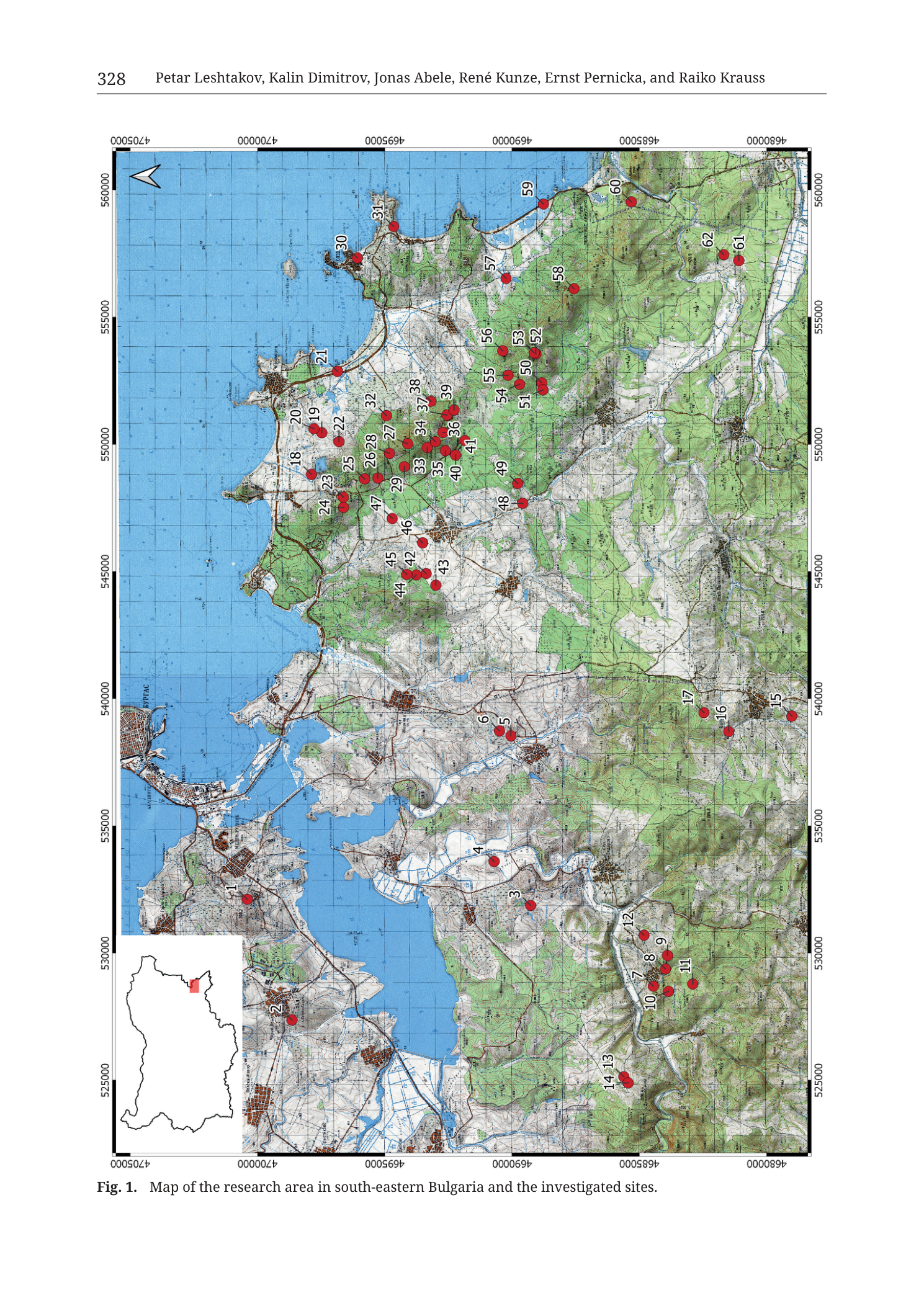
Fig. 1. Map of the research area in south-eastern Bulgaria and the investigated sites.
No separate graphical legend panel, no scale bar, no ratio scale printed on the figure.
No Cyrillic place-name transcription block is required for a dedicated legend; base-map Bulgarian settlement/toponym labels are part of the topographic underlay (small grey type, often partially legible — major ones noted in Description where clearly readable).
Description
TYPE & PURPOSE
This is a regional topographic location map of the project’s research area in south-eastern Bulgaria (Burgas Bay / Medni Rid / Strandzha coastal–inland strip). Overlay purpose: plot every investigated site of the monograph catalogue as a numbered red point (catalogue numbers 1–62 visible), set against a standard contoured topographic base and a national inset key. It is the chapter- or volume-opening overview locating mines, metallurgical sites, settlements, fortresses, and related findspots treated in the subsequent catalogue plates.
FRAME, EXTENT, ORIENTATION
- Single large rectangular map occupying essentially the whole printable page area beneath the running head.
- Orientation is rotated relative to the page: the north arrow in the upper-left of the frame points page-left. Consequently:
- North = page left
- South = page right
- East = page top (Black Sea occupies the page-top band)
- West = page bottom
- Geographic extent: SE Bulgaria Black Sea coast from approximately Burgas Bay and the large western lagoon/lake system, southward past the Chernomorets–Sozopol–Medni Rid coastal headlands, inland across the Medni Rid / Bakarlaka hill country and further inland green ridgelines toward the Strandzha foothills; northward/eastward fringe includes headlands and bays with sites 59–62; west/southwest reaches inland hill clusters around sites 7–14 and 15–17.
- Coordinate system: metric grid with 5 000 m spacing; values match UTM zone 35T (or equivalent Bulgarian projected metric grid in the same numerical range). No projection name string is printed. Eastings ≈ 525000–560000; Northings ≈ 4680000–4705000 — fully consistent with SE Bulgaria / western Black Sea coast.
SCALE
- No graphical scale bar and no ratio scale (e.g. 1:100 000) are printed.
- Scale is recoverable from the coordinate grid: tick spacing = 5 000 m (difference between consecutive labelled values, e.g. 550000−545000 = 5000; 4695000−4690000 = 5000).
- Full frame ground extent roughly:
- Easting span printed labels 525000 → 560000 = 35 km (plus small margins beyond outermost ticks).
- Northing span printed labels 4680000 → 4705000 = 25 km (plus margins).
- Approximate total coverage order of ~35 km (E–W) × ~25 km (N–S).
COORDINATES / GRID
- Full square grid, light lines inside the frame, heavy black outer frame.
- Labels transcribed above; spacing 5 000 m on both axes.
- No geographic (lat/long) graticule.
- Valid SE-Bulgaria UTM 35T range check: Eastings mid-500000s and Northings low-4700000s — pass (no digit-misread flags from the printed frame values themselves).
RELIEF & PHYSIOGRAPHY
- Base relief from contour lines (fine brown contours) plus green woodland/forest fill on higher ground and greyish open lowland tones.
- Contour interval is not stated numerically on the figure; contour density is moderatebump high on the green inland hills (Medni Rid / Bakarlaka block and southern green ranges) and lower on coastal plains and valley floors.
- Major landforms:
- Black Sea coastline — irregular rocky/headland coast along the east (page top), with multiple bays and peninsulas. Prominent coastal salients host dense site clusters (Medni Rid coastal strip: sites ~18–31).
- Burgas Bay / lagoon–lake complex (page mid-left / northern-central of true map) — large blue water bodies, canals, and wetland/lagoon system west of the open sea; urban grey stipple of Burgas agglomeration around them; sites 1 and 2 sit on this western grey urban/lagoon fringe.
- Medni Rid / Rosen hill block — green-wooded NW–SE elongated upland inland of the Chernomorets–Sozopol coast (true map centre-east). This is the principal copper-mining ridge of the collection; the densest red-dot swarm (roughly sites 18–41, plus 42–49 near-inland) sits on and around this block.
- Inland green ridges further west and south — additional wooded hills hosting sites 3–6, 7–14, 15–17, 50–58, 61–62.
- Valley corridors — pale lowland strips with blue rivers between green highs; a major SW–NE valley carries sites 3–6 near brownish road corridors.
HYDROGRAPHY & COAST
- Black Sea — solid blue, occupying the entire eastern band (page top) of the frame, with nested bays.
- Burgas Lakes / lagoon system — large interconnected blue water bodies inland of Burgas Bay on the western/northern sector of the map (true northwest), with engineered canals/channels drawn in blue.
- Multiple smaller blue rivers/streams drain the inland green hills toward the sea and the lagoon system; individual stream names on the base map are in small grey type (mostly too small for confident full transcription on this render).
- Coastal islands/islets appear as small uncoloured or pale rims off headlands (especially opposite the dense coastal cluster zone).
ANTHROPOGENIC / CULTURAL FEATURES
Base-map cultural content:
- Urban/settlement grey built-up polygons: large Burgas agglomeration (west/north of map); smaller coastal towns along Chernomorets–Sozopol strip; scattered inland villages as brown/grey patches along roads.
- Brown/orange road network linking coast and interior; major highways thicker.
- No fortress wall outlines or mine-shaft symbols beyond what the red site dots encode.
Investigated sites (red filled circles + black catalogue numbers):
All visible numbered red sites are listed below as printed, with approximate true-map position relative to coast/hills (true north = page left). Numbers are transcribed as seen; none should be invented.
Northwestern / Burgas lagoon sector (true NW, page mid-left):
- 1 — on/near the Burgas urban–lagoon fringe (west of open bay waters).
- 2 — SW of site 1, further into the western lagoon/urban hinterland (true south-west of 1).
Central-west valley / approaches (true W–central):
- 3 — inland south of Burgas bay, on a pale valley corridor among hills.
- 4 — NE of 3 along the same general coastal-plain/valley approach (closer to a blue waterway).
- 5, 6 — close pair further NE/coastward along a road/settlement belt (6 slightly N or NW of 5).
Southwestern / southern inland green-hill cluster (true SW–S, page lower-right quadrant of the site group):
- 7, 8, 9, 10, 11, 12 — tight cluster on green hills (10 and 7–9 packed; 11 slightly E; 12 NE of the pack).
- 13, 14 — isolated close pair further west (page-lower) of the 7–12 cluster, still on green hill ground.
Southeastern inland hill chain (true SE fringe of the southern inland block):
- 15, 16, 17 — alignment on green ridge (15 outermost SE; 16 west of 15; 17 further NW of 16).
Coastal Medni Rid / Chernomorets–Sozopol headland dense swarm (true E–central coast, densest cloud on the map):
- 18, 19, 20 — near-coast band (20 more seaward/coastal; 18–19 slightly inland of 20).
- 21 — coastal/north of that band along the shoreline (marks a more northerly headland point of the swarm).
- 22, 23, 24, 25, 26, 27, 28, 29 — compact inland-of-coast pack on and just behind the green coastal upslope (Medni Rid western/central flank).
- 30, 31 — farther north along coast from the main pack (31 more northerly; 30 slightly SE of 31) — Chernomorets / northern headland sector.
- 32, 33, 34, 35, 36, 37, 38, 39, 40, 41 — immediate inland Medni Rid green-slope cluster SE/inland of the coastal 22–29 group (ore-field / ridge interior numbers intensively plotted here).
Near-inland west of Medni Rid (true W of ridge, toward bay interior):
- 42, 43, 44, 45, 46, 47 — compact cluster on pale/urban fringe W–SW of the Medni Rid green block (44–45–42–43 tightly nested; 46 N of them; 47 further N/NE toward the ridge).
Further inland SE of Medni Rid core:
- 48, 49 — pair on the inland side of the ridge (49 N of 48).
Northeastern green interior and far NE coast (true NE):
- 50, 51, 52, 53, 54, 55, 56, 57, 58 — extended cluster on green hills NE of Medni Rid (52 near a small green lobation; 57–58 more seaward/NE; 50–56 fill the interior pack).
- 59, 60 — far NE coastal/near-coast pair (59 W of 60) on the outermost NE green-coast fringe of the frame.
Far eastern/southeastern inland margin:
- 61, 62 — close pair on green hills at the true SE/E frame edge (61 S/E of 62).
Catalogue extent: consecutive integers 1 through 62 appear to be represented (all numbers in that range are visible at least once on this render). This figure is the master index map for the site catalogue numbering used throughout the monograph’s plates.
No separate symbol classes (mine vs fortress vs kiln) — every investigated locality uses the same red-dot + number teaching system.
GEOLOGICAL CONTENT
- Not a geological map. No lithologic colour fill, age codes, pluton outlines, vein traces, or keyed ore-deposit lithology.
- Geological context is spatial only: the densest site cloud coincides with the green coastal hill block classically hosting the Rosen ore field / Medni Rid copper district; inland clusters sample secondary valleys and Strandzha-side hills.
STRUCTURAL SYMBOLS
- None of geological type. Grid lines only.
ORE BODIES / DEPOSITS
- Individual Rosen-field named deposits (Rosen, Korucheshme/Kyumyurlaka, Meden Rid/Bakarlak, Sarneshko Kladenche, Propadnala Voda, etc.) are not labelled by name on this map; they are subsumed among the numbered red catalogue points of the Medni Rid dense swarm (especially the ~18–41 block). Name-level identification requires the catalogue plates and other figures in the same monograph, not this overview.
SAMPLE / LOCALITY POINTS
- The red numbered dots are the locality index. No separate geochem-sample ID series, boreholes, or thin-section points.
CROSS-SECTION TRACES
- None.
STRATIGRAPHIC / LEGEND COLUMN
- None. Symbol meaning is self-evident from the caption (“investigated sites”) plus uniform red-dot symbology. Inset serves as location key at national scale only.
COLOUR & SYMBOL SYSTEM
- Base topography palette:
- Blue = sea, lakes, rivers.
- Green = forest/woodland on uplands.
- White–grey–pale = open ground, lowland, cultivated/urban fringe.
- Grey/brown stipple = built-up settlement.
- Brown lines = roads; fine brown = contours.
- Overlay symbology:
- Solid red circle = investigated site.
- Black integer = catalogue number.
- Inset: black country outline, solid red study-area box.
- North arrow: simple open triangle, page-left = north.
INSET LOCATION MAP
- Lower-left (true west / page-bottom-left) white rectangle.
- Bulgaria outline; red rectangle on SE Black Sea coast marking the main-map footprint.
- Places the research area nationally: SE Bulgaria, Burgas district coast — not north Bulgaria, not interior Thrace alone.
SPATIAL RELATIONSHIPS
- Investigated sites form multiple spatial clusters, not a single cloud:
- Burgas lagoon / urban pair (1–2) — far northwest, urban-wetland context rather than Medni Rid ridge.
- Western valley chain (3–6) — corridor sites inland of Burgas Bay.
- Southwestern hill clusters (7–14 and 15–17) — discrete inland groups SW/S of the main ore ridge.
- Medni Rid coastal–ridge mega-cluster (≈18–49) — primary research core: coastal strip + ridge crest + near-inland skirts; corresponds to the copper-mining / archaeometallurgy focus of the collection.
- Northeastern hill and coastal fringe (50–62) — extended NE sampling into adjacent green uplands and far-NE coast.
- Relative to coast: Medni Rid swarm sits on and immediately inland of the headland coast east of Burgas Bay; Burgas-area sites 1–2 are lagoon-side; southern inland clusters are multi-kilometre inland.
- Relative to hydrography: several sites hug blue waterways and lagoon edges (1–4 zone), while the ridge sites sit on green highs above drainages.
- The map encodes coverage geography of the research programme, viz. a coastal-to-inland transect system centred on Medni Rid but deliberately broader (Burgas wetlands through Strandzha-margin hills).
RELATIONSHIP TO OTHER FIGURES
- Caption identity: Fig. 1 of the Leshtakov et al. chapter/contribution in Krauss et al. 2020 (running authors match the catalogue-team roster).
- Functions as the master site-number key for all subsequent catalogue plates in the same volume (e.g. Cat_* plates for Cherni Vrah, Bakar Bokluk, Atia, Akladi Cheiri, Rosen, Kyumyurlaka, Bakarlaka, Budzhaka, Surneshko, Karakachanski Kolibi, Propadnala Voda, Chiplaka, Aivadzhik, Lobodovo Kale, Malkoto Kale, etc.). Each catalogue number on those plates should be locatable as the matching red dot here.
- Companion Medni Rid LiDAR/topographic zooms (e.g. Fig. 16 Kyumyurlaka, Fig. 10 Cherni Vrah trench, topographic overview Fig. 3) nest inside the dense 18–49 cloud of this overview.
- National inset role parallels the small Bulgaria inset on Tzankova 2023 Fig. 1, but this figure is archaeological-site ranked rather than geological-unit ranked.
Consistency Check
- Centroid: no single-site “35T XXXXXX YYYYYY” body-text centroid is printed on this page (overview map of many sites; caption only).
- Map bounds from axis labels:
- Easting ≈ 525000–560000 (labelled ticks)
- Northing ≈ 4680000–4705000 (labelled ticks)
- SE Bulgaria UTM 35T sanity: Eastings mid-5xxxxx and Northings ~4.68–4.70e6 — PASS
- Result: N/A for single-centroid bracketing; frame-level range PASS against known SE-Bulgaria geometry. Black Sea on the high-Easting side and Burgas lagoon system on the northwestern side further corroborate correct axis reading (north = page-left; east = page-top).
Notes
- Filename encodes
Tub_p330while the printed page number on this render is 328; figure number is unambiguously Fig. 1. Likely PDF-page vs book-pagination offset; both recorded. - Map is north-to-page-left (rotated 90°), not north-up. Misreading orientation is the main hazard for this plate; the open north arrow and the Black Sea along page-top are the orientation anchors.
- No scale bar — use the 5 000 m grid for all distance work.
- Individual Bulgarian base-map toponyms in small grey type are only partially legible at this render resolution; they are noted as present but not force-transcribed letter-by-letter where unclear. Site numbers (1–62) are the authoritative overlay content and are fully enumerated.
- No symbol differentiation among site types on this figure; type comes from the catalogue entries keyed by these numbers.
- Exact one-to-one count confirmation: numbers 1–62 inclusive are all attested at least once on the face; if any single numeral were soft-moiré at extreme zoom it would be flagged — none required [illegible] flags at the numbering level used here.
- Alternate deposit names (Rosen, Kyumyurlaka, Propadnala Voda, …) are not printed on this overview.
- None further.