Description
Transcription
Page header (top of full-page render):
- Page number (left): 320
- Running authors (centre/right): René Kunze, Petar Leshtakov, Jonas Abele, and Kalin Dimitrov
Figure (upper half of page):
North arrow (upper-right corner of relief panel, white square inset on black sky strip): open triangle / arrowhead pointing up, labelled “N” beneath.
On-map / on-relief labels (black sans-serif text over the relief model):
- “ore deposit” — placed on the upper-middle / left-central high of the reddish-brown massif (near crest of the dissected pit chain).
- “metallurgical place” — placed on the mid-left lower slope of the main massif, above a smoother brown shoulder, left of a bright track.
- “sunken lanes” — placed on the upper-right green sector, over a dense bundle of parallel linear hollow-ways.
Scale bar (lower-right corner of relief panel, white rectangular box on the relief):
- Label series: 0 | 200 | 400 m
- Bar is a segmented black-and-white bar immediately left of / under those tick numbers; total marked length 400 m.
Figure caption (directly beneath the relief panel, full measure):
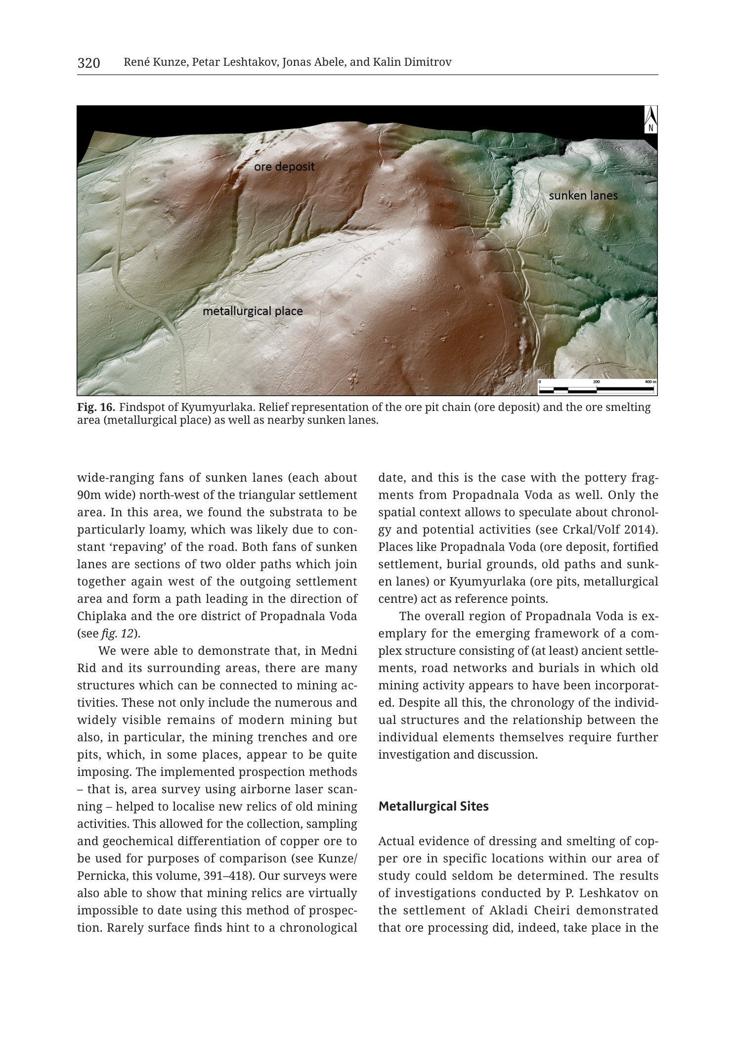
Fig. 16. Findspot of Kyumyurlaka. Relief representation of the ore pit chain (ore deposit) and the ore smelting area (metallurgical place) as well as nearby sunken lanes.
Body text beneath the figure (two columns; transcribed fully as printed):
Left column:
wide-ranging fans of sunken lanes (each about 90m wide) north-west of the triangular settlement area. In this area, we found the substrata to be particularly loamy, which was likely due to constant ‘repaving’ of the road. Both fans of sunken lanes are sections of two older paths which join together again west of the outgoing settlement area and form a path leading in the direction of Chiplaka and the ore district of Propadnala Voda (see fig. 12).
We were able to demonstrate that, in Medni Rid and its surrounding areas, there are many structures which can be connected to mining activities. These not only include the numerous and widely visible remains of modern mining but also, in particular, the mining trenches and ore pits, which, in some places, appear to be quite imposing. The implemented prospection methods – that is, area survey using airborne laser scanning – helped to localise new relics of old mining activities. This allowed for the collection, sampling and geochemical differentiation of copper ore to be used for purposes of comparison (see Kunze/Pernicka, this volume, 391–418). Our surveys were also able to show that mining relics are virtually impossible to date using this method of prospection. Rarely surface finds hint to a chronological
Right column (continuation + new heading):
date, and this is the case with the pottery fragments from Propadnala Voda as well. Only the spatial context allows to speculate about chronology and potential activities (see Crkal/Volf 2014). Places like Propadnala Voda (ore deposit, fortified settlement, burial grounds, old paths and sunken lanes) or Kyumyurlaka (ore pits, metallurgical centre) act as reference points.
The overall region of Propadnala Voda is exemplary for the emerging framework of a complex structure consisting of (at least) ancient settlements, road networks and burials in which old mining activity appears to have been incorporated. Despite all this, the chronology of the individual structures and the relationship between the individual elements themselves require further investigation and discussion.
Metallurgical Sites
Actual evidence of dressing and smelting of copper ore in specific locations within our area of study could seldom be determined. The results of investigations conducted by P. Leshkatov on the settlement of Akladi Cheiri demonstrated that ore processing did, indeed, take place in the
(Text cuts off at the bottom of the page render; the last printed line ends mid-sentence after “in the”.)
No coordinate-grid ticks, no UTM/lat-long numbers, no contour value labels, no numeric elevation scale, and no separate graphical legend appear on the relief panel.
Description
TYPE & PURPOSE
This is a LiDAR / airborne-laser-scanning digital terrain relief representation (hillshade-style DSM/DTM visualisation with multi-colour height tinting) of the Kyumyurlaka findspot in the Medni Rid / Rosen ore field (SE Bulgaria). The caption states the purpose explicitly: to show the ore pit chain labelled “ore deposit”, the ore-smelting area labelled “metallurgical place”, and nearby sunken lanes, as a three-dimensional surface model of one key mining–metallurgy cluster in the monograph’s survey.
The image is a full-page journal/book page render (Krauss et al. 2020, Tübingen University Press monograph chapter by Kunze, Leshtakov, Abele & Dimitrov). The upper half is the relief figure; the lower half continues the chapter’s archaeological/geoarchaeological text and begins a section headed “Metallurgical Sites”.
FRAME, EXTENT, ORIENTATION
- Single rectangular relief panel with a black upper strip (sky / no-data border at the far north of the view).
- Orientation: north is up. A white square north-arrow inset with an upward-pointing open triangle and the letter “N” sits in the upper-right corner of the panel.
- Approximate geographic extent: local site-scale view of one ridge/massif and its eastern apron — a few hundred metres to ~1+ km across the frame (see Scale). No coastline is visible; this is an inland hill/ridge detail of the Medni Rid area.
- No printed coordinate system, projection name, grid, or graticule. Placement in the broader Rosen field rests on the captions and body text (Kyumyurlaka linked textually to Propadnala Voda, Chiplaka, and Medni Rid).
SCALE
- Graphical scale bar, lower-right of the relief panel: 0 | 200 | 400 m, black-and-white segmented bar.
- No ratio scale (e.g. 1:5 000) is printed.
- Represented ground distance: the scale alone marks 400 m. Visually, the full N–S and E–W extents of the entire panel are several times that bar — on the order of roughly ~1.2–1.8 km across the longer axis (visual estimate only against the 400 m bar; not a surveyed measurement). The main ore-pit massif occupies the central several hundred metres of the frame.
COORDINATES / GRID
- None printed on the figure. No Easting/Northing ticks, no UTM zone label, no lat/long.
- Body text on this page does not print a 35T centroid for Kyumyurlaka; the catalogue-style UTM consistency check therefore has no numeric centroid to apply against axis labels (see Consistency Check).
RELIEF & PHYSIOGRAPHY
- Rendering method: high-resolution LiDAR-derived relief model with multidirectional or single-direction hillshading plus continuous height/hypsometric colour tint:
- Cool greens and grey-greens on lower/eastern flanking terrain.
- Warm pale beige to reddish-brown on the elevated central massif and crest.
- Soft green-beige transition on the west and northwest flanks.
- No contour lines and no numeric spot heights or elevation colour bar are printed; relative height is conveyed only by the tint gradient and cast shadows of the hillshade.
- Major landforms visible:
- Central reddish-brown massif / ridge crest — heavily fretted, pitted surface occupying the centre and upper-centre of the panel. This is the ore-deposit mass identified by the “ore deposit” label. The surface is riddled with many small, roughly circular to irregular closed hollows and linear trenches — the ore pit chain / pit-and-trench mining topography.
- Western / southwestern shoulder — smoother, pale beige to light brown slope descending leftward from the massif; hosts the “metallurgical place” label and a clear bright linear track/road arcing across it.
- Eastern green apron — lower, cooler-tinted terrain to the right of the massif; cut by dense parallel to sub-parallel linear channels (sunken lanes) and gentler valley hollows. The “sunken lanes” label sits over the densest bundle in the upper-right quadrant.
- Northern high ground and northern black border — the crest continues toward the top edge under the black strip; short spurs and saddles are visible left and right of the labelled ore-deposit zone.
- Southern lower slopes — in the lower-centre and lower-right, the massif drops into more branched erosional gullies and lighter-toned spurs; several linear tracks cut these slopes too.
- Elevation range is not quantified on the figure. The colour gradient (green → beige → red-brown) implies that the labelled ore-deposit crest is the local topographic high relative to the green sunken-lane sector and the western metallurgical shoulder.
HYDROGRAPHY & COAST
- No open coastline, sea, lakes, or named rivers are shown.
- Fine dendritic drainage / gully grooves collect on the flanks of the massif and drain mainly toward the green eastern and lower-right sectors and the pale western apron; flow direction is only inferable from slope (off the crest into the lower aprons). No stream names are labelled.
ANTHROPOGENIC / CULTURAL FEATURES
Three archaeological feature classes are labelled on the relief:
-
Ore deposit (ore pit chain)
- Label “ore deposit” on the fretted red-brown crest.
- Surface expression: a dense field of incised circular, elliptical, and coalesced pits and short mining trenches cutting the hilltop and upper flanks. Individual pits form a chain / cluster running roughly along the crest and upper slopes (the caption’s “ore pit chain”). Pit rims cast sharp hillshade shadows, giving a cratered appearance that contrasts with the smoother surrounding slopes. No modern mine buildings, headframes, or open-cast benches of large industrial shape are obvious in this crop — the microtopography is of many small open pits/trenches rather than a single large quarry face.
-
Metallurgical place (ore-smelting area)
- Label “metallurgical place” on the mid-west lower shoulder of the massif.
- Surface expression at the labelled locus is a relatively smoother brown platform/slope compared with the pit-riddled crest above it. A light-toned road/track arcs past or through this zone (bright linear feature running roughly N–S to NW–SE on the left side of the panel). The figure itself does not annotate kilns, slag heaps, or furnace footprints as separate symbols; identification as the smelting area rests on the label and caption (“ore smelting area (metallurgical place)”).
-
Sunken lanes
- Label “sunken lanes” on the upper-right green sector.
- Surface expression: numerous parallel and braided linear hollow-ways (negative linear grooves) cutting the green apron east/northeast of the massif. They appear as dark, shadowed troughs with raised interfluves between them — classic multi-track hollow-way fans in LiDAR relief. Body text on the same page (surrounding context for the Medni Rid survey, partially continuous from a previous figure/paragraph) describes sunken-lane fans “each about 90m wide” and older paths linking toward Chiplaka and the Propadnala Voda ore district — that paragraph is not exclusively a caption for this panel’s east-side lanes, but it supplies the monograph’s interpretive language for the same feature class.
Additional anthropogenic linear features visible but unlabelled:
- A prominent pale track/road on the western side (associated with / passing the metallurgical place), curving across the beige shoulder.
- Fainter path/track lines on the southern and southeastern flanks, some connecting into or crossing the sunken-lane zone.
- Possible faint terracing or spoil shoulders around pit rims on the deposit massif (observed as low annular rims in the hillshade; not labelled).
No fortress symbols, settlement polygons, burial markers, building footprints, sample-point numbers, or modern village names are drawn on this panel.
GEOLOGICAL CONTENT
- This is not a geological map. No lithostratigraphic units, age codes, pluton outlines, fault traces, bedding attitudes, or mineral/alteration polygons are printed.
- Geological content is only implicit: the relief shows a mined ridge mass hosting an ore-pit chain (copper district context given by the monograph and by cross-references to Medni Rid, Propadnala Voda, Chiplaka, Kunze/Pernicka copper-ore chapter pp. 391–418). Rock type, age, and vein structure are not stated on the figure.
STRUCTURAL SYMBOLS
- None in the geological-map sense (no fault ticks, fold axes, dip symbols).
- The only “structure” symbols are the microtopographic expressions of pits, trenches, tracks, and sunken lanes described above.
ORE BODIES / DEPOSITS
- Kyumyurlaka (also spelled Kyumyurlaka in the caption/body; known elsewhere in the collection as Korucheshme / related to the Rosen-field deposit chain) is the sole deposit addressed here.
- Representation: as a surface pit chain on the red-brown crest, not as a planar vein cross-section or drill marker.
- Spatial association: deprive-from-hilltop mining immediately above and inland of the western metallurgical place; sunken-lane network adjacent on the east. Body text groups Kyumyurlaka as “ore pits, metallurgical centre” — a paired extraction + processing reference point analogous to the more compound Propadnala Voda complex (ore deposit, fortified settlement, burial grounds, old paths and sunken lanes).
SAMPLE / LOCALITY POINTS
- No numbered sample dots, borehole collars, or geochem IDs on the relief.
- Body text refers the copper-ore sampling/geochemistry programme to Kunze/Pernicka (this volume, 391–418) without listing sample numbers on this page.
CROSS-SECTION TRACES
- None (no A–A′ / B–B′ lines).
STRATIGRAPHIC / LEGEND COLUMN
- No stratigraphic column.
- No graphical symbol legend; the three printed place-type labels on the relief serve as the only key.
COLOUR & SYMBOL SYSTEM
- Continuous hypsometric / slope-aware tint:
- Red–brown / warm terracotta = higher elevation / massif crest (ore-deposit zone).
- Beige / pale tan = intermediate shoulders (including metallurgical place).
- Green / grey-green = lower apron, especially east sunken-lane sector.
- Hillshade provides high-frequency relief (pit rims, lane troughs, track margins cast light/shadow).
- Annotation style: plain black place labels without leader arrows or point symbols; meaning encoded by after-label collocated relief texture.
- North arrow: white square box, black open triangle, “N”.
- Scale: black/white bar with metric labels 0–200–400 m.
SPATIAL RELATIONSHIPS
- The ore-pit chain occupies the highest fretted surface of the central massif (“ore deposit”).
- The metallurgical / smelting place sits on a lower, smoother western shoulder of the same mass, tens to a few hundred metres downslope (visual estimate against the 400 m bar) — extraction on crest, processing immediately off-crest to the west/southwest.
- Sunken lanes concentrate on the eastern green apron, separated from the metallurgical place by the massif body; they suggest access/communication corridors on the opposite flank from smelting, consistent with a multi-approach logistic system around the mined high.
- A bright west-side track links past the metallurgical place, connecting that processing locus into the regional path network pictorially; the text ties path fans in the wider Medni Rid system toward Chiplaka and Propadnala Voda.
- Relative to the Rosen ore-field chain known from companion figures: Kyumyurlaka is one of the named intermediate deposits (Korucheshme/Kyumyurlaka) of the NW–SE Medni Rid alignment; this figure is a site-scale LiDAR zoom, not a field-wide geological map.
- The figure pair of functions — pits + metallurgy + lanes — is the spatial message: Kyumyurlaka as a local production node with extraction, processing, and mapped approaches.
RELATIONSHIP TO OTHER FIGURES
- Caption identity: Fig. 16 of the Kunze/Leshtakov/Abele/Dimitrov chapter in Krauss et al. 2020.
- Textual cross-references printed on the same page:
- “see fig. 12” — path system toward Chiplaka and Propadnala Voda (companion topographic/LiDAR figure earlier in the chapter).
- “see Kunze/Pernicka, this volume, 391–418” — copper ore sampling and geochemistry chapter.
- “see Crkal/Volf 2014” — chronology/activity speculation citation.
- Comparison sites: Propadnala Voda (multi-component complex) and Akladi Cheiri (Leshtakov investigations on ore processing — headed newly under “Metallurgical Sites”).
- Companion catalogue plates elsewhere in the same monograph treat Kyumyurlaka as Cat. mining/metallurgical entries (e.g. Cat_p350_n25-26) and other Medni Rid LiDAR zooms (e.g. Cherni Vrah trench Fig. 10 on p. 318 in related material).
Consistency Check
- Centroid: none printed on this page for Kyumyurlaka (no “35T XXXXXX YYYYYY” string in the figure or body text of this PNG).
- Map bounds: no Easting/Northing axis labels on the relief.
- Result: N/A — catalogue-style UTM bracket check cannot be performed on this figure. Geographic placement rests on labelled place name (Kyumyurlaka) and monograph context within Medni Rid.
Notes
- Filename encodes
Tub_p322while the printed page number on this render is 320; the figure number is unambiguously Fig. 16. Discrepancy is likely PDF page vs book pagination offset; both are recorded. - Caption spelling is “Kyumyurlaka”; body text uses the same form. Alternate spellings known from the broader collection (Kyumyurlaka / Korucheshme / related Rosen-field names) are not printed as synonyms on this page.
- Author running head lists “Petar Leshtakov”; body text later spells the investigator “P. Leshkatov” (likely a typesetting variant/typo of Leshtakov) — transcribed as printed in each location.
- Body text above and beside “Metallurgical Sites” is continuous chapter prose, not exclusive caption for every sunken-lane descriptor; the left-column “90m wide” fans paragraph continues discussion from a previous figure (settlement/path complex) while this panel’s own caption is only the Fig. 16 sentence.
- Page render is truncated mid-sentence at the bottom (“did, indeed, take place in the”); no further lines are on this PNG.
- No UTM centroid or grid — Consistency Check N/A.
- Relative metre estimates off the scale bar are visual only.
- “Ore deposit” here means the surface expression of the pit chain, not a mapped ore body in plan view with assay polygons.
- None further.