Description
Transcription
Page header
- Page number (upper left): 316
- Running authors head: “René Kunze, Petar Leshtakov, Jonas Abele, and Kalin Dimitrov”
Fig. 10 — panel labels (as printed on the composite frame)
- a — upper-right corner of the left (large) panel
- b — upper-left corner of the upper-right photo panel
- c — upper-left corner of the lower-right photo panel
Fig. 10 — panel a annotations
- North arrow (lower-left of panel a): open triangle with shaft, pointing roughly upper-left of the image frame (i.e. map north is toward the upper-left of the orthophoto as printed — the mosaic is rotated relative to page-up).
- Scale bar (bottom edge of panel a, left): short black-and-white segmented bar; numeric labels on the bar are very small on this page render — a “0” is legible at the left end; full metre values at intermediate/right ticks are not reliably readable at this resolution ([illegible] for exact metre total). Bar is only a small fraction of the panel width.
Fig. 10 caption (directly under the three-panel grey frame)
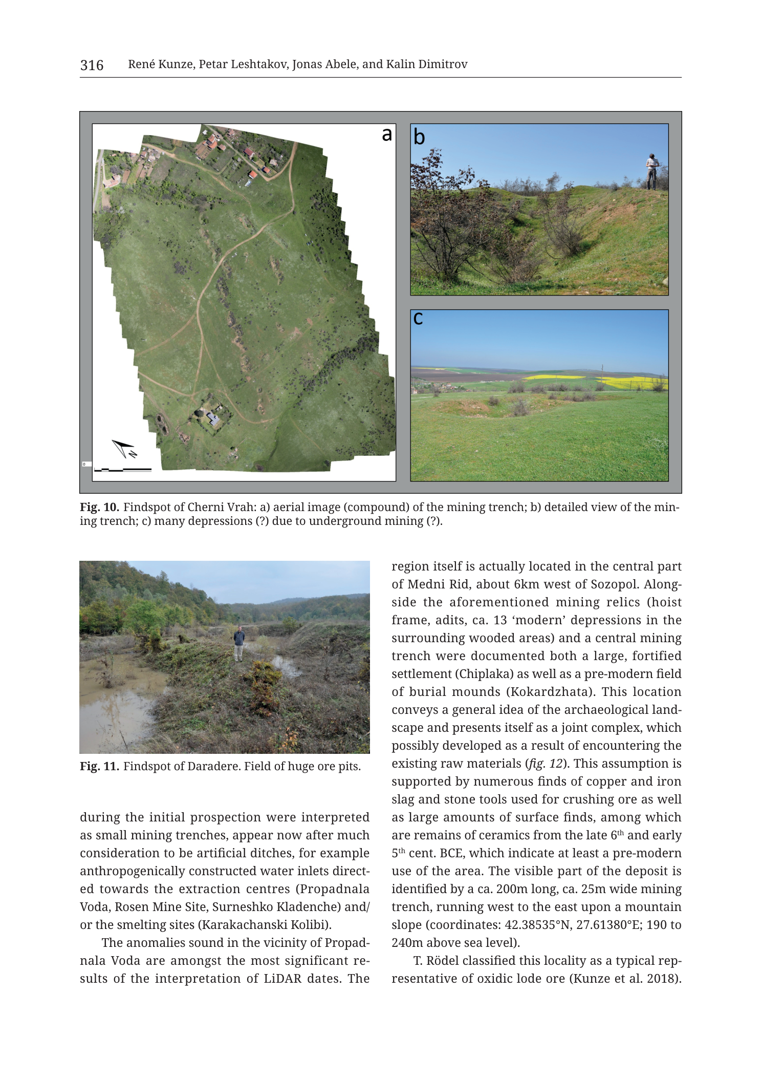
“Fig. 10. Findspot of Cherni Vrah: a) aerial image (compound) of the mining trench; b) detailed view of the mining trench; c) many depressions (?) due to underground mining (?).”
Fig. 11 caption (under the separate lower-left photograph)
“Fig. 11. Findspot of Daradere. Field of huge ore pits.”
Body text on the same page
Column under Fig. 11 (left, continuing prior page then new paragraphs):
“during the initial prospection were interpreted as small mining trenches, appear now after much consideration to be artificial ditches, for example anthropogenically constructed water inlets directed towards the extraction centres (Propadnala Voda, Rosen Mine Site, Surneshko Kladenche) and/or the smelting sites (Karakachanski Kolibi).
The anomalies sound in the vicinity of Propadnala Voda are amongst the most significant results of the interpretation of LiDAR dates. The“
Right column (continues Propadnala Voda / Medni Rid discussion — not Cherni Vrah–specific figure callout on this crop, but related ore-localities prose):
“region itself is actually located in the central part of Medni Rid, about 6km west of Sozopol. Alongside the aforementioned mining relics (hoist frame, adits, ca. 13 ‘modern’ depressions in the surrounding wooded areas) and a central mining trench were documented both a large, fortified settlement (Chiplaka) as well as a pre-modern field of burial mounds (Kokardzhata). This location conveys a general idea of the archaeological landscape and presents itself as a joint complex, which possibly developed as a result of encountering the existing raw materials (fig. 12). This assumption is supported by numerous finds of copper and iron slag and stone tools used for crushing ore as well as large amounts of surface finds, among which are remains of ceramics from the late 6th and early 5th cent. BCE, which indicate at least a pre-modern use of the area. The visible part of the deposit is identified by a ca. 200m long, ca. 25m wide mining trench, running west to the east upon a mountain slope (coordinates: 42.38535°N, 27.61380°E; 190 to 240m above sea level).
T. Rödel classified this locality as a typical representative of oxidic lode ore (Kunze et al. 2018).“
Description
TYPE & PURPOSE
Multi-photograph findspot documentation plate for mining landscapes in the Medni Rid survey chapter. The filename and primary three-panel composite target Cherni Vrah (Fig. 10 a–c); the same PNG page also carries Fig. 11 (Daradere) as a second findspot photo. Purpose: show the Cherni Vrah mining trench from air and ground, plus ground evidence of possible prospection/collapse pits, and (Fig. 11) the Daradere field of large ore pits with a human scale figure.
FRAME & PANEL LAYOUT
- Upper block — Fig. 10: grey-bordered composite.
- (a) Large orthophoto / compound aerial mosaic on the left (~2/3 of composite width), full height of the upper frame.
- (b) Ground photograph, upper right.
- (c) Ground photograph, lower right, stacked under (b).
- Lower-left — Fig. 11: separate landscape photograph of Daradere ore pits with a standing person.
- Remaining page area: two-column body text about Propadnala Voda / Medni Rid mining trench metrics and related localities (water inlets, Chiplaka, Kokardzhata, etc.).
Fig. 10a — Aerial image (compound) of the Cherni Vrah mining trench
Type & view
- Vertical/near-vertical compound aerial orthophoto mosaic (caption: “aerial image (compound)”) of a rural strip of grassland, scrub, dirt tracks, and scattered buildings.
- Panel is a stitched footprint with an irregular polygonal outer edge (mosaic seam outline) on a white backing inside the grey frame.
Orientation & scale
- North arrow in lower-left of the mosaic points toward the upper-left of the printed panel (mosaic rotated ~45° relative to page axes).
- Scale bar along the bottom of the mosaic: short bar with 0 at left; total length in metres not legible at page-render resolution.
- Ground coverage: multi-hectare agricultural/pasture parcel; exact metres across not measurable without a legible bar total.
What is visible
- Primary feature — mining trench: a long, pale, slightly sinuous linear excavation / hollow trace running approximately through the centre of the mosaic as a lighter strip between green grass fields. The trench appears as a shallow elongated cutting with slightly raised or bare margins in places, distinct from the branching dirt track network that crosses and parallels parts of the field system.
- Tracks/roads: pale unpaved paths form a branching Y / dendritic pattern across the green surface, connecting building clusters.
- Built structures:
- Northern cluster (toward the lower-building-density top of the mosaic as printed): multiple small rectangular roofs of farmhouses/outbuildings with yards and trees — a hamlet or farmstead strip along the upper edge of the photographed block.
- Southern/isolated buildings nearer the bottom of the mosaic: one or more discrete roof clusters (pale roofs) set in open grass, adjacent to the trench/track zone — possibly mine-related or farm structures at the trench’s approach.
- Vegetation: mixed open grass pasture and darker green scrub/tree patches; denser tree cover along parts of the perimeter of the mosaic footprint.
- Field pattern: sub-rectangular to irregular grass parcels delimited by tracks and vegetation lines; no open-cast grid of modern industrial benches is visible — the mining trace reads as a single elongated trench feature in a rural landscape.
Interpretation (caption-led)
- Caption identifies the linear feature set as the mining trench of the Cherni Vrah findspot.
- Cherni Vrah is the NW ore-deposit locality of the broader survey (see Tub Fig. 3 topographic overview — “Cerni Vrah” west of Medni Rid / near the lake system), distinct from the central Medni Rid Propadnala Voda trench metrics discussed in the right-hand body text of this same page.
Fig. 10b — Detailed view of the mining trench
Type & view
- Oblique ground colour photograph, looking along / slightly across a linear earthwork under clear blue sky.
What is visible
- A grassy ridge-and-hollow trench landform: green turf-covered banks with a central linear depression or crest of spoil/berm running into the mid-ground.
- Scrubby deciduous bushes and small trees (brownish/reddish early-spring or autumn foliage on left and mid) grow on and beside the trench flanks.
- Human scale: a person stands on the crest of the right-hand bank near the upper right of the frame — full figure, outdoor clothing — providing approximate height scale (trench relief on the order of one to a few person-heights at the near bank).
- Background: continuing open grass and scrub under bright daylight; no buildings in this tight crop.
- The landform matches a backfilled or vegetated open mining trench / elongated prospecting cut still expressed as a topographic ridge–furrow pair.
Fig. 10c — Many depressions (?) due to underground mining (?)
Type & view
- Oblique ground colour photograph, wider landscape view under bright blue sky with light cloud.
What is visible
- Foreground/mid-ground: several shallow circular to oval grassy depressions and low annular rims on a green pasture surface — pit-like hollows a few metres across (person not in frame; indent sizes comparable to small surface collapses or prospect pits).
- Caption marks both “depressions (?)“ and “underground mining (?)” with question marks — the plate presents these as candidate surface expressions of underground working / collapse, not as proven shafts.
- Background: open agricultural plain with yellow-flowering fields (rape/canola or similar), brown ploughed strips, distant tree lines and low hills/horizon; light poles and possibly distant structures on the right skyline.
- Viewshed is countryside open land, more plateau-edge than deep forest — profitable for spotting shallow depression fields.
Fig. 11 — Findspot of Daradere. Field of huge ore pits
(Present on the same PNG page; separate figure number.)
Type & view
- Ground-level colour photograph of a wet, overgrown linear/swollen pit field.
What is visible
- A standing adult person (dark jacket, light trousers) centred on a raised turf/spoil barrier between water-filled or muddy elongated hollows — clear human scale for pit depth and width.
- Elongated flooded / marshy excavations on either side of the central berm; vegetation (grasses, brambles, bushes) heavily colonises spoil and water edges.
- Background: wooded hillslope with mixed deciduous forest in full/late leaf — Daradere’s “field of huge ore pits” in a valley-edge setting.
- Relates to the Daradere ore-deposit symbol on the Tub Fig. 3 regional overview (south-west sector of the survey area).
SPATIAL / RESEARCH RELATIONSHIPS
- Cherni Vrah (Fig. 10) and Daradere (Fig. 11) are two distinct western/south-western ore-deposit findspots in the Kunze et al. survey set, separate from the main NE Medni Rid Rosen–Propadnala Voda chain.
- Fig. 10 documents Cherni Vrah at three scales: compound air photo of the trench in its farm landscape → ground detail of the vegetated trench embankment → ground view of questionable depression clusters possibly linked to underground work.
- Body text on this page largely continues the Propadnala Voda narrative (central Medni Rid, ~6 km west of Sozopol; ~200 m long × ~25 m wide W–E trench; coordinates 42.38535°N, 27.61380°E; 190–240 m a.s.l.; Chiplaka settlement; Kokardzhata mounds; oxidic lode ore per T. Rödel / Kunze et al. 2018) and water-inlet ditches toward Propadnala Voda, Rosen Mine Site, Surneshko Kladenche, and Karakachanski Kolibi smelting — that prose is neighbouring-locality context, not a direct dense caption for Cherni Vrah panels. Fig. 12 is cross-referenced for the joint complex idea.
- Left-column text also revises initial LiDAR “small mining trench” interpretations into artificial water-inlet ditches feeding extraction/smelting centres — methodological caution relevant when reading depression/trench photo evidence (including Fig. 10c’s question-marked pits).
RELATIONSHIP TO OTHER FIGURES
- Fig. 10–11 of the Kunze/Leshtakov/Abele/Dimitrov chapter, Krauss et al. 2020, printed page 316 (filename Tub_p318).
- Regional position: Tub_p314_Fig3 marks Cerni Vrah and Daradere as ore-deposit symbols.
- Methods context: Tub_p311_Fig1 workflow; LiDAR discussion on the same pages.
- Catalogue-style close-ups of related named sites appear among the Cat_p* plates (Cherni Vrah mining site, Propadnala Voda, Surneshko, Karakachanski Kolibi, Chiplaka geomagnetic, etc.).
- Forward reference: fig. 12 in the body text (archaeological landscape joint complex) — a later figure in the same chapter sequence.
Consistency Check
- Body-text coordinates on this page (42.38535°N, 27.61380°E) refer to the Propadnala Voda central Medni Rid trench in the right-column prose, not to a printed centroid for Cherni Vrah on Fig. 10.
- No UTM axis grid on Fig. 10a beyond the small scale bar; no 35T easting/northing pair printed for Cherni Vrah on this page.
- Result: N/A for Fig. 10 Cherni Vrah (no catalogue centroid + map-axis pair to cross-check on this plate). The Propadnala Voda lat/long in the text is recorded under Transcription for completeness and lies in the expected Sozopol inland window (~42.38°N, 27.61°E).
Notes
- Filename Tub_p318 vs printed page 316: PDF vs book pagination difference.
- Fig. 11 (Daradere) is on the same PNG as Fig. 10; both are described because both are visible in the image file, but the canonical basename targets Cherni Vrah / Fig. 10.
- Orthography: caption “Cherni Vrah” vs map label “Cerni Vrah” on Fig. 3 — same site, retained per plate.
- Fig. 10a scale-bar metre totals and any tiny corner coordinates are not legible at this render; marked rather than guessed.
- Fig. 10c caption’s double “(?)” is authorial uncertainty about pit genesis (underground mining vs other); description keeps that uncertainty.
- Right-column Propadnala Voda metrics and coordinates must not be silently reassigned to Cherni Vrah.
- North arrow on 10a indicates mosaic rotation; “north-up” page assumption does not hold inside panel a without applying the arrow.
- None further.