Description
Transcription
Page header
- Page number (upper left): 312
- Running authors head: “René Kunze, Petar Leshtakov, Jonas Abele, and Kalin Dimitrov”
Coordinate grid (UTM metres; values as printed on frame)
Easting (top edge, left → right):
- 530000
- 540000
- 550000
- 560000
Easting (bottom edge, left → right): same tick series aligned under the map — 530000, 540000, 550000, 560000
Northing (left edge, top → bottom):
- 4700000
- 4690000
- 4680000
Northing (right edge, top → bottom): matching 4700000, 4690000, 4680000
(Map frame spans west of 530000 slightly to east of 560000, and south of 4680000 slightly to north of 4700000 — ticks mark the labelled values.)
North arrow
- Simple open triangle north arrow labelled “N” in the upper-right corner of the map face (over the sea).
Scale bar (lower right, above/beside legend)
- Bar labelled: 0 | 2.5 | 5 | 7.5 | 10 km
Legend (lower-right white box)
Legend
sites
- ⊠ (black square with pale X / crossed-box pick-style symbol) — Ore deposit
- ● (filled red circle) — Settlement
- ▲ (filled black triangle / mound symbol) — Burial mound
- ⚒ (black crossed-tools / metallurgy symbol — schematic tongs/hammer style as printed) — Metallurgy
- ● (filled green circle) — Fortress
Background: SRTM
Place names and site labels printed on the map face
Ore deposits (crossed-box / deposit symbols) with labels:
- Cerni Vrah — NW sector, north of the large purple lake body (~east of 530000, south of 4700000)
- Varli Bryag — northern central plain near north edge (~between 530000–540000, near 4700000)
- Zidarovo — west-central (~east of 530000, near 4690000)
- Echmen Bair/Gabar — SW of centre-west, with adjacent red settlement dots (~533000–535000 area, ~4686000–4688000)
- Daradere — south-central west (~535000–538000, near/just above 4680000) with metallurgy symbol nearby
- Metoha — north of Rosen cluster (~548000–550000, ~4697000)
- Rossen — northern part of Medni Rid cluster (label “Rossen” near deposit/metallurgy cluster; ~548000–550000, ~4695000)
- Rosen — main Medni Rid highland label near centre of the NE ridge cluster (~549000–551000, ~4692000–4694000)
- Kjumurlăka — east of Rosen in the ridge (~551000–552000)
- Carneško Kladence — SE of Kjumurlăka / on ridge (~552000–553000)
- Propadnala Voda — further SE on the ridge chain (~553000–554000)
Settlements (red filled circles) with labels:
- Atia 1 — northernmost red settlement near coast (~548000–550000, near 4700000)
- Chernomorets — coastal north-east (~552000–554000, ~4698000–4700000)
- Akladi cheiri — near Sozopol / NE coast (~554000–556000)
- Sozopol — NE coastal peninsula town (~556000–558000, ~4696000–4698000)
- Budzhaka — east coast south of Sozopol (~558000–560000, ~4694000–4696000)
- Alepu — SE coastal settlement (~558000–560000, ~4690000–4692000)
- Veselie — inland south of Medni Rid ridge (~552000–554000, ~4688000–4690000)
- Additional unlabeled red settlement dots: west near Echmen Bair/Gabar (pair/cluster); south-central red dots between Daradere and Veselie; scattered singles in the central plain and ridge fringe
Fortresses (green filled circles):
- Green fortress symbols scattered on/near Medni Rid and south — including a clear green point SSE of Rosen cluster and others in the southern/central area (exact names not all labelled; fortress class per legend)
Burial mounds (black triangle symbols):
- Dense cluster of black triangles on and around the Medni Rid highland mass (centre-east of map, around Rosen / Kjumurlăka / ridge crest)
- Additional triangles SE of the main ridge and in southern hills
- Sporadic triangles westward and southward of the main cluster
Metallurgy (crossed-tools symbols):
- Multiple metallurgy symbols in the Rosen–Rossen–Metoha–Kjumurlăka corridor on Medni Rid
- Metallurgy symbol near Daradere (south)
- Additional metallurgy marks east/SE of the main ridge cluster and west near deposit sites
Other geographic labels / hydrography:
- Large purple/lavender filled water body in the NW quadrant = Burgas Lake / Mandra Lake complex (unlabelled on this figure; geographic identity from position relative to Cerni Vrah, Varli Bryag, Zidarovo)
- Black Sea: light blue field along the entire eastern map edge with irregular coastline (Chernomorets–Sozopol–Budzhaka–Alepu)
Figure caption
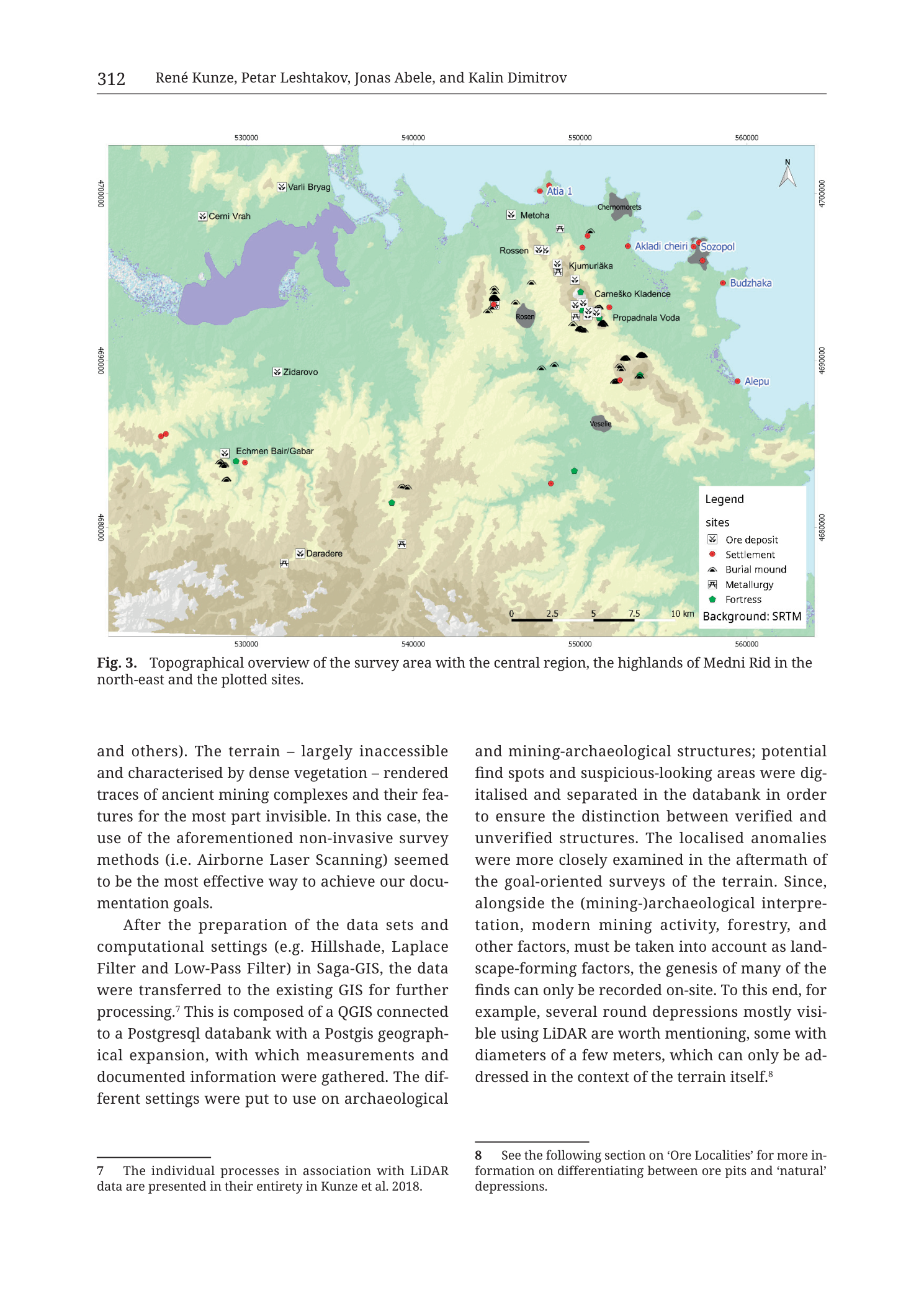
“Fig. 3. Topographical overview of the survey area with the central region, the highlands of Medni Rid in the north-east and the plotted sites.”
Body text on the same page (two columns beneath the figure)
Left column (continuation):
“and others). The terrain – largely inaccessible and characterised by dense vegetation – rendered traces of ancient mining complexes and their features for the most part invisible. In this case, the use of the aforementioned non-invasive survey methods (i.e. Airborne Laser Scanning) seemed to be the most effective way to achieve our documentation goals.
After the preparation of the data sets and computational settings (e.g. Hillshade, Laplace Filter and Low-Pass Filter) in Saga-GIS, the data were transferred to the existing GIS for further processing.⁷ This is composed of a QGIS connected to a Postgresql databank with a Postgis geographical expansion, with which measurements and documented information were gathered. The different settings were put to use on archaeological“
Right column:
“and mining-archaeological structures; potential find spots and suspicious-looking areas were digitalised and separated in the databank in order to ensure the distinction between verified and unverified structures. The localised anomalies were more closely examined in the aftermath of the goal-oriented surveys of the terrain. Since, alongside the (mining-)archaeological interpretation, modern mining activity, forestry, and other factors, must be taken into account as landscape-forming factors, the genesis of many of the finds can only be recorded on-site. To this end, for example, several round depressions mostly visible using LiDAR are worth mentioning, some with diameters of a few meters, which can only be addressed in the context of the terrain itself.⁸”
Footnotes
- 7 — “The individual processes in association with LiDAR data are presented in their entirety in Kunze et al. 2018.”
- 8 — “See the following section on ‘Ore Localities’ for more information on differentiating between ore pits and ‘natural’ depressions.”
Description
TYPE & PURPOSE
This is a regional topographic / site-distribution overview map of the Medni Rid survey area (SE Bulgaria, Burgas coast). Background is an SRTM elevation tint/relief; overplotted are archaeological and mining site classes (ore deposits, settlements, burial mounds, metallurgy loci, fortresses). Purpose (caption): show the survey area with the central region, the highlands of Medni Rid in the north-east, and plotted sites. It is the geographic key map linking the multi-method survey workflow (Fig. 1 of the same chapter) to the dense findspot inventory of the monograph.
FRAME, EXTENT, ORIENTATION
- Single landscape map occupying the upper half of page 312; caption beneath; two-column methods text and footnotes below.
- Orientation: north up; open triangle N arrow upper-right over the sea.
- Geographic extent: from inland west of the Burgas/Mandra lake system to the Black Sea coast (Chernomorets–Sozopol–Budzhaka–Alepu), and from north of Atia/Varli Bryag to south of Daradere — i.e. the full Medni Rid survey theatre including Varli Bryag, Zidarovo, and coastal margins.
- Coordinate system: projected metric grid in metres with labels 530000–560000 E and 4680000–4700000 N. Values match UTM zone 35N / WGS-style metre easting–northing used elsewhere in the catalogue (35T …). No projection name string is printed beyond the numeric ticks and “Background: SRTM”.
SCALE
- Graphical scale bar: 0 – 2.5 – 5 – 7.5 – 10 km.
- No ratio scale (1:x) printed.
- Full frame ground distance: easting span labelled 530000→560000 = 30 km; northing span 4680000→4700000 = 20 km; frame slightly exceeds the outer ticks.
COORDINATES / GRID
- Easting ticks: 530000, 540000, 550000, 560000 (top and bottom).
- Northing ticks: 4700000, 4690000, 4680000 (left and right).
- Light graticule implied by the frame ticks; internal grid lines not boldly drawn as a full mesh (SRTM hillshade dominates the face).
- Spacing: 10 000 m (10 km) between labelled ticks horizontally and vertically.
RELIEF & PHYSIOGRAPHY
- Background: SRTM (Shuttle Radar Topography Mission) elevation model rendered as hypsometric / shaded terrain:
- Cooler green–teal lowlands and lake plains in the north and west.
- Warmer yellow–beige to brown highlands forming an elongated NE massif = Medni Rid ridge country inland of Chernomorets–Sozopol.
- Southern and western hills in muted beige-green.
- Relief contrast clearly elevates the Medni Rid block above surrounding plains — matching caption “highlands of Medni Rid in the north-east”.
- No contour lines or numeric elevation spot heights printed.
- Dense vegetation / inaccessibility of ancient mining traces in this terrain is discussed in the body text (motivating LiDAR).
HYDROGRAPHY & COAST
- Black Sea: light blue, entire eastern edge; complex embayed coastline with Sozopol peninsula area, Budzhaka, Alepu lagoon/coast sector.
- Large inland lake body (purple/lavender) in the NW quadrant between Cerni Vrah / Varli Bryag / Zidarovo — the Burgas Lake–Mandra Lake system (unlabelled on map; identity from regional geography and companion figures).
- No river names printed on this figure (body text on related pages names Diavolska, Rosenska as survey-area bounds).
ANTHROPOGENIC / CULTURAL FEATURES — SITE CLASSES
Ore deposits (crossed-box symbols)
Named deposits form two geographic groups:
-
Western/northern inland group (Varli Bryag–Zidarovo system):
Cerni Vrah, Varli Bryag, Zidarovo, Echmen Bair/Gabar, Daradere. -
Medni Rid / Rosen highland chain (NE, inland of coast):
Metoha, Rossen, Rosen, Kjumurlăka, Carneško Kladence, Propadnala Voda — a NW→SE bead of deposits along the ridge, matching the classic five-deposit Rosen field plus named neighbours (orthography as on map: Kjumurlăka = Kyumyurlaka/Korucheshme; Carneško Kladence = Sarneshko Kladenche; Rossen/Rosen double label near the main cluster).
Settlements (red dots)
Coastal: Atia 1, Chernomorets, Akladi cheiri, Sozopol, Budzhaka, Alepu.
Inland: Veselie; clusters near Echmen Bair/Gabar; other unlabeled red dots in plains and foothills.
Burial mounds (black triangles)
Strongest concentration on Medni Rid itself (around Rosen–Kjumurlăka–ridge crest), with satellites south and SE — a burial landscape overprinted on the mining highland.
Metallurgy (crossed-tools symbols)
Concentrate on Medni Rid among the Rosen/Rossen/Metoha/Kjumurlăka sites (smelting/processing loci tied to the ore corridor); also near Daradere and other flank positions.
Fortresses (green dots)
Sparse green points on/near the highlands and southern approaches — defensive sites within the same survey universe (individual fortress names not all printed on this overview; detailed catalogue plates cover named fortresses such as Bakarlaka, Lobodovo Kale, Malkoto Kale elsewhere).
GEOLOGICAL CONTENT
- Not a geological unit map. No rock-unit polygons, faults, or plutons are keyed.
- Geology is expressed only indirectly via ore deposit plot symbols and the SRTM morphology of the Medni Rid volcano-plutonic highland known from companion geological figures.
COLOUR & SYMBOL SYSTEM
- SRTM continuous terrain tint (green low → beige/brown high) + blue sea + purple lakes.
- Point symbols as legend: deposit ⊠, settlement red ●, burial mound ▲, metallurgy ⚒, fortress green ●.
- Black text labels attached to major sites; legend in English.
SPATIAL RELATIONSHIPS
- Medni Rid highland occupies the NE quadrant inland of Chernomorets–Sozopol, packed with ore deposits, metallurgy sites, and burial mounds — the analytical core of the survey.
- Deposit chain on Medni Rid runs roughly NW–SE: Metoha / Rossen / Rosen → Kjumurlăka → Carneško Kladence → Propadnala Voda, parallel to the coast and a few kilometres inland — same geometry as Tzankova Fig. 1 and the Rosen geo-structural maps.
- Western ore fields: Varli Bryag near the north lake margin; Zidarovo further south-west; Cerni Vrah near the lake’s west/north; Daradere and Echmen Bair/Gabar on the southern inland approaches — the broader Burgas paleovolcanic ore landscape west of Medni Rid.
- Coastal settlement belt: Atia 1–Chernomorets–Akladi cheiri–Sozopol–Budzhaka–Alepu frames the survey on the Black Sea side; Akladi cheiri sits as a key prehistoric excavation locus tied to Leshtakov’s work mentioned in chapter prose.
- Fortresses and mounds weave through the same highland, indicating multi-period occupation and funerary use alongside extraction/smelting.
- Distance cues from scale: Medni Rid site cluster to Sozopol is on the order of several kilometres; full E–W survey frame ~30 km.
RELATIONSHIP TO OTHER FIGURES
- Fig. 3 of the Kunze/Leshtakov/Abele/Dimitrov Medni Rid survey+LiDAR chapter, Krauss et al. 2020, printed page 312 (filename Tub_p314).
- Workflow context: Fig. 1 (Tub_p311) methods cycle; body text here details: Saga-GIS filters (Hillshade, Laplace, Low-Pass) → QGIS + PostgreSQL/PostGIS databank; verified vs unverified structure flags; on-site checks of LiDAR round depressions (footnote 8 → ‘Ore Localities’ section).
- Footnote 7: full LiDAR processing in Kunze et al. 2018.
- Companions: regional geology Tub Fig. 8; Rosen/Varli Bryag/Zidarovo ore-field maps (Figs. 9–12); catalogue site plates for named mines/kilns/forts; later detailed LiDAR/trench figures (Cherni Vrah, Kyumyurlaka pit chain, etc.).
- SRTM overview is the “where is everything” base for the >80 findspots claimed in chapter text.
Consistency Check
- Centroid: no single catalogue “35T XXXXXX YYYYYY” body-text centroid on this page (multi-site overview, not one catalogue entry).
- Map bounds: Easting [530000–560000] (labelled ticks; frame slightly beyond), Northing [4680000–4700000].
- Validity for SE Bulgaria UTM 35T: eastings 530000–560000 and northings 4680000–4700000 lie inside the expected regional window (~530000–560000 E, ~4600000–4700000 N).
- Spot-check of labelled sites against bounds:
- All named sites plot inside the labelled tick frame (Sozopol/Budzhaka near E
556–560k, N4694–4698k; Cerni Vrah/Varli Bryag near N4698–4700k, E530–538k; Daradere near N~4680–4682k).
- All named sites plot inside the labelled tick frame (Sozopol/Budzhaka near E
- Result: PASS (grid ticks internally consistent; no out-of-range axis misread; site cloud sits in NE Medni Rid and coastal ring inside the frame).
Notes
- Filename Tub_p314 vs printed page 312: PDF vs book pagination difference; content identity is Fig. 3 topographic overview.
- Orthography retained as printed on labels: Cerni Vrah, Varli Bryag, Rossen/Rosen, Kjumurlăka, Carneško Kladence, Akladi cheiri, Propadnala Voda, Echmen Bair/Gabar, etc. (transliteration variants vs other figures’ Cherni vrah, Kyumyurlaka, Sarneshko Kladenche, Akladi Cheiri).
- Large NW purple water body has no printed name on this figure; identified as Burgas/Mandra lakes from position and companion maps — flagged as geographic inference.
- Metallurgy symbol glyph is a diagrammatic crossed-tools mark; described by legend meaning rather than Unicode identity.
- Some red settlement and green fortress points lack printed names at this overview scale; only labelled names are listed individually.
- Body text is methodological continuation (LiDAR→GIS pipeline), not a second caption.
- None further.