Description
Transcription
Page header
- Running head: “Notes on the Landscape and Geology of the Investigated Area South of Burgas”
- Page number (upper right): 25
Figure caption (left of map)
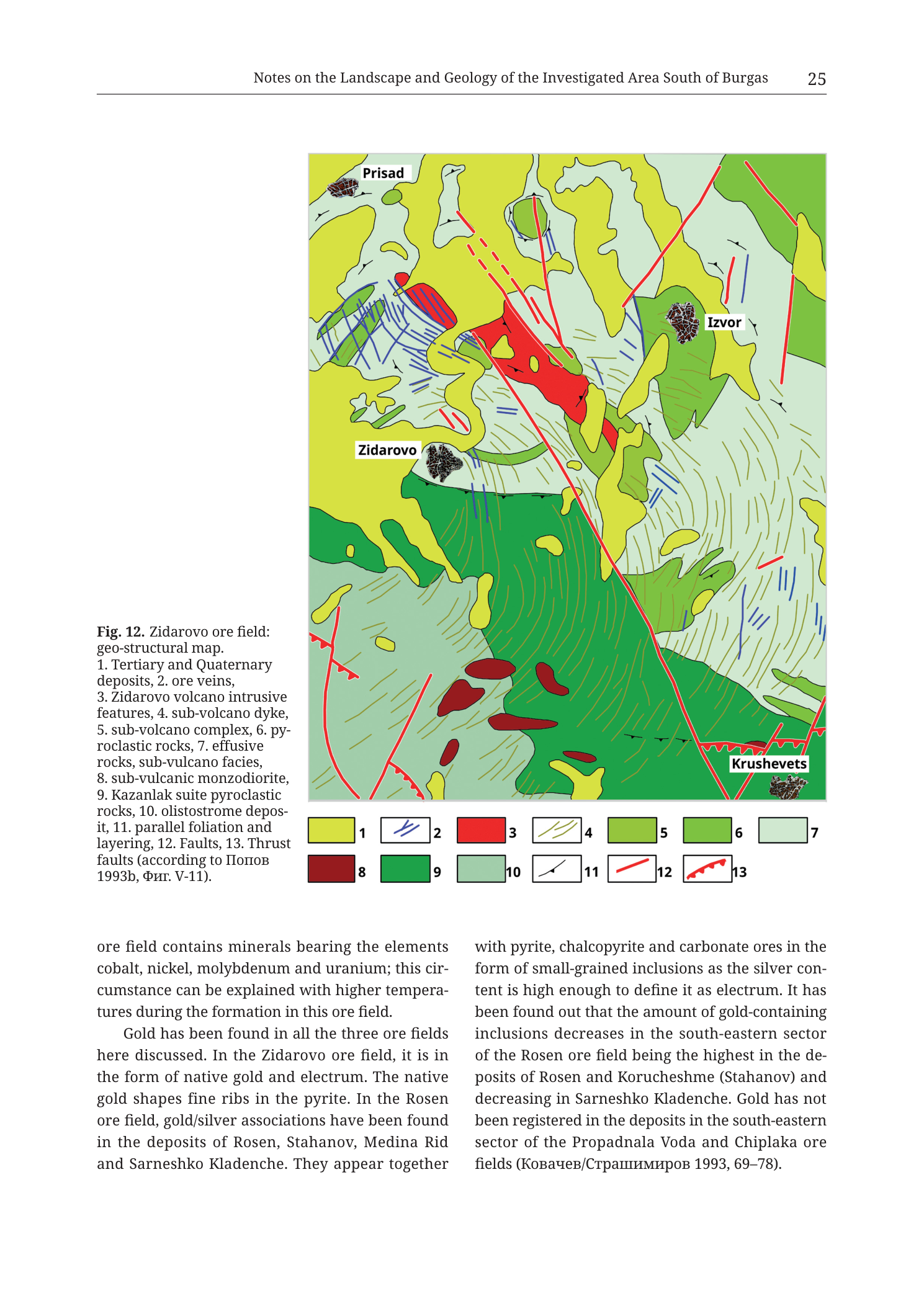
“Fig. 12. Zidarovo ore field: geo-structural map. 1. Tertiary and Quaternary deposits, 2. ore veins, 3. Zidarovo volcano intrusive features, 4. sub-volcano dyke, 5. sub-volcano complex, 6. pyroclastic rocks, 7. effusive rocks, sub-vulcano facies, 8. sub-vulcanic monzodiorite, 9. Kazanlak suite pyroclastic rocks, 10. olistostrome deposit, 11. parallel foliation and layering, 12. Faults, 13. Thrust faults (according to Попов 1993b, Фиг. V-11).”
Translation (citation only): Попов = Popov; Фиг. = Fig.
Map legend (bottom of map frame — numbered colour/symbol boxes, two rows)
Row 1:
- 1 — yellow square — Tertiary and Quaternary deposits
- 2 — blue line — ore veins
- 3 — solid red / scarlet square — Zidarovo volcano intrusive features
- 4 — thin green line — sub-volcano dyke
- 5 — medium bright green square — sub-volcano complex
- 6 — medium green square — pyroclastic rocks
- 7 — pale mint / light blue-green square — effusive rocks, sub-vulcano facies
Row 2:
- 8 — dark maroon / brown-red square — sub-vulcanic monzodiorite
- 9 — dark green square — Kazanlak suite pyroclastic rocks
- 10 — pale sage / grey-green square — olistostrome deposit
- 11 — black short tick / dip-tick symbol — parallel foliation and layering
- 12 — thin red line — Faults
- 13 — red line with teeth/triangles on one side — Thrust faults
Map-face place-name labels (white rounded rectangles)
- Prisad — upper-left (NW) of map, beside a dark monzodiorite (8) body
- Zidarovo — left-centre (west), beside the main settlement/cluster area on green and yellow units
- Izvor — upper-right (NE), beside a dark monzodiorite body and blue vein traces
- Krushevets — lower-right (SE), on pale green/yellow fringe
No coordinate grid numbers, scale bar, or north arrow printed on the map.
Map-face geological and structural geometry (as visible)
- Red intrusive body (3) — compact scarlet stock near the map centre, slightly north of mid-frame, elongating roughly E–W to NE–SW with irregular lobes; principal Zidarovo volcano intrusive feature.
- Dark maroon monzodiorite bodies (8) — several discrete dark red-brown stocks:
- cluster near Prisad (NW)
- body near Izvor (NE)
- multiple oval/elongate bodies in the southern green field (south of the main red stock), scattered through medium/dark green pyroclastic and Kazanlak units
- Green volcanic complex wrapping the intrusive cores:
- medium bright green (5 — sub-volcano complex) as internal green belts around and south of the red stock
- medium green (6 — pyroclastic rocks) interleaved
- dark green (9 — Kazanlak suite pyroclastic rocks) as a large dark-green domain occupying much of the southern half of the map, SW–SE of the red stock
- pale mint (7 — effusive rocks, sub-vulcano facies) in northern and fringe belts
- Pale sage olistostrome (10) — pale grey-green bands/patches interleaved notably in the north-central to NE area between the red stock and Izvor, and other limited strips.
- Yellow Tertiary–Quaternary (1) — extensive yellow cover in the northern half and as patches throughout, blanketing large areas around Prisad–Izvor and fringe zones; more cover than on the Varli Bryag Fig. 11 map.
- Blue ore veins (2) — numerous short blue linear traces:
- principal dense swarm in a NW–SE to NNW–SSE belt west and northwest of the red stock, in the Zidarovo–Prisad sector (green and yellow host)
- additional blue vein sets NE toward Izvor
- further blue traces SE of the red stock and in eastern green/yellow ground toward Krushevets
- overall preferred strike roughly NW–SE to N–S with local variation
- Green dyke lines (4) — thin green linear dykes cutting units, visible especially west and within volcanic packages.
- Red faults (12) — thin red fault traces, including:
- a major long, slightly curved to straight red fault running approximately NNW–SSE to N–S across nearly the full N–S length of the map, passing east of the red stock / through the central-eastern sector (dominant through-going structure)
- additional shorter red faults in the northern area (some dashed) near Prisad–Izvor, and in the SW
- red faults also in the far SW corner
- Thrust faults (13) — red lines with teeth; at least one clear toothed thrust trace segment associated with structural stacking (teeth indicating hangin-wall sense as drawn) — legended distinctly from ordinary faults.
- Black foliation/layering ticks (11) — short black ticks on green volcanic units around the intrusion and in southern Kazanlak pyroclastics; no numeric dip values printed.
- No lakes or sea on this map face (inland field SW of Mandra Lake / west of Rosen on the regional plate).
Body text on the same page (two columns beneath the figure)
Left column (continuation from previous page):
“ore field contains minerals bearing the elements cobalt, nickel, molybdenum and uranium; this circumstance can be explained with higher temperatures during the formation in this ore field.
Gold has been found in all the three ore fields here discussed. In the Zidarovo ore field, it is in the form of native gold and electrum. The native gold shapes fine ribs in the pyrite. In the Rosen ore field, gold/silver associations have been found in the deposits of Rosen, Stahanov, Medina Rid and Sarneshko Kladenche. They appear together“
Right column:
“with pyrite, chalcopyrite and carbonate ores in the form of small-grained inclusions as the silver content is high enough to define it as electrum. It has been found out that the amount of gold-containing inclusions decreases in the south-eastern sector of the Rosen ore field being the highest in the deposits of Rosen and Korucheshme (Stahanov) and decreasing in Sarneshko Kladenche. Gold has not been registered in the deposits in the south-eastern sector of the Propadnala Voda and Chiplaka ore fields (Ковачев/Страшимиров 1993, 69–78).”
Translation (citation only): Ковачев/Страшимиров = Kovachev/Strashimirov.
Description
TYPE & PURPOSE
This is a geo-structural map of the Zidarovo ore field, SE Bulgaria (Upper Cretaceous Burgas volcano-plutonic region), completing the three-field set with Rosen (Fig. 9) and Varli Bryag (Fig. 11) in Dimitrov’s chapter. Purpose: locate Zidarovo volcano intrusive features and satellite monzodiorite bodies against subvolcanic, pyroclastic (including Kazanlak suite), effusive, and olistostrome packages; show the blue ore-vein swarm and the red fault/thrust network that structure the field; and name the four settlement anchors — Prisad, Zidarovo, Izvor, Krushevets. Source: Popov 1993b, Fig. V-11. Body text on the preceding page (visible in part on Fig. 11’s PNG) stated >50 polymetallic Cu–Au veins, sectors Krushevets-Yurta, Krushevets, Zidarovo, Izvor and Parlena Kokoshka-Tepeto, vein lengths 100–300 m, and primary plus secondary mineralisation — this map is the spatial frame for that inventory.
FRAME, EXTENT, ORIENTATION
- Single rectangular map in the upper–middle of page 25; caption text block left of the map; numbered 1–13 legend strip under the map; two-column chapter body below.
- Orientation: north up (standard volume convention; settlement layout Prisad NW, Izvor NE, Zidarovo west-centre, Krushevets SE matches regional geography west of Rosen / south of Mandra Lake on Tub Fig. 8).
- Geographic extent: inland Zidarovo paleovolcanic centre and ore field around the named villages — the SW member of the Rosen–Varli Bryag–Zidarovo triad. No lake or Black Sea shoreline in-frame.
- No printed coordinate grid, UTM, lat/long, north arrow, or scale bar.
SCALE
- No scale bar or ratio scale printed.
- Earlier same-chapter text (page 24 continuation) gives individual ore-vein lengths of 100–300 m for this field — that is the only numeric linear scale cue tied to Fig. 12. Full map frame is multiple kilometres on a side (village-spacing scale).
COORDINATES / GRID
- None. Catalogue-style UTM centroid consistency check does not apply.
RELIEF & PHYSIOGRAPHY
- Planar geological colour map: no contours, hillshade, or elevation values.
- Physiography implied only by colour-belt geometry and the settlement pattern. Prior-page text assigns the Zidarovo volcano volcanogenic pile a thickness of about 2000–2500 m.
HYDROGRAPHY & COAST
- No lakes, rivers, or coastline drawn or labelled on this map.
ANTHROPOGENIC / CULTURAL FEATURES
Settlements labelled in white bubbles:
- Prisad — NW
- Zidarovo — west-centre (name-giving settlement of the field)
- Izvor — NE
- Krushevets — SE (text also names Krushevets-Yurta as a better-explored sub-sector with three ore-inserting faults and rib-like ore bodies)
No mine-pick symbols, shaft marks, roads, or buildings beyond the four name labels. Ore expressed as blue vein lines only.
GEOLOGICAL CONTENT — MAPPED UNITS (legend order 1–13)
- Tertiary and Quaternary deposits — yellow. Extensive northern and patchy regional cover; more widespread than on Varli Bryag Fig. 11.
- Ore veins — blue lines. Separate from red faults (unlike Varli Bryag’s combined red “ore veins and faults” key; closer to Rosen Fig. 9’s blue-vein convention).
- Zidarovo volcano intrusive features — solid red. Central scarlet stock — the main intrusive core of the Zidarovo volcano (gabbro/monzogabbro on the regional Tub Fig. 8 legend for “Zidarovo pluton”; undivided red here as “intrusive features”).
- Sub-volcano dyke — thin green lines. Magmatic feeder dykes distinct from blue veins and red faults.
- Sub-volcano complex — medium bright green. Part of the proximal green envelope of the system.
- Pyroclastic rocks — medium green. Interleaved pyroclastic packages of the Zidarovo volcano.
- Effusive rocks, sub-vulcano facies — pale mint green. Effusive / subvolcanic-facies rocks, often more peripheral or northern.
- Sub-vulcanic monzodiorite — dark maroon. Multiple discrete subvolcanic monzodiorite bodies (Prisad, Izvor, and several southern stocks in the Kazanlak/pyroclastic domain) — a distinctive intrusive satellite suite not broken out on the simpler Varli Bryag or Rosen chapter maps.
- Kazanlak suite pyroclastic rocks — dark green. Large southern domain of Kazanlak suite pyroclastics SW–SE of the main red stock — major map-forming unit of the southern half.
- Olistostrome deposit — pale sage grey-green. Olistostrome bands notably north-central/NE between the red stock and Izvor; mass-transport deposits in the volcano-sedimentary pile.
- Parallel foliation and layering — black ticks on stratified volcanic units.
- Faults — thin red lines (tectonic faults without ore-vein blue ornament).
- Thrust faults — red lines with teeth on one side — contractional structures explicitly keyed, unique to this figure among the three chapter ore-field maps.
STRUCTURAL SYMBOLS
- Blue ore-vein swarm (2): densest west/NW of the central red stock in the Zidarovo–Prisad corridor, with additional sets near Izvor and toward Krushevets. Preferred NW–SE to N–S strikes. Matches text sectors Krushevets-Yurta / Krushevets / Zidarovo / Izvor (/ Parlena Kokoshka-Tepeto — last not labelled on map).
- Red faults (12): a long, continuous, roughly N–S to NNW–SSE through-going fault dominates the eastern half of the map (east of the red stock). Shorter red faults mesh with the northern and SW areas; some northern faults appear dashed.
- Thrust faults (13): toothed red traces record thrust stacking — important structural overprint beyond simple normal/strike faulting; distinguishes Zidarovo’s geo-structural portrait from the two sister maps.
- Green dykes (4): second linear magmatic set cutting host rocks.
- Foliation ticks (11): layering/foliation fabric in green units about the intrusion and in southern pyroclastics.
- No offshore submerged-volcano dashed arcs (inland field).
ORE BODIES / DEPOSITS
- Cartographic ore = blue vein lines (2) clustered by sector around Prisad, Zidarovo, Izvor, and Krushevets.
- No numbered veins or crossed-picks mine symbols; no individual vein names on the map.
- From same-chapter prose (prior page + this page’s gold discussion):
-
50 polymetallic veins; Cu and Au most valuable metals
- vein lengths 100–300 m; rib-like ore bodies at better-explored Krushevets-Yurta (three ore-inserting faults)
- primary and secondary ore mineralisation from intensive hydrothermal action
- Zidarovo gold as native gold and electrum; native gold as fine ribs in pyrite
- higher-T signature vs other fields reflected in Co, Ni, Mo, U pure-field minerals (continuation sentence opening this page — attached to Rosen in the running text’s “this ore field” thread for Co-Ni-Mo-U, while gold-form details explicitly split by field)
-
- Rosen deposit name chain appears in the gold paragraph on this page (Rosen, Stahanov/Korucheshme, Medina Rid [= Meden Rid], Sarneshko Kladenche; gold absent at SE Propadnala Voda and Chiplaka) — comparative mineralogy, not Zidarovo map labels.
SAMPLE / LOCALITY POINTS
- None beyond the four settlement name labels.
CROSS-SECTION TRACES
- None on this map. Regional Cross-section I-I on Tub Fig. 8 starts in the Zidarovo caldera (S end) and runs toward Meden rid / Sozopol caldera.
COLOUR & SYMBOL SYSTEM
- Red fill (3) = main Zidarovo intrusive features.
- Maroon fill (8) = subvolcanic monzodiorite satellites.
- Green ladder (5, 6, 7, 9) = subvolcano complex / pyroclastics / effusive–subvolcano facies / Kazanlak suite pyroclastics.
- Pale sage (10) = olistostrome.
- Yellow (1) = Tertiary + Quaternary cover.
- Blue lines (2) = ore veins; green lines (4) = dykes; red lines (12) = faults; toothed red (13) = thrusts; black ticks (11) = foliation/layering.
- Three line colours for three structural/ magmatic classes isolate veins from faults more cleanly than Varli Bryag Fig. 11.
SPATIAL RELATIONSHIPS
- Core: central red Zidarovo intrusive stock, ringed and underlain/flanked by green subvolcanic–pyroclastic–effusive packages, with a large dark-green Kazanlak suite domain dominating the south.
- Satellites: maroon monzodiorite bodies at Prisad, Izvor, and in the southern pyroclastic field — distributed intrusive centres, not a single stock-only geometry.
- Ore corridors: blue veins concentrate in village-named sectors — especially the Zidarovo–Prisad belt west/NW of the red stock and secondary sets at Izvor and toward Krushevets — matching the textual sector list.
- Master fault: long N–S red fault east of the stock partitions the field and likely localises or truncates structures on the eastern side.
- Thrusts: toothed red structures add a contractional component to the post-magmatic tectonic history that hosts veins.
- Cover: yellow Tertiary–Quaternary blanketing in the north partially conceals older volcanic fabric around Prisad–Izvor.
- Olistostrome: pale sage mass-flow deposits in the north-central belt record unstable volcano-sedimentary deposition between the stock and Izvor.
- Regional triad position: Zidarovo is the SW inland field; engages Rosen volcano rocks from the west/SW (stated on Rosen Fig. 9 page text) and sits near Varli Bryag to the north on the regional Tub Fig. 8 mosaic. Mineralogy text treats Zidarovo together with Rosen and Varli Bryag (shared Bi; Se/Te with Varli Bryag; gold forms distinctive here as native gold ribs in pyrite plus electrum).
RELATIONSHIP TO OTHER FIGURES
- Fig. 12 in the “Notes on the Landscape and Geology…” chapter (Dimitrov), Krauss et al. 2020, printed page 25.
- Source: Popov 1993b, Фиг. V-11.
- Explicitly cross-referenced on the previous page as “(fig. 12)” for Zidarovo vein lengths 100–300 m.
- Companions:
- Tub_p023_Fig8 — regional paleovolcano map + Cross-section I-I through Zidarovo caldera.
- Tub_p024_Fig9 — Rosen geo-structural map.
- Tub_p026_Fig11 — Varli Bryag geo-structural map.
- Catalogue site plates for Izvor-area / regional settlements elsewhere in the monograph.
- Same-page body text continues the three-field gold mineralogy synthesis (Kovachev/Strashimirov 1993).
Consistency Check
- Not applicable: no UTM centroid and no map-axis coordinates printed.
Notes
- Filename Tub_p027 vs printed header page 25: PDF vs book pagination difference; content identity is Fig. 12.
- No north arrow, scale bar, or coordinate grid; orientation from labelled settlements + regional convention.
- Caption/legend orthography retained: “sub-volcano”, “sub-vulcano”, “sub-vulcanic”, “Zidarovo”, “Kazanlak”, “olistostrome deposit”.
- “Medina Rid” in the body text is the printed form for Meden Rid / Medni Rid; “Sarneshko Kladenche” / “Korucheshme (Stahanov)” / “Propadnala Voda” / “Chiplaka” appear in the comparative Rosen gold paragraph, not as labels on the Zidarovo map.
- Thrust-fault teeth direction (which side is hanging wall) is recorded as drawn; sense should be read from the printed asymmetric teeth ornament on the plate.
- Major long N–S red fault is the most continuous single structure on the map; described from visible geometry.
- Left-column opening sentence continues from the prior page (Co–Ni–Mo–U / higher-T thread attached to “this ore field” — Rosen in the running mineralogy argument); gold forms for Zidarovo are explicitly named in the following sentences.
- None further.