Description
Transcription
Page header
- Page number (upper left): 24
- Running author head: “Kalin Dimitrov”
Figure caption (right of map)
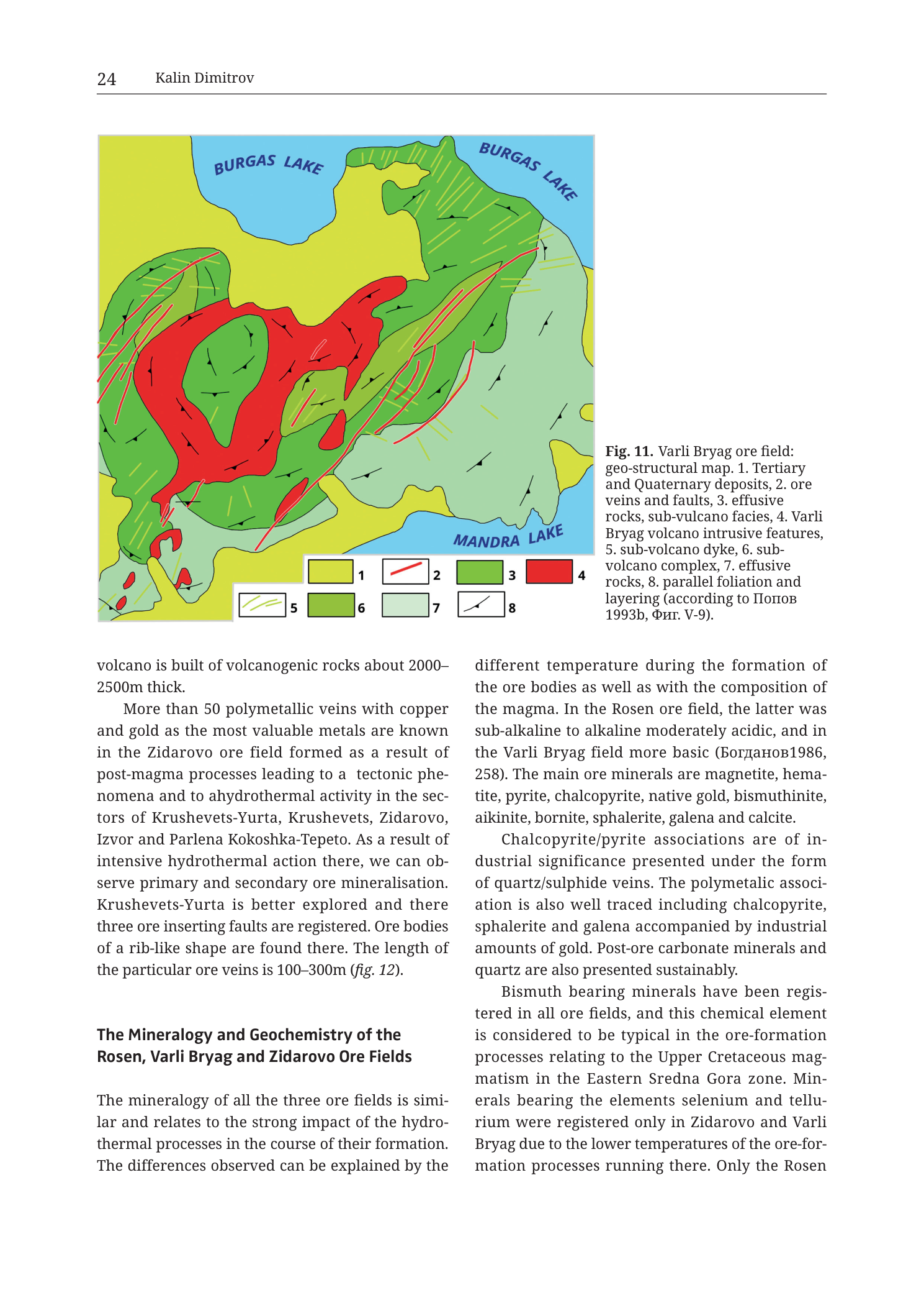
“Fig. 11. Varli Bryag ore field: geo-structural map. 1. Tertiary and Quaternary deposits, 2. ore veins and faults, 3. effusive rocks, sub-vulcano facies, 4. Varli Bryag volcano intrusive features, 5. sub-volcano dyke, 6. sub-volcano complex, 7. effusive rocks, 8. parallel foliation and layering (according to Попов 1993b, Фиг. V-9).”
Translation (citation only): Попов = Popov; Фиг. = Fig.
Map legend (bottom-centre of map frame — numbered colour/symbol boxes)
- 1 — yellow square — Tertiary and Quaternary deposits
- 2 — red line — ore veins and faults
- 3 — medium bright green square — effusive rocks, sub-vulcano facies
- 4 — solid red / scarlet square — Varli Bryag volcano intrusive features
- 5 — thin green line — sub-volcano dyke
- 6 — darker / medium-dark green square — sub-volcano complex
- 7 — pale mint / light blue-green square — effusive rocks
- 8 — black short tick / dip-tick symbol — parallel foliation and layering
Map-face geographic labels
- BURGAS LAKE — printed twice along the northern water body (left and right segments of the lake label), blue uppercase text on pale blue water fill
- MANDRA LAKE — printed in the SE sector on pale blue water fill, blue uppercase text
No settlement names, deposit names, mine names, or coordinate numbers are printed on the map face.
Map-face structural overprint (visible geometry)
- Large central-to-western red intrusive body (legend 4 — Varli Bryag volcano intrusive features): irregular, multi-lobed red mass elongated roughly E–W to WNW–ESE, with arms extending west, a southern bulge, and a NE-pointing lobe. Dominant red core of the field.
- Green volcanic envelopes wrap the red intrusion:
- medium bright green (3 — effusive / sub-vulcano facies) forming thick rings and patches around the red body, especially west, south, and east
- darker green (6 — sub-volcano complex) as large lobes notably SW and SE of the red core and other outer patches
- pale mint green (7 — effusive rocks) in more peripheral strips, including NE and SE fringes toward the lakes
- Yellow (1) Tertiary–Quaternary cover: limited yellow patches/frames along outer/SE and fringe positions (small bodies; young cover is subordinate on this map compared with volcanic/intrusive colours).
- Red lines (2) ore veins and faults: numerous thin red linear traces.
- Dense cluster of short, subparallel NW–SE to WNW–ESE red traces cut through the western and central red intrusive body and its immediate green envelope — the principal vein swarm of the Varli Bryag field.
- Longer red fault/vein lines traverse green rocks east and NE of the intrusion (one prominent long red line runs roughly SW–NE to ENE across green units toward Burgas Lake).
- Additional red traces on the southern and western flanks of the green envelope.
- Small isolated red lensoid/pod bodies SW of the main intrusion (small red patches separate from the main stock).
- Green dyke lines (5): thin green linear traces (sub-volcano dykes) cutting across units, visible especially west and within green complexes, trending various directions including rough NW–SE and N–S segments.
- Black foliation/layering ticks (8): short black strike-ticks scattered across green effusive and subvolcano units around the intrusion, recording parallel foliation and layering; no numeric dip values printed beside ticks.
- Hydrography: pale blue water fills for Burgas Lake (north, large irregular lake polygon split or labelled in two segments) and Mandra Lake (SE). Land–water contacts drawn as simple colour boundaries.
Body text on the same page (two columns beneath the figure)
Left column (continuation from previous page + new section):
[continuation at top of left column:]
“volcano is built of volcanogenic rocks about 2000–2500m thick.
More than 50 polymetallic veins with copper and gold as the most valuable metals are known in the Zidarovo ore field formed as a result of post-magma processes leading to a tectonic phenomena and to a hydrothermal activity in the sectors of Krushevets-Yurta, Krushevets, Zidarovo, Izvor and Parlena Kokoshka-Tepeto. As a result of intensive hydrothermal action there, we can observe primary and secondary ore mineralisation. Krushevets-Yurta is better explored and there three ore inserting faults are registered. Ore bodies of a rib-like shape are found there. The length of the particular ore veins is 100–300m (fig. 12).“
Section heading (left column, lower half):
“The Mineralogy and Geochemistry of the Rosen, Varli Bryag and Zidarovo Ore Fields”
Left-column body under that heading:
“The mineralogy of all the three ore fields is similar and relates to the strong impact of the hydrothermal processes in the course of their formation. The differences observed can be explained by the”
Right column (continues the mineralogy section and preceding comparative prose):
“different temperature during the formation of the ore bodies as well as with the composition of the magma. In the Rosen ore field, the latter was sub-alkaline to alkaline moderately acidic, and in the Varli Bryag field more basic (Богданов1986, 258). The main ore minerals are magnetite, hematite, pyrite, chalcopyrite, native gold, bismuthinite, aikinite, bornite, sphalerite, galena and calcite.
Chalcopyrite/pyrite associations are of industrial significance presented under the form of quartz/sulphide veins. The polymetalic association is also well traced including chalcopyrite, sphalerite and galena accompanied by industrial amounts of gold. Post-ore carbonate minerals and quartz are also presented sustainably.
Bismuth bearing minerals have been registered in all ore fields, and this chemical element is considered to be typical in the ore-formation processes relating to the Upper Cretaceous magmatism in the Eastern Sredna Gora zone. Minerals bearing the elements selenium and tellurium were registered only in Zidarovo and Varli Bryag due to the lower temperatures of the ore-formation processes running there. Only the Rosen“
[text cuts off mid-sentence at page end — continues on following page, not in this PNG.]
Description
TYPE & PURPOSE
This is a geo-structural map of the Varli Bryag ore field (also spelled Varli Bryag / Varlibrayag), SE Bulgaria, in the Burgas volcano-plutonic region west/southwest of the Rosen field. Purpose: show the Varli Bryag intrusive core, its effusive and subvolcanic green envelopes, the red ore-vein/fault network, subvolcano dykes, parallel foliation/layering, and the field’s position between Burgas Lake (north) and Mandra Lake (southeast). It is the Varli Bryag counterpart to the Rosen geo-structural map (Fig. 9 in the same chapter). Source: Popov 1993b, Fig. V-9.
FRAME, EXTENT, ORIENTATION
- Single rectangular map occupying the upper portion of page 24; numbered legend strip along the bottom edge of the map; caption text block to the right of the map; two-column chapter body below.
- Orientation: north up (Burgas Lake along the top edge, Mandra Lake at lower right — standard local geography south of Burgas).
- Geographic extent: the land bridge / hill country between Burgas Lake (N) and Mandra Lake (SE), i.e. the Varli Bryag paleovolcanic centre area inland west of the Medni Rid–Rosen coastal field. Matches the NW sector of the regional paleovolcano plate (Tub Fig. 8), where Varli Bryag / Cherni vrah sits north of Mandra Lake.
- No printed coordinate grid, UTM, lat/long, north arrow, or scale bar.
SCALE
- No scale bar and no ratio scale printed.
- Absolute distances not readable from the plate alone. Body text on adjacent pages (and Fig. 12 for Zidarovo) gives vein lengths of 100–300 m in the neighbouring Zidarovo field; Varli Bryag vein swarm on this map is schematic at field scale (kilometre-order frame by lake-to-lake geography).
COORDINATES / GRID
- None. Catalogue-style UTM centroid consistency check does not apply.
RELIEF & PHYSIOGRAPHY
- Planar geological colour map: no contours, hillshade, or elevation tints.
- Physiography implied by the two large lakes framing the north and southeast sides and by the compact volcanic–intrusive colour mass between them.
- Body text (continuation paragraph, referring to the volcano under discussion on the prior page — Zidarovo in that paragraph’s immediate thread, with thickness 2000–2500 m) is about the neighbouring Zidarovo volcano pile, not a thickness printed for Varli Bryag on this map.
HYDROGRAPHY & COAST
- Burgas Lake — large pale-blue water body along the entire northern map edge; label printed in two places (“BURGAS LAKE” left and right).
- Mandra Lake — pale-blue water body occupying the southeast corner; label “MANDRA LAKE”.
- No rivers labeled; no Black Sea coastline on this map (the field is inland, lake-bounded rather than seaboard).
- Land–lake contacts are smooth to gently embayed colour boundaries.
ANTHROPOGENIC / CULTURAL FEATURES
- None drawn (no settlement dots, mine-pick symbols, roads, or buildings).
- No named mines or vein numbers on the map face. Ore is shown only as the red line swarm (legend 2).
GEOLOGICAL CONTENT — MAPPED UNITS (legend order 1–8)
- Tertiary and Quaternary deposits — yellow. Minor yellow patches at outer/fringe positions (limited cover compared with the volcanic/intrusive bulk of the map).
- Ore veins and faults — red lines. Combined symbol for both structures (unlike Rosen Fig. 9, which separated red faults from blue ore veins). On this plate, mineralised structures and faults share the single red linear symbol.
- Effusive rocks, sub-vulcano facies — medium bright green. Major carapace unit wrapping much of the red intrusion; forms broad green masses west, south, and east of the red core.
- Varli Bryag volcano intrusive features — solid red. The dominant central intrusive stock/complex — multi-lobed scarlet body occupying the map centre-west. Equals the Varlibrayag pluton of the regional Fig. 8 plate (quartz-syenite / syenite / monzonite suite there; undivided red here). Small satellite red pods occur SW of the main body.
- Sub-volcano dyke — thin green linear traces. Dykes cutting volcanic and possibly intrusive host rocks; distinct from the red vein/fault set by colour (green vs red).
- Sub-volcano complex — darker green fill. Large dark-green lobes especially on the SW and parts of the SE perimeter of the system; represents subvolcanic complex rocks of the Varli Bryag centre.
- Effusive rocks — pale mint / light green. More distal or different-facies effusive packages at NE and outer fringes toward the lakes.
- Parallel foliation and layering — black short tick marks on green units around the intrusion.
STRUCTURAL SYMBOLS & ORE GEOMETRY
- Red vein/fault swarm: centre of mineralisation is the dense set of short, subparallel red traces cutting the western and central parts of the red intrusion and its green contact zone. Preferred strike appears NW–SE to WNW–ESE — ridge/contact-parallel fabric analogous to the Medni Rid vein belt of the Rosen field, but here hosted in/against the Varli Bryag intrusive core between the two lakes.
- Longer red structures extend into green rocks east of the stock (one long roughly ENE-trending line toward Burgas Lake), indicating structural continuity beyond the main stock.
- Green dykes (5) add a second linear population (subvolcanic feeders) distinct from ore veins/faults.
- Foliation ticks (8) document layered/foliated fabric in the volcanic envelope, generally following the circumferential green belts around the intrusion.
- No concentric offshore dashed arcs (unlike Rosen Fig. 9) — this field is fully inland between lakes.
- No keyed caldera-fault double-line symbol here; caldera geometry for Varli Bryag is shown instead on the regional cross-section II-II of Tub Fig. 8.
ORE BODIES / DEPOSITS
- Cartographic expression of ore = the red line swarm (2) clustered on the intrusive body and contact.
- No individual named deposits or numbered veins appear on the map.
- Same-page body text focuses mineral inventory comparatively across all three fields rather than listing Varli Bryag vein counts on this page. Mineral list given for the three fields collectively:
- magnetite, hematite, pyrite, chalcopyrite, native gold, bismuthinite, aikinite, bornite, sphalerite, galena, calcite
- Industrial: chalcopyrite/pyrite as quartz/sulphide veins; polymetallic chalcopyrite–sphalerite–galena with industrial gold; post-ore carbonates and quartz
- Bi minerals in all three fields (typical of Upper Cretaceous Eastern Sredna Gora ore formation)
- Se- and Te-bearing minerals registered in Zidarovo and Varli Bryag only (lower ore-formation temperatures than Rosen)
- Magma contrast: Rosen sub-alkaline to alkaline moderately acidic; Varli Bryag more basic (Bogdanov 1986, 258)
- Neighbouring Zidarovo text on the same page (continuation): >50 polymetallic Cu–Au veins; sectors Krushevets-Yurta, Krushevets, Zidarovo, Izvor, Parlena Kokoshka-Tepeto; vein lengths 100–300 m (fig. 12) — that inventory belongs to Zidarovo (Fig. 12), not Varli Bryag, but sits on this page as prior-section spillover.
SAMPLE / LOCALITY POINTS
- None.
CROSS-SECTION TRACES
- None on this map. Regional Cross-section II-II on Tub Fig. 8 cuts SW–NE through the Varli Bryag caldera and shows the red plutonic core with flanking faults.
COLOUR & SYMBOL SYSTEM
- Red fill = Varli Bryag intrusive features (pluton/stock).
- Green family (bright 3 / dark 6 / pale 7) = effusive and subvolcanic carapace facies ladder.
- Yellow = Tertiary + Quaternary cover (minor).
- Pale blue = lake water.
- Red lines = ore veins and faults (combined).
- Green lines = subvolcano dykes.
- Black ticks = parallel foliation and layering.
- Legend is numbered 1–8 with small colour/symbol boxes under the map; caption repeats the numbered list in prose.
SPATIAL RELATIONSHIPS
- Core–carapace: red Varli Bryag intrusive stock sits at the centre of a green effusive/subvolcanic envelope between Burgas Lake (N) and Mandra Lake (SE).
- Ore control: red vein/fault traces concentrate on the intrusion and its immediate green contact — mineralisation is intrusion-centred / contact-proximal, analogous in role to the SW Medni Rid vein belt of Rosen Fig. 9, though here the host is the Varli Bryag stock itself between the lakes rather than a coastal pluton–tuff corridor.
- Lake frame: Burgas Lake truncates/fringes the north side of the volcanic edifice; Mandra Lake bounds the SE — the ore field is the lakes’ intervening volcanic-intrusive high.
- Facies zoning: darker subvolcano complex (6) and bright subvolcano-facies effusives (3) hug the stock; paler effusives (7) prefer outer/NE positions; yellow cover is patchy and peripheral.
- Dykes vs veins: green dykes (magmatic feeders) vs red veins/faults (structural/mineralised) give two lineament populations.
- Regional triad: with Rosen (Fig. 9, coastal SE) and Zidarovo (Fig. 12, SW), this map completes the three adjacent Upper Cretaceous paleovolcano–ore fields of the Dimitrov chapter; mineralogy section on this page treats all three together and flags Varli Bryag’s more basic magma and lower-T Se/Te mineral signature shared with Zidarovo.
RELATIONSHIP TO OTHER FIGURES
- Fig. 11 in Kalin Dimitrov’s chapter, Krauss et al. 2020 (Tübingen), printed page 24.
- Source map: Popov 1993b, Фиг. V-9.
- Companions in this collection:
- Tub_p023_Fig8 — regional Rosen / Varli Bryag / Zidarovo paleovolcano map + cross-sections (II-II through Varli Bryag).
- Tub_p024_Fig9 — Rosen ore field geo-structural map (parallel figure type).
- Tub_p027_Fig12 — Zidarovo ore field map (explicitly cross-referenced as fig. 12 in the left-column text for Zidarovo vein lengths).
- Tub_p305_Fig8 — later detailed Varli Bryag vein cross-section in the monograph.
- Same-page text transitions from end of Zidarovo description into the three-field mineralogy/geochemistry synthesis.
Consistency Check
- Not applicable: no UTM centroid and no map-axis coordinates printed.
Notes
- Filename Tub_p026 vs printed header page 24: PDF vs book pagination difference; content identity is Fig. 11.
- No north arrow, scale bar, or coordinate grid; orientation from lake geography (Burgas Lake north, Mandra Lake SE).
- Legend item 2 merges “ore veins and faults” into one red-line symbol — unlike Rosen Fig. 9’s separate red-fault / blue-vein key. Do not assume every red line is ore-grade; the key presents them jointly.
- Caption orthography retained: “sub-vulcano”, “Varli Bryag”, “Попов”, “Фиг.”.
- In-text citation “Богданов1986” lacks a space before the year as printed.
- Left-column continuation at page top discusses Zidarovo volcano thickness and Zidarovo veins (fig. 12) — spillover from the previous section, not Varli Bryag map annotation.
- Right-column text ends mid-sentence (“Only the Rosen”) at page break.
- Small isolated red pods SW of the main stock are visible; treated as satellite intrusive features (legend 4) rather than separate named bodies.
- None further.