Description
Transcription
Page header
- Page number (upper left): 22
- Running author head: “Kalin Dimitrov”
Figure caption (directly under map)
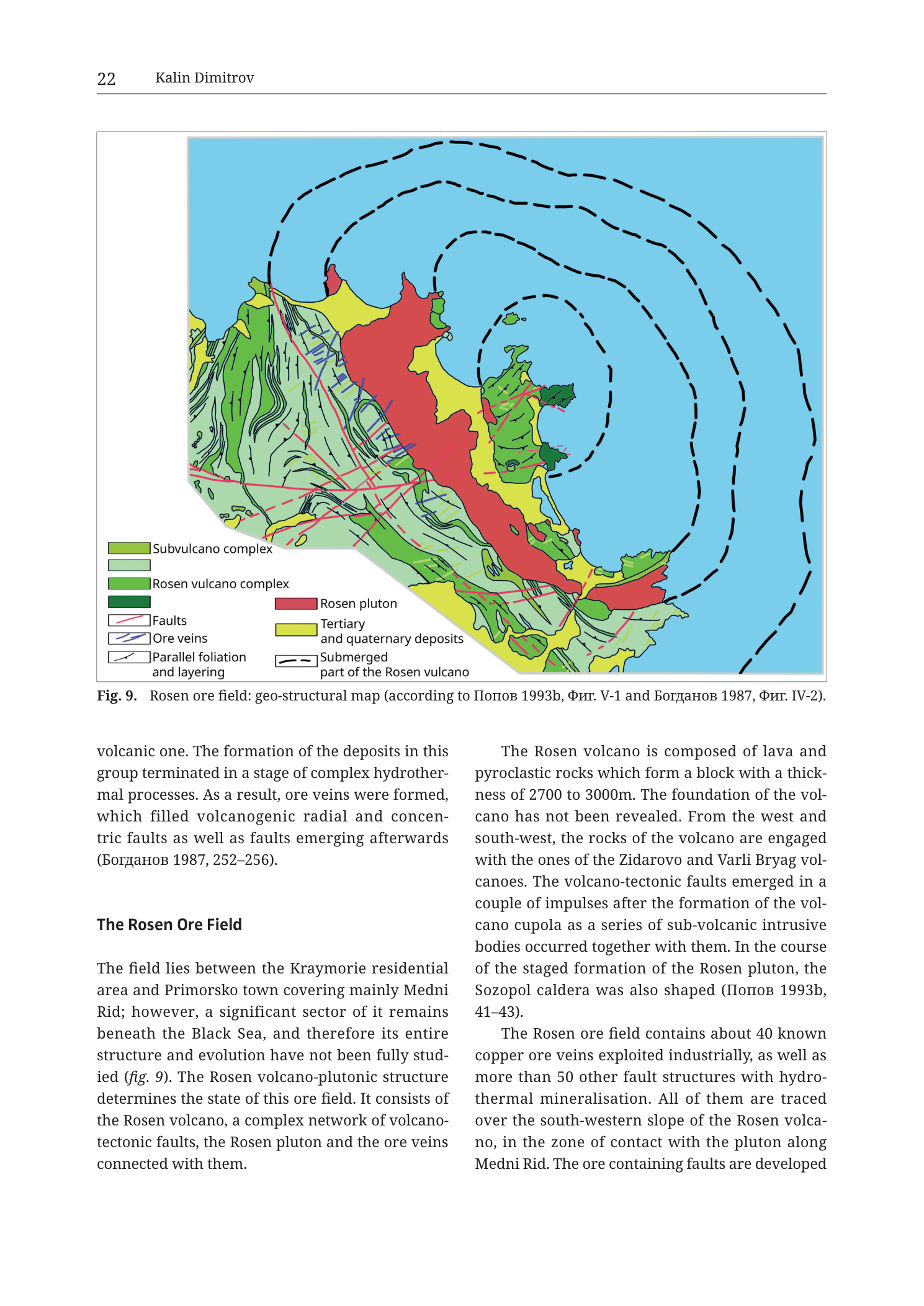
“Fig. 9. Rosen ore field: geo-structural map (according to Попов 1993b, Фиг. V-1 and Богданов 1987, Фиг. IV-2).”
Translation (citation names/abbr. only): Попов = Popov; Богданов = Bogdanov; Фиг. = Fig.
Map legend (lower-left of map frame, reading roughly top→bottom / left→right as printed)
- ■ (medium olive-green) — Subvulcano complex
- ■ (pale / light mint green) — (unlabelled separate swatch stacked under Subvulcano; part of the green complex ladder — see Notes)
- ■ (medium bright green) — Rosen vulcano complex
- ■ (dark green) — (darkest green swatch in the vertical green stack under Rosen vulcano complex)
- red single line — Faults
- blue single line — Ore veins
- black short tick / dip-tick symbol — Parallel foliation and layering
- ■ (solid red / scarlet) — Rosen pluton
- ■ (yellow) — Tertiary and quaternary deposits
- black dashed thick line — Submerged part of the Rosen vulcano
Map-face content (no place-name labels printed on the map body)
- No settlement names, deposit names, cape names, or coordinate grid numbers are printed on the coloured map itself.
- Structural overprint (visible):
- Dense swarm of thin blue lines (ore veins) concentrated in a NW–SE belt on the south-western / left-central flank of the red Rosen pluton, pressing against the pluton contact; veins trend predominantly NW–SE with some N–S and cross-cutting strands.
- Red fault lines cutting through green volcanic complexes and across/along the pluton margin; several faults trend NW–SE parallel to the vein swarm; additional faults trend nearer N–S or NE–SW, producing a cross-cutting network especially west and south-west of the pluton.
- Black short foliation/layering ticks scattered across green units, recording parallel foliation and layering attitudes (tick marks without numeric dip labels on this figure).
- Concentric black dashed arcs (four visible nested arcs) in the light-blue sea area NE of the landmass — legend: “Submerged part of the Rosen vulcano”. Arcs are concave toward the land / centred approximately NE of the red pluton’s coastal end, stepping offshore into the blue field.
- Land/sea: pale blue = sea (Black Sea); solid black coastline with a jagged NW–SE coastal outline and a large eastern bay/indent; the red pluton reaches the coast at a blunt headland; yellow Tertiary–Quaternary patches along parts of the shoreline and low areas.
Body text on the same page (two columns beneath the figure)
Left column (continues from previous page, then new section):
[continuation paragraph, top of left column:]
“volcanic one. The formation of the deposits in this group terminated in a stage of complex hydrothermal processes. As a result, ore veins were formed, which filled volcanogenic radial and concentric faults as well as faults emerging afterwards (Богданов 1987, 252–256).”
Section heading:
“The Rosen Ore Field”
Left-column body:
“The field lies between the Kraymorie residential area and Primorsko town covering mainly Medni Rid; however, a significant sector of it remains beneath the Black Sea, and therefore its entire structure and evolution have not been fully studied (fig. 9). The Rosen volcano-plutonic structure determines the state of this ore field. It consists of the Rosen volcano, a complex network of volcano-tectonic faults, the Rosen pluton and the ore veins connected with them.”
Right column:
“The Rosen volcano is composed of lava and pyroclastic rocks which form a block with a thickness of 2700 to 3000m. The foundation of the volcano has not been revealed. From the west and south-west, the rocks of the volcano are engaged with the ones of the Zidarovo and Varli Bryag volcanoes. The volcano-tectonic faults emerged in a couple of impulses after the formation of the volcano cupola as a series of sub-volcanic intrusive bodies occurred together with them. In the course of the staged formation of the Rosen pluton, the Sozopol caldera was also shaped (Попов 1993b, 41–43).
The Rosen ore field contains about 40 known copper ore veins exploited industrially, as well as more than 50 other fault structures with hydrothermal mineralisation. All of them are traced over the south-western slope of the Rosen volcano, in the zone of contact with the pluton along Medni Rid. The ore containing faults are developed“
[text cuts off mid-sentence at page end — continues on following page, not in this PNG.]
Description
TYPE & PURPOSE
This is a geo-structural map of the Rosen ore field (SE Bulgaria, Medni Rid / Black Sea coast south of Burgas). It is a simplified structural–lithological sketch whose purpose is to show:
- the Rosen pluton as the red core of the volcano-plutonic centre;
- the Rosen volcano complex and subvolcano complex as concentric/adjacent green envelopes;
- the dense NW–SE ore-vein swarm (blue) on the south-western contact of the pluton (Medni Rid corridor);
- the fault network (red) that hosts and frames those veins;
- the offshore continuation of the Rosen volcano as concentric dashed arcs under the Black Sea;
- young yellow Tertiary–Quaternary cover along the coast.
The figure directly illustrates the body-text claim that a significant sector of the ore field lies beneath the Black Sea and that industrial copper veins cluster on the SW slope of the Rosen volcano at the pluton contact along Medni Rid. Sources cited in the caption: Popov 1993b (Фиг. V-1) and Bogdanov 1987 (Фиг. IV-2).
FRAME, EXTENT, ORIENTATION
- Single rectangular map frame occupying the upper half of page 22; legend inset lower-left inside/against the frame; caption beneath the frame; two-column chapter text below.
- Orientation: north is up (not labelled with an N-arrow on this crop, but coastline geometry and the standard Burgas-coast configuration plus concentric offshore arcs NE of the land match the conventional north-up coastal map of the Sozopol–Medni Rid area used elsewhere in the volume).
- Geographic extent (from body text + coastline shape): between Kraymorie (NW coastal residential area) and Primorsko (south), covering mainly Medni Rid, with substantial map area as light-blue sea to the NE/E. The landmass is a NW–SE elongated coastal block with a large eastern embayment and a headland where the red pluton meets the sea — the classic Rosen/Sozopol coastal configuration.
- No printed coordinate grid, projection name, lat/long, or UTM ticks.
SCALE
- No scale bar and no ratio scale (1:x) are printed on this figure.
- Absolute distances cannot be read directly from the plate; scale is qualitative. Regional context from companion figures and body text places the onshore Medni Rid ore corridor at several kilometres length (order-of-magnitude only).
COORDINATES / GRID
- None. Catalogue-style UTM centroid consistency check does not apply to this figure (no centroid printed on this page either).
RELIEF & PHYSIOGRAPHY
- No contours, hillshade, or elevation tints. Physiography is implied only by:
- Black Sea (uniform light blue) occupying the NE/E majority of the frame;
- irregular black coastline;
- landward colour belts elongated NW–SE (ridge-parallel fabric of Medni Rid);
- yellow lowland/coastal cover patches.
- Body text supplies the only thickness figure: Rosen volcano lava + pyroclastic pile forms a block 2700–3000 m thick (foundation not revealed).
HYDROGRAPHY & COAST
- Black Sea: large light-blue field, right and upper-right of the landmass.
- Coastline drawn as a continuous black shoreline with bays and headlands; no named rivers, lakes, or capes printed on the map face.
- A large eastern coastal embayment indents the green volcanic rocks and yellow cover southeast of the red pluton’s coastal termination.
- Concentric black dashed arcs in the sea mark the submerged part of the Rosen volcano — four nested dashed rings expanding offshore, centre roughly NE of the pluton’s seaward end / under the embayment approach. This is the map’s explicit statement that the volcano (and by the text, part of the ore field) continues under water.
ANTHROPOGENIC / CULTURAL FEATURES
- None drawn as map symbols (no settlement dots, mine picks, roads, or buildings).
- Body text supplies the geographic brackets: Kraymorie residential area, Primorsko town, and the ridge name Medni Rid. The industrial mining inventory is given in prose (~40 exploited copper ore veins; >50 other mineralised fault structures), not as labelled points on the map.
GEOLOGICAL CONTENT — MAPPED UNITS (legend order / colour system)
- Subvulcano complex — medium olive-green. Forms substantial areas on the western and outer parts of the onshore colour mosaic, including large left-side polygons and patches interleaved with brighter green Rosen volcano rocks. Represents subvolcanic intrusive / subvolcano facies of the Rosen system (as keyed).
- Rosen vulcano complex — bright to dark green stack (legend shows a multi-tone green ladder under this label). Dominates the central and coastal volcanic envelope around and SW of the red pluton; also builds much of the land SE of the pluton toward the large embayment. Equals the lava + pyroclastic carapace described in the text (2700–3000 m thick block).
- Rosen pluton — solid scarlet / red. A large, irregularly lobate body occupying the centre-to-NE of the onshore map, elongated roughly N–S to NW–SE, with a broad contact against green volcano rocks on its south-western side (the Medni Rid ore corridor) and a seaward margin on the NE where it meets the Black Sea. This is the dual-phase intermediate–felsic pluton of the Rosen volcano-plutonic centre (quartz-syenite/syenite/monzonite suite on other figures; not subdivided here).
- Tertiary and quaternary deposits — yellow. Coastal and embayment-floor cover: yellow strips and patches along the shoreline, filling parts of the eastern bay and fringing low areas between green bedrock and the sea. Masks older structure locally at the coast.
- Sea / submerged volcano — light blue fill + black dashed concentric arcs = offshore continuation of the Rosen volcano (not a separate lithology colour in the land legend, but a structural annotation of submerged volcano geometry).
No separate basement (Grudovo, Michurin, etc.), no Zidarovo/Varli Bryag unit colours, and no individual tuff-formation codes appear on this simplified map — those contact relationships are stated only in the text (“engaged with” Zidarovo and Varli Bryag volcanoes on the west and south-west).
STRUCTURAL SYMBOLS
- Faults (red lines) — abundant, especially in the western and south-western green complexes and along/across the pluton contact. Trends: dominant NW–SE set parallel to the vein swarm and ridge; subordinate N–S and cross-cutting strands. Text interprets these as volcano-tectonic faults formed in multiple impulses after volcano-cupola formation, coeval with subvolcanic intrusions, plus later faults that also host veins.
- Ore veins (blue lines) — dense blue linear swarm tightly concentrated in a NW–SE belt on the south-western slope of the Rosen volcano, in the pluton-contact zone along Medni Rid. Veins are drawn as shorter, closely spaced blue traces, predominantly parallel (NW–SE), with local splits and a few more N–S segments. This blue swarm is the cartographic expression of the “about 40 known copper ore veins exploited industrially” plus the broader mineralised-fault population (>50) described in the text. Veins are essentially absent from the NE side of the pluton and from the yellow cover; they do not extend as a dense set into the open sea on this drawing (though the text states a significant sector of the field remains beneath the Black Sea).
- Parallel foliation and layering (black ticks) — short strike/tick marks distributed across green units, recording primary volcanic layering or parallel foliation. No numeric dip values are printed beside the ticks on this figure.
- Submerged part of the Rosen vulcano (black dashed concentric arcs) — four nested dashed curves in the Blue Sea NE of the land, representing the offshore volcano/caldera structure (related in text to Sozopol caldera development during staged Rosen pluton formation).
No bedding-dip numerics, no fold axial traces keyed, no separate shear-zone or alteration-halo ornament.
ORE BODIES / DEPOSITS
- Ore is shown as the blue vein swarm, not as named mine points.
- No labels for the five classic deposits (Rosen, Korucheshme/Kyumyurlaka, Meden Rid/Bakarlak, Sarneshko Kladenche, Propadnala Voda) appear on the map face.
- Spatial rule stated by the figure + text jointly: all industrially traced veins lie on the SW flank of the Rosen volcano along the pluton contact (Medni Rid). That is exactly where the blue lines cluster.
- Genetic note from the preceding paragraph on the page: deposits of this group ended in complex hydrothermal processes; ore veins filled volcanogenic radial and concentric faults as well as later faults (Bogdanov 1987, 252–256). The map’s mix of blue veins subparallel to red faults embodies that structural control.
SAMPLE / LOCALITY POINTS
- None.
CROSS-SECTION TRACES
- None on this map. (Companion plate Tub Fig. 8 / CROSS_SECTIONS carries regional sections I-I and II-II through Rosen / Varli Bryag / Zidarovo.)
STRATIGRAPHIC / LEGEND COLUMN
- Flat legend key only (no thickness column). Green complexes are stacked as colour steps without age chronostratigraphic units beyond “Tertiary and quaternary deposits”.
- Volcano thickness 2700–3000 m is given in body text, not as a drawn column.
COLOUR & SYMBOL SYSTEM
- Red fill = Rosen pluton (intrusive core).
- Green family (olive → bright → dark) = subvolcano + Rosen volcano complexes (extrusive/subvolcanic carapace).
- Yellow = Tertiary + Quaternary cover.
- Light blue = sea.
- Red lines = faults; blue lines = ore veins; black ticks = foliation/layering; black dashed arcs = submerged volcano outline.
- Solid black coastline.
SPATIAL RELATIONSHIPS
- Core–carapace geometry: red Rosen pluton occupies the structural centre-east of the onshore field; green Rosen volcano and subvolcano complexes wrap it, broadest on the western and south-western sides.
- Ore corridor: blue veins form a tight NW–SE band hard against the SW pluton contact — the Medni Rid mineralised zone. This is the analytical heart of the figure: mineralisation is contact-localized on the volcano’s SW slope, not randomly distributed through the pluton interior or the NE seaward side.
- Fault–vein coupling: red faults run through the same SW corridor and through outer green rocks; veins preferentially occupy this faulted contact strip, matching the text’s “ore veins … filled volcanogenic radial and concentric faults as well as faults emerging afterwards”.
- Offshore continuation: concentric dashed arcs show the Rosen volcano (and by text implication part of the unstudied ore-field sector) continuing under the Black Sea NE of the coastal section. Onshore map alone therefore under-represents the full structure.
- Young cover: yellow Tertiary–Quaternary strips along the coast and embayment partly overlie older green rocks, limiting surface exposure of structure near shore.
- Regional neighbours (text only on this page): to the west and south-west the Rosen volcano rocks engage those of the Zidarovo and Varli Bryag volcanoes; during staged Rosen pluton growth the Sozopol caldera was also shaped (Popov 1993b). Those neighbours are not colour-coded on this simplified map.
- Inventory magnitude: ~40 industrially exploited Cu veins + >50 other mineralised faults — all attributed to the SW Medni Rid contact zone shown by the blue swarm.
RELATIONSHIP TO OTHER FIGURES
- This is Fig. 9 in Kalin Dimitrov’s chapter within Krauss et al. 2020 (Tübingen), page header 22.
- Explicitly referenced in the same-page text as “(fig. 9)” when introducing the Rosen Ore Field section.
- Sources: Popov 1993b Fig. V-1; Bogdanov 1987 Fig. IV-2.
- Companion figures in this collection:
- Tub_p023_Fig8 — regional paleovolcano map + cross-sections I-I / II-II (Rosen, Varli Bryag, Zidarovo) providing the wider 3-D frame.
- Tub_p026_Fig11, Tub_p027_Fig12 — more detailed Varli Bryag and Zidarovo ore-field maps.
- Fig1_geological_map_Rosen_ore_field (Tzankova 2023) — simplified deposit-location geology for the five named Cu deposits along the same Medni Rid corridor.
- Earlier tectonic/metallogenic plates (Tub Figs. 5–6) place this field in national context.
- Body text on this page is integral context for reading the map (vein counts, thickness, Kraymorie–Primorsko bounds, submerged fraction).
Consistency Check
- Not applicable: no UTM centroid and no map-axis coordinates are printed on this page.
Notes
- Filename page Tub_p024 vs printed header page 22: different PDF vs book pagination; content identity is Fig. 9 / Dimitrov chapter.
- No north arrow, no scale bar, no coordinate grid — orientation and scale inferred from coastline geometry, standard volume convention, and body-text place brackets.
- Legend has a multi-step green swatch stack under “Subvulcano complex” / “Rosen vulcano complex”; intermediate unlabeled green ramps are part of that two-named complex ladder (lighter and darker facies tones), not separate orphan units. Transcribed as the two named complexes.
- Map orthography retains printed forms: “vulcano”, “Subvulcano”, “quaternary” (lowercase q in legend).
- Caption and body keep Cyrillic author names (Попов, Богданов) and Фиг. as printed; Latin equivalents given once.
- Right-column text ends mid-sentence (“The ore containing faults are developed”) at the page break — not a transcription error.
- Individual blue vein traces are numerous and tightly spaced; described as a swarm rather than numbered one-by-one because the figure itself does not number them.
- None further.