Description
Transcription
Page header
- Running head: “Notes on the Landscape and Geology of the Investigated Area South of Burgas”
- Page number (upper right): 21
Map panel — north arrow, scale, line legend (upper right of map)
- North arrow (upper-left of map area): open triangle/compass rose pointed up, labelled “N” with a small “1” beside the shaft (detail north).
- Scale bar (upper-right corner of map frame): “0” | “2” | “4 km” (bar subdivided into two 2 km segments).
- Symbol key (upper-right, over sea / NE framed box area):
- Double black parallel lines — Post-Upper Cretaceous faults
- Double red parallel lines — Upper Cretaceous (caldera) faults
- Open rectangle with “–30” — Lamination
- Bidirectional arrow with circled “I” — Cross-section line
Map panel — place names and geographic labels (as printed on face)
Hydrography / water bodies:
- Burgas Lake (north-central, pale blue water body)
- Mandra Lake (west-central, elongated NW–SE pale blue lake)
- Black Sea (NE quadrant, uncoloured sea)
- Ropotamo river (SE sector, blue line draining seaward toward the Black Sea coast south of Sozopol / Maslen nos area)
- Izvorska river (labelled on Cross-section I-I only; not printed as a continuous named river label on the map face beyond the settlement “Izvor”)
- Sredetzka river (labelled on Cross-section II-II only)
Capes and coastal landmarks (north → southeast along Black Sea coast):
- Chukalya cape
- Atya cape
- Akra cape
- Talasakra cape
- Agalina cape
- Maslen nos
- (islet/rocks) Skamni (offshore near Sozopol)
Settlements / localities (circles / open circles as printed):
- Burgas (city symbol ⊙ north of coast / NE of Burgas Lake)
- Polski izvor
- Cherni vrah
- Novoseltsi
- Debelt
- Dimchevo
- Tvarditsa
- Marinka
- Prisad
- Izvor
- Zidarovo
- Kroushevetz
- Novo panicharevo
- Yasna polyana
- Ravna gora
- Veselie
- Rosen
- Rosen mine
- Chernomoretz
- Kraymorie
- Sozopol
- Budzhaka
- Primorsko
- Drachevo (labelled at far west near section-line II terminus; also on Cross-section II-II)
Other map-face labels:
- Rosen (large unit/region label over the central paleovolcano / pluton area)
- Meden rid (on Cross-section I-I)
- Ala tepe (on Cross-section I-I)
- Varli bryag caldera (on Cross-section II-II)
- Zidarovo caldera (on Cross-section I-I)
- Sozopol caldera (on Cross-section I-I)
Cross-section line annotations on map:
- Circled “I” with half-headed arrows — section line I-I, oriented approximately S→E from inland near Kroushevetz / Zidarovo through Rosen / Meden rid area to the coast near Sozopol / Budzhaka; arrowheads at both ends; east end marked with circled I and a left-pointing arrow near Sozopol.
- Circled “II” with half-headed arrows — section line II-II, oriented approximately SW→NE from near Drachevo across the western Varli Bryag / Cherni vrah region toward Burgas Lake; western terminus near Drachevo with boxed/circled II.
Numeric dip / lamination labels printed on map face (selected visible values; printed as small numbers beside lamination strike-tick symbols):
- 20, 15, 30 (NW Rosen/Cherni vrah sector)
- 15, 20 (near Mandra Lake / Dimchevo)
- 15, 20, 30, 50 (central zone near Marinka / Ravna gora / Rosen)
- 20, 10, 40, 15, 45, 25, 40, 10, 30 (eastern Rosen–Sozopol–Maslen nos–Primorsko sector)
- Additional small numbers of similar magnitude scattered across laminated volcanic units (values as printed in image; some partially dense/clustered)
Red dashed/solid arcs: Upper Cretaceous (caldera) fault traces outlining parts of the Rosen, Zidarovo, and Varli Bryag paleovolcanic structures (double red line style per legend).
Black double-line traces: Post-Upper Cretaceous faults, cutting across older units in several places (including through the central and SE sectors).
Map panel — full legend (lower-left and bottom strip of map)
Box (left of map, lower-left):
- □ (white fill) — Quaternary
- □ (pale yellow fill) — Paleogene – Neogen
Rosen paleovulcano
- Rosen pluton (subheader)
- pink field with red “+” symbols — Quartz-syenite
- denser red/magenta field with “+” — Syenite
- pink field with lighter “+” — Monzosyenite
- pink/lilac field with “+” — Monzonite
- brown fill split:
- a — destruction (caldera) phase
- b — accumulation phase
- (paired swatch labelled a | b above the brown box)
Zidarovo – Varlibrayag paleovulcano
- Varlibrayag pluton
- vertical colour bar a | b | c:
- a — Quartz-syenite (dark red)
- b — Syenite (medium red-brown)
- c — Monzonite (lighter brown-red)
- vertical colour bar a | b | c:
- Zidarovo pluton
- purple fill — Gabro, monzogabro
- Vulcano products
- green solid fill — destruction (caldera) phase
- green hatched fill split a | b — accumulation phase: a – subaerial, b – subaqual
Products of peripheral volc. centers
- medium green fill — Chukalya center
- pale lavender / light lilac fill — Demirköy center
- olive / khaki green fill — Alatene center
- warm brown fill — Dzivizli center
Base
- pale sage / grey-green fill — Michurin group
- pale / near-white fill — Drachevo suite
- light blue / powder-blue fill — Grudovo group
Vulcano and subvulcano facies
- Effusive
- open/blank rectangle note — Non structured lava end sills (no raster, with the relevant center colour)
- Explosive
- filled triangle — a – bock, b – bombs
- rectangle pair a | b for tuffs:
- a — lapilli to aleuritic tuff
- b — pelitic tuff, tuff with sediments
- lozenge / eye symbol — Volcanic neck
- elongated lens symbol — Large sills
- double-arc / crescent symbol — Annular dike
Cross-section I-I (middle panel)
- Title: “Cross-section I-I”
- Left axis label: “S” (south end)
- Right axis label: “E” (east end)
- Vertical axes (both ends): elevation/depth in km, ticks labelled 2, 0, −2, −4, −6 (positive upward; surface near 0 to +2 km, section extends to −6 km)
- Horizontal scale bar (lower left of section): “0 | 2 | 4 | 6 km” with “km” under left end
- Surface / structural labels (left → right along section top):
- Bracket with downward arrows: “Zidarovo caldera”
- “Izvorska river” with dashed vertical marker
- “Izvor” (at surface above a green accumulation package)
- “Marinka” with upward green triangle marker at surface
- “Ala tepe” with dashed vertical marker
- “Meden rid” with upward green triangle / peak label near a red fault
- Bracket with downward marks: “Sozopol caldera”
- Red fault traces: several steep to steeply dipping red lines, some with paired red half-arrows indicating sense of displacement (normal-sense marks at left end of section and near Sozopol caldera margin); one thicker red vertical fault under Meden rid; a dashed red fault near the east end under Sozopol caldera brown fill
- Geological colour packages visible in section wall (left → right, descriptive of printed fills):
- Pale blue-grey banded package tiling under S end (base / Grudovo-like cool tones), dipping overall gently
- Green bedded packages under Zidarovo caldera / Izvor (volcanic accumulation / green destruction-phase equivalents)
- Pale/olive layered sequences under Marinka–Ala tepe
- Brown and green interleaved wedges under Meden rid
- Pink field with red “+” symbols under Meden rid to Sozopol caldera (Rosen pluton intrusive body — quartz-syenite/syenite/monzonite suite)
- Brown fill under Sozopol caldera bracket (destruction/caldera-phase package)
- Thin pale and green layers overriding/fringing the intrusion near the east end
Cross-section II-II (bottom panel)
- Title: “Cross-section II-II”
- Left axis label: “SW”
- Right axis label: “NE”
- Vertical axes (both ends): same km scale as I-I — 2, 0, −2, −4, −6
- Horizontal scale bar (lower left): “0 | 2 | 4 | 6 km” with “km” under left end
- Surface labels (left → right):
- “Drachevo” above the SW end
- “Sredetska river” with dashed vertical marker
- Bracket with downward arrows: “Varli bryag caldera”
- Red faults: multiple steep red faults with paired red half-arrows (normal-sense kinematics indicated) at SW end (cluster under Drachevo), under Sredetska river area, and a dense set of steep faults under/through the Varli bryag caldera brackets
- Geological colour packages:
- Layered pale yellow / pale lavender / white banded sequence under SW (Paleogene–Neogene cover and Demirköy/base packages), gently dipping, cut by red faults
- Large solid red body in the core under “Varli bryag caldera” — Varlibrayag pluton (syenite/quartz-syenite/monzonite colours collapsed to solid red at this schematic scale)
- Pale lavender / pinkish carapace and flanking layers around the red plutonic core
- Cool blue base packet near −4 to −6 km under SW–central part of section
- NE limb: pale layered sequence continuing with moderate dips away from the caldera core
Figure caption (bottom of page)
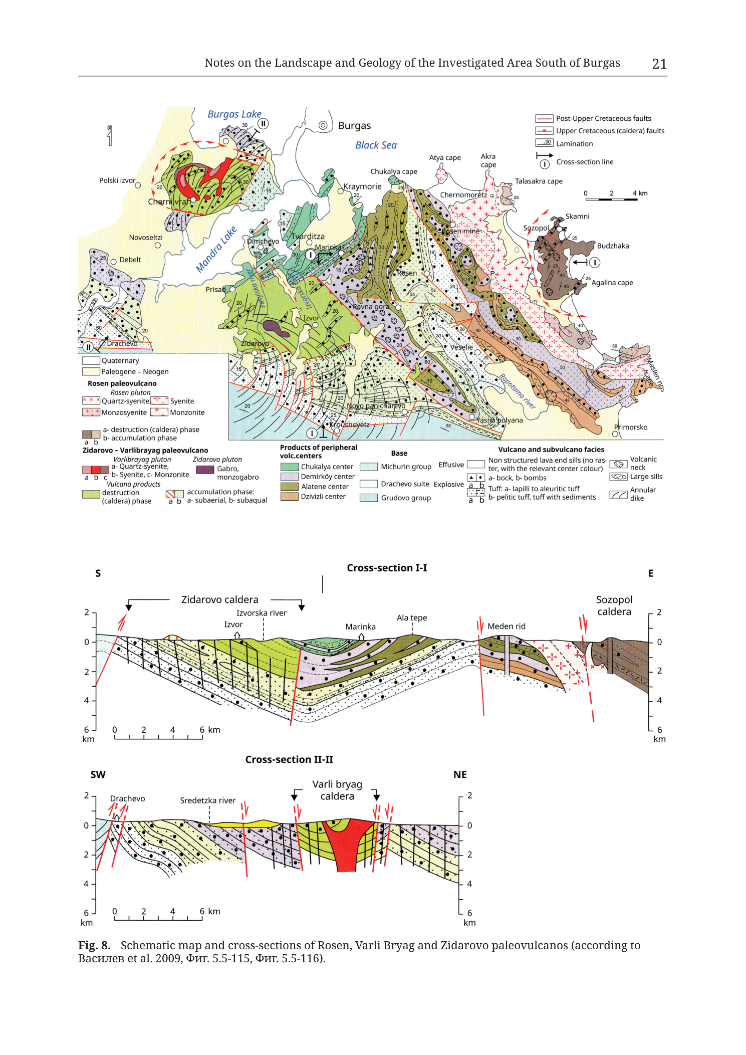
“Fig. 8. Schematic map and cross-sections of Rosen, Varli Bryag and Zidarovo paleovulcanos (according to Василев et al. 2009, Фиг. 5.5-115, Фиг. 5.5-116).”
Translation (source citation only): Василев = Vasilev (Cyrillic author name); Фиг. = Fig. (Bulgarian abbreviation for figure).
Description
TYPE & PURPOSE
Multi-panel schematic plate combining (1) a regional paleovolcanic–geological map of the area south of Burgas (SE Bulgaria, Black Sea coast) and (2) two interpretative geological cross-sections (I-I and II-II). The plate synthesises the Rosen, Varli Bryag, and Zidarovo paleovolcanoes, their caldera-bounding Upper Cretaceous faults, post-Upper Cretaceous faults, peripheral volcanic centres, plutonic cores (Rosen, Varlibrayag, Zidarovo plutons), volcanic facies (effusive, explosive, tuffs), and pre-volcanic basement groups. Purpose: locate the three paleovolcanic systems relative to one another, the Black Sea coast, Burgas/Mandra lakes, and key settlements/mines (notably Rosen mine, Meden rid), and show subsurface geometry of calderas and plutons along two section lines. Source attribution in the caption is to Vasilev et al. 2009 (figures 5.5-115 and 5.5-116).
FRAME, EXTENT, ORIENTATION
- Full-page portrait layout: map occupies the upper ~45–50% of the figure area; Cross-section I-I the middle band; Cross-section II-II the lower band; caption beneath.
- Map orientation: north up (explicit N arrow, upper left of map).
- Geographic extent: regional strip of SE Bulgaria from inland Debelt / Drachevo / Zidarovo on the west to the Black Sea coast (Kraymorie–Chernomoretz–Sozopol–Primorsko) on the east, and from Burgas Lake / Burgas city on the north to Primorsko / Novo panicharevo on the south. Covers the Medni Rid / Rosen hills and the broader Burgas volcano-plutonic region.
- No printed numeric coordinate grid, UTM, or lat/long ticks on the map. Location control is by place names, lakes, and coastline only.
SCALE
- Map scale bar: 0–2–4 km (upper right of map). No ratio scale (1:x) printed.
- Represented map ground distance: the 4 km bar is a small fraction of the full E–W frame; full mapped corridor is on the order of several tens of kilometres coast-to-inland and N–S (visual estimate against the 4 km bar — Burgas Lake to Primorsko spans many bar-lengths).
- Cross-sections I-I and II-II each carry a 0–2–4–6 km horizontal scale bar. Vertical axes run from about +2 km to −6 km (8 km total vertical span printed). No explicit vertical-exaggeration statement; the horizontal 6 km bar compared with the densely folded/faulted geology suggests moderate schematic vertical exaggeration typical of interpretative crustal sections, but VE is not quantified on the plate.
COORDINATES / GRID
- None printed on map or sections. Catalogue-style UTM centroid consistency check does not apply.
RELIEF & PHYSIOGRAPHY (map)
- Map is a planar geological colour map, not a topographic or LiDAR product: no contours, no hillshade, no elevation tint.
- Physiography implied by coastline shape (Burgas embayment, Sozopol peninsula/cape chain, Maslen nos), inland lakes (Burgas Lake, Mandra Lake), and the NW–SE to W–E elongated geological belts of the Rosen paleovolcano and flanking centres.
- Cross-section topography (I-I, II-II): gently undulating free surface drawn between roughly 0 and +1–2 km on the vertical scale, with local highs under Marinka / Ala tepe / Meden rid (I-I) and over the Varli bryag caldera centre (II-II), and a mild depression under the Izvorska river marker (I-I) and Sredetska river marker (II-II).
HYDROGRAPHY & COAST
- Black Sea occupies the NE to E edge of the map (uncoloured).
- Named lakes: Burgas Lake (N), Mandra Lake (W-central, elongated, connected conceptually to the coastal lake system west of Burgas).
- Named rivers on sections: Izvorska river (I-I), Sredetska river (II-II). On the map face: Ropotamo river is drawn and labelled as a blue drainage in the SE sector flowing toward the Black Sea between Sozopol/Budzhaka and Primorsko/Maslen nos.
- Coastal cape chain (N→SE): Chukalya, Atya, Akra, Talasakra, then Sozopol area with Skamni rocks, Agalina cape, Maslen nos.
ANTHROPOGENIC / CULTURAL FEATURES
- Settlements marked with open or filled circles across the map (list fully transcribed above). Key archaeological/mining-relevant names present: Rosen, Rosen mine, Cherni vrah, Budzhaka, Sozopol, Chernomoretz, Atia/Atya cape, Primorsko, Zidarovo, Drachevo, Marinka, Veselie, Yasna polyana.
- “Rosen mine” is explicitly labelled east of the Rosen pluton / toward Chernomoretz–Sozopol, inside the eastern Rosen paleovolcanic products.
- No individual shaft, adit, spoil-heap, fortress-wall, or kiln symbols beyond the place-name “Rosen mine”.
- Burgas marked with a circled-dot city symbol north of the coast.
GEOLOGICAL CONTENT — MAP
Cover
- Quaternary — white. Coastal and lowland patches, including areas around lakes and the lower river courses; discontinuous veneer.
- Paleogene – Neogen — pale yellow. Broader lowland/cover polygons west and north of the paleovolcanic cores (around Debelt, Novoseltsi, and lake fringes) and other fringe areas.
Rosen paleovolcano / Rosen pluton
- Central and E-central map: large intrusive body rendered in pink to red with dense “+” overprint symbols, labelled regionally “Rosen”. Legend subdivides:
- Quartz-syenite, Syenite, Monzosyenite, Monzonite — warm pink/red plutonic suite with cross “+” ornament.
- Flanking brown fields coded a/b as destruction (caldera) phase vs accumulation phase of the Rosen paleovolcano — notably a substantial brown body toward the SE coastal sector (Sozopol caldera area on section I-I).
- Green volcanic packages of the Rosen system and related caldera products occupy large areas west and south of the pink pluton (toward Ravna gora, Veselie, Izvor) and north toward Cherni vrah.
Zidarovo – Varlibrayag paleovolcano
- Varlibrayag pluton (a/b/c = Quartz-syenite / Syenite / Monzonite) — red-brown suite in the western sector near Cherni vrah / north of Mandra Lake, outlined in part by red caldera-fault arcs (dashed red ellipse in NW).
- Zidarovo pluton — purple Gabro / monzogabro body near Zidarovo (SW-central).
- Vulcano products for this pair: solid green = destruction (caldera) phase; hatched green a/b = accumulation phase (subaerial vs subaqual).
Peripheral volcanic centres (colour polygons)
- Chukalya center — medium green (coastal sector near Chukalya cape / Kraymorie).
- Demirköy center — pale lavender (patches in SW and other fringe positions).
- Alatene center — olive/khaki (belts near the central-southern map).
- Dzivizli center — brown (limited polygons in the southern/central volcanic mosaic).
Base (pre-/infra-volcanic)
- Michurin group — pale sage green-grey belts interleaved with volcanic products.
- Drachevo suite — very pale / white units, especially west near Drachevo.
- Grudovo group — light blue basement-style polygons, often at deeper structural position and outer map fringes.
Facies symbols overprinted on colour fields
- Bedding / lamination ticks with numeric dip values (10–50° range as printed) across stratified volcanic and base units — preferred orientations vary; many ticks in the central Rosen field dip away from or around the pluton/caldera structures.
- Explosive symbols: filled triangles = blocks/bombs (legend: a – bock [block], b – bombs).
- Tuff ornament subdivided a/b (lapilli–aleuritic vs pelitic/sediment-bearing).
- Volcanic neck, large-sill, and annular-dike ornaments locally (annular-dike symbol style matches the curved double-arc glyph in the legend).
- Effusive lavas/sills take the host centre’s colour without extra raster.
Structure
- Upper Cretaceous (caldera) faults — red double-line traces, commonly arcuate, outlining Rosen, Zidarovo, and Varli Bryag caldera margins (including the prominent red dashed arc looping north of Cherni vrah / Varlibrayag and red arcs on the E side of Rosen toward Sozopol).
- Post-Upper Cretaceous faults — black double-line traces, generally more linear, transecting older caldera and volcanic fabrics (several cut the central and SE Rosen field and areas near Ropotamo / Primorsko).
- Cross-section lines I-I and II-II as described in Transcription.
ORE BODIES / DEPOSITS
- “Rosen mine” is the principal explicit mine label on the map, sitting in the eastern Rosen paleovolcanic field inland of Chernomoretz / Sozopol, near the pluton–volcanic contact corridor.
- “Meden rid” appears as a surface label on Cross-section I-I above the pink intrusive body and adjacent volcanic wedges — this is the Meden Rid / Medni Rid locus of the Rosen ore field chain (the section places it between Ala tepe and the Sozopol caldera margin, cut by a steep red fault).
- Individual named satellite deposits (Korucheshme, Sarneshko Kladenche, Propadnala Voda, etc.) are not labelled on this schematic regional plate.
- No crossed-picks ore-deposit symbol key is used; mineralisation is implied by “Rosen mine” and by the regional association of the Rosen pluton contact zone rather than by a deposit inventory.
CROSS-SECTION I-I — DETAILED GEOMETRY
- Trace on map: approximately south → east (labelled S at left end of section, E at right), from the Zidarovo area inland, through Izvor / Marinka / Ala tepe / Meden rid, into the Sozopol caldera toward the coast.
- Horizontal length billed to at least 6 km on the scale bar; actual drawn section is longer than the 6 km bar (bar sits under the left portion only).
- Vertical datum: kilometres relative to a 0 level near mean surface; section rocks shown from near-surface down to −6 km.
- Zidarovo caldera (left): surface bracket; underlying green stratified volcanic fill resting on cool blue/grey basement-like layers; left margin cut by steep red faults with normal-sense arrow pairs (caldera-bounding or reactivated faults).
- Izvor / Izvorska river: topographic low; green accumulation-phase package at surface.
- Marinka: surface marker on a green high; stratified greens and pale layers beneath with apparent anticlinal/synformal undulations.
- Ala tepe: dashed vertical reference; layered volcanic sequence continues.
- Meden rid: sits above a steep red fault that drops/juxtaposes brown and green wedges against the pink “+” Rosen pluton body; mineralisation-relevant geometry — Meden rid lies at the faulted volcanic–pluton contact.
- Rosen pluton in section: pink body with red “+” symbols occupying much of the eastern half of the subsurface from near 0 down past −2/−4 km, expanding under Sozopol caldera.
- Sozopol caldera (right): brown destruction-phase caldera fill at and below surface on the east end; steep red faults (one solid with kinematic arrows, one dashed) bound/cross the caldera margin.
- Bedding in the western portion generally shows gentle to moderate apparent dips; near Meden rid dips steepen against the pluton and faults.
- No boreholes are drawn.
CROSS-SECTION II-II — DETAILED GEOMETRY
- Trace on map: approximately SW → NE (labelled SW left, NE right), from near Drachevo across the western Varli Bryag system toward the Burgas Lake sector.
- Horizontal scale bar 0–6 km under left part of section; vertical axes identical to I-I (+2 to −6 km).
- Drachevo (SW end): pale layered cover and base packages cut by a cluster of steep red faults with normal-sense half-arrows — post- or syn-tectonic brittle structure on the SW flank.
- Sredetska river: surface drainage marker above faulted layered sequence.
- Varli bryag caldera (central): surface bracket over a large solid red plutonic body (Varlibrayag pluton) that forms a crude stock/dome from near surface (locally slightly above 0) down below −2 km, flanked and roofed by pale lavender and bedded volcanic/cover units. Multiple steep red faults with kinematic arrows cut the caldera shoulders — schematic caldera-collapse or resurgent-margin faulting.
- Cool blue basement-style unit at depth under the SW–central section (−4 to −6 km).
- NE limb: bedded sequence continues with moderate dips away from the pluton/caldera core toward the Burgas Lake side of the map.
- No boreholes drawn.
COLOUR & SYMBOL SYSTEM
- Warm pink/red + “+” = intermediate–felsic Rosen / Varlibrayag plutonic suites.
- Purple = Zidarovo gabbro/monzogabbro.
- Green family = volcanic products (destruction vs accumulation; also Chukalya / Alatene peripheral centres).
- Lavender = Demirköy centre and some flanking volcanic packages.
- Brown family = caldera destruction-phase piles and Dzivizli centre.
- Yellow/white = Paleogene–Neogene / Quaternary cover.
- Blue = Grudovo group basement and water bodies.
- Red lines = Upper Cretaceous caldera faults; black double lines = younger faults.
- Lamination ticks + dip numbers encode stratification attitude.
SPATIAL RELATIONSHIPS
- Three paleovolcanic systems are mosaicked west-to-east/south:
- Varli Bryag (NW, Cherni vrah area) with Varlibrayag pluton and red caldera outline — shown in section II-II as a red stock with faulted margins.
- Zidarovo (SW-central) with purple gabbro/monzogabbro pluton and green caldera products — section I-I starts in Zidarovo caldera.
- Rosen (central–east) with large pink pluton, Rosen mine on its eastern volcanic flank, Meden rid on section I-I at the pluton–volcanic faulted contact, and Sozopol caldera as the SE coastal caldera filled with brown destruction-phase material overlying/adjacent to the pluton.
- Peripheral centres (Chukalya coastal; Demirköy, Alatene, Dzivizli inland/south) ring or abut the main three systems.
- Ore-relevant corridor of this collection (Medni Rid / Rosen field) sits on the eastern Rosen paleovolcano: Rosen mine and Meden rid are tied to the eastern pluton contact and caldera-faulted volcanic pile — consistent with other figures that place the five deposits along the tuff/pluton contact inland of Chernomorets–Sozopol.
- Lakes and Paleogene–Neogene/Quaternary cover mask older geology toward Burgas and the lowlands; the Black Sea truncates the eastern geology at the cape chain.
- Post-Upper Cretaceous faults cut across caldera fabrics, indicating younger brittle overprint after caldera formation.
RELATIONSHIP TO OTHER FIGURES
- This is Fig. 8 in the Tübingen monograph chapter “Notes on the Landscape and Geology of the Investigated Area South of Burgas” (Krauss et al. 2020). Caption sources the schematics to Vasilev et al. 2009 (Фиг. 5.5-115, 5.5-116).
- Companion figures in the same book arm / chapter sequence include the Medni Rid overview (Tub Fig. 1 / p. 018 material), the 1879 geological map (Fig. 4), tectonic/metallogenic schemes (Figs. 5–6), and later detail maps of Rosen / Varli Bryag / Zidarovo ore fields (e.g. Tub_p024_Fig9, Tub_p026_Fig11, Tub_p027_Fig12 in this collection). Cross-section geometry here is the regional 3-D framework those more detailed ore-field maps sit inside.
- Filename page hint “p023” vs printed header “21” reflects differing PDF pagination vs book printed page numbering; content identity is Fig. 8.
Notes
- No UTM/lat-long grid: catalogue centroid consistency check not applicable.
- Printed page number in the header is 21; filename uses Tub_p023 (PDF-page style). Both retained in front-matter.
- Legend spelling is as printed: “Varlibrayag”, “paleovulcano(s)”, “Vulcano”, “bock” (for block), “subcuadr”→“subaqual”, “Paleogene – Neogen”, “Gabro, monzogabro”, “raster” in the effusive note (“no raster”). Not silently corrected.
- Caption retains Cyrillic “Василев” and “Фиг.” as printed; Latin back-transliteration given once under Transcription.
- Dip numbers on the map are numerous and small; major visible values are listed, but dense clusters may hide additional identical-range numbers — none were invented.
- Cross-section horizontal length exceeds the printed 6 km bar segment (bar is a scale key, not a full-section ruler). Vertical exaggeration not stated.
- “Meden rid” orthography on the section uses lowercase “rid”; equals Meden Rid / Medni Rid of other figures in this collection.
- Schematic nature (after Vasilev et al. 2009): contacts and pluton shapes are interpretative, not survey-precise.
- None further.