Description
Transcription
Page header
- Left:
20 - Centre:
Kalin Dimitrov - Horizontal rule under header.
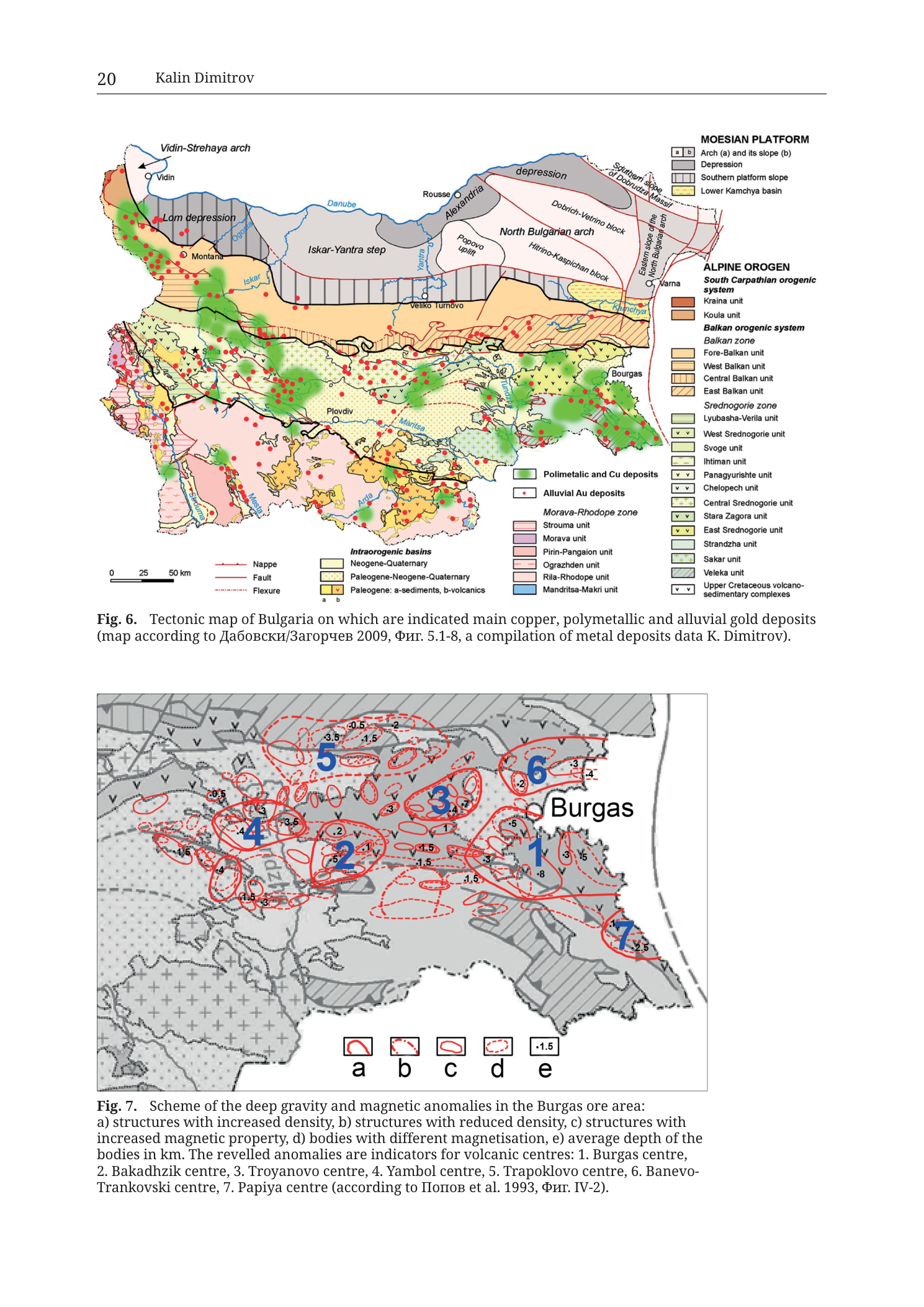
Fig. 6 (upper panel) — Tectonic map of Bulgaria with metal deposits
Caption (below map):
Fig. 6.  Tectonic map of Bulgaria on which are indicated main copper, polymetallic and alluvial gold deposits
(map according to Дабовски/Загорчев 2009, Фиг. 5.1-8, a compilation of metal deposits data K. Dimitrov).
Translation:
- Дабовски = Dabovski
- Загорчев = Zagorchev
- Фиг. = Fig.
Scale bar (lower-left of map):
02550 km
Deposit / structure symbol key (lower-centre of map area):
- Green filled rectangle —
Polimetalic and Cu deposits(polymetallic and Cu deposits; spelling as printed “Polimetalic”) - Red filled circle —
Alluvial Au deposits - Red heavy line —
Nappe - Red thin line —
Fault - Red dashed line —
Flexure
Intraorogenic basins key (beside structure symbols):
- Pale cream/beige box —
Neogene-Quaternary - Pale yellow box —
Paleogene-Neogene-Quaternary - Yellow box with
a|bsplit and smallv vmark in b —Paleogene: a-sediments, b-volcanics
MOESIAN PLATFORM (legend block, upper-right)
Header: MOESIAN PLATFORM
a | bgrey boxes —Arch (a) and its slope (b)- Medium grey box —
Depression - Horizontal-ruled grey box —
Southern platform slope - Pale yellow box —
Lower Kamchya basin
ALPINE OROGEN (legend block, right side)
Header: ALPINE OROGEN
South Carpathian orogenic system
- Brown box —
Kraina unit - Light brown/tan box —
Koula unit
Balkan orogenic system
- Subheader:
Balkan zone- Pale tan —
Fore-Balkan unit - Tan —
West Balkan unit - Medium tan —
Central Balkan unit - Ruled tan —
East Balkan unit
- Pale tan —
Srednogorie zone
- Light green —
Lyubasha-Verila unit - Green with
v v—West Srednogorie unit - Pale green —
Svoge unit - Light green —
Ihtiman unit - Green with
v v—Panagyurishte unit - Pale green with
v v—Chelopech unit - Light green —
Central Srednogorie unit - Green with
v v—Stara Zagora unit - Green with
v v—East Srednogorie unit - Pale mint green —
Strandzha unit - Fine-dotted pale green —
Sakar unit - Diagonal-ruled pale —
Veleka unit - Green with
v v—Upper Cretaceous volcano-sedimentary complexes
Morava-Rhodope zone
- Pink-lilac —
Strouma unit(Struma) - Medium purple-pink —
Morava unit - Pink —
Pirin-Pangaion unit - Light pink —
Ograzhden unit - Pale pink —
Rila-Rhodope unit - Light blue —
Mandritsa-Makri unit
Map-face place and tectonic labels (selected, as printed)
Moesian Platform / north:
Vidin-Strehaya arch(NW)VidinLom depressionMontanaDanube(river)Ogosta(river)Iskar(river)Iskar-Yantra stepYantra(river)RousseAlexandria(NE, beyond Danube / Romanian side label)Popovo upliftNorth Bulgarian archDobrich-Vetrino blockHitrino-Kaspichan blockSouthern slope of Dobruja massif/ related NE slope labelsEastern slope of North Bulgarian archKamchiya(river)Varnadepression(label on northernmost platform depression strip)
Alpine orogen / central and south:
Sofia(with blue star)Veliko TurnovoPlovdivBurgas(east coast — key city for the study area)Maritsa(river)Tundzha(river, implied in east-central drainage)Arda(river)Mesta(river, SW)Struma(river, WSW)
Green clusters of Cu/polymetallic deposits are dense in NW Bulgaria, the Panagyurishte–central Srednogorie belt, east toward Burgas, and other orogenic strips on the green Srednogorie/related units. Red alluvial Au dots are widespread, with strong concentrations in NW Bulgaria and scattered elsewhere including south of the main orogen.
Fig. 7 (lower panel) — Gravity and magnetic anomaly scheme, Burgas ore area
Caption (below map):
Fig. 7.  Scheme of the deep gravity and magnetic anomalies in the Burgas ore area:
a) structures with increased density, b) structures with reduced density, c) structures with
increased magnetic property, d) bodies with different magnetisation, e) average depth of the
bodies in km. The revellled anomalies are indicators for volcanic centres: 1. Burgas centre,
2. Bakadhzik centre, 3. Troyanovo centre, 4. Yambol centre, 5. Trapoklovo centre, 6. Banevo-
Trankovski centre, 7. Papiya centre (according to Попов et al. 1993, Фиг. IV-2).
Notes on caption spelling as printed:
revellled= revealed (typo in source caption)- Попов = Popov
- Фиг. = Fig.
Legend (bottom-centre of Fig. 7 map, symbols a–e):
| Key | Symbol (as drawn) | Meaning (from caption) |
|---|---|---|
| a | Heavy red closed outline (thick irregular closed shape) | structures with increased density |
| b | Red field with internal stipple/dot pattern inside a boundary | structures with reduced density |
| c | Red single closed contour line | structures with increased magnetic property |
| d | Red dashed closed contour | bodies with different magnetisation |
| e | Numeric label e.g. -1.5 |
average depth of the bodies in km |
Numbered volcanic centres (large blue numerals on the map):
1— Burgas centre (largest, immediately west/SW of the printed nameBurgas)2— Bakadhzik centre (west-central cluster)3— Troyanovo centre (north-central, north of 1–2)4— Yambol centre (far west)5— Trapoklovo centre (NW, north of 4–2)6— Banevo-Trankovski centre (NE of Burgas / north-east cluster)7— Papiya centre (SE coastal/strandza-ward cluster south of Burgas)
Depth labels (examples of printed values next to anomaly contours; values in km as average depths, often negative convention as printed):
- Near centre 1 (Burgas):
-8,-5,-3,-1.5,1.5,3and related contour values - Near centre 2:
-2,-1,-1.5,1.5 - Near centre 3:
-4,-3,-2,-1(and similar) - Near centre 4:
-5,-4,-3.5,-1.5 - Near centre 5:
-3.5,-1.5,-0.5,2 - Near centre 6:
-4,-3,-2 - Near centre 7:
-2.5 - Other scattered values:
-0.5,0.5,2,4, etc., along subsidiary contours
(Exact full inventory of every tiny depth numeral is at the legibility limit; major labelled depths adjacent to the seven centres are as above.)
Base map content under the anomaly overlays:
- Greyscale topographic/tectonic line underlay of the Burgas region and inland west toward Yambol.
- Coastline of the Black Sea on the east with Burgas Bay indentation; name
Burgasin large bold type east-centre. - Fine black drainage and contour/structure linework; product of reduced-density stippled zones and greenish-grey geological underlay patches (v-pattern Upper Cretaceous volcano-sedimentary style matching Fig. 6 legend language).
- No separate geographic coordinate graticule with numeric ticks is clearly printed on Fig. 7.
- No discrete scale bar on Fig. 7 (extent is regional around Burgas; relation to Fig. 6 east-coast Burgas southern node).
Description
TYPE & PURPOSE
Book page with two complementary national-to-local metallotectonic figures:
- Fig. 6 — tectonic map of all Bulgaria showing Alpine orogen and Moesian Platform units, with overplotted main copper/polymetallic deposits (green) and alluvial gold deposits (red). Base tectonic map after Dabovski & Zagorchev 2009, Fig. 5.1-8; deposit compilation by K. Dimitrov.
- Fig. 7 — scheme of deep gravity and magnetic anomalies in the Burgas ore area, interpreted as indicators of seven named volcanic centres (including the Burgas centre adjacent to the Medni Rid / Rosen coastal sector). After Popov et al. 1993, Fig. IV-2.
Together they link national deposit pattern (Fig. 6) to the geophysical signature of volcanic centres that organised ore formation in the Burgas district (Fig. 7).
Fig. 6 — Tectonic map of Bulgaria with Cu/polymetallic and alluvial Au deposits
TYPE & PURPOSE
National tectonic map + metallogenic point overlay. Purpose: show where copper, polymetallic, and alluvial gold deposits sit relative to major tectonic units of Bulgaria — especially the Srednogorie zone (including East Srednogorie at the Burgas coast) versus Moesian Platform, Balkan zone, and Morava-Rhodope zone.
FRAME, EXTENT, ORIENTATION
- Outline map of Bulgaria (with immediately adjacent fringe of Romania/Serbia/Greece/Turkey borders as thin edge).
- North up.
- Black Sea forms the eastern margin; Danube the northern; southern border toward Greece/Turkey; western border toward Serbia/North Macedonia.
- Legend columns occupy the right side and lower fringe; map proper is left/centre.
SCALE
- Graphical scale: 0 – 25 – 50 km.
- Full country span is several hundred kilometres E–W and N–S.
COORDINATES / GRID
- No numeric lat/long or UTM graticule printed.
- Catalogue centroid consistency check does not apply.
RELIEF & PHYSIOGRAPHY
- Not hypsometric; tectonic unit colours replace topography.
- Major rivers drawn in blue (Danube, Iskar, Yantra, Kamchiya, Maritsa, Tundzha, Arda, Mesta, Struma, Ogosta, etc.) as orientation features.
GEOLOGICAL / TECTONIC CONTENT (legend order / groups)
Moesian Platform (north):
- Arches and slopes (Vidin-Strehaya arch, North Bulgarian arch, Popovo uplift, Dobrich-Vetrino and Hitrino-Kaspichan blocks, eastern/southern platform slopes).
- Depressions (Lom depression, northern depression strip).
- Lower Kamchya basin — pale yellow coastal basin south of Varna, along the Kamchiya, immediately north of the Burgas East-Srednogorie area.
Alpine Orogen:
- South Carpathian system (NW) — Kraina, Koula units.
- Balkan orogenic system — Fore-Balkan, West/Central/East Balkan units as a W–E mountain belt south of the Moesian Platform.
- Srednogorie zone — homes the principal Late Cretaceous volcano-plutonic and ore belts:
- West Srednogorie, Panagyurishte, Chelopech, Central Srednogorie, Stara Zagora, East Srednogorie, plus Lyubasha-Verila, Svoge, Ihtiman, Strandzha, Sakar, Veleka units.
- Explicit legend entry for Upper Cretaceous volcano-sedimentary complexes (v-pattern green).
- Morava-Rhodope zone (south) — Struma, Morava, Pirin-Pangaion, Ograzhden, Rila-Rhodope, Mandritsa-Makri units; blue Mandritsa-Makri at the SE Rhodope fringe.
Intraorogenic basins — Neogene–Quaternary and Paleogene–Neogene–Quaternary fills; Paleogene sediments vs volcanics (a/b).
Structure linework: nappes (heavy red), faults (thin red), flexures (dashed red).
ORE DEPOSITS (overlay)
- Green rectangles — polymetallic and copper deposits. Major clusters:
- NW Bulgaria (Montana–Vidin country and West Balkan / western Srednogorie fringe).
- Central Srednogorie / Panagyurishte–Chelopech belt (famous Cu-Au porphyry-epithermal district inland of Sofia–Plovdiv latitudes).
- Eastern cluster around and inland of Burgas on East Srednogorie / Strandzha-related greens — the district that contains Medni Rid / Rosen / Varli Bryag / Zidarovo ore fields treated elsewhere in the collection.
- Smaller green groups in Rhodope / southern units.
- Red dots — alluvial gold deposits, widespread; dense in NW Bulgaria, present along various drainages, and scattered south of the main orogen.
No individual deposit names (Rosen, Chelopech, etc.) are printed as text labels on the point symbols — only the two-class symbol key.
SPATIAL RELATIONSHIPS
- Cu/polymetallic deposits strongly follow Srednogorie and related Alpine orogen units, not the open Moesian Platform interior.
- The Burgas coastal node sits on East Srednogorie / Upper Cretaceous volcano-sedimentary ground at the Black Sea — the national-map location of the monograph’s working district.
- Alluvial Au is more dispersed hydrologically than the hard-rock Cu/polymetallic belts.
- Lower Kamchya basin and Moesian arches form the northern non-Srednogorie frame above the Burgas district.
RELATIONSHIP TO OTHER FIGURES
- Companion national-scale follow-on to Fig. 5 tectonic scheme (prior page).
- Deposit pattern at Burgas is geophysically developed in Fig. 7 on the same page.
- Base tectonics: Dabovski & Zagorchev 2009; deposits: K. Dimitrov compilation.
Fig. 7 — Deep gravity and magnetic anomalies, Burgas ore area
TYPE & PURPOSE
Geophysical interpretation map (gravity + magnetics) of the Burgas ore area. Coloured/contour red overlays on a muted base show density and magnetic structures; large blue numbers 1–7 mark interpreted volcanic centres. Purpose: argue that the revealed anomalies indicate discrete volcanic centres that organised the Late Cretaceous magmatic–metallogenic architecture of the Burgas district (including the coastal sector relevant to Medni Rid).
FRAME, EXTENT, ORIENTATION
- Rectangular panel focused on SE Bulgaria around Burgas, extending west inland past the Bakadhzik–Yambol sector and south toward Strandzha foothills (Papiya centre).
- North up.
- Black Sea and Burgas Bay on the east; name Burgas large near the coast.
- No printed degree grid.
SCALE
- No graphical scale bar on Fig. 7.
- Relative scale is regional (tens of km across); readable by relation to Burgas Bay geometry and to Fig. 6’s Burgas node.
GEOPHYSICAL CONTENT
Symbol classes (a–e):
- (a) Increased density — thick solid red closed outlines (high-density bodies/structures).
- (b) Reduced density — red stippled fills (low-density structures).
- (c) Increased magnetic property — solid red closed contours.
- (d) Different magnetisation — dashed red closed contours.
- (e) Average depth (km) — numeric labels on contours/bodies (printed values such as −8, −5, −3.5, −2.5, −1.5, −0.5, 0.5, 1.5, 2, 3, 4, …). Negative signs are as printed on the figure (source convention for depth notation on this plate).
Seven volcanic centres (blue numbers + caption names):
| No. | Name | Approximate map position relative to Burgas |
|---|---|---|
| 1 | Burgas centre | Immediately west/SW of Burgas; largest multi-contour anomaly complex; deepest labels include −8 km class values |
| 2 | Bakadhzik centre | West of 1, inland |
| 3 | Troyanovo centre | North of 1–2 |
| 4 | Yambol centre | Far west |
| 5 | Trapoklovo centre | NW sector |
| 6 | Banevo-Trankovski centre | NE of Burgas |
| 7 | Papiya centre | SE of Burgas along the southern coastal/Strandzha-ward side |
Anomaly contours are nested and overlapping; several centres share elongated E–W to WNW–ESE coalesced anomaly belts, consistent with an aligned volcano-plutonic chain rather than a single isolated stock.
BASE GEOLOGY / TOPOGRAPHY (underlay)
- Muted grey topographic drainage and hill linework.
- Patchy geological ornament including v-pattern areas consistent with Upper Cretaceous volcano-sedimentary complexes of the East Srednogorie (links visually to Fig. 6 legend).
- Coastline detailed enough to show Burgas Bay and southward coastal irregularities.
SPATIAL RELATIONSHIPS
- Centre 1 (Burgas) dominates the coastal ore-area for the monograph cares about: it is the geophysical locus next to Burgas Bay, i.e. the magmatic centre framework for ore fields of the Medni Rid–Rosen–Atiya–Chernomorets coastal belt treated in catalogue and geological plates.
- Centres 2–5 form an inland westward chain (Bakadhzik–Troyanovo–Yambol–Trapoklovo) — the inland Burgas ore-region volcano-plutonic nodes.
- Centre 6 (Banevo-Trankovski) sits NE, on the northern flank of the Bay sector.
- Centre 7 (Papiya) sits SE toward Strandzha coastal hills.
- Depth labels show a range of average body depths from shallow (<1–2 km class) to deep (several km, with Burgas centre showing notably deep values including an −8 km label) — evidence the compilation treats both shallow and mid-crustal density/magnetic sources.
- Reduced-density (b) vs increased-density (a) patterns differentiate plutonic/volcanic high-density cores from lighter volcano-sedimentary or basin fills.
RELATIONSHIP TO OTHER FIGURES
- Zooms the Burgas deposit cluster of Fig. 6 into a geophysical volcanic-centre model.
- Contextualises later Rosen / Varli Bryag / Zidarovo structural and cross-section figures as local expressions within the Burgas volcanic-centre system (especially centre 1 and neighbours).
- Source: Popov et al. 1993, Fig. IV-2.
Notes
- No UTM catalogue centroid consistency check applies to either figure.
- Fig. 6 spelling “Polimetalic” is as printed (not corrected to “Polymetallic” in transcription).
- Fig. 7 caption spelling “revellled” is as printed.
- Cyrillic author names in captions (Дабовски, Загорчев, Попов, Фиг.) transcribed as printed with transliterations in the description.
- Not every minute depth numeral on Fig. 7 is individually listed when crowding/overlap prevents secure digit reading; major values at the seven centres are given.
- Fig. 7 has no scale bar; ground distances are qualitative relative to Burgas Bay.
- Filename
Tub_p022vs printed page 20 is PDF offset vs folio. - None further.