Description
Transcription
Page header
- Centre:
Notes on the Landscape and Geology of the Investigated Area South of Burgas - Right:
19 - Horizontal rule under header.
Caption (below map)
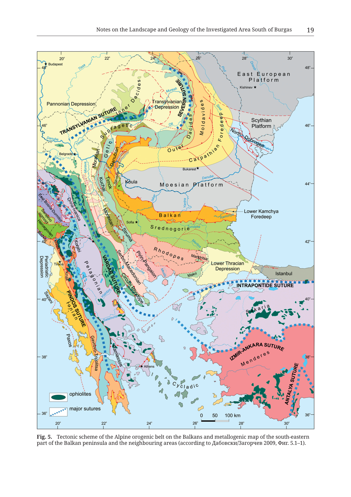
Fig. 5.  Tectonic scheme of the Alpine orogenic belt on the Balkans and metallogenic map of the south-eastern
part of the Balkan peninsula and the neighbouring areas (according to Дабовски/Загорчев 2009, Фиг. 5.1–1).
Translation of citation names/terms:
- Дабовски = Dabovski
- Загорчев = Zagorchev (also Zagorčev / Zagorchev)
- Фиг. = Fig.
Coordinate graticule (frame edge labels)
Longitude (top and bottom edges), west → east:
20°22°24°26°28°30°
Latitude (left and right edges), north → south:
48°46°44°42°40°38°36°
Scale bar (bottom-centre of map)
- Tick/segment bar labelled:
050100 km - No ratio scale (e.g. 1:x) printed beyond the graphical bar.
Legend (lower-left corner of map frame)
- Filled dark-green elongated oval symbol —
ophiolites - Blue dashed-line swatch in a box —
major sutures
No other legend entries are printed. Tectonic-unit colours are identified by large labels printed on the map face itself, not by a unit-by-unit colour key.
Cities / capitals (black stars with names)
Budapest(NW, with star)Belgrade(star; NW of central Balkans)Bukarest(Bucharest; star, on Moesian Platform side)Kishinev(Chișinău; star, East European Platform)Sofia(star; central Bulgaria)Tirana(star; Albania)Athens(star; southern Greece)Istanbul(labelled on the Bosporus / North Anatolian sector; red linework nearby)
Seas / large waterbodies (blue fill; names as printed where labelled)
- Unlabelled open water fills corresponding to the Adriatic / Ionian west, Aegean centre-south, and Black Sea / north-east blue field (Black Sea occupies the NE corner between East European Platform, Scythian Platform, North Dobrogea and the Istanbul coast).
- Aegean archipelago area with label
Cycladicacross the southern Aegean field.
Major tectonic / geologic province labels (as printed on the map face)
Northern and north-eastern platforms / depressions:
East European Platform(NE, grey)Scythian Platform(east of Carpathian Foredeep / north of Black Sea western shelf sector, grey)Pannonian Depression(NW, pale yellow)Transylvanian Depression(within Carpathian curve, pale)Moesian Platform(north Bulgarian / south Romanian plain sector, pale grey-white, large label)Carpathian Foredeep(curved yellow belt outside Outer Carpathians / Moldavides)Lower Kamchya Foredeep(east Bulgarian Black Sea coast sector, small cyan/green wedge labelled)Lower Thracian Depression(SE Bulgaria / northern Aegean approach, pale)Periadratic Depression(west edge, vertical label)
Carpathian–Dacides system (north-central arc):
TRANSYLVANIAN SUTURE(blue dashed curved belt across northern map, labelled along strike)Inner Dacides(inside Carpathian arc)Outer DacidesMedian Dacides[?] / related Dacides labels along the curved orogenSEVERIN SUTURE(blue dashed arc east of Inner/Median Dacides toward Moldavides — large curved blue dashed belt labelledSEVERIN SUTURE)SuprageticGeticDanubianKraishteregion labels in western Bulgaria / eastern Serbia fringeMoldavides(outer eastern Carpathian flysch belt)North Dobrogea(with red fault/lineament traces, between Scythian Platform and Moesian / Black Sea)
Central Balkan / Bulgaria:
Balkan(orange belt across N Bulgaria)Srednogorie(green belt south of Balkan — key host belt for the Burgas / Medni Rid metallogeny in regional terms)Rhodopes(pink belt south of Srednogorie)Serbo-MacedonianMoravaKula/Koulaarea (Koula labelled north of Sofia sector)- River labels crossing the platforms/orogen:
Danube,Tisza/Tissa,Sava,Timish,Muresh/Mureş,Olt,Siret,Prut,Dnestr,Iskar,Yantra,Kamchya,Tundzha,Maritsa,Struma,Mesta,Vardar/Axiossystem labels as placed
Western Balkans / Dinarides–Hellenides:
East Bosna-DurmitorSarajevoDrina-IvanjicaJadarKorabiVelesregion labelsPelagonianPINDOS SUTURE(blue dashed, western Greece — labelled vertically/along strike withIonianandGavrovo/Tripolitzabelt colours)VARDAR SUTURE(major blue dashed NW–SE belt through Macedonia/Greece — large label)Circum RhodopePirin-Pangaeon/Pirin-PangaionPindosbelt colours (oranges/yellows) along western GreeceIonianbeltGavrovo-Tripolitzabelt labelsParnassosPaxos(westernmost yellow nappe/unit label)SazaniKrasta-CukaliAlpsfringe labels at far NW edge where relevantHercegovinian/ related Dinaric unit labels
Anatolian / Aegean south-east:
INTRAPONTIDE SUTURE(blue dashed, southern Black Sea / N Anatolia coast belt — large label)IZMIR-ANKARA SUTURE(blue dashed through western Anatolia — large label)ANTALYA SUTURE(blue dashed, SW Turkey coast — large label, oriented along strike)Sakaria(Sakarya)MenderesCycladic(Aegean)- Additional green ophiolite polygons scattered in western Turkey, Aegean, and Hellenide belts
Structural linework (not fully enumerated domain-by-domain; symbol classes)
- Blue dashed thick lines = major sutures (per legend), including Transylvanian, Severin, Vardar, Pindos, Intrapontide, Izmir-Ankara, Antalya sutures as labelled.
- Red solid lines = faults / tectonic lineaments (especially dense in North Dobrogea and some platform margins; also local traces elsewhere).
- Black thin lines = internal tectonic unit boundaries and coast/river outlines.
- Dark green filled pods/lenses = ophiolites (per legend), concentrated along suture zones and in Hellenide/Anatolide belts (Vardar zone, Izmir-Ankara zone, Antalya, Albanian–Greek ophiolite belts, etc.).
Metallogenic aspect
- The caption calls the figure both a tectonic scheme and a metallogenic map of the SE Balkan peninsula and neighbouring areas, after Dabovski & Zagorchev 2009, Fig. 5.1–1.
- No separate ore-deposit point symbols, mine-pick icons, or deposit-name callouts (e.g. Rosen, Medni Rid, Burgas) are printed on this figure. Metallogenic content is expressed at the belt / tectonic-unit colour level of the source compilation rather than as a deposit inventory on this page render.
Description
TYPE & PURPOSE
Regional tectonic overview map of the Alpine orogenic belt on the Balkans and adjacent platforms, extending into western Anatolia and the Aegean. It is simultaneously presented (per caption) as a metallogenic map of the south-eastern Balkan Peninsula and neighbouring areas, redrawn/after Dabovski & Zagorchev 2009, Fig. 5.1–1. Purpose in the monograph: embed the Burgas / Medni Rid / Srednogorie study area in its plate-tectonic and metallogenic belt context (Srednogorie tectonic–magmatic zone of the Late Cretaceous Apuseni–Banat–Timok–Srednogorie belt) before local geology and archaeology are treated.
FRAME, EXTENT, ORIENTATION
- Single rectangular full-page map.
- North up; geographic coordinates on all four edges.
- Approximate extent:
- W: ~20°E (Adriatic / Albania–Greece longitude; Budapest at NW corner).
- E: ~30°E+ (western Black Sea, western Anatolia, Antalya suture).
- N: ~48°N (Carpathian–Pannonian–East European Platform junction).
- S: ~36°N (southern Greece, Crete latitude belt, Antalya).
- Covers: entire Balkan Peninsula, Carpatho-Pannonian region, Moesian and East European / Scythian platforms, western Black Sea, northwestern quarter of Turkey, Aegean, and western Anatolian sutures.
SCALE
- Graphical scale bar only: 0 – 50 – 100 km near bottom centre.
- No printed ratio scale.
- Full frame spans on the order of ~1000+ km E–W and N–S (multiple 100 km bars).
COORDINATES / GRID
- Geographic graticule in degrees:
- Longitude ticks: 20°, 22°, 24°, 26°, 28°, 30°.
- Latitude ticks: 48°, 46°, 44°, 42°, 40°, 38°, 36°.
- Light grid consistent with those labels.
- No UTM grid; catalogue centroid consistency check does not apply.
RELIEF & PHYSIOGRAPHY
- Not a topographic map. No contours, hillshade, or hypsometric tint.
- Land/sea distinction only: pale-blue sea vs coloured tectonic-unit fills on land.
- Physiography is tectonic: mountain belts appear as elongated coloured strips (Balkan, Srednogorie, Rhodopes, Dinarides–Hellenides, Carpathians); platforms as large pale polygonal fields (Moesian, East European, Scythian, Pannonian Depression).
HYDROGRAPHY & COAST
Major rivers drawn in blue linework with names including (as printed):
- Danube (crossing from Pannonian/Serbian sector across Moesian Platform to the Black Sea delta region)
- Tisza (Tissa), Sava, Timish, Mureş (Muresh), Olt, Siret, Prut, Dnestr
- Iskar, Yantra, Kamchya (with Lower Kamchya Foredeep labelled at the coast)
- Tundzha, Maritsa
- Struma, Mesta
- Vardar system in the Vardar suture corridor
- Other Hellenic drainage traces
Coasts: Adriatic/Ionian west, Aegean with islands (Cycladic label), Sea of Marmara / Bosporus at Istanbul, western Black Sea east of Moesian Platform / North Dobrogea.
ANTHROPOGENIC / CULTURAL FEATURES
- Capital/major city stars only (Budapest, Belgrade, Bukarest, Kishinev, Sofia, Tirana, Athens, Istanbul).
- No roads, railways, mines, or archaeological sites as point symbols.
- Study-area towns (Burgas, Sozopol, Rosen) are not labelled — the map is supra-regional.
GEOLOGICAL / TECTONIC CONTENT
Platforms and undeformed/weakly deformed domains
- East European Platform — grey, NE corner.
- Scythian Platform — grey, north of western Black Sea / east of North Dobrogea.
- Moesian Platform — large pale field N of the Balkan belt, hosting Bukarest label and Danube trunk.
- Pannonian Depression — pale yellow, NW.
- Transylvanian Depression — inside Carpathian loop.
- Carpathian Foredeep — yellow curved belt outside Moldavides.
- Lower Kamchya Foredeep — small eastern Bulgarian coastal unit at the Black Sea — the foredeep geographically nearest the Medni Rid coast north of Burgas.
- Lower Thracian Depression — SE of Rhodopes / toward the Istanbul approach.
- Periadratic Depression — western margin.
Carpathian–Dacide orogen and sutures
- Curved Carpathian stack: Inner Dacides, Median/Outer Dacides, Getic, Supragetic, Danubian, Moldavides — colour ribbons following the Carpathian arc from Serbia around Romania.
- Transylvanian Suture — blue dashed.
- Severin Suture — blue dashed arc between Dacides and Moldavides / toward the eastern Carpathians.
- North Dobrogea — faulted block with prominent red lineaments between Scythian Platform and the Black Sea / Moesian edge.
Balkanide / Srednogorie / Rhodope stack (Bulgaria — research relevance)
- Balkan — orange W–E belt across northern Bulgaria south of the Moesian Platform.
- Srednogorie — green belt immediately south of the Balkan unit. This is the tectonic–magmatic zone that includes the Burgas ore district / Medni Rid / Rosen ore field in refined local maps (not labelled here at deposit scale).
- Rhodopes — pink mass south of Srednogorie, with Pirin-Pangaeon and Circum-Rhodope elements toward the Aegean.
- Serbo-Macedonian and Morava units on the western Bulgarian / eastern Serbian flank.
- Kraishte / related western units in transitional position toward the Vardar system.
Vardar–Hellenide–Dinaride system
- Vardar Suture — major blue dashed NW–SE corridor, ophiolite-bearing (green pods), separating Serbo-Macedonian / Rhodope realm from Pelagonian and more external Hellenide nappes.
- Pelagonian block.
- Pindos Suture and external Hellenide/Ionian/Gavrovo-Tripolitza/Paxos/Sazani nappe colours stacked toward the Adriatic–Ionian edge.
- Dinaric units (East Bosna-Durmitor, Drina-Ivanjica, High Karst-related colours, Korabi, etc.) along the western Balkan peninsula.
Anatolian / Pontide sutures
- Intrapontide Suture along the southern Black Sea / N Anatolian corridor near Istanbul.
- Izmir–Ankara Suture across western Anatolia with ophiolite bodies.
- Antalya Suture along the SW Turkish coast.
- Sakarya and Menderes domains coloured distinctly (including large red/pink Menderes-linked field in SW Anatolia).
- Cycladic domain label in the central-south Aegean.
Ophiolites
- Dark green filled lenses/pods concentrated along the Vardar zone, Albanian–Greek ophiolite belts, Izmir–Ankara zone, Antalya, and other suture-proximal sites — keyed explicitly as
ophiolites.
COLOUR & SYMBOL SYSTEM
- Fill colours encode tectonic units / terranes / depressions (not stratigraphic stage alone). Palette is highly polychrome: greys (platforms), yellows (foredeeps/depressions), oranges (Balkan, parts of Dinarides/Hellenides), greens (Srednogorie, some nappes, ophiolite pods in dark green), pinks/purples/blues (Rhodopes, internal Dinarides–Hellenides, Pelagonian-related), reds (parts of western Anatolia).
- Blue dashed lines = major sutures (legend).
- Red lines = faults/lineaments (especially North Dobrogea).
- Black stars = cities.
- Blue lines = rivers; blue fill = sea.
- No deposit-grade symbol key.
SPATIAL RELATIONSHIPS (analytical core for this collection)
- The monograph’s working area south of Burgas / Medni Rid sits regionally on the eastern Srednogorie tectonic zone where that green belt meets the Black Sea coast, south of the Balkan unit and the Moesian Platform, and north of the Rhodopes / Lower Thracian Depression.
- Lower Kamchya Foredeep is the nearest labelled foredeep unit on the Black Sea coast north of that sector.
- The map explains why copper–gold and related Alpine metallogeny is discussed for this coast: Srednogorie is the Bulgarian segment of the major Late Cretaceous magmatic–metallogenic belt of the region, bounded by platform to the north (Moesian) and Rhodope basement terranes to the south.
- Major sutures (Vardar, Transylvanian, Severin, Pindos, Intrapontide, Izmir–Ankara, Antalya) frame the Alpine collisional geometry of the wider region; Medni Rid is not on a labelled “suture line” on this figure but within the Srednogorie upper-plate / island-arc-related domain of that synthesis.
- Ophiolites mark fossil ocean sutures; none are concentrated as a Medni Rid-local feature on this scale.
RELATIONSHIP TO OTHER FIGURES
- Follows the chapter’s regional topographic and historical-geological orientation figures (Figs. 1–4 on prior pages in the same Dimitrov chapter).
- Source attribution: Dabovski & Zagorchev 2009, Fig. 5.1–1 (Bulgarian caption orthography in the English caption).
- Provides the plate-tectonic frame for later detailed ore-field maps (Rosen, Varli Bryag, Zidarovo) and for Tzankova 2023 deposit geology.
Notes
- No UTM catalogue centroid consistency check applies.
- Deposit-level metallogenic point data are not printed on this page figure despite the caption’s “metallogenic map” wording; metallogeny is belt-scale via the tectonic colour scheme of the Dabovski & Zagorchev source.
- Some small unit labels in the Dinarides–Hellenides stack are dense and only partially resolvable; all major sutures, platforms, Balkan, Srednogorie, Rhodopes, and Anatolian sutures listed above are secure.
- City name “Bukarest” is the printed German/continental form of Bucharest; “Kishinev” for Chișinău; transcribed as printed.
- Filename
Tub_p021vs printed page 19 reflects PDF offset vs folio. - Cyrillic in the caption (Дабовски/Загорчев, Фиг.) transcribed as printed with transliteration provided.
- None further.