Description
Transcription
Page header
- Centre:
Notes on the Landscape and Geology of the Investigated Area South of Burgas - Right:
17 - Horizontal rule under header.
Fig. 3 (upper panel) — colour topographic / hypsometric map
Caption (below map):
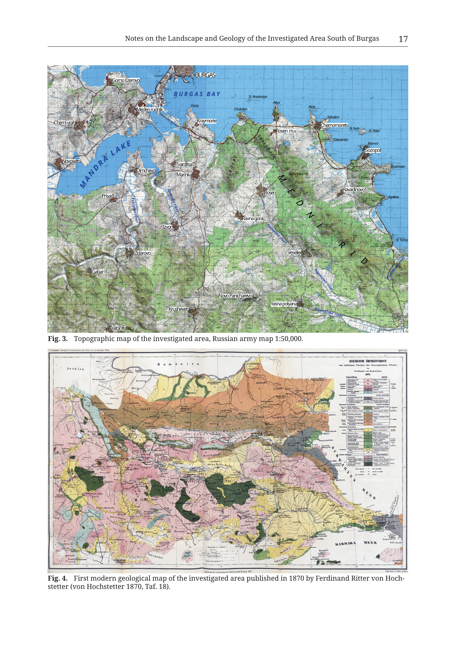
Fig. 3. Topographic map of the investigated area, Russian army map 1:50,000.Map-face place names and hydrographic labels (as printed; English/Latin transliteration style of the Russian army base, with modern/English additions in larger type for key physiographic labels):
Major water bodies:
BURGAS BAY(blue water north-centre / NE)MANDRA LAKE(large elongated blue reservoir/lake west-centre, label curved along the waterbody)- Black Sea (blue field occupying the northern and eastern coastal water; no separate large printed “Black Sea” word required as the water fill is continuous with Burgas Bay)
Major ridge label (large spaced green-field lettering across the Medni Rid upland):
M E D N I(upper line of large spaced capitals across the green ridge)R I D(lower line of large spaced capitals continuing SE along the ridge)
Settlements and localities (as legible, roughly N→S / W→E):
Northern / Burgas Bay sector:
BURGAS(city, north edge, pink urban fill)Gorno EzerovoMeden rudnikCherni vrah(west of Mandra Lake / NW sector)NovoseltsiForosKraymorieChukalyaSt. Anastasya(island in Burgas Bay)AtiyaAkraTalasra[?]Rosen m.v.(mine/works label on the northern Medni Rid spur toward Chernomorets)ChernomoretsSt. Ivan(island)St. Petar(island / rock)SozopolSkamniBudzhakaChervenka
Central Medni Rid / inland:
TvarditsaMarinkaDimchevoPrisadIzvorRosen(village, central green ridge — key study locality)Bakarlaka(hill/locality on the ridge NE of Rosen)Ravna goraRavadinovoAgalinaVeselieSt. Toma(coastal point / cape area SE)
Southern / SW sector:
ZidarovoGabarKrushevetsNovo PanicharevoYasna polyanaVarshilo
Rivers / streams labelled on the map face:
Ropotamo river(SE, flowing toward the Black Sea south of Veselie / Yasna polyana sector)Dyavolska river(further SE near Yasna polyana / southern frame)- Additional blue drainage lines without clearly legible names: feeder streams into Mandra Lake from the south and west; small coastal streams on the Medni Rid seaward flank; a stream system near Zidarovo–Izvor.
Other:
- Green forest/woodland overprint covers much of the Medni Rid upland and patches elsewhere.
- Pink/red urban built-up fills at Burgas and smaller settlement dots/hatches at named villages.
- Brown contour linework across the land; denser on the ridge and hill country.
- Latitude/longitude graticule ticks and fine grid present; individual degree/minute numbers are only partly legible at this render along the frame edges (not securely readable as a full numeric list without risk of digit error — see Notes).
- No separate printed legend box, scale bar, or north arrow is visible inside the Fig. 3 map frame itself; scale is stated in the caption only (
1:50,000). - North is up (standard sheet orientation).
Fig. 4 (lower panel) — historical geological overview map (Hochstetter 1870)
Caption (below map, wraps two lines):
Fig. 4.  First modern geological map of the investigated area published in 1870 by Ferdinand Ritter von Hoch-
stetter (von Hochstetter 1870, Taf. 18).
Title block printed on the original map (upper-right of the historical sheet):
GEOLOGISCHE ÜBERSICHTSKARTE- subtitle line (German, partly small):
des östlichen Theiles der Europäischen Türkei[as legible] Ferdinand von Hochstetter.1870.Legende.(legend header)
Marginal / bordering region labels on the historical map face (German orthography of 1870):
Serbien(west / NW margin)Rumänien(north margin)SCHWARZES MEER(Black Sea, east — large label in the sea)MARMARA MEER(Sea of Marmara, south-east)- Additional city/region names written across the Ottoman European provinces (examples clearly present though many are small): Constantinople / Istanbul area toward SE, Adrianopel / Edirne area, Philippopel / Plovdiv area, Burgas coastal sector, Balkans chain, Rhodopes, etc. (full micro-gazetteer of every 1870 toponym is beyond secure read at this page-render resolution; major waterbody and state-border labels above are secure).
Legend (right side of historical map — German entries).
The legend is a multi-row / multi-column key of coloured boxes and patterned swatches with Fraktur/roman German lithology–age labels. At this book-page render many individual legend lines are ocularly present but only partially resolvable character-by-character. Securely identifiable structural elements of the legend:
- Header:
Legende. - Stacked coloured rectangles (top→bottom / in columns) in colours matching the map face: pale yellow, ochre, orange-brown, pink, rose, green, blue-grey, purple-grey, white/blank with patterns, etc.
- German age/rock terms typical of a Hochstetter-era Balkan overview (as partially readable / standard for this plate — confidently readable fragments include words/roots such as tertiary / Alluvium-class units, Cretaceous-class, Jurassic/Triassic-class, crystalline / schist / eruptive classes).
- Where a full verbatim letter-by-letter legend transcription cannot be guaranteed from this PNG alone, entries are not invented; see Notes.
Map-face geological colouring (descriptive, not a substitute for the full German legend):
- Broad colour belts run roughly W–E to WNW–ESE across the eastern Balkans / European Turkey:
- Northern belt of yellow–ochre–brown sedimentary/younger cover tones along the Danube–Rumänien foreland side.
- Central pink / rose / pale belts across the interior.
- Green and grey-green belts in mountain massifs (Balkan, Rhodope sector).
- Coastal and lowland yellows toward the SCHWARZES MEER and south toward MARMARA MEER.
- Black linework: rivers, coastlines, political/region outlines, mountain hatching.
- The Burgas / Medni Rid coastal sector sits on the western Black Sea shore of this overview (mid-right of the sheet edge toward SCHWARZES MEER) — small at this scale compared to the full eastern-Balkans frame.
Other printed elements on the historical sheet:
- Top margin monochrome border/title ribbon of the original plate.
- Bottom centre: original plate footer line with publication credit (German; includes reference to the Denkschriften / Akademie context and year 1870 — partially legible; caption explicitly cites
von Hochstetter 1870, Taf. 18). - Lower-right corner: lithographer / printer credit line (German, small; includes Wien reference as legible in fragment).
- Scale bar / graphical scale near the bottom centre of the original plate (segmented bar with numeric labels; individual km figures partially legible only).
- Fold lines / paper joins of the original multi-panel plate are visible as vertical seams across the reproduced map.
Description
TYPE & PURPOSE
Book page pairing two complementary orientation figures for the Medni Rid / south-of-Burgas research area:
- Fig. 3 — modern working-area topographic base (Russian army map at 1:50 000) naming the settlements, ridge, lakes, bays, and rivers of the investigated landscape at a field-useful scale.
- Fig. 4 — the first modern geological overview covering the wider eastern Balkans / European Turkey published by Ferdinand Ritter von Hochstetter in 1870 (Tafel 18), reproduced to place the investigated area in the history of geological cartography.
The page sits in the chapter “Notes on the Landscape and Geology of the Investigated Area South of Burgas”. Filename says “1879” but the printed caption states 1870 — 1870 is authoritative for the plate (see Notes).
Fig. 3 — Topographic map of the investigated area (Russian army 1:50 000)
TYPE & PURPOSE
Colour topographic map of the Burgas Bay – Mandra Lake – Medni Rid – Sozopol – Ropotamo coastal block. Purpose: show the investigated terrain at 1:50 000 with relief-lines, forest green, settlements, and named hydrography so later archaeological/geological localities can be paced against a standard topographic frame. Source base: Russian army map 1:50,000 (per caption).
FRAME, EXTENT, ORIENTATION
- Single rectangular map panel occupying the upper half of the page.
- North up; no separate north-arrow glyph is required/visible.
- Extent (from place names):
- N: Burgas city and Burgas Bay, with St. Anastasya island and the Atiya–Chernomorets–Sozopol coastal chain on the eastern bay shore.
- W: Cherni vrah – Novoseltsi – Prisad – Gabar – Varshilo belt west of Mandra Lake.
- S: Varshilo – Krushevets – Novo Panicharevo – Yasna polyana – Dyavolska river sector.
- E: Black Sea coast from Atiya/Chernomorets past Sozopol and Budzhaka to Agalina / St. Toma / Ropotamo mouth area.
- The large spaced label MEDNI RID is written directly across the forested ridge that is the monograph’s physiographic spine.
SCALE
- Stated ratio only: 1:50,000 (caption). No graphical scale bar is printed inside the Fig. 3 frame on this page render.
- At 1:50 000, 1 mm ≈ 50 m on the ground; the frame spans on the order of ~15–25 km E–W and ~15–20 km N–S (visual estimate from known Burgas–Sozopol / Mandra geometry).
COORDINATES / GRID
- Fine geographic graticule/grid is present (light lines).
- Edge tick numbers are not securely legible digit-by-digit on this PNG at the required accuracy; they are not transcribed as invented values (see Notes). Catalogue-style 35T centroid consistency check does not apply (no body-text site centroid on this page).
RELIEF & PHYSIOGRAPHY
- Contours: brown contour linework throughout the land area; denser packing on Medni Rid and on hills west of Mandra Lake (Cherni vrah sector); more open contours on lower ground near Burgas and Zidarovo–Novo Panicharevo.
- Forest overprint: mid-to-dark green woodland screen dominates the Medni Rid massif and extends in patches to Ravadinovo–Veselie–Ropotamo country and west of Mandra.
- Open / cultivated or unwooded ground: pale/tan base without dense green, especially around Burgas lowlands, Mandra shores, Zidarovo–Krushevets corridor, and coastal fringe clearings.
- Medni Rid: NW–SE to N–S elongated forested ridge between Burgas Bay / Mandra system and the outer Black Sea coast at Sozopol–Ravadinovo; Bakarlaka labelled on a high part of the ridge; Rosen village near the central ridge; Rosen m.v. on the northern spur toward Chernomorets.
- No spot-height list is fully legible as a complete catalogue at this render; occasional small elevation numerals exist in the contour field but are not all securely readable.
HYDROGRAPHY & COAST
- Burgas Bay — broad blue embayment on the north edge with Burgas city on its northern shore; islands St. Anastasya, and further east the small rocks/islands St. Ivan and St. Petar off Sozopol.
- Mandra Lake — large elongated inland waterbody west-centre, label along its axis; receives drainage from the SW/S and sits between Cherni vrah–Novoseltsi west and Dimchevo–Marinka–Izvor east.
- Black Sea open coast east of the Chernomorets–Sozopol–Budzhaka–Agalina chain, with indented rocky headlands.
- Ropotamo river — labelled in the SE, draining Medni Rid / Strandza-foreland country to the sea.
- Dyavolska river — labelled near the southern frame by Yasna polyana.
- Smaller blue streams feed Mandra Lake and dissect the Rosen–Zidarovo–Izvor corridors.
ANTHROPOGENIC / CULTURAL FEATURES
- Burgas — principal city, substantial pink urban footprint on the north bay shore.
- Coastal chain of research relevance: Atiya, Chernomorets, Sozopol, Ravadinovo, Budzhaka, Agalina — all named; these recur as catalogue/survey points later in the monograph.
- Rosen and Rosen m.v. — village plus mine/works label on/near the ridge; core of the Rosen ore-field toponymy.
- Meden rudnik (“Copper mine”) — inland of the bay SW of Burgas / N of Mandra, preserving mining-geography memory in the place name.
- Zidarovo, Veselie, Yasna polyana, Novo Panicharevo, Izvor, Marinka, Dimchevo, Prisad, Gabar, Krushevets, Varshilo, Tvarditsa — inland settlement lattice framing the ridge and lake.
- Road and track network as fine black/brown linework linking Burgas to Chernomorets–Sozopol and inland to Zidarovo/Rosen; individual road numbers not clearly keyed.
- No separate archaeological trench/kiln/fortress symbols are printed as a special key on this topo base (it is topographic, not an archaeology plate).
GEOLOGICAL CONTENT
- None as lithological fill. This is topography + land cover + hydrology + settlement.
COLOUR & SYMBOL SYSTEM
- Blue = sea, bay, lake, rivers.
- Green screen = wooded Medni Rid and other woodland.
- Pink = urban fabric (esp. Burgas).
- Brown = contours / some road or bank casings.
- Pale tan/white = open land.
- Black type = toponyms and hydro names.
- Large green-field spaced capitals = MEDNI RID physiographic label.
SPATIAL RELATIONSHIPS
- Medni Rid occupies the peninsula-like upland between Mandra Lake / Burgas Bay (west and north) and the open Black Sea (east), trending south-eastward toward the Ropotamo.
- Rosen sits mid-ridge; Bakarlaka on the ridge crest NE of Rosen; Rosen m.v. toward the Chernomorets end — together the classical Rosen ore-field geographic wedge.
- Sozopol and its islands: mark the rocky coastal tip east of the ridge.
- Zidarovo lies SW of the ridge across lower ground, at the edge of the same metallogenic hinterland treated elsewhere separately as the Zidarovo ore field.
- Cherni vrah west of Mandra Lake is a separate upland node (and a named mining/site locality in the broader collection): but not on Medni Rid itself.
- Relative to Fig. 4: Fig. 3 is the local 1:50 000 working window cut from the same coastal sector that on Hochstetter’s 1870 sheet is only a tiny stretch of the western SCHWARZES MEER shoreline.
RELATIONSHIP TO OTHER FIGURES
- Immediate companion to Fig. 4 on the same page (historical geological context).
- Zooms into the regional frame of the preceding overview map (
Tub_p018_Fig1_Medni_Rid_overview.png, Fig. 2 of the chapter). - Base geography for later Tübingen plates of individual mines, fortresses, and kiln sites around Rosen, Chernomorets, Sozopol, Zidarovo, Ropotamo, etc.
Fig. 4 — Hochstetter 1870 geological overview (first modern geological map cited for the area)
TYPE & PURPOSE
Reproduction of Ferdinand Ritter von Hochstetter’s Geologische Übersichtskarte of the eastern part of European Turkey, 1870, Tafel 18. The monograph caption calls it the “first modern geological map of the investigated area” published in that work. Purpose on this page: historical–scientific orientation — show how the Burgas / Medni Rid coast was first embedded in a modern (1860s–70s) regional geological synthesis, long before detailed Rosen-ore-field maps.
FRAME, EXTENT, ORIENTATION
- Single wide rectangular historical sheet reproduction occupying the lower half of the page.
- North up.
- Geographic span is continental-subregional, far larger than Fig. 3:
- W: toward Serbien (Serbia).
- N: Rumänien (Romania) and the Danube foreland side.
- E: SCHWARZES MEER (Black Sea).
- SE/S: MARMARA MEER (Sea of Marmara) and the approaches to Constantinople / the Straits.
- The “investigated area south of Burgas” is only a small coastal patch on the western Black Sea shore of this overview — not enlarged.
SCALE
- Original plate carries its own graphical scale near the bottom; exact ratio is not restated in the English caption. Ground span is hundreds of kilometres E–W (entire eastern Balkans to the Black Sea and Marmara).
- No 1:50 000-class detail; lithology is broad regional colouring only.
COORDINATES / GRID
- No modern UTM grid. Original interior ticks/graticule if present are subordinate to the geological colouring and not used here for numeric consistency checks; fairly none catalogue centroid applies.
GEOLOGICAL CONTENT
- Polygonal geological colour fill across the whole land area, keyed a German legend at the upper right of the original plate.
- Units are regional age/lithology classes of the 1870 survey tradition (crystalline basement, Mesozoic carbonates/clastics, Tertiary, alluvium, eruptives, etc.) — not the fine Upper Cretaceous volcano-plutonic subdivision of modern Rosen-field maps (Tzankova Fig. 1, later Tübingen structural maps).
- Colour belts form long W–E to WNW–ESE strips parallel to the Balkan orographic grain, with distinct massifs (Balkan range, Rhodope block, coastal and interior basins) picked out by contrast of greens, pinks, yellows, and browns.
- Coast of the SCHWARZES MEER and MARMARA MEER drawn in black shoreline; Black Sea is uncoloured/pale paper within the sea area outside geological land colors.
- Rivers in black. fine linework.
- No mine-pick deposit symbols for Rosen / Meden Rid are expected or securely visible at this overview scale.
LEGEND
- Located upper-right under
Legende. - Multi-entry coloured box key in German.
- Exhaustive line-by-line verbatim transcription is not fully recoverable at the resolution of this book-page PNG without fabricating characters. The legend’s presence, language (German), position, and role (age/lithology → colour) are certain; individual entry strings that cannot be read with high confidence are left unclaimed rather than guessed (per VISION-PROMPT non-hallucination rule). If a higher-resolution original plate is later available, the legend should be re-transcribed entry-by-entry.
STRUCTURAL / OTHER SYMBOLS
- Mountain hachures and some tectonic/orographic hints via the geological colour boundaries.
- No modern fault-tick key comparable to late-20th-century deposit maps.
ANTHROPOGENIC / CULTURAL
- Period toponyms in German or local orthography (cities, regions).
- State/region labels: Serbien, Rumänien; sea names SCHWARZES MEER, MARMARA MEER.
- No 21st-century roads or archaeological overlays (it is an 1870 geological overview).
SPATIAL RELATIONSHIPS
- Places the Burgas coast on the western rim of the Black Sea within a single geological canvas that also reaches the Danube lands, interior Thrace, the Rhodopes and the Marmara.
- Shows that “first modern” geological treatment of the investigated area was as a marginal coastal cell of a provincial Ottoman-European synthesis, not as a stand-alone Rosen ore-field sheet.
- Contrast with Fig. 3: Fig. 4 = macro regional geology history; Fig. 3 = micro topographic working area.
RELATIONSHIP TO OTHER FIGURES
- Same-page companion to Fig. 3.
- Historical predecessor context for all later detailed geological maps in the volume (e.g. Tübingen structural maps of Rosen, Varli Bryag, Zidarovo ore fields; Tzankova 2023 Fig. 1).
- Citation form locked by caption: von Hochstetter 1870, Taf. 18.
Notes
- Date discrepancy: filename
...1879...vs printed caption “published in 1870” and on-plate year 1870. Trust the printed caption/plate: 1870. Filename year is likely a slip. - Page number: header prints 17; filename
Tub_p019is the PDF-page offset used by the extractor, not the printed folio. - Fig. 3 graticule numeric edge labels are not fully and safely readable at this render; left untranscribed rather than guessed (a wrong tick would misplace the sheet by kilometres).
- Fig. 4 German legend: fully verbatim entry list not guaranteed at this resolution; described structurally. Do not treat the description as a complete OCR of Hochstetter’s legend.
- Spellings on Fig. 3 follow the printed Russian-army/English hybrid forms (e.g.
Yasna polyana,Novo Panicharevo,Meden rudnik,Cherni vrah) and are transcribed as seen, not silently modernised to contemporary Bulgarian orthography. - No UTM catalogue centroid consistency check applies to either figure.
- None further.