Description
Transcription
Page header
- Top-left:
16 - Top-centre:
Kalin Dimitrov - Horizontal rule under header.
Fig. 1 (upper panel) — caption (right of photograph)
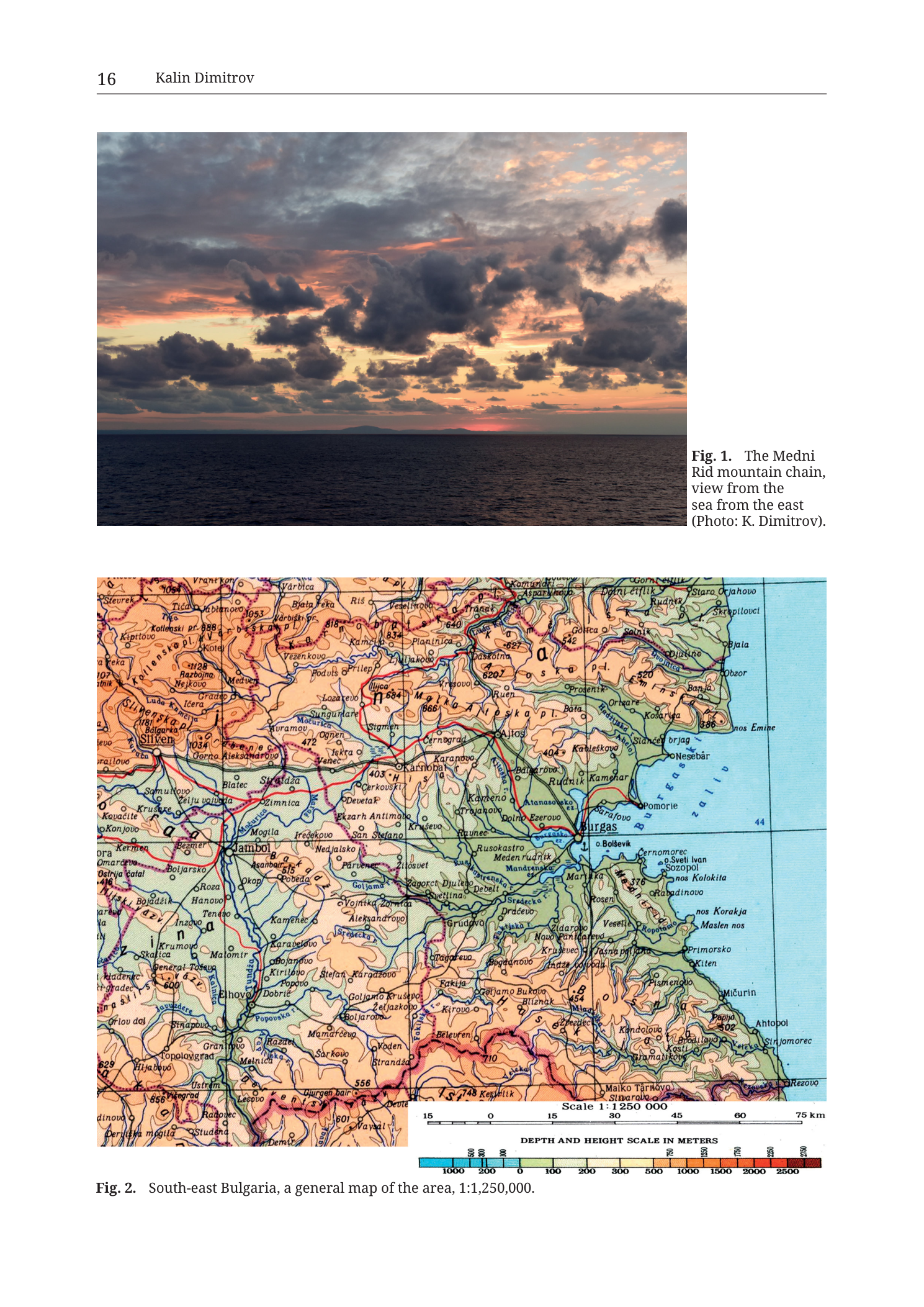
Fig. 1.  The Medni
Rid mountain chain,
view from the
sea from the east
(Photo: K. Dimitrov).
No labels, scale bar, north arrow, or text overprinted on the photograph itself.
Fig. 2 (lower panel) — full-page topographic/hypsometric map
Caption (below map, left-aligned):
Fig. 2. South-east Bulgaria, a general map of the area, 1:1,250,000.Scale bar (bottom-centre of map face):
- Label:
Scale 1 : 1 250 000 - Numeric ticks on bar:
15|0|15|30|45|60|75 km - Bar is segmented (alternating dark/light blocks) from 15 km left of 0 through 0 to 75 km.
Depth and height colour scale (below the linear scale bar):
-
Header:
DEPTH AND HEIGHT SCALE IN METERS -
Colour ramp left → right (bathymetry blues → land hypsometric tints), with numeric labels:
Bathymetry (blue, left of 0):
1000(deepest blue)2000(sea level / coastline transition)
Land elevations (right of 0):
100(pale yellow-green)200(pale yellow)300(yellow)500(ochre / light orange)1000(orange)1500(red-orange)2000(red)2500(dark red / maroon)
Map-face place names, elevation spot-heights, hydrography labels, and coastal features (transcribed as legible from the printed map, roughly NW→SE / by region; many small toponyms are dense and partly crushed at this render resolution — illegible ones marked):
Western / inland upland sector (left side of map):
- Sliven (city)
- Siliven (?) plateau labels; Kotlenska pI. / Kotlenska pl. (plateau label across NW uplands)
- Varbica / Varbica area
- Sevrek [?], Kipilovo, Kotel
- Mokren, Neykovo, Gradec, Ichera, Luda Kamcija (river system traces)
- Tvardica area; Elena / Elena Balkan fringe labels toward NW edge
- Elevation spots (selected legible): 1084, 1053, 838, 834, 688, 684, 666, 640, 627, 620, 600, 556, 548, 515, 507, 502, 454, 416, 403, 404, 386, 376, and others partially legible
- Topolovgrad, Hlyabovo, Ustrem, Radovec, Studena, Derutha mogila [?]
- Elhovo, Dobric, Popovo, Krumovgrad-ward SW labels fringe off-map West conventions
- Jambol (city; also spelled Yambol on some sheets — here “Jambol”)
- Nova Zagora / Zagora sector to south-central: Zlatusa, Goliamo, Debel, Parvenec, etc.
- Karnobat (city)
- Aitos (city; printed “Aitos”)
- Karnobatska / Karnobat area hills
- Straldza, Blatec, Zimnica, Mogila, Nedjalsko, Irechekovo
- Samuilovo, Zhelju vojvoda, Kermen / Kermen area, Bolyarovo, Hanovo, Topolovka sector
- Elensko / Dervent / Strandza-foreland toponyms toward the south: Mamarcevo, Sarkovo, Vodeni, Strandza labels, Belevren, Kirovo, Goliamo Bukovo, Bliznak, Zabernovo, Malko Tarnovo
- Sredets, Grudovo, Debelt (area), Svetlina, Rusokastro, Meden rudnik (“Meden rudnik” — copper-mine place name inland of Burgas)
- Rosen (village; south of Burgas / inland of Chernomorets–Sozopol belt — key study-area toponym)
- Zidarovo, Krusevo, Yasna poljana / Jasna poljana, Veselie, Novo Panicharevo, Izvor
- Primorsko, Kiten, Lozenets / Lozerec area, Carafovo fringe, Carfovo, Varvara, Ahtopol, Sinemorec, Rezovo (southern Black Sea coastal chain)
- Michurin (Tsarevo; older name “Michurin” preserved on this sheet)
- Bouyna / Fazanovo / Kondolovo / Bulgari / Gramatiikovo / Malko Tarnovo Strandza sector
Northern Black Sea coast / NE sector:
- Staro Oryahovo, Shkorpilovtsi, Byala, Obzor
- Cape Emine (printed “nos Emine”)
- Nesebar (printed “Nesebar”)
- Sunny Beach / adjoining resorts partially labelled (Slanchev bryag area)
- Pomorie
- Burgas (city; major hub, printed “Burgas”)
- Lake/lagoon complex at Burgas indicated by blue water-bodies (Burgas Lake system)
- o. Bolshevik (island label NE of Burgas bay; historical name iso.)
- Chernomorets (printed “Cernomorec”)
- Sveti Ivan (island label)
- Sozopol
- nos Kolokita (Cape Kolokita)
- Rabishko / Ravadinovo
- nos Korakja (Cape Korakya)
- Maslen nos (Cape Maslen nos)
Hydrography (selected named / clearly traced):
- Black Sea (blue field occupying entire eastern third of the map; no large printed “Black Sea” word is required as the waterbody fill is self-evident, but bathymetric blue tint is continuous)
- River network in blue linework across whole land area (Kamchiya system north, Luda Kamchiya, Fakiyska, Ropotamo, Veleka, Rezovska and many unnamed tributaries). Individual river name labels that are legible include fragments of Kamchiya-basin names in the north and Strandza-coastal streams in the south (Ropotamo sector near Primorsko–Kiten; Veleka toward Sinemorec–Ahtopol; Rezovska at the southern edge near Rezovo).
- Coastal lagoons / lakes around Burgas drawn as blue closed water-bodies.
Roads / infrastructure (as drawn, not fully annotated):
- Red and black road casings form a network linking Sliven–Jambol–Karnobat–Aitos–Burgas and coastal laterals; a heavier red route traces the main inland corridor. Individual road numbers are mostly too small to read reliably at this render; where digits appear near Burgas a small “44” is legible offshore/near the bay annotation area (likely a route or sheet reference — transcribed as printed “44”).
Relief / contour bills:
- Brown contour linework densifies in the NW Balkan / Kotel–Sliven mountains and in the Strandza hills south of Burgas–Malko Tarnovo; sparser contours on the Burgas lowland and coastal plain.
- Hypsometric fill colours follow the DEPTH AND HEIGHT SCALE (greens/yellows on low coastal plain and Burgas lowland; oranges on Sredna Gora / Balkan foothills and Strandza high ground; deep reds only at highest NW mountain spots).
International / sheet edges:
- Southern edge approaches the Turkish border sector (Resovo / Rezovo area) without a heavy printed “Turkey” label on this crop.
- Northern edge cuts through the Kamchiya–Byala coastal strip; western edge through the Sliven–Elhovo longitudes.
- No printed latitude/longitude graticule numbers or UTM ticks are legible on this render (a light grid of fine black lines crosses the map — perpendicular N–S / E–W sheet grid — but numeric coordinate labels are not clearly readable at the frame edges).
Description
TYPE & PURPOSE
This is a full book page (Kalin Dimitrov chapter opener) combining:
- Fig. 1 — an east-looking seascape photograph of the Medni Rid mountain chain silhouette at sunrise/sunset, establishing the physiographic identity of the study ridge as seen from the Black Sea.
- Fig. 2 — a small-scale (1:1 250 000) general topographic / hypsometric reference map of south-east Bulgaria, situating Medni Rid, Burgas, Sozopol, Rosen, the Strandza, and the Balkan foothills in regional context.
Together the two figures introduce the reader to the landscape (photo) and the broader geographic frame (map) before more detailed geological and archaeological plates in the monograph.
Fig. 1 — Photograph: Medni Rid from the sea (east)
What is shown. A wide seascape photograph taken from a vessel or low coastal viewpoint on the Black Sea, looking west toward land, so that the Medni Rid mountain chain appears as a low, dark horizontal silhouette on the distant horizon. The caption states the viewpoint explicitly: “view from the sea from the east”.
Sky / lighting.
- Dramatic dawn or dusk sky: dense stratocumulus and cumulus cloud deck occupying the upper two-thirds of the frame.
- Cloud bases and mid-levels are dark grey to blue-grey; cloud edges and breaks are lit warm orange, peach, and pale gold by a low sun (below or near the horizon behind/near the ridge).
- Colour gradient in open sky patches runs from cool blue-grey upper left to warm amber along the horizon band.
- No sun disk is directly visible; illumination is back-light / side-light on cloud bases (classic “golden hour” maritime light).
Sea.
- Dark, lightly textured water surface filling the lower third of the frame.
- Gentle swell with low-amplitude ripples; no whitecaps dominant.
- No boats, buoys, or foreground structures are visible — open water only.
Land / Medni Rid silhouette.
- A long, low, continuous dark landform stretches across the centre horizon from roughly left-of-centre to right-of-centre.
- Profile is gently undulating: multiple low summits and saddles rather than a single sharp peak — consistent with a ridge/chain rather than an isolated mountain.
- The chain sits low above the sea horizon (angular height small), matching the modest absolute elevations of Medni Rid (hundreds of metres, not alpine).
- No individual peaks are named on the photograph; identification as “Medni Rid mountain chain” rests entirely on the caption and chapter context.
- Shoreline details, beaches, settlements (Sozopol, Chernomorets, etc.) are not resolved — distance and atmospheric silhouetting reduce the land to pure outline.
Orientation / framing.
- Camera faces west (from sea toward land from the east).
- No north arrow, no scale, no overprinted labels.
- Horizon is nearly level; slight waterline is straight across the lower third.
- Aspect ratio is a wide landscape rectangle set on the upper half of the book page, with caption typeset to its right in the outer margin.
Purpose of the photograph in the argument. Aesthetic and geographic orientation: shows Medni Rid as a coastal-facing ridge visible from the Black Sea, grounding later geological/mining discussion in a recognisable landscape image. Photo credit: K. Dimitrov.
Fig. 2 — Topographic / hypsometric map of south-east Bulgaria
TYPE & PURPOSE
Small-scale general reference map of SE Bulgaria at stated ratio 1:1 250 000. Purpose: locate the Burgas–Sozopol–Medni Rid–Strandza research region within the broader SE Bulgarian landscape, showing relief (hypsometry + contours), drainage, main settlements, road network, and Black Sea coast configuration. It is not a geological map (no lithology colours, no deposits, no faults keyed).
FRAME, EXTENT, ORIENTATION
- Single rectangular map panel occupying the lower two-thirds of the page.
- Orientation: north is up (standard sheet orientation; no separate north arrow is printed).
- Approximate geographic extent (from place names):
- West: Sliven–Jambol–Elhovo–Topolovgrad longitudes (inland Upper Thracian / Tundzha country and Sredna Gora / Balkan foreland).
- East: Black Sea coast from roughly Byala / Staro Oryahovo south to Rezovo (Bulgarian–Turkish border coast).
- North: Kamchiya basin / eastern Balkan foothills / Byala–Obzor coast.
- South: Strandza Mountains and southern Black Sea towns (Ahtopol, Sinemorec, Rezovo) approaching the frontier.
- A light rectangular grid of fine black lines (sheet grid) crosses the map; numeric geographic coordinates are not clearly legible at the frame edges on this PNG render.
- No inset location map.
SCALE
- Explicit ratio: 1 : 1 250 000 (printed both in the scale-bar label and in the figure caption).
- Graphical scale bar: from 15 km left of zero through 0 to 75 km, labelled in kilometres.
- Ground distance across the full map frame E–W is on the order of ~200+ km (visual estimate against the 75 km bar, which spans roughly one-third of the frame width); N–S similar order.
COORDINATES / GRID
- Fine black grid lines present, approximately orthogonal.
- No clearly readable UTM eastings/northings or lat/long tick numbers on this render.
- Consistency-check centroid procedure (catalogue 35T E/N) does not apply — this is a regional overview map, not a catalogue site plate.
RELIEF & PHYSIOGRAPHY
Rendering method:
- Hypsometric tint (land) + bathymetric tint (sea) per the printed DEPTH AND HEIGHT SCALE IN METERS.
- Brown contour linework over the hypsometric fill; contour density highest in mountainous sectors.
- Spot heights (black elevation numbers in metres) at selected peaks/high points.
Major landforms (observed from tints, contours, and place names):
- Eastern Balkan / Kotel–Sliven mountains (NW of map): highest land tints (oranges into reds), dense contours, spot heights above 1000 m (e.g. 1084, 1053). Forms the NW high corner.
- Burgas lowland and coastal plain (centre-east): pale yellow-green hypsometric tints, sparse contours, low spot heights — the low-lying corridor around Burgas, the Burgas lakes, and the coastal strip toward Pomorie–Nesebar north and Chernomorets–Sozopol south.
- Medni Rid / Rosen coastal ridge sector (immediately inland of Sozopol–Chernomorets–Primorsko stretch): a subtle N–S to NW–SE belt of slightly higher ground between the Burgas lowland and the Strandza proper; the village Rosen is labelled in this belt south of Burgas / west of the Sozopol peninsula zone. The Medni Rid chain of Fig. 1 is this near-coast ridge system (not a high alpine range — consistent with the modest silhouette in the photograph).
- Strandza Mountains (south / SE inland): broader elevated country south of Sredets–Zidarovo–Malko Tarnovo, with orange hypsometric tints, denser contours, and spot heights into the several-hundred-metres range (e.g. 556, 548, 507, 502, 454). Drains to the southern Black Sea via Ropotamo, Veleka, Rezovska and related streams.
- Sredna Gora / Bakadzhik and intermediate hills west of Burgas: Karnobat–Aitos hill country as intermediate oranges between the NW mountains and the Burgas plain.
Elevation range:
- Sea bathymetry shown down to 1000 m depth (deepest blue on the scale).
- Land scale runs 0 → 2500 m; on this particular sheet the highest printed spot heights in-frame are a little above 1000 m in the NW mountains; Strandza and Medni Rid remain well below the upper red classes.
HYDROGRAPHY & COAST
- Black Sea fills the entire eastern side in continuous blue bathymetric tint, with depth classes per the scale (0 / 200 / 1000 m). Nearshore waters are lighter blue; deeper offshore tones darken.
- Coastline is intricately drawn:
- Burgas Bay re-entrant with the Burgas lake/lagoon complex.
- Nesebar–Pomorie headlands north of Burgas.
- Cape Emine (“nos Emine”) as a sharp projection.
- Sozopol peninsula / island complex (Sveti Ivan labelled).
- Capes Kolokita, Korakya, Maslen nos south of Sozopol.
- Secondary bays at Primorsko, Tsarevo (Michurin), Ahtopol, and the Rezovo mouth.
- Rivers: dense blue drainage network. Major systems visible by geometry even where name labels are partly illegible:
- Northern Kamchiya-basin drainage to the Black Sea north of Byala/Obzor.
- Larger inland tributaries of the Tundzha / Maritsa direction off the west edge.
- Ropotamo near Primorsko–Kiten.
- Veleka toward Ahtopol–Sinemorec.
- Rezovska at the southern border coast near Rezovo.
- Burgas lakes drawn as closed blue water polygons next to the city.
ANTHROPOGENIC / CULTURAL FEATURES
Major cities / towns (selected, as labelled):
| Region | Named settlements (as printed / clearly legible) |
|---|---|
| NW inland | Sliven, Kotel, Tvardica area, Straldza, Zimnica |
| West-central | Jambol, Elhovo, Topolovgrad, Bolyarovo, Kermen area |
| North-central | Karnobat, Aitos, Karnobat hill villages (Karlanovo etc.) |
| Burgas node | Burgas, Dolno Ezerovo, Kameno, Balgarovo, Rudnik, Kableshkovo |
| N coast | Byala, Obzor, Nesebar, Pomorie, Slanchev bryag area |
| Medni Rid / S coast study area | Chernomorets (Cernomorec), Sozopol, Ravadinovo, Rosen, Zidarovo, Veselie, Yasna poljana, Meden rudnik, Primorsko, Kiten |
| Strandza / S coast | Malko Tarnovo, Tsarevo (Michurin), Ahtopol, Sinemorec, Rezovo, Lozenets/Lozerec, Varvara |
| S inland Strandza | Sredets, Grudovo, Kirovo, Goliamo Bukovo, Bliznak, Belevren, Kondolovo, Bulgari, Gramatiikovo |
Road network: red primary and black/grey secondary road casings interconnect the city chain Sliven–Jambol–Karnobat–Aitos–Burgas and radiate to the coast and Strandza. No railway key is separately printed as a legend item on this figure (rail casings may be present in the linework but are not distinctly keyed).
No archaeological site symbols, mine-pick symbols, sample points, or fortress markers are keyed on Fig. 2 — it is purely a general geographic base. (Mining relevance is implicit only via place names such as Meden rudnik = “Copper mine” and Rosen, which reappear as researched localities elsewhere in the monograph.)
GEOLOGICAL CONTENT
- None as a keyed geological layer. No rock-unit colours, no fault traces as a symbol class, no ore-deposit symbols, no stratigraphy.
- Physiographic expression of geological structure is only indirect (e.g. Strandza and Balkan uplands vs Burgas depression).
COLOUR & SYMBOL SYSTEM
- Sea: blue bathymetric ramp (deep navy at 1000 m → cyan/light blue at 0).
- Land hypsometry: green-yellow (low) → yellow → ochre → orange → red → dark red (high), matching the printed metre classes 100 / 200 / 300 / 500 / 1000 / 1500 / 2000 / 2500.
- Contours: brown.
- Hydrography hit (rivers, lakes): blue linework and fills.
- Roads: red (main) and darker thin casings (secondary).
- Settlement names: black roman type, size graded by importance (Burgas, Sliven, Sozopol, etc. larger / bolder).
- Spot heights: small black numerals (metres).
- No separate legend box beyond the depth/height colour ramp and the scale bar.
SPATIAL RELATIONSHIPS (regional)
- Burgas sits at the head of Burgas Bay as the central coastal hub; the Burgas lakes lie immediately west/north-west of the city.
- Medni Rid / Rosen -belt lies south of Burgas along the near-coastalridge between the Bay and the Strandza, inland of Chernomorets–Sozopol–Maslen nos. The village Rosen is explicitly labelled in this strip — the same Rosen ore-field locality treated throughout the collection.
- Sozopol occupies the rocky peninsula south of Chernomorets; cape and island labels (Kolokita, Sveti Ivan, Korakya, Maslen nos) mark the intricate ria-like coast immediately east of Medni Rid.
- Strandza rises south and inland of the Rosen–Zidarovo–Primorsko line, culminating toward Malko Tarnovo and the southern border streams (Veleka, Rezovska).
- Eastern Balkan / Kotel–Sliven mountains form the high NW frame, separated from the Strandza by the Burgas lowland and the Tundzha–Sredetska low corridors.
- Main road spine connects the inland chain (Sliven–Jambol–Karnobat–Aitos) to Burgas and then fans along the coast; this is the modern access geography for any field campaign in the Medni Rid ore field.
- Relative to Fig. 1: the photograph looks west from offshore so that the Medni Rid silhouette is exactly the low coastal ridge drawn on Fig. 2 between Burgas Bay and the Strandza coast around Sozopol–Primorsko.
RELATIONSHIP TO OTHER FIGURES
-
Page-pair introduction to the Kalin Dimitrov contribution in Krauss et al. (Eds, 2020), Tübingen University Press monograph on Medni Rid / SE Bulgarian archaeometallurgy and geology.
-
Fig. 1 provides the landscape view of the ridge that Fig. 2 locates cartographically.
-
Subsequent Tübingen figures in this folder (geological maps, site catalogue plates, cross-sections, LiDAR/topographic close-ups of Cherni Vrah, Kyumyurlaka, etc.) sit inside the regional frame established here — especially around the labelled settlements Rosen, Sozopol, Chernomorets, Zidarovo, Primorsko).
-
Filename
Tub_p018_Fig1_Medni_Rid_overview.pngreflects PDF page offset; the printed page number on the sheet is 16.
Notes
- No UTM/catalogue centroid consistency check applies (regional overview map without site-centroid coordinates or labelled map-axis E/N ranges).
- Many small village names and some river names on Fig. 2 are at the legibility limit of this PNG render; transcription above lists clearly readable major settlements and selected spot heights, and flags denser microtoponymy as only partly resolved. Illegible micro-labels were not invented.
- Spot-height digits and a few inland village spellings may include ±1 character uncertainty where contour/type collide; major city names (Sliven, Jambol, Karnobat, Aitos, Burgas, Sozopol, Primorsko, Malko Tarnovo, Ahtopol, Rezovo, Rosen) are secure.
- Historical/older exonyms preserved on the sheet (e.g. “Michurin” for Tsarevo;-e “o. Bolshevik”; “Jambol” transliteration) are transcribed as printed.
- Fig. 1 contains no map elements; all cartographic content is Fig. 2.
- Page author line “Kalin Dimitrov” identifies the chapter author; monograph editorship is Krauss et al. 2020 per collection sourcing.
- None further.