Description
Transcription
North arrow (upper-left corner of map frame): open arrowhead triangle pointing up, labelled “N”.
Map unit labels printed on the face of the map (left-to-right / top-to-bottom as visible):
- sK₂ — in the orange plutonic body near the NW coast
- tkK₂ — in the dark-green tuff belt on the western side of the ore-deposit chain
- EK₂ — in the peach monzonite belt inland of Chernomorets
- Rosen — place/deposit label next to the northernmost red crossed-picks symbol
- Korucheshme — place/deposit label next to the second red crossed-picks symbol
- Meden Rid — place/deposit label next to the third red crossed-picks symbol
- Sarneshko Kladenche — place/deposit label next to the fourth red crossed-picks symbol
- Propadnala Voda — place/deposit label next to the southernmost red crossed-picks symbol
- zK₂ — in the light-green tuff belt just west/south-west of Propadnala Voda / south of Sarneshko Kladenche
- ktK₂ — in the teal tuff unit at the far SW edge of the map
- drK₂ — in the medium-blue tuff unit just east of ktK₂, SW of the deposit chain
- szψtK₂ — in the pale-blue alkaline-trachyte unit near the southern coastal/bay area (label printed as szψtK₂ with psi)
- Chernomorets — settlement name (with red filled circle east of the monzonite/syenite inland belt)
- Sozopol — settlement name (with red filled circle on the eastern peninsula)
Inset location map (upper-right, within map frame): outline of Bulgaria; red pin/rectangle on the SE Black Sea coast; label “Rosen ore field” with a leader arrow pointing to the red marker.
Scale bar (bottom-left edge of map frame):
- Label: “km”
- Tick marks and numbers: 0.5 | 0 | 1 | 2 | 3 | 4 | 5 | 6
- (The bar has a half-kilometre segment left of 0, then whole-kilometre segments from 0 to 6.)
LEGEND (right of map, reading top → bottom):
LEGEND:
- ■ (light grey / pale fill) — Quaternary
- ■ (medium grey fill) — Neogene
Upper Cretaceous
- EK₂ (pale peach / light orange box) — Monzonite
- sK₂ (medium orange box) — Syenite, Quartz-syenite
- zK₂ (light green box) — Zhivizliyska unit (tuff)
- tkK₂ (medium/dark green box) — Tiklitska unit (tuff)
- szψtK₂ (very pale blue box) — Alkaline trachytes
- drK₂ (medium blue box) — Drachevska unit (tuff)
- ktK₂ (teal / dark cyan box) — Kartalkuska unit (tuff)
- ✕ (red crossed-picks / hammer-and-pick mine symbol) — Ore deposit
- ● (solid red circle) — Settlement
No figure caption text is printed on this cropped figure image itself (caption exists only on the parent journal page, not in this PNG).
No coordinate-grid ticks, no UTM/lat-long numbers, no contour values, no fault-symbol key entries beyond the rock-unit and symbol list above.
Description
TYPE & PURPOSE
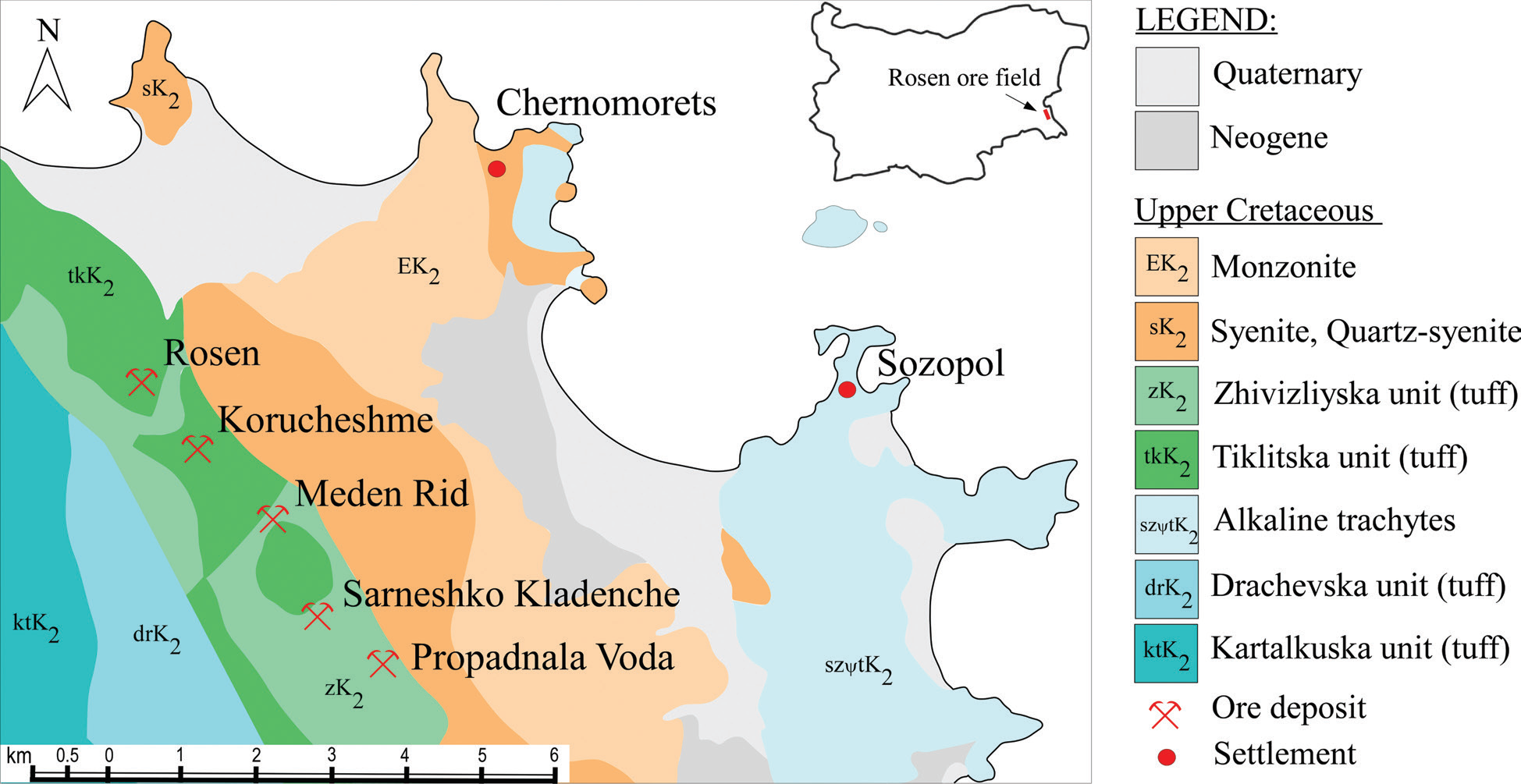
This is a simplified geological map of the Rosen ore field (SE Bulgaria, Burgas ore district / Black Sea coast). Its purpose is to locate the five named copper deposits that have past mining activity against the Upper Cretaceous volcano-plutonic and younger cover units of the Medni Rid–Rosen area, and to place the field geographically via a national inset. The map focuses on lithostratigraphic/plutonic unit distribution and deposit/settlement locations; it does not show structural attitudes, fault traces as a keyed class, mineralization stages, or sample points.
FRAME, EXTENT, ORIENTATION
- Single rectangular map panel occupying the left/centre of the figure; rectangular legend column on the right.
- Orientation: north is up. A simple open north arrow (triangle with shaft, labelled “N”) sits in the upper-left corner of the map frame.
- Geographic setting inferable from shoreline shape and place names: the western Black Sea coast of SE Bulgaria, including the Sozopol peninsula/bay complex and the Chernomorets embayment north of it. The mapped landmass is the coastal–near-coast strip hosting the Medni Rid / Rosen hills inland of that coast.
- No printed coordinate system, projection name, grid, or graticule. No lat/long or UTM ticks.
SCALE
- Graphical scale bar at bottom-left: labelled “km”, with ticks at 0.5, 0, 1, 2, 3, 4, 5, 6.
- No ratio scale (e.g. 1:50 000) is printed.
- Represented ground distance: the bar alone spans 6.5 km (0.5 km left of zero plus 0→6 km). Across the full map frame the coast-to-inland width and N–S length are several times that bar; the deposit chain from Rosen to Propadnala Voda spans on the order of ~4–5 km along strike (visual estimate against the 6 km bar), and the full frame covers roughly on the order of ~15–20+ km E–W including the Sozopol peninsula (visual estimate only; not a surveyed measurement).
COORDINATES / GRID
- None printed. No grid lines, no coordinate ticks, no zone designation.
RELIEF & PHYSIOGRAPHY
- No contours, no hillshade, no hypsometric tint, no elevation labels.
- Physiography is implied only by lithology belts and coastline: a NW–SE-aligned inland belt of green tuffs and orange plutonic rocks (the ridge/hill country of Medni Rid / Rosen) parallel to the coast, with grey Quaternary/Neogene cover toward the shoreline and pale-blue alkaline trachytes toward the SE coastal sector.
HYDROGRAPHY & COAST
- Black Sea coastline drawn as a continuous black shoreline outline, with white (uncoloured) sea.
- Major embayments/peninsulas:
- Northern embayment associated with Chernomorets (settlement marked on its southern/inner shore side of the bay).
- Large eastern bay/peninsula complex labelled Sozopol, with the settlement dot on the neck/peninsula occupied by pale-blue alkaline trachyte and grey cover units.
- Small islands or islet outlines appear off the Sozopol/coast sector (unlabelled, uncoloured or pale).
- No named rivers, lakes, or springs are labelled.
ANTHROPOGENIC / CULTURAL FEATURES
Settlements (red filled circles):
- Chernomorets — northern coastal settlement, inland/short of the northern bay shore, on/near the contact of peach monzonite (EK₂) with orange syenite and grey cover.
- Sozopol — eastern coastal settlement on the peninsula complex, on pale-blue alkaline trachyte / coastal cover.
Ore deposits (red crossed-picks / mine symbols) — five, aligned roughly NW→SE along the green tuff belt inland of the orange plutonic ribbon:
- Rosen — northwesternmost mine symbol, in/near medium-green Tiklitska unit (tkK₂) / light-green Zhivizliyska unit (zK₂) belt, labelled “Rosen”.
- Korucheshme — next SE of Rosen, same green tuff belt, labelled “Korucheshme”.
- Meden Rid — middle of the chain, green tuff belt adjacent to the orange syenite ribbon to the NE, labelled “Meden Rid”.
- Sarneshko Kladenche — SE of Meden Rid, still in the green belt near the orange contact, labelled “Sarneshko Kladenche”.
- Propadnala Voda — southeasternmost mine symbol of the chain, in/near the light-green zK₂ belt at the SE end of the green ribbon, labelled “Propadnala Voda”.
No roads, buildings, fortresses, shafts, adits, spoil heaps, or archaeological trenches are drawn as separate symbols.
GEOLOGICAL CONTENT — MAPPED UNITS (legend order)
Younger cover (no subscript age code beyond name):
- Quaternary — light grey / very pale grey fill. Forms discontinuous coastal and lowland strips: notably a broad pale band inland of the Chernomorets–central coast, patches around the Sozopol area, and other fringe polygons adjacent to older rocks.
- Neogene — medium grey fill. Occurs as coastal/near-coast polygons, including a substantial grey body along the central coast between the plutonic belt and the sea, and other grey patches near Sozopol and the southern map edge.
Upper Cretaceous — intrusive (plutonic):
- EK₂ — Monzonite — pale peach / light orange. Forms an elongated belt inland (SW of Chernomorets, NE of the main syenite body in places), labelled EK₂ on the map face north-central open.
- sK₂ — Syenite, Quartz-syenite — medium orange. The dominant orange plutonic body: a large NW–SE elongated mass forming the inland orthostatic core of the field NE of the green tuff belt; also a separate smaller orange sK₂ body at the far NW coast with the sK₂ label printed on it. Hosts/ abuts much of the NE side of the deposit chain.
Upper Cretaceous — volcanic / volcano-sedimentary tuff units and related:
- zK₂ — Zhivizliyska unit (tuff) — light green. Forms part of the NW–SE green belt hosting the deposits; labelled zK₂ near Propadnala Voda / south-west edge of the deposit chain. (Legend colour is light green.)
- tkK₂ — Tiklitska unit (tuff) — medium to dark green. Major host stripe of the deposit alignment on the western side of the orange pluton; labelled tkK₂ on the western green area near Rosen. Closely interleaved with zK₂ along the ore chain.
- szψtK₂ — Alkaline trachytes — very pale blue / ice blue. Extensive unit occupying much of the SE and eastern coastal sector around and south of Sozopol, extending into peninsulas and coastal outcrops; labelled szψtK₂ in the southern coastal pale-blue field. (The printed subscript on the map face is szψtK₂ matching the legend.)
- drK₂ — Drachevska unit (tuff) — medium blue. Present on the SW side of the map as a blue band between teal ktK₂ and the green zK₂/tkK₂ belt; labelled drK₂ west-southwest of Sarneshko Kladenche / Propadnala Voda.
- ktK₂ — Kartalkuska unit (tuff) — teal / dark cyan. Occurs at the far SW map margin west of drK₂; labelled ktK₂ at left edge.
STRUCTURAL SYMBOLS
- No keyed fault, fold, bedding-dip, foliation, joint, shear-zone, aureole, or vein symbols appear in the legend.
- Unit contacts are drawn as smooth curved solid black boundaries between colour polygons. Contact geometry is simplified (not a structural map).
- The dominant geometric fabric of the bedrock belts is NW–SE elongation: orange syenite/monzonite ribbon and green tuff ribbon run parallel, NW–SE, parallel to the overall trend of the five ore deposits.
ORE BODIES / DEPOSITS
All five classic Rosen-field deposits of the paper’s study set are shown with the mine-pick symbol, NW→SE:
- Rosen
- Korucheshme
- Meden Rid
- Sarneshko Kladenche
- Propadnala Voda
They form a nearly linear NW–SE chain sitting preferentially in the green Upper Cretaceous tuff belt (tkK₂ / zK₂), immediately SW of / along the contact with the orange syenite–quartz-syenite (sK₂) body. Meden Rid’s label sits beside a slightly inflated green lobe indenting the orange pluton. No deposit is marked inside the pale-blue alkaline trachytes, the grey Neogene/Quaternary cover, or the far-SW teal ktK₂ alone.
Alternate names known from the broader literature (e.g. Bakarlak for Meden Rid, Kyumyurlaka/Stahanov for Korucheshme, Červeno Zname for Propadnala Voda) are not printed on this figure.
SAMPLE / LOCALITY POINTS
- None other than the two settlement dots and five deposit symbols. No borehole, geochem-sample, or thin-section number series.
CROSS-SECTION TRACES
- None (no A–A′, B–B′ lines).
STRATIGRAPHIC / LEGEND COLUMN
- Legend is a simple stacked key (not a thickness column): Quaternary → Neogene → Upper Cretaceous units (EK₂, sK₂, zK₂, tkK₂, szψtK₂, drK₂, ktK₂) → ore-deposit symbol → settlement symbol.
- No thicknesses, no unconformity glyphs, no time-scale bar.
COLOUR & SYMBOL SYSTEM
- Fill colours encode age/lithology classes as listed above.
- Greys = Cenozoic cover (lighter = Quaternary, mid = Neogene).
- Warm peach/orange = Upper Cretaceous intermediate–felsic plutonics (monzonite vs syenite/quartz-syenite distinguished by lighter vs stronger orange).
- Greens = Upper Cretaceous tuff units of the Zhivizliyska and Tiklitska packages (light vs dark green).
- Cool blues/teals = alkaline trachytes (pale) and Drachevska/Kartalkuska tuffs (medium blue / teal).
- Patterns: solid fills only; no dot/dash/brick overprint patterns.
- Point symbols: red crossed picks = ore deposit; red filled circle = settlement.
- Map-face unit codes use the subscript “2” on K (K₂ = Upper Cretaceous convention in this legend).
INSET LOCATION MAP
- Small outline map of Bulgaria in the upper-right of the main map area (over the uncoloured sea).
- SE Black Sea coast marked with a small red rectangle/tick.
- Label “Rosen ore field” with a black leader arrow pointing to that red coastal marker.
- Places the detailed map in national context: SE Bulgaria, Black Sea coast south of Burgas (Burgas itself not labelled on the inset).
SPATIAL RELATIONSHIPS
- The five ore deposits form a single NW–SE alignment along the green volcanic-tuff corridor (primarily tkK₂ Tiklitska and zK₂ Zhivizliyska), hard against the SW flank of the main sK₂ syenite–quartz-syenite plutonic body that occupies the core of the inland hills.
- EK₂ monzonite lies further NE/coastward of parts of the syenite belt, toward Chernomorets.
- Alkali trachyte (szψtK₂) dominates the SE coastal/Sozopol sector and does not host any of the five marked deposits on this map.
- Quaternary and Neogene greys fringe the coast and fill lower areas between bedrock highs and the sea, interrupting the older units alongshore.
- West/SW of the deposit chain, drK₂ (Drachevska tuff, blue) and ktK₂ (Kartalkuska tuff, teal) form the outer volcanic package away from the pluton.
- Settlements: Chernomorets sits on the northern coastal side of the plutonic terrain; Sozopol sits on the eastern trachyte/cover peninsula — both coast towns, whereas the mines are inland on the green ridge belt.
- Relative to coast: the deposit chain is multi-kilometre inland from the central grey coastal strip, not on the shoreline itself.
- Map does not depict individual ore veins, fault planes, or alteration haloes; spatial association of mines with the tuff-belt / pluton-contact corridor is the main geometric message.
RELATIONSHIP TO OTHER FIGURES
- This cropped PNG is Fig. 1 of Tzankova (2023) — the key deposit-location geological base. Companion figures in the same paper (not this file) illustrate malachite samples (Fig. 2) and SEM imagery (Fig. 3). The parent page caption attributes the simplified geology to Petrova et al., 1994, and Bogdanov, 1987, with additions (caption text is on the journal page render, not on this PNG).
Notes
- No numeric coordinate grid is present, so the catalogue-style UTM centroid consistency check does not apply.
- Caption text (“Fig. 1. Location of the studied copper deposits…”) is not part of this PNG crop; only the map+legend+inset+scale are in-frame. Source/page assignment (Tzankova 2023, Fig. 1) is from filename and figure identity.
- Subscript orthography on the alkaline-trachyte code is printed as szψtK₂ (psi character between z and t); transcribed as shown.
- Deposit alignment descriptions (host unit, distance estimates west-to-east) are from visual geometry against the scale bar, not surveyed coordinates.
- “Meden Rid” on the map is the deposit name (also a local hill/ridge name); not to be confused with the broader Medni Rid geographic ridge name used elsewhere in the collection.
- Coast honeycombing and islet outlines near Sozopol are drawn but unnamed.
- None further.