Description
Transcription
Page header (top):
- Left: 378
- Centre/right: Petar Leshtakov, Kalin Dimitrov, Jonas Abele, René Kunze, Ernst Pernicka, and Raiko Krauss
Fig. 183 (upper plate)
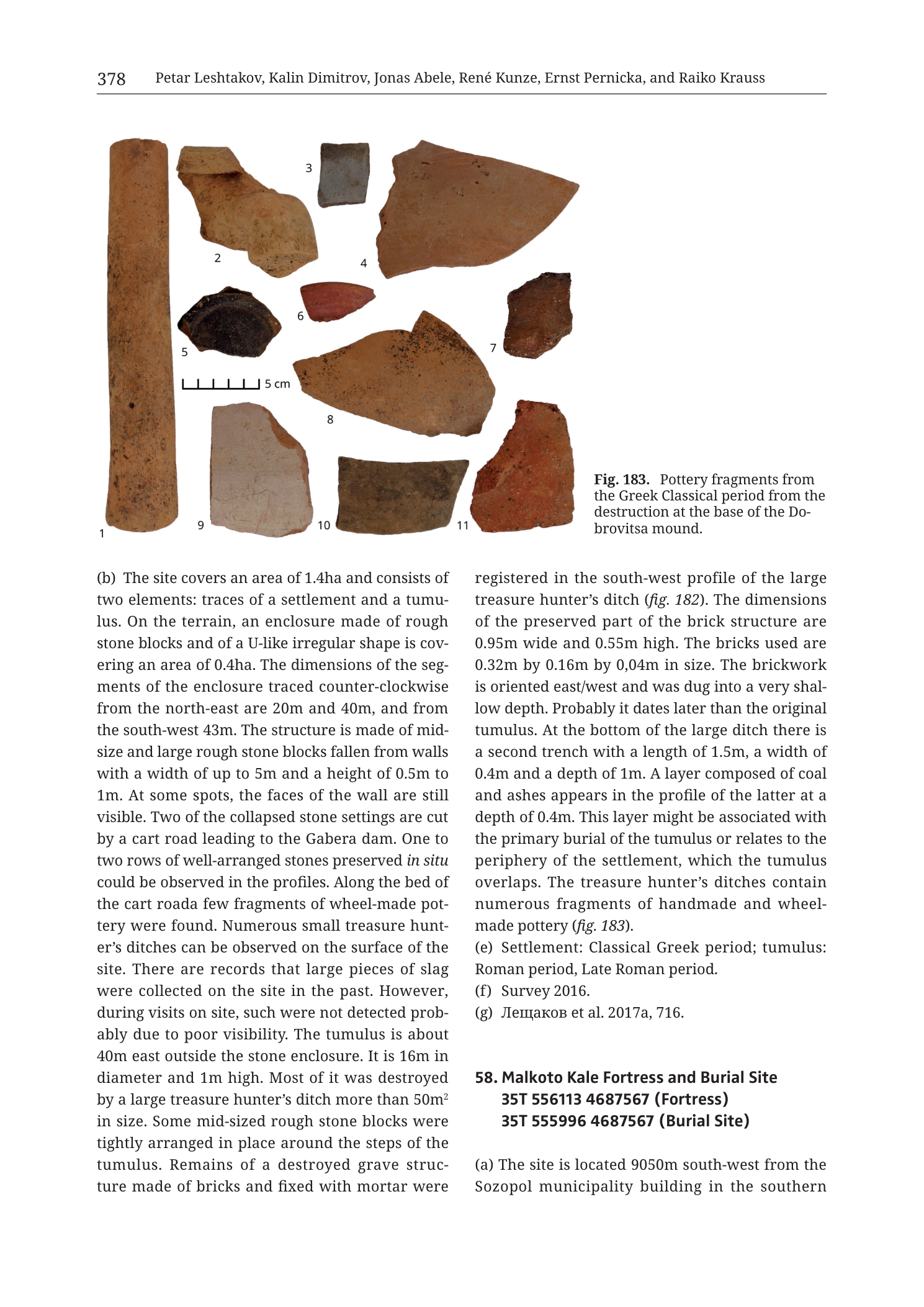
Caption (right of sherds): Fig. 183. Pottery fragments from the Greek Classical period from the destruction at the base of the Do- brovitsa mound.
Scale bar (left-centre among sherds, right of object 1 / below objects 2–5 area): bar with five divisions, labelled 5 cm.
Object numbers printed beside sherds:
- 1 — left of tall vertical cylindrical / tubular fragment (far left)
- 2 — left/above of large curved orange body/rim sherd (upper middle-left)
- 3 — above small dark grey rectangular chip (top centre)
- 4 — left of large fan-shaped / sector orange body sherd (upper right of main cluster)
- 5 — left of dark, near-black glossy curved sherd (mid-left)
- 6 — above small red flat chip (centre)
- 7 — right of irregular thick orange-brown fragment (mid-right)
- 8 — left of large curved orange body sherd with darker mottles (centre)
- 9 — below pale buff/pinkish flat rectangular fragment (lower left of cluster)
- 10 — below elongated brown-grey rectangular wall sherd (lower centre)
- 11 — below thick irregular red-orange fragment (lower right)
No other text on the photograph plate.
Body text — continuation of prior catalogue entry (Dobrovitsa / mound site; left → right columns above entry 58)
Left column:
(b) The site covers an area of 1.4ha and consists of two elements: traces of a settlement and a tumu- lus. On the terrain, an enclosure made of rough stone blocks and of a U-like irregular shape is cov- ering an area of 0.4ha. The dimensions of the seg- ments of the enclosure traced counter-clockwise from the north-east are 20m and 40m, and from the south-west 43m. The structure is made of mid- size and large rough stone blocks fallen from walls with a width of up to 5m and a height of 0.5m to 1m. At some spots, the faces of the wall are still visible. Two of the collapsed stone settings are cut by a cart road leading to the Gabera dam. One to two rows of well-arranged stones preserved in situ could be observed in the profiles. Along the bed of the cart road a few fragments of wheel-made pot- tery were found. Numerous small treasure hunt- er’s ditches can be observed on the surface of the site. There are records that large pieces of slag were collected on the site in the past. However, during visits on site, such were not detected prob- ably due to poor visibility. The tumulus is about 40m east outside the stone enclosure. It is 16m in diameter and 1m high. Most of it was destroyed by a large treasure hunter’s ditch more than 50m² in size. Some mid-sized rough stone blocks were tightly arranged in place around the steps of the tumulus. Remains of a destroyed grave struc- ture made of bricks and fixed with mortar were
Right column (continuation of same entry):
registered in the south-west profile of the large treasure hunter’s ditch (fig. 182). The dimensions of the preserved part of the brick structure are 0.95m wide and 0.55m high. The bricks used are 0.32m by 0.16m by 0,04m in size. The brickwork is oriented east/west and was dug into a very shal- low depth. Probably it dates later than the original tumulus. At the bottom of the large ditch there is a second trench with a length of 1.5m, a width of 0.4m and a depth of 1m. A layer composed of coal and ashes appears in the profile of the latter at a depth of 0.4m. This layer might be associated with the primary burial of the tumulus or relates to the periphery of the settlement, which the tumulus overlaps. The treasure hunter’s ditches contain numerous fragments of handmade and wheel- made pottery (fig. 183). (e) Settlement: Classical Greek period; tumulus: Roman period, Late Roman period. (f) Survey 2016. (g) Лещаков et al. 2017a, 716.
Translation (bibliographic author): Leshtakov et al. 2017a, 716.
Catalogue entry 58 (right column, lower — incomplete on this page)
- Malkoto Kale Fortress and Burial Site 35T 556113 4687567 (Fortress) 35T 555996 4687567 (Burial Site)
(a) The site is located 9050m south-west from the Sozopol municipality building in the southern
[text cuts off at bottom of page — remainder of entry 58 is on the following page(s), not in this PNG]
No map, no coordinate grid figure, and no LiDAR panel appear on this page image. Fig. 182 is referenced in text but not shown on this PNG.
Description
OVERVIEW / PAGE LAYOUT
Catalogue page from Krauss et al. (2020), Tübingen monograph. Printed page 378. Author running head: Petar Leshtakov, Kalin Dimitrov, Jonas Abele, René Kunze, Ernst Pernicka, and Raiko Krauss.
Layout:
- Top: single multi-object artefact plate — Fig. 183 (Classical Greek pottery from Dobrovitsa mound destruction).
- Below: two-column prose —
- Completion of the previous catalogue entry (a settlement + tumulus site with stone enclosure, Gabera-dam cart road, slag reports, brick grave structure; closed by fields (e)–(g)). Fig. 183 belongs to this prior entry, not to entry 58.
- Start of entry 58. Malkoto Kale Fortress and Burial Site with two UTM centroids; only the beginning of paragraph (a) is on this page.
Filename encodes Cat_p380_n58 (Malkoto Kale); the in-image page is 378. Visually, the dominant figure on the PNG is the Dobrovitsa pottery plate; Malkoto Kale is introduced only as text header + partial location sentence. No fortress plan, map, or photo of Malkoto Kale itself appears on this page.
Fig. 183 — Pottery fragments (Greek Classical period, Dobrovitsa mound)
Type & purpose. Studio artefact photograph of eleven numbered pottery fragments assigned by caption to the Greek Classical period, recovered from the destruction at the base of the Dobrovitsa mound. Illustrates the ceramic evidence cited in the preceding entry’s paragraph (b) (“numerous fragments of handmade and wheel-made pottery (fig. 183)” — caption here specifies Classical Greek for this selection).
Layout & scale.
- Objects scattered on a plain white background, roughly filling the upper half of the page width.
- Scale bar among the left-central sherds: 5 cm, five labelled divisions.
- Numbers 1–11 printed in black beside each piece.
Individual objects (observed form / fabric):
- Tall vertical tubular / cylindrical fragment, orange-brown fabric, elongated (height on the order of ~15–18 cm vs 5 cm bar — the longest piece). Circular cross-section; resembles a thick handle stub, stand, pipe segment, or heavy closed-form wall strip standing on end. Matt earthenware surface with darker mottles/staining toward the lower end.
- Large curved body/rim sherd, soft orange fabric, broad sector shape — open vessel wall (bowl/krater/jar). Thickness moderate; exterior slightly lighter than break.
- Small dark grey to blue-grey rectangular chip, fine fabric, contrasting sharply with the orange majority — possible reduced-fired fineware or different clay group.
- Large fan-shaped / annular-sector body sherd, even orange-brown, thin–moderate wall, gentle curvature — large open vessel.
- Dark, near-black curved sherd with residual slight sheen on the interior/upper face — appearance consistent with black-glazed or dark-slipped fineware (Classical Greek tableware signal), broken as a shallow bowl/cup fragment. Sits left-centre near the scale bar.
- Small flat red chip, oxidised, featureless at this resolution — body scrap.
- Irregular thick orange-brown fragment, angular breaks, coarser than 5 — utilitarian wall or near-base piece.
- Large curved orange body sherd with darker central mottling/staining, broad open-vessel curvature — one of the largest sherds after 1 and 4.
- Pale buff to pinkish flat rectangular fragment, softer lighter fabric than the deep orange pieces — possible different batch, slip remnant, or abraded surface.
- Elongated rectangular brown-grey wall sherd, flatter curvature, dull fabric — utilitarian.
- Thick irregular red-orange fragment, blocky, possibly near base or heavy wall; oxidised throughout.
Fabric / assemblage summary.
- Dominant fabric: oxidised orange to red-brown earthenware (utilitarian / common wares).
- Clear fineware outliers: item 5 (dark slipped/glazed) and item 3 (dark grey fine chip), supporting a Classical Greek date for at least part of the destruction assemblage.
- Mix of open-vessel body sherds (2, 4, 8) and thicker/technical or closed pieces (1, 7, 11).
- No painted figured decoration, stamps, graffiti, or dipinti are legible at page-render resolution.
- No separate fabric legend; chronological assignment is by caption only.
Relationship. Fig. 183 documents pottery from Dobrovitsa mound destruction contexts (prior entry), cross-referenced from the treasure-hunter ditch discussion and from fig. 182 (brick structure in ditch profile — not on this page).
Preceding catalogue entry (Dobrovitsa settlement + tumulus) — full text on page
The lettered paragraph on this page begins mid-entry at (b); header, centroid, and (a) were on the previous page (not in this PNG). Content reconstructible from the text:
(b) Site description.
- Area 1.4 ha; two elements: settlement traces + tumulus.
- Stone enclosure: rough stone blocks; U-like irregular plan; area 0.4 ha. Segment lengths counter-clockwise from NE: 20 m and 40 m; from SW: 43 m. Mid-size and large rough blocks fallen from walls; wall width up to 5 m, height 0.5–1 m. Wall faces still visible at spots. Two collapsed stone settings cut by a cart road to the Gabera dam. One–two rows of well-arranged stones preserved in situ in profiles. Wheel-made pottery fragments along the cart-road bed. Numerous small treasure-hunter ditches on the surface. Historical records of large slag pieces collected in the past; not detected on visits (poor visibility).
- Tumulus: ~40 m east outside the stone enclosure; 16 m diameter, 1 m high. Mostly destroyed by a large treasure-hunter ditch >50 m². Mid-sized rough stone blocks tightly arranged around tumulus steps. Destroyed brick-and-mortar grave structure registered in the SW profile of the large ditch (fig. 182): preserved part 0.95 m wide × 0.55 m high; bricks 0.32 × 0.16 × 0.04 m; brickwork oriented E–W, very shallow; probably later than the original tumulus. At ditch bottom, a second trench 1.5 m long × 0.4 m wide × 1 m deep; coal and ash layer at 0.4 m depth in that trench profile — possibly primary burial or settlement-periphery related (tumulus overlaps settlement periphery). Treasure-hunter ditches yielded numerous handmade and wheel-made pottery fragments (fig. 183).
(e) Date. Settlement: Classical Greek period; tumulus: Roman period, Late Roman period.
(f) Survey 2016.
(g) Лещаков et al. 2017a, 716.
Slag note. Past slag finds imply possible metallurgical activity at the settlement component even though slag was not re-located in 2016 visits — relevant to the broader Medni Rid archaeometallurgy theme of the monograph, though this page does not develop that further.
Entry 58 — Malkoto Kale Fortress and Burial Site (partial — start only)
Header. 58. Malkoto Kale Fortress and Burial Site
Centroids (both printed):
- Fortress: 35T 556113 4687567
- Burial Site: 35T 555996 4687567
Plan separation from the two printed coordinates:
- ΔEasting = 556113 − 555996 = 117 m (fortress is east of burial site)
- ΔNorthing = 0 (identical northing 4687567)
- Horizontal separation = 117 m due east–west.
(a) Location (incomplete). “The site is located 9050m south-west from the Sozopol municipality building in the southern…” — sentence and all remaining fields (b)–(g), figures, and architectural detail are not on this PNG.
No map/photo of Malkoto Kale on this page. The filename highlights n58, but visually this page is primarily the end of the Dobrovitsa entry + Fig. 183 + the bare opening of entry 58. Fortress architecture, walls, LiDAR, and pottery of Malkoto Kale itself must be sought on adjacent catalogue pages (not in this file).
Consistency Check
- Fig. 183 has no coordinate map — centroid check N/A for the pottery plate.
- Entry 58 centroids are printed in body text but no map with axis labels appears on this page, so map-bounds bracketing cannot be performed here.
- Regional sanity for entry 58 coordinates: Eastings 555996 / 556113 and Northing 4687567 fall in valid UTM 35T SE Bulgaria ranges (slightly east and south of Lobodovo Kale ~5536xx / 46891xx on the prior plate). PASS as regional values; full map check deferred to any later Malkoto Kale map figure not in this PNG.
- Dobrovitsa prior-entry centroid is not printed on this page.
RELATIONSHIP TO OTHER FIGURES / SITES
- Fig. 183 ↔ prior entry (Dobrovitsa mound destruction / Classical Greek pottery); also cites fig. 182 (brick grave in ditch profile — off-page).
- Entry 58 Malkoto Kale is only introduced; companion figures for the fortress/burial site are not on this page.
- Geographic anchors named in text: Gabera dam (cart road), Sozopol municipality building (entry 58 reference point, 9050 m NE of the site if site is 9050 m SW of the building).
- Filename’s “Malkoto_Kale_fortress” labels the page by the newly starting entry 58, not by the dominant Fig. 183 content.
Notes
- Printed page 378 vs filename p380 — book vs PDF pagination offset; in-image authority is 378.
- Fig. 183 is Dobrovitsa, not Malkoto Kale. Readers using only the filename may mis-attribute the pottery plate; the caption explicitly says Dobrovitsa mound.
- Entry 58 is severely truncated on this PNG (header + two centroids + first partial sentence of (a) only). No fortress description, dating, or bibliography for Malkoto Kale here.
- Brick dimensions use a decimal comma in one value as printed: “0,04m” (European notation) = 0.04 m thickness; other brick dimensions use dots (0.32m, 0.16m).
- “in situ” is italicised in the source text as printed.
- Past slag at the prior site is reported second-hand (“records… in the past”) and was not verified on 2016 visits — treated as historical report, not confirmed find in-text.
- No north arrow, coordinate grid, or scale applicable beyond the 5 cm artefact bar.
- None further.