Description
Transcription
Page header (top):
- Left: 374
- Centre/right: Petar Leshtakov, Kalin Dimitrov, Jonas Abele, René Kunze, Ernst Pernicka, and Raiko Krauss
Fig. 169 (upper left)
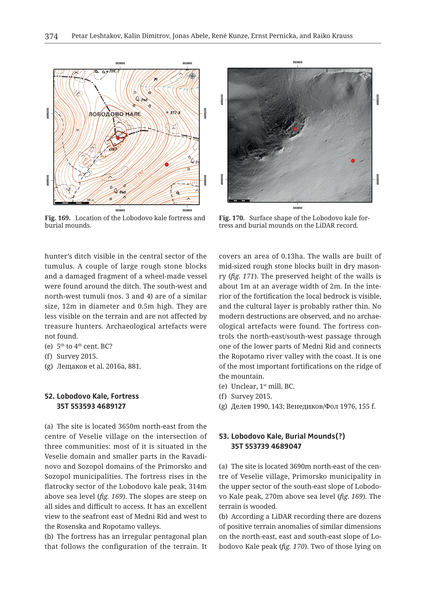
Caption: Fig. 169. Location of the Lobodovo kale fortress and burial mounds.
Coordinate grid — top (Easting, left → right):
- 553600
- 553800
Coordinate grid — bottom (Easting, left → right):
- 553600
- 553800
Coordinate grid — left edge (Northing, top → bottom):
- 4689200
- 4689000
Coordinate grid — right edge (Northing, top → bottom):
- 4689200
- 4689000
North arrow: compass rose in upper-right corner of map frame.
Scale bar (bottom-left inside map frame): labelled 100 m.
Place-name on map face (Cyrillic, across central high ground west of / over the fortress area):
- ЛОБОДОВО КАЛЕ Transliteration: Lobodovo Kale
Spot heights / contour-related numbers visible on map face:
- 296.3 (NW high, upper-left sector)
- 277.9 (NE sector)
- 280 (SE lower-right sector, near 4689000 line)
- Further contour labels in the mid-200 m range along brown contour lines (some digits small at render resolution)
Symbols on map face:
- Solid red filled circle near map centre — fortress location (on contoured rocky summit area)
- Second solid red filled circle SE of the first, lower on the SE slope — burial-mound / related locus marker
- Brown contour lines throughout (hill morphology)
- Dashed / pecked black lines (tracks or survey traverses) trending across slopes
- Small open triangles and open circles scattered on slopes (find/survey point markers, standard catalogue symbology)
- Dense brown contour packing around the central red marker indicating steep rocky summit
Fig. 170 (upper right)
Caption: Fig. 170. Surface shape of the Lobodovo kale for- tress and burial mounds on the LiDAR record.
Coordinate label — top centre (Easting):
- 553600
Coordinate labels — bottom:
- left end of axis area near scale
- 553600 (centre-bottom)
Coordinate grid — right edge (Northing, top → bottom):
- 4689200
- 4689000
(Left-edge northing ticks present at corresponding positions; values match the right edge.)
North arrow: compass rose in upper-right corner of image frame.
Scale bar (bottom-left inside frame): labelled 50 m.
Symbols:
- Solid red filled circle on a bright elevated irregular polyhedral platform near centre-left of frame — fortress
- Second solid red filled circle to the east / right of centre, on mid-slope — burial-mound locus
- Greyscale LiDAR hillshade / DSM surface (no contour numbers printed on this panel)
Body text — continuation of prior catalogue entry (above entry 52; left column upper text)
hunter’s ditch visible in the central sector of the tumulus. A couple of large rough stone blocks and a damaged fragment of a wheel-made vessel were found around the ditch. The south-west and north-west tumuli (nos. 3 and 4) are of a similar size, 12m in diameter and 0.5m high. They are less visible on the terrain and are not affected by treasure hunters. Archaeological artefacts were not found. (e) 5th to 4th cent. BC? (f) Survey 2015. (g) Лещаков et al. 2016a, 881.
Translation (bibliographic author name): Leshtakov et al. 2016a, 881.
Catalogue entry 52 (left column, continuing into right column)
- Lobodovo Kale, Fortress 35T 553593 4689127
(a) The site is located 3650m north-east from the centre of Veselie village on the intersection of three communities: most of it is situated in the Veselie domain and smaller parts in the Ravadi- novo and Sozopol domains of the Primorsko and Sozopol municipalities. The fortress rises in the flat rocky sector of the Lobodovo kale peak, 314m above sea level (fig. 169). The slopes are steep on all sides and difficult to access. It has an excellent view to the seafront east of Medni Rid and west to the Rosenska and Ropotamo valleys. (b) The fortress has an irregular pentagonal plan that follows the configuration of the terrain. It
[continues in right column:]
covers an area of 0.13ha. The walls are built of mid-sized rough stone blocks built in dry mason- ry (fig. 171). The preserved height of the walls is about 1m at an average width of 2m. In the inte- rior of the fortification the local bedrock is visible, and the cultural layer is probably rather thin. No modern destructions are observed, and no archae- ological artefacts were found. The fortress con- trols the north-east/south-west passage through one of the lower parts of Medni Rid and connects the Ropotamo river valley with the coast. It is one of the most important fortifications on the ridge of the mountain. (e) Unclear, 1st mill. BC. (f) Survey 2015. (g) Делев 1990, 143; Венедиков/Фол 1976, 155 f.
Translation (bibliographic refs): Delev 1990, 143; Venedikov/Fol 1976, 155 f.
Catalogue entry 53 (right column, lower)
- Lobodovo Kale, Burial Mounds(?) 35T 553739 4689047
(a) The site is located 3690m north-east of the cen- tre of Veselie village, Primorsko municipality in the upper sector of the south-east slope of Lobodo- vo Kale peak, 270m above sea level (fig. 169). The terrain is wooded. (b) According a LiDAR recording there are dozens of positive terrain anomalies of similar dimensions on the north-east, east and south-east slope of Lo- bodovo Kale peak (fig. 170). Two of those lying on
[text cuts off at bottom of page — continuation on following page not in this PNG]
No separate figure legend key beyond captions. Fig. 171 is referenced in text but is not on this page image.
Description
OVERVIEW / PAGE LAYOUT
Catalogue page from Krauss et al. (2020), Tübingen monograph. Printed page 374. Author running head lists Petar Leshtakov, Kalin Dimitrov, Jonas Abele, René Kunze, Ernst Pernicka, and Raiko Krauss.
Layout top-to-bottom:
- Two map figures side-by-side at top:
- Fig. 169 (left): topographic contour location map
- Fig. 170 (right): LiDAR hillshade / surface-shape image
- Two-column body text below:
- End of a preceding tumulus/burial entry (left column top)
- Full start of entry 52. Lobodovo Kale, Fortress (left → right columns)
- Start of entry 53. Lobodovo Kale, Burial Mounds(?) (right column lower; text incomplete at page break)
Filename encodes Cat_p376_n52; in-image page is 374. The page’s primary new sites are fortress (52) and burial mounds (53) at Lobodovo Kale on Medni Rid.
Fig. 169 — Topographic location map
Type & purpose. Contoured topographic map locating the Lobodovo Kale fortress and associated burial mound locus (two red markers) on the Lobodovo Kale peak massif. Provides metric plan position, local relief, and place-name context for catalogue entries 52–53.
Frame, extent, orientation.
- Rectangular map frame.
- North up; compass rose upper-right.
- Metric UTM-style grid (zone 35T implied by body-text centroids; zone label not printed on the panel itself).
Scale.
- Scale bar bottom-left: 100 m.
- No ratio scale printed.
- Labelled Easting span 553600→553800 = 200 m between labelled ticks; frame extends somewhat west of 553600 and east of 553800, so total E–W window is on the order of ~300–350 m.
- Labelled Northing span 4689000→4689200 = 200 m; frame extends slightly beyond both, total N–S window ~250–300 m.
Coordinates / grid.
- Easting labels top/bottom: 553600, 553800.
- Northing labels left/right: 4689200, 4689000.
- Faint interior grid cross at centre.
Relief & physiography.
- Brown contour lines depict a prominent rocky hill / peak. Contours form a tight concentric to slightly elongated nest around the central (fortress) red marker, indicating a steep-sided summit.
- Spot heights:
- 296.3 m — northwestern high ground
- 277.9 m — northeastern flank
- 280 m — southeastern lower area near the 4689000 grid line
- Crest zone around the fortress sits above the upper 280–290+ m contours; body text states fortress altitude 314 m a.s.l. (that exact spot height is not printed as “314” on the visible face at this render — the 314 m value is from catalogue text (a), while on-map spot heights show nearby highs 296.3 / 277.9).
- Contour packing is tightest immediately around the central red marker on all sides — “flat rocky sector” of a peak with steep drops, matching text description.
- SE red marker sits lower on more open SE slope contours, consistent with text elevation 270 m a.s.l. for the burial-mound site.
Hydrography.
- No blue stream lines obvious on this small summit window. Drainage is implied only by contour re-entrants.
Anthropogenic / cultural features.
- Central solid red circle — Lobodovo Kale fortress (entry 52). Sits on the contoured rocky summit under/near the Cyrillic label.
- SE solid red circle — burial mounds(?) locus (entry 53), downslope southeast of the fortress.
- Cyrillic place-name ЛОБОДОВО КАЛЕ (Lobodovo Kale) printed in spaced capitals across the central high ground.
- Small open triangles and open circles on surrounding slopes — survey/find markers (standard catalogue point symbology).
- Dashed black linear traces on slopes — likely tracks, paths, or survey lines.
- No building footprints, wall plans, or individual tumulus circles are drawn as architectural plans on this topo panel (fortress plan detail is left to text + LiDAR + the off-page fig. 171).
Geological content.
- No lithological units. Pure topographic/archaeological location map. Text notes local bedrock visible inside the fort (geological mapping not shown here).
Colour & symbol system.
- White ground; brown contours; black grid/labels; red site markers; black dashed lines and small point symbols.
Spatial relationships (Fig. 169).
- Fortress occupies the summit rocky platform of Lobodovo Kale peak; burial-mound marker lies ~100–150+ m southeast and downslope (visual vs 100 m bar and grid).
- Steep contour rings isolate the fortress on all sides — controlling a local high on Medni Rid.
- Two red markers correspond 1:1 to catalogue centroids 52 and 53 (see Consistency Check).
Consistency Check (Fig. 169)
Entry 52 — Fortress
- Centroid (body text): 35T 553593 4689127
- Map bounds (labelled ticks): Easting [553600–553800] labelled, with frame extending west of 553600; Northing [4689000–4689200] labelled, frame extending slightly beyond.
- Centroid Easting 553593 is just west of the 553600 label — still inside the drawn frame (frame margin west of 553600 is visible). Centroid Northing 4689127 lies between 4689000 and 4689200.
- Central red marker position matches this centroid (summit, slightly west of map centre-line near 553600).
- Result: PASS (Easting at the western label edge is expected; marker is inside the frame).
Entry 53 — Burial Mounds(?)
- Centroid (body text): 35T 553739 4689047
- Easting 553739 ∈ (553600, 553800); Northing 4689047 ∈ (4689000, 4689200).
- SE red marker sits SE of fortress at lower elevation — matches.
- Result: PASS.
Regional sanity: eastings ~5536–5538xx and northings ~4689xxx are valid UTM 35T values for the Medni Rid / Primorsko–Sozopol hinterland (slightly east/south of the Aivadzhik ~545k E / 4693k N window of other plates).
Fig. 170 — LiDAR surface shape
Type & purpose. Greyscale LiDAR-derived hillshade / DSM of the same Lobodovo Kale summit and SE slope, showing micro-relief of the fortress platform and positive terrain anomalies interpreted as burial mounds. Companion to Fig. 169 and to text paragraphs (b) of entries 52–53.
Frame, extent, orientation.
- Rectangular frame, north up, compass rose upper-right.
- Easting reference 553600 at top-centre and bottom-centre.
- Northing labels 4689200 (top) and 4689000 (bottom) on the right edge.
- Window is a tighter zoom than Fig. 169’s full contour map context: scale bar is 50 m (half of Fig. 169’s 100 m), so ground coverage is smaller — on the order of ~200–250 m across.
Scale.
- Scale bar bottom-left: 50 m.
- No ratio scale.
Relief rendering (LiDAR).
- Continuous greyscale hillshade: illumination from upper-left (NW) casting soft shadows SE-ward.
- Bright raised irregular polyhedral / sub-pentagonal platform near centre-left — the fortress interior and wall line as a positive topographic body on the rocky crest. Edges drop steeply; surrounding slopes fall away, especially SE and NE.
- SE and E slopes show multiple small positive bumps / mound-like anomalies of similar size — the “dozens of positive terrain anomalies” cited in entry 53(b). Vegetation canopy is suppressed or bare-earth-filtered enough that ground shape reads through; some residual roughness may include trees/low scrub.
- No printed contours or spot heights on the LiDAR panel.
Anthropogenic / cultural features visible in relief.
- Fortress (western red dot): sits on the bright elevated platform. Plan reads as an irregular, roughly pentagonal / faceted enclosure following the rock outcrop — agrees with text “irregular pentagonal plan that follows the configuration of the terrain” and area 0.13 ha. Wall banks appear as linear breaks-in-slope around the platform perimeter rather than freestanding masonry in the LiDAR greyscale.
- Burial-mound locus (eastern red dot): on mid SE slope among a field of smaller positive anomalies. Individual mound diameters are not dimensioned on the image; text of the incomplete entry 53 and the prior-entry spillover discuss tumuli of order ~12 m diameter in related contexts.
- No modern roads or large spoil heaps dominate the frame; text states no modern destructions observed at the fortress.
Spatial relationships (Fig. 170).
- Fortress platform is the highest local LiDAR high body; burial-mound scatter occupies the NE, E and SE slopes down from it (text), with the eastern red marker highlighting one focus of that scatter.
- Relative marker spacing agrees with Fig. 169 (~100+ m SE separation at 50 m scale).
- LiDAR confirms the fortress’s command of the crest and the approach slopes where mounds cluster.
Consistency Check (Fig. 170)
- Same two centroids as Fig. 169 must fall in frame.
- Fortress red dot near 553600 E / ~4689120 N region: PASS with 35T 553593 4689127.
- Eastern red dot lower-right of fortress aligns toward 35T 553739 4689047: PASS.
- Cross-panel agreement with Fig. 169: PASS.
Body text — preceding entry fragment (left column top)
Continuation (not the start) of a prior catalogue entry concerning tumuli / burial mounds (treasure-hunter’s ditch; tumuli nos. 3 and 4 at 12 m diameter, 0.5 m high; no artefacts). Dating (e) 5th to 4th cent. BC?; (f) Survey 2015; (g) Лещаков et al. 2016a, 881. This fragment belongs to the entry above 52 on the previous page logic; it is only partial here. Possibly related to the broader Lobodovo mound landscape but is not entry 52 itself.
Entry 52 — Lobodovo Kale, Fortress (full text on page)
Header. 52. Lobodovo Kale, Fortress
Centroid. 35T 553593 4689127
(a) Location. 3650 m NE of Veselie village centre, at the intersection of three community domains: mostly Veselie, smaller parts in Ravadinovo and Sozopol domains (Primorsko and Sozopol municipalities). Fortress on the flat rocky sector of Lobodovo kale peak, 314 m a.s.l. (fig. 169). Steep slopes all sides, difficult access. Excellent view east to the seafront east of Medni Rid, and west to the Rosenska and Ropotamo valleys.
(b) Description. Irregular pentagonal plan following terrain. Area 0.13 ha. Walls of mid-sized rough stone blocks in dry masonry (fig. 171 — not on this page). Preserved wall height ~1 m, average width ~2 m. Interior: local bedrock visible; cultural layer probably thin. No modern destructions; no archaeological artefacts found. Strategic role: controls the NE–SW passage through a lower part of Medni Rid connecting the Ropotamo river valley with the coast; one of the most important fortifications on the mountain ridge.
(e) Date. Unclear, 1st millennium BC.
(f) Investigation. Survey 2015.
(g) Bibliography. Делев 1990, 143; Венедиков/Фол 1976, 155 f.
(Fields (c)–(d) if used in the catalogue schema are not present as lettered paragraphs on this page for entry 52.)
Entry 53 — Lobodovo Kale, Burial Mounds(?) (partial)
Header. 53. Lobodovo Kale, Burial Mounds(?)
Centroid. 35T 553739 4689047
(Note the parenthetical (?) — identification as burial mounds is tentative in the catalogue.)
(a) Location. 3690 m NE of Veselie village centre, Primorsko municipality; upper sector of the SE slope of Lobodovo Kale peak, 270 m a.s.l. (fig. 169). Terrain wooded.
(b) Description (incomplete on this page). According to a LiDAR recording there are dozens of positive terrain anomalies of similar dimensions on the NE, E and SE slope of Lobodovo Kale peak (fig. 170). Text continues “Two of those lying on…” and cuts off at the page bottom — remainder is on the next monograph page (not in this PNG).
(e)–(g) for entry 53 are not reached on this page.
RELATIONSHIP TO OTHER FIGURES / SITES
- Fig. 169 ↔ Fig. 170: same two loci, topo vs LiDAR, different scales (100 m vs 50 m bars).
- Fig. 171 (wall masonry photo/detail) is cited in 52(b) but absent from this PNG.
- Geographic setting: Medni Rid ridge system; links Ropotamo valley ↔ Black Sea coastal side; near Veselie, Ravadinovo, Sozopol municipal territories.
- Fortress (52) and burial mounds (53) are paired Lobodovo Kale sites ~150 m apart in plan (centroid ΔE ≈ 146 m, ΔN ≈ 80 m; horizontal separation √(146²+80²) ≈ 166 m).
- Filename focus n52 = fortress entry; page also introduces n53 mounds.
Notes
- Printed page 374 vs filename p376 — book vs PDF pagination offset; in-image authority is 374.
- Fig. 171 referenced but not shown on this page.
- Entry 53 body text is truncated mid-sentence at page end; dating, survey, and bibliography for 53 are not on this PNG.
- On-map spot heights (296.3, 277.9, 280) do not include a printed “314” at the fortress dot; 314 m a.s.l. is from catalogue text (a) and may refer to the true peak elevation slightly off the labelled spots or from a different measurement. Flagged as text vs map-label mild discrepancy, not a grid error.
- Cyrillic map label ЛОБОДОВО КАЛЕ = Lobodovo Kale (also “Lobodovo kale” in captions, lowercase k).
- Prior-entry tumulus paragraph at top-left is not entry 52; do not merge its 5th–4th cent. BC? date into the fortress (fortress date is 1st mill. BC, unclear).
- LiDAR illumination direction inferred from shading; not stated in caption.
- “Burial Mounds(?)” uncertainty is the catalogue’s own.
- None further.