Description
Transcription
Page header (top centre): Catalogue of Investigated Archaeological Sites and Mining Places
Page number (top right): 367
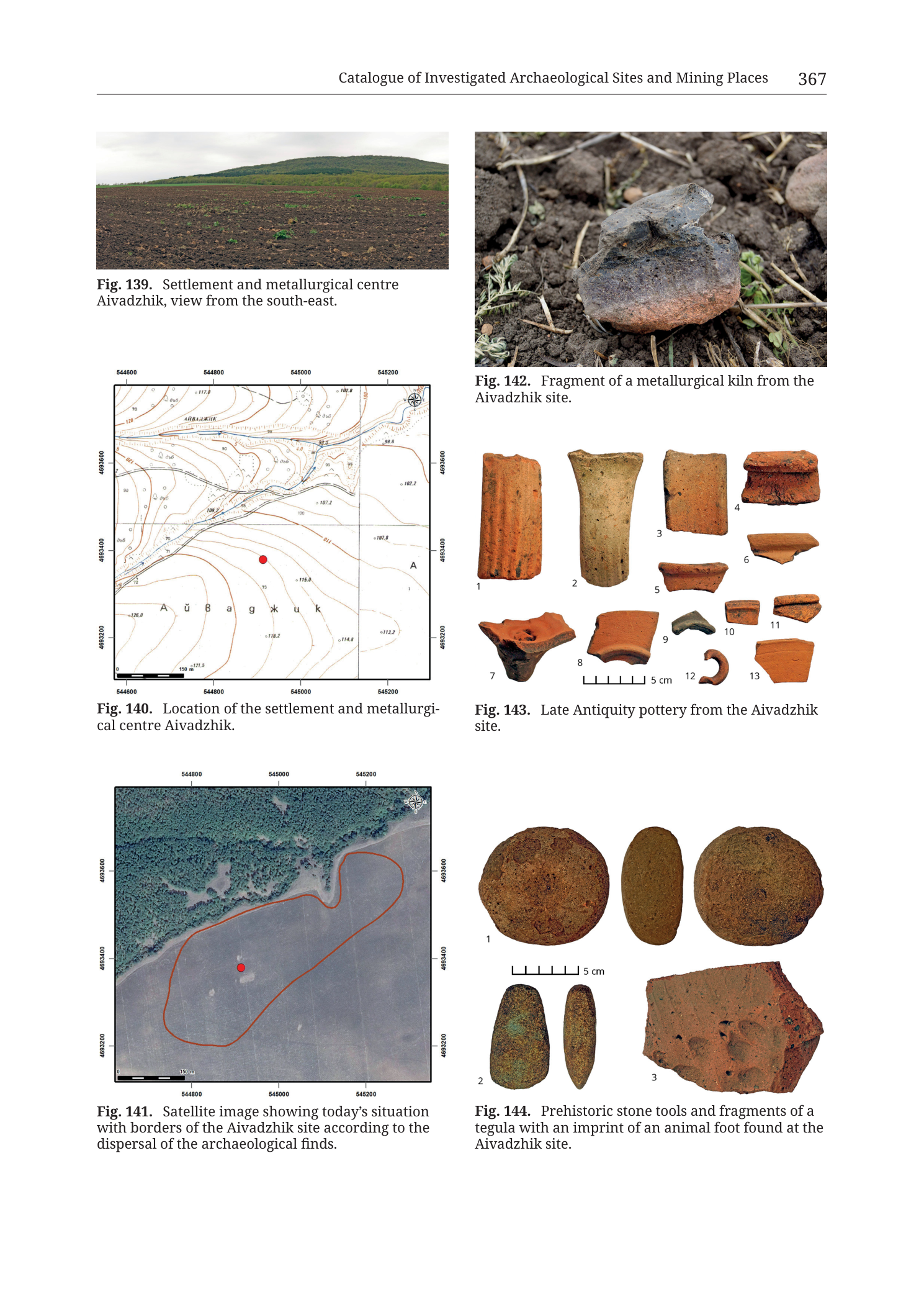
Fig. 139 (upper left)
Caption: Fig. 139. Settlement and metallurgical centre Aivadzhik, view from the south-east.
No other printed text on the photograph.
Fig. 140 (middle left)
Caption: Fig. 140. Location of the settlement and metallurgi- cal centre Aivadzhik.
Coordinate grid — top (Easting, left → right):
- 544600
- 544800
- 545000
- 545200
Coordinate grid — bottom (Easting, left → right):
- 544600
- 544800
- 545000
- 545200
Coordinate grid — left edge (Northing, top → bottom):
- 4693800
- 4693600
- 4693400
- 4693200
Coordinate grid — right edge (Northing, top → bottom):
- 4693800
- 4693600
- 4693400
- 4693200
North arrow: compass rose / north indicator in upper-right corner of map frame (arrow/N mark).
Scale bar (bottom-left inside map frame): labelled 150 m (bar with end ticks).
Contour / spot-height labels visible on map face (as printed; some partially small):
- 120 (upper-left contour area)
- ≈ 117.8 (upper-central spot height)
- 115 (several contour labels in NW/central area)
- 110 (contour labels)
- 105 (contour labels)
- 100 (contour labels near centre-right of hill)
- 95 (contour labels)
- 90 (contour labels)
- 85 (contour labels, lower flanks)
- 80 (contour labels, lower flanks)
- ≈ 102.2 (NE sector spot height)
- ≈ 107.2 (east-central spot height)
- ≈ 107.8 (east-central spot height slightly SE of previous)
- ≈ 115.0 (spot height SE of red site marker)
- ≈ 112.2 (SE sector spot height)
- ≈ 114.0 (SE sector spot height)
- ≈ 126.0 (SW sector spot height)
- ≈ 118.2 (south-central spot height near place-name)
- Further small spot heights in the 80–120 m range are printed along contours; a few digits are marginal at this render resolution and marked ≈ where not fully sharp.
Place-name label printed across the lower-central / southern flank of the hill mass, in mixed Latin–Cyrillic letterforms approximating the site name Aivadzhik (characters appear roughly as A ŭ / mixed forms + a g ж u/i k [partially stylised; transcribed as the intended toponym Aivadzhik matching the captions]).
Letter “A” printed once near the western mid-frame and once near the eastern mid-frame (map reference / sheet letters).
Blue linear feature (stream / drainage) traced roughly W–E to WNW–ESE across the northern third of the map, with short blue tributary ticks.
Open circles (find/locality markers) scattered mainly on the western and central slopes west and northwest of the red site marker; denser open-circle cluster on the west-central slope.
Solid red filled circle: site centroid / location marker near map centre, on the southern flank of the closed contour hill, slightly south of the 100–105 m contour belt.
Cross-hair grid intersections at the four interior crosses of the 200 m grid.
Fig. 141 (lower left)
Caption: Fig. 141. Satellite image showing today’s situation with borders of the Aivadzhik site according to the dispersal of the archaeological finds.
Coordinate grid — top (Easting, left → right):
- 544800
- 545000
- 545200
Coordinate grid — bottom (Easting, left → right):
- 544800
- 545000
- 545200
Coordinate grid — left edge (Northing, top → bottom):
- 4693600
- 4693400
- 4693200
Coordinate grid — right edge (Northing, top → bottom):
- 4693600
- 4693400
- 4693200
North arrow: compass rose / north indicator in upper-right corner of image frame.
Scale bar (bottom-left inside frame): labelled 150 m.
Solid red filled circle: site centroid near centre of frame.
Closed red polygon outline: elongated roughly E–W to ENE–WSW oval/lozenge enclosing the site area of find dispersal; centroid lies inside the western-central part of this outline.
No other printed place names on the satellite panel.
Fig. 142 (upper right)
Caption: Fig. 142. Fragment of a metallurgical kiln from the Aivadzhik site.
No scale bar, no other text on the photograph.
Fig. 143 (middle right)
Caption: Fig. 143. Late Antiquity pottery from the Aivadzhik site.
Object numbers printed beside each sherd (1–13):
- 1 — left of upper-left tall ribbed fragment
- 2 — below tall flaring tubular fragment
- 3 — right of rectangular flat fragment
- 4 — right of small boxy/corner fragment
- 5 — below small curved rim under 3
- 6 — right of small curved sherd under 4
- 7 — below irregular base/foot fragment (lower left)
- 8 — below curved body/rim sherd
- 9 — right of small dark rim sherd
- 10 — above small rectangular orange bit
- 11 — right of small elongated orange bit
- 12 — below small C-shaped ring fragment
- 13 — right of triangular body sherd (lower right)
Scale bar (centre-bottom of plate, under objects 8/12 area): bar with five divisions, labelled 5 cm.
Fig. 144 (lower right)
Caption: Fig. 144. Prehistoric stone tools and fragments of a tegula with an imprint of an animal foot found at the Aivadzhik site.
Object numbers:
- 1 — left of large circular stone disc (upper left)
- 2 — left of pair of elongated stone tool views (lower left; face + profile)
- 3 — left/below of tegula fragment with paw imprint (lower right)
Scale bar (under object 1 / between 1 and 2–3): bar with five divisions, labelled 5 cm.
No body-text catalogue paragraph with a printed “35T … …” centroid appears on this page image (entry text is on preceding catalogue pages, not in this PNG).
Description
OVERVIEW / PAGE LAYOUT
Full catalogue plate page from Krauss et al. (2020), Tübingen monograph, chapter “Catalogue of Investigated Archaeological Sites and Mining Places”. Printed page number 367. The plate documents site Aivadzhik (settlement and metallurgical centre) as a six-figure multi-panel layout:
| Position | Figure | Content type |
|---|---|---|
| Upper left | Fig. 139 | Landscape photograph |
| Middle left | Fig. 140 | Topographic contour location map |
| Lower left | Fig. 141 | Satellite image with site boundary |
| Upper right | Fig. 142 | Artefact photograph (kiln fragment) |
| Middle right | Fig. 143 | Artefact plate (Late Antiquity pottery, n=13) |
| Lower right | Fig. 144 | Artefact plate (prehistoric stone tools + tegula, n=3 groups) |
Left column = landscape context + cartographic location; right column = portable finds (kiln, pottery, stone/tegula). Filename encodes Cat_p369_n42 (catalogue entry ~42) while the rendered header shows page 367 — page offset relative to PDF pagination is a known monograph trait; the in-image page number is 367.
Fig. 139 — Landscape photograph
Type & purpose. Colour field photograph presenting the modern surface setting of the Aivadzhik settlement and metallurgical centre, viewed from the south-east looking toward the site’s hill/ridge backdrop.
Composition.
- Foreground / mid-ground: Broad, recently ploughed agricultural field. Soil is dark brown to near-black, broken into coarse clods typical of autumn/spring tillage. Sparse small green weed/volunteer plants are scattered across the tilled surface; no standing crop.
- Background: A long, gentle to moderately rising forested hill or ridge filling the horizon, densely clothed in mixed green woodland (leaf-on condition — late spring to summer foliage). The ridge crest is smoothly convex, higher toward the left-centre of the frame and descending slightly toward the right. No buildings, roads, or mine infrastructure are visible on the skyline.
- Sky: Overcast / pale grey-white cloud cover, diffuse lighting, low contrast shadows.
Orientation / view. Caption states view from the south-east — camera looking roughly northwestward toward the hill that hosts or backs the site. No people, vehicles, scale rods, or north markers in frame. No geological outcrop detail is resolved at this distance; the image’s role is topographic/landscape context for Figs. 140–141.
Anthropogenic features. Intensive modern ploughing of the near field — consistent with a surface-find assemblage recovered from cultivated land (as implied by Fig. 141’s find-dispersal boundary over open ground).
Fig. 140 — Topographic location map
Type & purpose. Contoured topographic site-location map fixing the Aivadzhik settlement/metallurgical centre (red dot) on a metric grid with elevation, drainage, and surface-find markers. Intended to give metric plan position and local relief for the catalogue entry.
Frame, extent, orientation.
- Rectangular map frame, portrait-ish panel within the page column.
- North up; north indicator in the upper-right corner of the frame.
- Coordinate system: metric grid with six-digit Eastings and seven-digit Northings — standard UTM-style metre grid used throughout the Krauss et al. catalogue (zone 35T context for SE Bulgaria; zone label itself is not printed on this panel).
Scale.
- Graphical scale bar bottom-left: 150 m.
- No ratio scale (e.g. 1:5 000) printed.
- Frame ground distance: Easting span 544600→545200 = 600 m; Northing span 4693200→4693800 = 600 m. The map window is therefore a ~600 × 600 m square.
Coordinates / grid.
- Easting ticks/labels: 544600, 544800, 545000, 545200 (200 m spacing).
- Northing ticks/labels: 4693800, 4693600, 4693400, 4693200 (200 m spacing).
- Interior cross-hair intersections mark the 200 m grid nodes.
- Light grey grid lines divide the frame into 200 m cells (3 cells E–W × 3 cells N–S).
Relief & physiography.
- Relief rendered by brown contour lines with numeric elevation labels in metres.
- Contour pattern: a clear closed hill / knoll occupies the centre of the map, with roughly concentric contours. The hill crest/high ground lies slightly north of the red site marker; contours open and descend toward the south and especially toward the east and northeast into lower ground.
- Approximate elevation range on-panel: from the low ~80 m contours on the lower flanks up to crest-area values around ~120 m (spot ~117.8 m near the upper central high; SW spot ~126.0 m on a local high). Spot heights in the 100–115 m band cluster on the mid-slopes around and east of the site marker (≈102.2, 107.2, 107.8, 112.2, 114.0, 115.0, 118.2).
- Contour interval: appears to be 5 m (labels at 80, 85, 90, 95, 100, 105, 110, 115, 120), consistent with other catalogue topo panels in this volume.
- Slope character: moderately spaced contours on the upper hill (gentler crest), tighter packing on parts of the flanks indicating steeper local slopes; overall a compact hill rising ~30–40 m above the surrounding ~80–90 m ground within the 600 m window.
Hydrography.
- A blue line traces a watercourse / drainage roughly across the northern third of the map, flowing in a general west–east to WNW–ESE sense north of the main hill crest, with small blue ticks suggesting minor tributary joins. No river name is printed.
Anthropogenic / cultural / find symbols.
- Solid red circle: primary site location marker (settlement and metallurgical centre centroid) near geometric centre of the frame, on the southern flank of the contoured hill (south of the crest contours, north of the place-name lettering).
- Open circles: multiple small open-circle symbols scattered mainly on the western and west-central slopes of the hill and some on adjacent ground — these are the catalogue’s usual markers for individual surface finds / surveyed points (not a separate legend on this crop, but standard for the series). Density is higher west of the red centroid than east of it.
- Place-name Aivadzhik (mixed-script letterforms) printed across the southern lower flank of the hill, south of the red marker.
- Letters “A” at west and east mid-frame — sheet/map reference letters, not site labels.
- No roads, buildings, fortress walls, adits, spoil heaps, or kiln footprints are drawn as plan symbols on this topo panel.
Geological content.
- None as lithological mapping. This is a pure topographic/archaeological location map — no rock-unit colours, no faults, no ore-vein traces, no stratigraphic legend.
Colour & symbol system.
- White/pale ground; brown contours; blue hydrography; black grid and labels; red site marker; open black/grey find circles.
- No hypsometric tint or hillshade.
Spatial relationships.
- The Aivadzhik site marker sits on the south slope of a small hill whose crest rises to ~115–120 m immediately north of the red dot, within a 600 × 600 m window centred near Easting ~544900, Northing ~4693400.
- Surface-find open circles concentrate on the western hillside, suggesting the scatter extends upslope and westward from the formal centroid, not only at the red point.
- Drainage passes north of the hill, separating the site hill from still higher or separate ground further north (upper frame shows additional contour noses).
- Relative to the SE Bulgaria Medni Rid / Rosen ore-field geography: the easting (~544–545k) and northing (~4693k) place the site in the broader Burgas–Medni Rid coastal hinterland UTM 35T band used throughout this catalogue (exact relation to named mines is not annotated on this panel).
Relationship to other figures.
- Companion to Fig. 141 (same site, satellite + find-dispersal border, slightly different window).
- Landscape context in Fig. 139 (SE view toward the hill).
- Finds from the site in Figs. 142–144 (kiln fragment, Late Antiquity pottery, prehistoric tools + tegula).
Consistency Check (Fig. 140)
- Centroid (body text “35T … …”): not printed on this page image — catalogue prose with the formal 35T centroid lies on preceding entry text pages, not in this figure plate.
- Map bounds (Fig. 140): Easting [544600–545200], Northing [4693200–4693800].
- Red marker visual position: approximately Easting ~544900–544950, Northing ~4693380–4693420 (inside bounds).
- Result: PASS for internal consistency of the red marker within the labelled grid. Full body-text centroid bracketing cannot be completed from this PNG alone.
- Valid SE Bulgaria 35T sanity: easting ~545k and northing ~4693k fall inside the expected regional ranges (~530000–560000 E, ~4600000–4700000 N).
Fig. 141 — Satellite image with site border
Type & purpose. Orthorectified (or near-ortho) true-colour satellite / aerial image of the same locality, overprinted with the archaeological site border defined by dispersal of finds, plus the red centroid. Purpose: show modern land cover and the plan-shape/extent of the find scatter versus the single-point marker of Fig. 140.
Frame, extent, orientation.
- Rectangular frame, north up, north indicator upper-right.
- Easting labels: 544800, 545000, 545200 (200 m); the western map edge sits slightly west of 544800 (approximately mid-way toward a not-printed 544600), so the window is roughly ~500–600 m E–W.
- Northing labels: 4693600, 4693400, 4693200 (200 m); frame extends slightly north of 4693600 and slightly south of 4693200 — about ~500–550 m N–S.
- Overlaps the central/southern portion of Fig. 140’s 600 m window; northern drainage strip of Fig. 140 is partly cropped.
Scale.
- Scale bar bottom-left: 150 m (same as Fig. 140).
- No ratio scale printed.
Land cover / physiography (from imagery).
- Northern half: dense dark-green forest / woodland canopy, corresponding to the wooded hill of Fig. 139 and the contoured high ground of Fig. 140.
- Central and southern half: open agricultural field — grey-brown bare or sparsely vegetated cultivated ground, matching the ploughed foreground of Fig. 139.
- Forest–field boundary runs roughly E–W to ENE–WSW across the upper-central part of the frame; the red site outline straddles this ecotone (northern lobe into trees, southern bulk on open field).
- No buildings, roads of major width, or industrial plant are obvious inside the red outline at this resolution; faint linear traces (tracks/field edges) may exist but are not labelled.
Anthropogenic / site symbols.
- Solid red circle: site centroid, same role as Fig. 140, located in the open field just south of the forest edge, slightly west of frame centre.
- Closed red polygon: elongated E–W to ENE–WSW oval/lozenge enclosing the area of archaeological-find dispersal. Approximate dimensions against the 150 m bar and 200 m grid: on the order of ~350–450 m long (E–W) by ~150–200 m wide (N–S) (visual estimate only). The polygon’s western and eastern ends are rounded; the northern edge bites into the forest; the southern edge lies well out in the open field.
- Centroid sits inside the polygon, somewhat west of the polygon’s geometric centre and closer to the forest margin than to the southern field edge of the outline.
Spatial relationships.
- Confirms Fig. 140’s placement: site on the lower southern flank of a wooded hill, with the main find halo covering ploughed land at the forest edge — explaining surface recovery of pottery, kiln fragments, and stone tools (Figs. 142–144).
- The find-dispersal border is far larger than a single structure footprint; it denotes a settlement/activity scatter (and metallurgical centre) rather than a pinpoint kiln only.
- Forest cover on the hill may conceal further unploughed archaeological ground north of the centroid.
Consistency Check (Fig. 141)
- Map bounds (labelled): Easting [≈544700–545200], Northing [≈4693150–4693650] (labels at 544800–545200 E, 4693200–4693600 N; frame slightly exceeds outer labels).
- Red centroid and entire red polygon lie inside the labelled grid range.
- Red centroid position agrees with Fig. 140’s marker (~5449xx E, ~46934xx N).
- Result: PASS (internal + cross-panel agreement with Fig. 140). Body-text 35T centroid still not on this page.
Fig. 142 — Metallurgical kiln fragment
Type & purpose. Close-up colour photograph of a single fragment of a metallurgical kiln recovered from the Aivadzhik site — primary evidence for on-site pyrotechnical / metallurgical activity that justifies the catalogue designation “settlement and metallurgical centre”.
What is shown.
- Irregular, roughly fist-to-two-fist-sized lump of kiln wall / lining material resting on dark tilled soil among small green plants and dry grass stems (field-find context, not a museum lightbox).
- Fabric: dense, heat-affected ceramic/earthy material. Upper/outer surfaces show dark grey to blue-grey, almost slaggy or heavily reduced coloration; broken edges and underside grades to reddish-brown / terracotta oxidised ceramic — classic kiln-lining colour zonation from hot face to cooler exterior.
- Surface texture: rough, pitted, partially vitrified or slag-adhered patches on the dark face; no complete tuyère bore or full chamber curvature is preserved in this fragment alone, but the piece is thick-walled and massy rather than a thin pot sherd.
- No scale bar, no north arrow, no inventory number printed on the photo (identification is by caption only).
- Lighting: natural daylight, slightly cool; shallow depth of field with background soil soft.
Archaeometallurgical reading (observed). The dual grey-reduced / red-oxidised fabric and mass support identification as kiln structural ceramic (furnace wall or lining fragment), not ordinary domestic pottery. Together with the site label “metallurgical centre”, this is the key industrial find on the plate; process metal (copper vs iron etc.) is not determinable from this image alone.
Fig. 143 — Late Antiquity pottery (13 pieces)
Type & purpose. Studio-style artefact plate of Late Antiquity pottery from Aivadzhik, numbered 1–13, with a 5 cm scale — documenting the ceramic chronological signal of the settlement occupation.
Layout. Objects arranged on a plain white background in roughly two registers (upper row 1–6 area; lower row 7–13), not in a strict grid. Scale bar centred low: 5 cm with millimetre-style subdivision ticks (five major divisions).
Individual objects (observed form / fabric):
- Tall vertical fragment, orange-red fabric, exterior with strong vertical ribbing / fluting (corrugated or reeded wall). Appears to be a thick wall section of a large vessel, pipe, or technical ceramic; roughly rectangular outline, broken top and bottom. Height on the order of ~8–10 cm against the 5 cm bar (visual).
- Tall flaring tubular / conical piece, orange grading to pale buff toward the wider end; exterior vertical fluting/ribbing. Wider mouth-like end at top, tapering downward — possibly a neck, stand, or kiln/technical ceramic element rather than a simple bowl rim. Tallest object on the plate (~10–12 cm visual).
- Rectangular flat slab, even orange-red fabric, roughly brick/tile-like with straight broken edges — body sherd of a thick-walled vessel or tile.
- Small boxy / corner fragment, orange-red, with a right-angle return — corner of a tile, box flue, or angular vessel.
- Curved rim or carination sherd, orange, low profile under item 3.
- Small curved wall sherd, orange, to the right of 4/5.
- Irregular base / foot or heavily broken thick fragment, orange-red with darker core patches; chunky, not a fine tableware foot — lower left of plate.
- Curved body/rim sherd, orange, open arc — bowl or jar wall.
- Small dark grey-brown rim sherd, reduced or differently fired fabric, contrasting with the dominant orange series — indicates fabric diversity in the assemblage.
- Tiny rectangular orange chip, upper right of lower cluster.
- Small elongated orange fragment, right of 10.
- Small C-shaped / ring fragment, orange — possibly a handle stub, ring base fragment, or small tubular bit.
- Triangular body sherd, orange, lower right.
Fabric summary. Dominant fabric is oxidised orange-red earthenware typical of Late Roman / Late Antiquity utilitarian and building ceramics in the region; item 9 is a darker outlier. Several pieces (1, 2, 3, 4) are thick and architectural/technical in character (tile, flue, or heavy storage), not fine tableware. No painted decoration, stamps, or dipinti are legible at this resolution. No separate fabric legend is printed.
Chronological note. Caption assigns the group to Late Antiquity; no individual typology codes (e.g. LR1 amphora) are printed on the plate.
Fig. 144 — Prehistoric stone tools and tegula with animal-foot imprint
Type & purpose. Artefact plate combining prehistoric stone tools (items 1–2) with a Roman-type tegula (roof-tile) fragment bearing an animal-foot imprint (item 3) — demonstrating multi-period use of the Aivadzhik locale (prehistoric activity plus later building-ceramic presence consistent with the Late Antiquity pottery of Fig. 143).
Layout. White background; scale bar 5 cm under item 1. Item 1 upper left; item 2 lower left as two views; item 3 lower right.
Individual objects:
- Circular / discoidal stone, brown to reddish-brown, roughly 6–7 cm diameter against the 5 cm bar (visual). Faces appear pecked or ground flat; edge slightly rounded. Consistent with a stone disc / possible mace-head blank, pounder, or large scraper/disc tool (caption groups it under prehistoric stone tools). No perforation is obviously open through the centre at this viewing angle (if a shafthole exists it is not clearly void-black in the photo).
- Elongated oval / sub-cylindrical greenstone or dark stone tool, shown in two views:
- Left sub-image: broad face — tapering oval outline, one end slightly broader, surface smooth to lightly polished, mottled greenish-brown to grey-green.
- Right sub-image: edge/profile view of the same piece — thin lenticular section, confirming a flattish oval cross-section.
- Length on the order of ~5–6 cm (visual vs 5 cm bar). Morphology fits a polished stone celt / small axe or chisel preform, or a ground pebble tool — caption: prehistoric stone tool.
- Tegula (flat roof-tile) fragment, oxidised orange-red ceramic, irregular polygonal outline. Upper face preserves a clear animal paw / foot imprint in the still-plastic clay before firing: multiple toe pads and a central pad depression are visible as negative impressions. This is a well-known class of accidental / incidental marks on Roman and Late Antique building ceramics (dog, wolf, or similar canid/other mammal walking over drying tiles). Fragment size on the order of ~8–10 cm across (visual).
Multi-period implication (observed from captions + objects). Prehistoric stone tools (1–2) and Late Antiquity pottery (Fig. 143) plus tegula (3) and metallurgical kiln fragment (Fig. 142) together mark Aivadzhik as a palimpsest locale: prehistoric presence, later settlement with building ceramics, and metallurgical pyrotechnology — matching the catalogue title “settlement and metallurgical centre”.
RELATIONSHIP AMONG ALL SIX FIGURES
- Fig. 139 = modern landscape (ploughed field + wooded hill) from the SE.
- Fig. 140 = metric topo fix of the centroid on the south hill flank (~600×600 m, 150 m scale, UTM-style grid).
- Fig. 141 = same place in satellite view with find-dispersal border (elongated E–W oval straddling forest edge and field).
- Fig. 142 = kiln fragment → metallurgical function.
- Fig. 143 = Late Antiquity ceramic assemblage (settlement chronology).
- Fig. 144 = prehistoric stone tools + tegula with animal-foot print (earlier activity + building ceramic).
No cross-section, no geological map unit, and no geochemical plot appear on this page.
Notes
- Printed page header shows 367; filename uses p369 — likely PDF-page vs book-page offset. In-image authority: page 367, Figs. 139–144.
- Catalogue entry number n42 is from the filename only; not printed as “Site 42” on this plate.
- No body-text paragraph with the formal 35T Easting Northing centroid is present on this PNG; Consistency Check uses map-grid bracketing of the red marker only. Body-text centroid should be taken from the preceding Aivadzhik catalogue text pages when available.
- Place-name lettering on Fig. 140 uses mixed/stylised Latin–Cyrillic forms; transcribed as Aivadzhik to match all English captions (Fig. 139–144). Alternate transliterations in the wider literature may include Ajvadžik / Ayvadzhik.
- Spot-height decimals on Fig. 140 (e.g. 117.8, 102.2) are read from a moderate-resolution page render; values prefixed ≈ in Transcription where a trailing digit is soft. Contour interval inferred as 5 m from labelled sequence 80–120.
- Fig. 142 has no scale bar — absolute fragment size is not measurable from the image alone.
- Metallurgical metal type (Cu vs Fe etc.) is not stated on the plate and is not inferred here.
- “Today’s situation” in Fig. 141 caption refers to modern land cover at the time of the satellite imagery used by the monograph authors; imagery date is not printed on the figure.
- None further.