Description
Transcription
Page header (top rule line):
- Centre: Catalogue of Investigated Archaeological Sites and Mining Places
- Right: 359
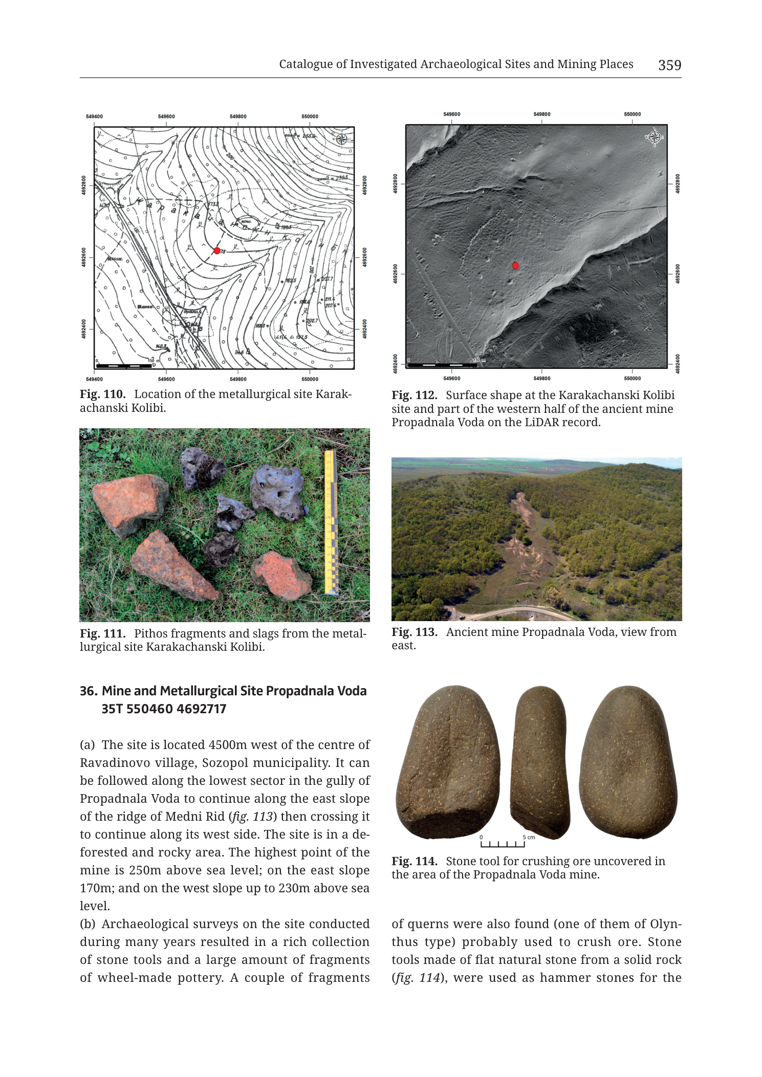
Fig. 110 (upper left) — topographic contour location map
Caption (below figure): Fig. 110. Location of the metallurgical site Karakachanski Kolibi.
Coordinate ticks (UTM metre grid):
- Top edge (west → east): 549400 | 549600 | 549800 | 550000
- Bottom edge (west → east): 549400 | 549600 | 549800 | 550000
- Left edge (north → south): 4692800 | 4692600 | 4692400
- Right edge (north → south): 4692800 | 4692600 | 4692400
North arrow: compass rose in upper-right corner of the map frame (N up).
Contour elevation labels visible on the map face (metres a.s.l.; selected clearly readable values):
- Northern high ground: 202.6, 198.5, and further labels in the 190–200 m band
- Central slopes around the red centroid: values in the ~170–190 m band (including labels near 180)
- Southern/lower ground: 160-range and lower teens-of-metres labels toward the SW corner (e.g. values near 140–160 where readable)
- Additional spot heights / contour numbers scattered across spurs and re-entrants (some partially crowded)
Map-face annotations:
- Solid red filled circle near map centre (metallurgical-site centroid).
- Numerous small open triangle symbols scattered across the contour field (survey find-spots / feature markers).
- Linear features: a road/track drawn as a double/parallel line crossing the southern half of the map roughly WNW–ESE to NW–SE; shorter track spurs.
- No separate graphical scale bar (scale implicit from 200 m grid).
Fig. 111 (middle left) — finds photograph
Caption (below figure): Fig. 111. Pithos fragments and slags from the metallurgical site Karakachanski Kolibi.
Photo: seven objects laid on short green grass, with a vertical yellow-and-black metric scale bar along the right edge (centimetre scale; numbered ticks ascending toward the top of the bar; top numerals include values in the 10–20 cm range as printed on the bar).
Objects (approximate layout, left → right / top → bottom as visible):
- Large thick-walled reddish ceramic body sherd (pithos fragment), upper left.
- Dark vesicular slag lump, upper centre.
- Dark irregular slag lump, upper right of centre.
- Elongate tapered reddish ceramic fragment (pithos/wall sherd), lower left.
- Small dark rounded slag piece, lower centre.
- Reddish ceramic sherd, lower right.
- [additional small dark slag piece near the upper slag group — present as a separate lump beside item 2/3].
No text labels on individual objects.
Fig. 112 (upper right) — LiDAR hillshade / DSM
Caption (below figure): Fig. 112. Surface shape at the Karakachanski Kolibi site and part of the western half of the ancient mine Propadnala Voda on the LiDAR record.
Coordinate ticks (UTM metre grid):
- Top edge (west → east): 549600 | 549800 | 550000
- Bottom edge (west → east): 549600 | 549800 | 550000
- Left edge (north → south): 4692800 | 4692600 | 4692400
- Right edge (north → south): 4692800 | 4692600 | 4692400
North arrow: compass rose in upper-right corner (N up).
Scale bar (bottom-left inside frame): 0 | 50 | 100 | 150 with unit “m”.
Map-face annotations:
- Solid red filled circle in the left-centre of the frame (Karakachanski Kolibi reference point).
- Greyscale hillshade of ridge-and-gully terrain; bright linear road cutting NW–SE across the lower-left quadrant; darker vegetated / shadowed slopes; a broad disturbed / mined hollow system occupying the right and upper-right portion of the frame (western workings of Propadnala Voda).
Fig. 113 (middle right) — oblique aerial photograph
Caption (below figure): Fig. 113. Ancient mine Propadnala Voda, view from east.
No coordinate frame, no scale bar, no overprinted labels on the photo. Content: forested ridge landscape with a large cleared / pale scar of mine workings on the near slope, dirt tracks, and distant open lowlands/coastal plain on the horizon under haze.
Fig. 114 (lower right) — artefact photograph
Caption (below figure): Fig. 114. Stone tool for crushing ore uncovered in the area of the Propadnala Voda mine.
Photo: three views of the same brownish ground-stone tool (or three related faces), arranged left / centre / right on a white background.
- Left: broad face, rounded ovate outline, slightly battered end.
- Centre: edge-on / side view, elongate, one end thicker.
- Right: opposite broad face, rounded ovate outline.
Scale bar below the trio: labelled 0 at left and 5 cm at right, with millimetre/centimetre ticks between.
Body text — lower left and continuing under Fig. 114 (catalogue entry 36)
36. Mine and Metallurgical Site Propadnala Voda 35T 550460 4692717
(a) The site is located 4500m west of the centre of Ravadinovo village, Sozopol municipality. It can be followed along the lowest sector in the gully of Propadnala Voda to continue along the east slope of the ridge of Medni Rid (fig. 113) then crossing it to continue along its west side. The site is in a de- forested and rocky area. The highest point of the mine is 250m above sea level; on the east slope 170m; and on the west slope up to 230m above sea level. (b) Archaeological surveys on the site conducted during many years resulted in a rich collection of stone tools and a large amount of fragments of wheel-made pottery. A couple of fragments
[text continues in the column beneath Fig. 114:]
of querns were also found (one of them of Olyn- thus type) probably used to crush ore. Stone tools made of flat natural stone from a solid rock (fig. 114), were used as hammer stones for the
[Page ends; entry 36 continues on the following page.]
No legend key block, no stratigraphic column, no table.
Description
TYPE & PURPOSE
Mixed catalogue plate from Krauss et al. (2020) that simultaneously:
- Finishes the illustration set for 35. Metallurgical Site Karakachanski Kolibi (Figs. 110–112, completing the figure citations made on the previous page).
- Opens the entry and first illustrations for 36. Mine and Metallurgical Site Propadnala Voda (header + fields a–b started; Figs. 113–114).
Propadnala Voda is one of the five principal named copper deposits of the Rosen ore field (southeasternmost of the classic NW–SE chain on Tzankova 2023 Fig. 1). This plate is the catalogue’s primary visual introduction to that mine together with the immediately adjacent Karakachanski Kolibi smelting scatter.
OVERALL PAGE LAYOUT
- Portrait monograph page; running head “Catalogue of Investigated Archaeological Sites and Mining Places”, page 359 at right.
- Two-column figure grid in the upper ~⅔:
- Row 1: Fig. 110 (contour map) | Fig. 112 (LiDAR)
- Row 2: Fig. 111 (finds photo) | Fig. 113 (aerial of mine)
- Row 3 area: entry-36 text (left) | Fig. 114 (stone tool) + continuation of (b) under it (right)
- No footer beyond page end.
Fig. 110 — Location of Karakachanski Kolibi
Type & purpose
Topographic contour location map placing the Karakachanski Kolibi metallurgical site on the west-slope foothills/mid-slope of Medni Rid, with survey find-spot symbols.
Frame, extent, orientation
- Rectangular contour map, UTM tick frame, north up (compass rose UR).
- Extent: Easting 549400–550000 (600 m); Northing 4692400–4692800 (400 m).
Scale
- No graphical scale bar.
- 200 m grid-label interval; frame = 600 × 400 m on the ground.
Coordinates / grid
- UTM metre ticks as transcribed. Zone 35T from catalogue centroids.
- Contours carry the planimetric detail; no full drawn graticule interior.
Relief & physiography
- Contour map (brown/sepia lines on white).
- Contour interval appears fine (on the order of 2–5 m given the density and the decimal spot-style labels such as 202.6 / 198.5); exact interval not printed as a legend note.
- Relief pattern: a high / ridge crest occupies the northern and north-eastern part of the frame (contours closing toward ~200+ m). Slopes fall generally south and south-west into lower ground (~140–170 m band) across the southern third.
- The red centroid sits on the mid-slope, consistent with the previous page’s text elevation of 160–180 m a.s.l. for site 35.
- Re-entrants and spurs indicate small gullies draining off the Medni Rid west flank.
Hydrography & coast
- No coast. No blue hydrography layer; drainage implied only by contour re-entrants. Inland west slope of Medni Rid.
Anthropogenic / cultural features
- Red filled circle = Karakachanski Kolibi centroid.
- Open triangles = dense scatter of survey points across the mid-slope and toward the ridge — the 2.5 ha slag-and-pottery scatter of site 35 (b) from the previous page.
- Road/track drawn through the southern half of the map (matches the dirt road in which slag is “easily detected” per site 35 text, and the bright road cutting on Fig. 112).
Geological content
- None classified on this topographic plate.
Colour & symbol system
- Black/brown contours and ticks; red centroid; open triangles; road as linear double-line symbol.
Spatial relationships
- Site sits west of the 550000 easting line, on the west flank of Medni Rid.
- Eastern edge of this map (E 550000) begins to approach the western side of the Propadnala Voda mine complex, which Fig. 112 extends into explicitly.
- Relative to Rosen village: 3120 m east (from prior page text) — consistent with a mid-ridge west-slope position inland of the Rosen ore-field core.
Consistency Check — Fig. 110 / Site 35
- Centroid (from prior page entry 35, and implied by this figure): 35T 549742 4692618
- Map bounds: Easting [549400–550000], Northing [4692400–4692800]
- Easting: 549400 ≤ 549742 ≤ 550000 → PASS
- Northing: 4692400 ≤ 4692618 ≤ 4692800 → PASS
- Result: PASS
Fig. 111 — Pithos fragments and slags from Karakachanski Kolibi
Type & purpose
Field/finds photograph illustrating the two principal portable-find classes from site 35: large ceramic (pithos) wall fragments and metallurgical slag.
View & content
- Vertical view onto short pasture grass.
- Ceramics: thick, coarse, oxidised red/orange pithos body sherds — one large curved wall fragment (upper left), one elongate tapered fragment (lower left), one smaller red sherd (lower right). Walls are thick enough to read as storage-jar / pithos rather than tableware, matching the caption.
- Slags: several dark grey to black, irregular, vesicular/ropy lumps (upper centre and right, small piece lower centre). Surfaces look dense at the crust with visible porosity — consistent with the previous page’s description of slag that is “dark, dense, porous inside and occasionally with traces of oxidised copper minerals” (green copper staining is not obvious at this photo’s resolution/lighting, but the dark vesicular morphology matches smelting slag).
- Scale: yellow staff with black centimetre bands along the right margin of the photo, establishing object sizes on the order of several to ~15+ cm for the larger sherds and a few centimetres for the smaller slag pieces.
Archaeological reading
- Direct material evidence for on-site metallurgical activity (slag) plus large ceramic containers (pithos) in the same scatter — supporting the interpretation of a primary smelting installation complex rather than a purely domestic assemblage.
Fig. 112 — LiDAR: Karakachanski Kolibi and western Propadnala Voda
Type & purpose
LiDAR hillshade/DSM showing (1) the surface context of the Karakachanski Kolibi metallurgical site and (2) part of the western half of the ancient mine Propadnala Voda, linking the smelting scatter to its nearest major ore source.
Frame, extent, orientation
- Rectangular greyscale LiDAR panel, UTM tick frame, north up.
- Extent from labels: Easting 549600–550000 (400 m labelled span; frame may include small margins beyond the outer labelled ticks); Northing 4692400–4692800 (400 m).
- Scale bar 0–150 m at bottom-left.
Relief & physiography (LiDAR)
- Hillshade emphasises:
- A ridge crest / upper slope belt running roughly through the upper and right portions of the frame.
- A broad anthropogenic hollow / pit-and-spoil complex on the eastern (right) side — the western workings of Propadnala Voda: irregular depressions, scalloped edges, and rough micro-topography distinct from smooth natural slopes.
- A bright linear road cutting crossing the lower-left to centre, matching Fig. 110’s mapped track.
- More subdued undulations on the left-centre around the red dot (metallurgical site pasture terrain — less dramatically excavated than the mine proper).
- Vegetation canopy texture is suppressed relative to bare-earth style relief; some tree-line roughness remains along slopes.
Anthropogenic features
- Red filled circle = Karakachanski Kolibi marker, west of the main mine hollows.
- Propadnala Voda western mine zone = right-hand disturbed ground.
- Road/track as above.
- Possible fainter linear fences or paths near the red dot (modern cattle fences mentioned in site 35 text).
Spatial relationships
- Demonstrates the short ground distance between the smelting scatter (red dot) and the western Propadnala Voda mine — catalogue text on the previous page placed site 35 650 m west of Propadnala Voda; this LiDAR frame captures both in one ~400–600 m window, i.e. the near side of that separation.
- Ore-to-smelter workflow implied: minerals from Propadnala Voda (and other nearby Medni Rid mines) processed at Karakachanski Kolibi on the west slope immediately below/beside the workings.
Consistency Check — Fig. 112
- Site-35 centroid 549742, 4692618 vs bounds E [549600–550000], N [4692400–4692800]:
- Easting: 549600 ≤ 549742 ≤ 550000 → PASS
- Northing: 4692400 ≤ 4692618 ≤ 4692800 → PASS
- Result: PASS (for the Karakachanski marker). Propadnala Voda mine body extends into the eastern half of the frame toward/beyond E 550000; site-36 centroid 550460 lies east of this frame’s eastern tick (see entry 36 check below).
Fig. 113 — Ancient mine Propadnala Voda, view from east
Type & purpose
Oblique aerial photograph of the Propadnala Voda mine landscape, looking west toward Medni Rid (caption: view from east).
View & content
- Foreground to middle ground: a large deforested pale scar of mine workings — bare earth, pit walls, spoil, and dirt tracks — cut into an otherwise forested ridge slope. The cleared area forms an irregular multi-lobed opening in the green canopy, with internal track Y-junctions and working hollows.
- A pale road curves along the lower (near) edge of the cleared zone.
- Surrounding slopes are densely wooded (mixed deciduous cover, spring/summer green).
- Background: further forested ridges; far horizon opens to a hazy lowland/coastal plain (Black Sea littoral plain north/east of Medni Rid), confirming the elevated ridge setting.
- Lighting: clear daylight, soft haze in the distance.
- No scale bar or overprinted coordinates; scale is landscape-level (hundreds of metres across the cleared mine complex).
Archaeological / mining reading
- Matches entry 36 (a): site “in a deforested and rocky area,” traceable from the Propadnala Voda gully along the east slope of Medni Rid, across the ridge, and down the west side. The photo shows the east-facing opening of that mine complex from the east, i.e. the viewer looks into the gully/east-slope workings toward the ridge crest.
Fig. 114 — Stone ore-crushing tool from Propadnala Voda
Type & purpose
Studio photograph of a ground-stone hammer / ore-crushing tool from the Propadnala Voda mine area, shown in three aspects.
Description of the object
- Material: dense, speckled brownish-grey stone (appears to be a hard volcanic or siliciclastic cobble; caption groups it with “flat natural stone from a solid rock” used as hammer stones).
- Form: elongated ovate / sub-rectangular cobble with rounded ends; one end slightly more battered/flattened from use.
- Three views:
- Left — face A: broad side, full ovate plan.
- Centre — profile: thickness view; tool is thicker at one end, tapering slightly; length dominates.
- Right — face B: opposite broad side.
- Scale: 0–5 cm bar beneath the set. Object length is on the order of ~10–12 cm (roughly 2× the 5 cm bar); width ~6–7 cm; thickness (centre view) a few centimetres.
- Use-wear: ends appear abraded/battered relative to the smoother mid-body — consistent with hammer-stone / ore-crushing function stated in caption and body text.
Relationship to text
- Illustrates the stone-tool industry of site 36 (b): hammer stones plus querns (including one Olynthus-type quern fragment, mentioned in the continuing text) interpreted as ore-crushing equipment.
Catalogue text — Site 36. Mine and Metallurgical Site Propadnala Voda
(Entry begins on this page; continues after the page break.)
- Header: 36. Mine and Metallurgical Site Propadnala Voda
- Centroid: 35T 550460 4692717
- (a) Location / setting:
- 4500 m west of the centre of Ravadinovo village, Sozopol municipality.
- Traceable along the lowest sector of the Propadnala Voda gully, then along the east slope of Medni Rid (fig. 113), across the ridge, and along the west side.
- Setting: deforested, rocky.
- Elevations: highest point of the mine 250 m a.s.l.; east slope 170 m; west slope up to 230 m.
- (b) Finds (started on this page):
- Multi-year surveys → rich collection of stone tools; large amount of wheel-made pottery fragments.
- Quern fragments, including one of Olynthus type, probably used to crush ore.
- Stone tools of flat natural stone from solid rock (fig. 114) used as hammer stones for the … [sentence continues on next page].
Fields (c)–(g) and the remainder of (b) are not on this PNG.
Consistency Check — Site 36 centroid
- Centroid (body text): 35T 550460 4692717
- No dedicated full-site location map for entry 36 alone is printed on this page. Fig. 113 is an ungridded aerial. Fig. 112’s eastern edge reaches E 550000, so the site-36 centroid (E 550460) lies ~460 m east of Fig. 112’s eastern labelled tick — i.e. just outside that LiDAR frame, consistent with Fig. 112 showing only the “western half” of the mine (caption wording).
- Sanity range (SE Bulgaria, UTM 35T): Easting 550460 ∈ ~530000–560000; Northing 4692717 ∈ ~4600000–4700000 → PASS (range only).
- Result: N/A (no full site-36 grid map on this page) — centroid accepted from body text. (A companion plan plate for Propadnala Voda exists elsewhere in the checklist as
Cat_p362_n36_Propadnala_Voda_mine_plan.png.)
SPATIAL RELATIONSHIPS (page-level)
- Karakachanski Kolibi (35) at 35T 549742 4692618 — west-slope metallurgical scatter (figs. 110–112), 160–180 m a.s.l., slag + pithos + pottery over 2.5 ha.
- Propadnala Voda (36) at 35T 550460 4692717 — ancient mine and metallurgical site straddling the Medni Rid crest via the Propadnala Voda gully; 170–250 m a.s.l.; stone ore-processing tools (fig. 114); aerial overview from the east (fig. 113).
- ΔE (36 − 35) ≈ +718 m, ΔN ≈ +99 m — site 36 lies roughly 0.7 km east of site 35, matching the previous page’s “650 m west of Propadnala Voda” distance for Karakachanski Kolibi (within rounding / centroid-vs-mine-body differences).
- Functional couplet: mine (36) + nearby primary smelting installations (35) on the west slope.
- Broader chain: Propadnala Voda is the SE member of the Rosen-field deposit alignment treated in Tzankova (2023) Fig. 1.
RELATIONSHIP TO OTHER FIGURES
- Figs. 110–112 complete site 35 (cited as fig. 110/111/112 on the previous catalogue page).
- Figs. 113–114 open site 36; further Propadnala Voda plans/sections appear on subsequent catalogue pages / companion PNGs in this folder.
- Geological context: Tzankova (2023) Fig. 1 deposit symbol “Propadnala Voda”; other Medni Rid plates (Tub_* series) treat the same ore field structurally.
Notes
- Printed page header reads 359; PNG filename uses p361. Same off-by-two filename-vs-print pattern as the preceding catalogue plates. page_hint follows the printed number.
- This plate is shared by sites 35 and 36; the filename flags Propadnala Voda (36), but three of five figures are Karakachanski Kolibi (35).
- Entry 36 is incomplete on this page (cuts off mid-sentence in (b)); do not treat as a full catalogue record.
- Contour interval on Fig. 110 is not stated; decimal labels (e.g. 202.6) may be spot heights rather than every contour. Readable values listed; crowded labels marked only where clear.
- Fig. 112 caption explicitly says “part of the western half” of Propadnala Voda — so absence of centroid 550460 inside that frame is expected, not a transcription error.
- Olynthus-type quern: a hopper-rubber mill form of Classical/Hellenistic date — chronological hint aligning with Greek/Roman attributions used for neighbouring sites in this catalogue stretch.
- No Cyrillic on this page (unlike the prior plate’s bibliography lines).