Description
Transcription
Page header (top rule line):
- Left: 358
- Centre/right: Petar Leshtakov, Kalin Dimitrov, Jonas Abele, René Kunze, Ernst Pernicka, and Raiko Krauss
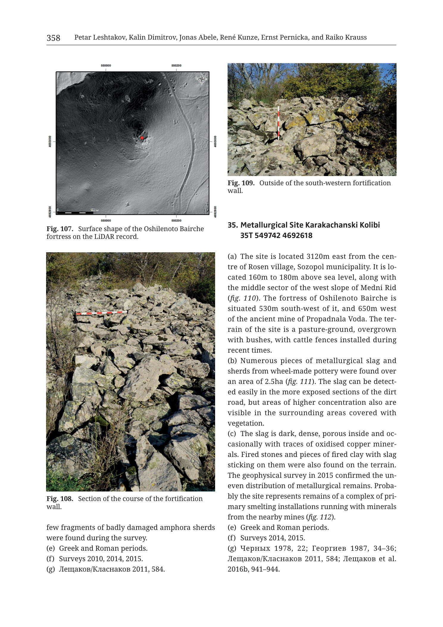
Fig. 107 (upper left) — LiDAR hillshade / DSM
Caption (below figure): Fig. 107. Surface shape of the Oshilenoto Bairche fortress on the LiDAR record.
Coordinate ticks (UTM metre grid, labels outside the image frame):
- Top edge: 550000 | 550200
- Bottom edge: 550000 | 550200
- Left edge (north → south): 4693100 | 4692800
- Right edge (north → south): 4693100 | 4692800
North arrow: compass rose in upper-right corner of the LiDAR frame (N up).
Scale bar (bottom-left inside frame): segmented bar labelled 0 | 50 | 100 | 150 | 200 with unit “m”.
Map-face annotations:
- Solid red filled circle near the centre of a raised circular/elliptical earthwork (fortress centroid / reference point).
- Grey-scale LiDAR hillshade showing a clear ring-shaped rampart enclosing a slightly dished interior, with radial/linear scars and tracks around it.
No separate legend. No contour values printed (relief is hillshade only).
Fig. 108 (middle/lower left) — ground photograph
Caption (below figure): Fig. 108. Section of the course of the fortification wall.
Photo content labels: none printed on the image itself.
Scale: horizontal ranging pole / scale bar laid across the stone collapse in the middle ground — segmented red-and-white rod (decimetre/metre bands; individual band labels not legible at this resolution).
Fig. 109 (upper right) — ground photograph
Caption (below figure): Fig. 109. Outside of the south-western fortification wall.
Photo content labels: none printed on the image itself.
Scale: vertical red-and-white ranging pole standing among the stones near the left-centre of the rubble mass (band labels not legible at this resolution).
Body text — lower left column (tail of prior catalogue entry = Oshilenoto Bairche fortress)
few fragments of badly damaged amphora sherds were found during the survey. (e) Greek and Roman periods. (f) Surveys 2010, 2014, 2015. (g) Лещаков/Класнаков 2011, 584.
Translation (Cyrillic in (g)): Leshtakov/Klasnakov 2011, 584.
Body text — right column (catalogue entry 35)
35. Metallurgical Site Karakachanski Kolibi 35T 549742 4692618
(a) The site is located 3120m east from the cen- tre of Rosen village, Sozopol municipality. It is lo- cated 160m to 180m above sea level, along with the middle sector of the west slope of Medni Rid (fig. 110). The fortress of Oshilenoto Bairche is situated 530m south-west of it, and 650m west of the ancient mine of Propadnala Voda. The ter- rain of the site is a pasture-ground, overgrown with bushes, with cattle fences installed during recent times. (b) Numerous pieces of metallurgical slag and sherds from wheel-made pottery were found over an area of 2.5ha (fig. 111). The slag can be detect- ed easily in the more exposed sections of the dirt road, but areas of higher concentration also are visible in the surrounding areas covered with vegetation. (c) The slag is dark, dense, porous inside and oc- casionally with traces of oxidised copper miner- als. Fired stones and pieces of fired clay with slag sticking on them were also found on the terrain. The geophysical survey in 2015 confirmed the un- even distribution of metallurgical remains. Proba- bly the site represents remains of a complex of pri- mary smelting installations running with minerals from the nearby mines (fig. 112). (e) Greek and Roman periods. (f) Surveys 2014, 2015. (g) Черных 1978, 22; Георгиев 1987, 34–36; Лещаков/Класнаков 2011, 584; Лещаков et al. 2016b, 941–944.
Translation (Cyrillic author names in (g)): Chernykh 1978, 22; Georgiev 1987, 34–36; Leshtakov/Klasnakov 2011, 584; Leshtakov et al. 2016b, 941–944.
No map legend key, no stratigraphic column, no table on this page. Figs. 110, 111, 112 cited for site 35 are not printed on this page.
Description
TYPE & PURPOSE
Mixed catalogue plate from Krauss et al. (2020). The page combines:
- Fig. 107 — LiDAR-derived surface-shape (hillshade/DSM) plan of the Oshilenoto Bairche fortress (prior catalogue entry).
- Fig. 108 — Ground photograph of a section of that fortress’s fortification-wall course (collapsed stone rampart).
- Fig. 109 — Ground photograph of the outside of the south-western fortification wall of the same fortress.
- Catalogue text completing the prior fortress entry (fields e–g tail) and the full entry for 35. Metallurgical Site Karakachanski Kolibi.
The PNG filename targets the Karakachanski Kolibi metallurgical site (entry 35). All three printed figures, however, document the neighbouring Oshilenoto Bairche fortress; site 35’s own illustrations (figs. 110 location, 111 slag/scatter, 112 smelting-installations interpretation) are cited in the text but not reproduced here.
OVERALL PAGE LAYOUT
- Portrait monograph page.
- Header: page number 358 at left; full author string at right.
- Upper tier: Fig. 107 (LiDAR) left; Fig. 109 (SW wall photo) right, with entry-35 header and body starting immediately under Fig. 109.
- Middle/lower left: Fig. 108 (wall-course photo), then the tail paragraphs of the prior entry beneath it.
- Right column below entry header: full site-35 (a)–(g) text.
- No separate footer.
Fig. 107 — LiDAR surface shape of Oshilenoto Bairche fortress
Type & purpose
LiDAR hillshade / digital surface model used to reveal the plan of a small hilltop/knoll fortress (Oshilenoto Bairche) that is otherwise under vegetation. Purpose: show the ring rampart and interior hollow that define the fortification in plan.
Frame, extent, orientation
- Square-ish greyscale panel with UTM metre tick frame.
- North up (compass rose, upper-right).
- Labelled ticks: Easting 550000 and 550200; Northing 4693100 and 4692800.
- From the two northing labels the N–S span of the labelled ticks is 300 m; the 0–200 m scale bar occupies roughly one-third of the frame width, implying an E–W ground width on the order of ~600 m. Exact outer-tick values at the frame corners are not printed beyond the two easting and two northing labels listed above — corner coordinates are therefore not over-specified here.
Scale
- Graphical scale bar bottom-left: 0–200 m in 50 m segments.
- No ratio scale.
Coordinates / grid
- UTM metre ticks as transcribed. Zone implied 35T from catalogue centroids on this page and throughout the volume.
- No interior drawn graticule; hillshade is continuous.
Relief & physiography (LiDAR)
- Greyscale hillshade illuminated to emphasise micro-relief.
- Dominant feature: a nearly circular to slightly elliptical raised ring (rampart) enclosing a subtly lower interior courtyard — classic small fortified enclosure signature in LiDAR.
- The ring sits on a local high; ground falls away around it, with a brighter (higher/more reflective in the shade model) apron on parts of the perimeter.
- Linear features:
- Curved/straight pale tracks or hollow-ways skirt the fort on the south and east.
- Several short linear scars and possible ditch/bank segments outside the main ring.
- A broader pale linear feature crosses the lower (southern) third of the frame — likely a modern or historic track/road in a shallow cutting.
- No absolute elevation numbers or contour lines are printed on this panel (contrast with pure contour maps elsewhere in the catalogue).
Hydrography & coast
- No coast. No mapped streams. Inland Medni Rid west-slope setting (per accompanying site-35 text placing the related fortress relative to Medni Rid / Propadnala Voda).
Anthropogenic / cultural features
- Ring rampart of Oshilenoto Bairche — the primary archaeological signal.
- Red filled circle on the eastern/central part of the ring interior or inner rampart crest — fortress reference/centroid marker used for the catalogue figure.
- Surrounding trackways and possible outer works as noted above.
- No building footprints resolved inside the ring at this display scale beyond the general dished interior.
Geological content
- None classified. Bedrock/soil not differentiated; LiDAR shows surface geometry only.
Colour & symbol system
- Greyscale hillshade (light = locally high or illumination-facing; dark = low or shadowed).
- Red centroid; black ticks/scale/north arrow; white frame background outside the DSM.
Spatial relationships
- Fortress forms a compact closed circuit on a local eminence.
- Per site-35 (a): Oshilenoto Bairche lies 530 m south-west of Karakachanski Kolibi (35T 549742 4692618) and the metallurgical site itself is 650 m west of the ancient mine of Propadnala Voda (word order in the sentence attaches “650 m west of Propadnala Voda” after the fortress clause; geographically both loci sit in the Propadnala Voda–Medni Rid west-slope cluster).
- LiDAR eastings around 550000 place the fortress slightly east of the site-35 centroid easting 549742, which should be reconciled against the “530 m SW” bearing when fig. 110 (site-35 location map, not on this page) is available — see Notes.
Relationship to other figures
- Figs. 108–109 are ground photos of the same fortification’s wall fabric.
- Prior-entry text tail under Fig. 108 belongs to this fortress entry.
- Site 35 text cross-references the fortress as a nearby landmark.
Consistency Check — Fig. 107 / Oshilenoto Bairche
- No explicit “35T …… ……” centroid for Oshilenoto Bairche is printed on this page (header of that entry is on a previous page).
- Labelled ticks: Easting markers 550000 and 550200; Northing markers 4692800 and 4693100.
- Result: N/A (centroid not on page). Tick values lie inside the valid SE-Bulgaria UTM 35T range.
Fig. 108 — Section of the fortification wall course
Type & purpose
Oblique ground photograph documenting the fabric and collapse state of a stretch of the Oshilenoto Bairche fortification wall.
View & content
- Viewpoint: standing on or beside the wall line, looking along a linear mound of loosely piled, angular to sub-angular grey limestone (or similar local carbonate/volcanic float) blocks.
- The wall is not freestanding ashlar; it appears as a collapsed dry-stone rubble bank / tumble forming a raised linear course running away from the camera into the middle distance.
- Blocks are lichen-stained (yellow-green patches), of mixed cobble-to-boulder size, without visible mortar.
- Vegetation: dry grasses and low herbs in the foreground left; shrubs and small trees (green and autumn-brown foliage) framing left and right and closing the background under a clear blue sky.
- Scale: red-and-white horizontal ranging pole laid across the rubble in the middle ground, giving an approximate width reference for the wall tumble (on the order of one to a few metres across the visible crest; exact calibrated length of the pole not printed).
Archaeological reading
- Illustrates the “course of the fortification wall” as a rubble rampart rather than an intact elevation — consistent with a ruined Greek/Roman-period hillfort wall after long collapse and stone scatter.
- No dressed faces, towers, or gate detail are identifiable in this frame.
Fig. 109 — Outside of the south-western fortification wall
Type & purpose
Closer ground photograph of the exterior face/tumble of the south-western sector of the same rampart.
View & content
- Viewpoint: outside the enclosure, looking into a steep pile of large angular grey blocks that form the outer batter or collapse apron of the SW wall.
- Blocks are larger on average than in the mid-distance of Fig. 108; many show rough fracture faces and heavy lichen cover.
- Scale: vertical red-and-white ranging pole planted among the stones left of centre, establishing the height of the rubble pile (visually on the order of ~1–1.5+ m of exposed stone above the local ground in this view; pole length not numerically labelled).
- Background: dense green shrub/tree canopy under blue sky with thin cloud — the fort is under active scrub cover, matching the need for LiDAR (Fig. 107) to recover plan geometry.
- No cut stone, mortar, or inscribed blocks visible.
Relationship of Figs. 108–109 to Fig. 107
- Fig. 107 gives the closed-ring plan; Figs. 108–109 sample the wall fabric at ground level, including the specifically identified SW exterior.
Catalogue text — prior entry tail (Oshilenoto Bairche fortress)
Fields closing the fortress entry on this page:
- Final finds note: few fragments of badly damaged amphora sherds found during the survey.
- (e) Chronology: Greek and Roman periods.
- (f) Research history: Surveys 2010, 2014, 2015.
- (g) Bibliography: Лещаков/Класнаков 2011, 584.
(Opening fields a–d and the entry header for this fortress sit on the preceding page, not in this PNG.)
Catalogue text — Site 35. Metallurgical Site Karakachanski Kolibi
Full entry present on this page:
- Header: 35. Metallurgical Site Karakachanski Kolibi
- Centroid: 35T 549742 4692618
- (a) Location / setting:
- 3120 m east of the centre of Rosen village, Sozopol municipality.
- 160–180 m above sea level.
- Middle sector of the west slope of Medni Rid (fig. 110 — not on this page).
- Fortress Oshilenoto Bairche 530 m south-west of the site.
- 650 m west of the ancient mine of Propadnala Voda.
- Terrain: pasture overgrown with bushes; modern cattle fences.
- (b) Finds / scatter:
- Numerous metallurgical slag pieces and wheel-made pottery sherds over 2.5 ha (fig. 111 — not on this page).
- Slag easily seen in exposed dirt-road sections; higher-concentration patches also under vegetation.
- (c) Metallurgical character / interpretation:
- Slag: dark, dense, porous inside; occasional traces of oxidised copper minerals.
- Also: fired stones; pieces of fired clay with slag adhering.
- 2015 geophysical survey confirmed uneven distribution of metallurgical remains.
- Interpreted as remains of a complex of primary smelting installations processing minerals from the nearby mines (fig. 112 — not on this page).
- (e) Chronology: Greek and Roman periods.
- (f) Research history: Surveys 2014, 2015.
- (g) Bibliography: Черных 1978, 22; Георгиев 1987, 34–36; Лещаков/Класнаков 2011, 584; Лещаков et al. 2016b, 941–944.
Field (d) is not printed (schema skip, as elsewhere in the catalogue when unused).
Name-form note: filename uses “Karakachanski_Kolibi”; printed header is “Karakachanski Kolibi” (same name, catalogue orthography).
Consistency Check — Site 35 centroid (no site-35 map on this page)
- Centroid (body text): 35T 549742 4692618
- No map frame for site 35 is printed on this page (fig. 110 absent), so axis-bracket checks cannot be run here.
- Sanity range (SE Bulgaria, UTM 35T): Easting 549742 ∈ ~530000–560000; Northing 4692618 ∈ ~4600000–4700000 → PASS (range only).
- Result: N/A (no map) — accept body-text centroid; verify on fig. 110 when described.
SPATIAL RELATIONSHIPS (page-level)
- Karakachanski Kolibi (35) — west slope of Medni Rid, 160–180 m a.s.l., 3.12 km east of Rosen village, 0.65 km west of Propadnala Voda mine; 2.5 ha slag-and-pottery scatter interpreted as primary copper smelting installations of Greek/Roman date.
- Oshilenoto Bairche fortress — small ring-rampart fort (LiDAR + wall photos on this page), Greek/Roman, 530 m from the metallurgical site (text: south-west of it); amphora sherds from survey.
- Propadnala Voda — major ancient mine of the Rosen ore field, used here as a distance reference (650 m from the metallurgical site per the catalogue sentence).
- Functional reading implied by the catalogue: smelting site on the west slope processing ore from nearby Medni Rid mines (explicitly “minerals from the nearby mines”), with a contemporary/nearby fortified point at Oshilenoto Bairche.
- Relative to the broader deposit chain (Rosen – Korucheshme – Meden Rid – Sarneshko Kladenche – Propadnala Voda): this metallurgical site clusters with the southern/SE end of that chain around Propadnala Voda rather than with the coastal settlements.
RELATIONSHIP TO OTHER FIGURES
- Figs. 107–109 → Oshilenoto Bairche fortress (prior entry).
- Fig. 110 (cited, not shown) → site 35 location.
- Fig. 111 (cited, not shown) → slag/pottery scatter over 2.5 ha.
- Fig. 112 (cited, not shown) → primary smelting-installations interpretation.
- Geological deposit context: Propadnala Voda appears on Tzankova (2023) Fig. 1 and on other Medni Rid plates in this collection.
Notes
- Printed page header reads 358, while the PNG filename uses p360. Description follows the printed header for page_hint; filename is recorded under
image:. Same off-by-two pattern noted for the Surneshko plate (filename p358 vs printed 356). - All three figures on this page illustrate Oshilenoto Bairche, not Karakachanski Kolibi — critical for figure-to-site indexing by filename alone.
- Site 35 entry is complete on this page (a–c, e–g), but its three cited figures (110–112) are absent from this PNG.
- Bearing check: text places Oshilenoto Bairche 530 m south-west of Karakachanski Kolibi (549742, 4692618), yet Fig. 107’s labelled eastings (~550000–550200) lie east of 549742. Possible explanations: (1) additional unlabelled frame margin west of 550000 contains the fort and the red dot’s true easting is <550000; (2) catalogue bearing/distance wording attaches differently than read; (3) the red dot is a figure highlight not the named centroid. Flag for reconciliation against fig. 110 and the fortress entry header on the previous page — body-text centroid for site 35 remains the authoritative catalogue coordinate.
- Contour/elevation numerics are absent on the LiDAR panel; 160–180 m a.s.l. for site 35 comes only from text.
- Slag description (dark, dense, porous, oxidised copper traces; fired clay with adhering slag) is the principal archaeometallurgical content on this page.
- Orthography: “Oshilenoto Bairche” as printed; “Karakachanski Kolibi” as printed.
- Field letter (d) omitted for site 35 — transcribed as shown.