Description
Transcription
Page header (top rule line):
- Left: 356
- Centre/right: Petar Leshtakov, Kalin Dimitrov, Jonas Abele, René Kunze, Ernst Pernicka, and Raiko Krauss
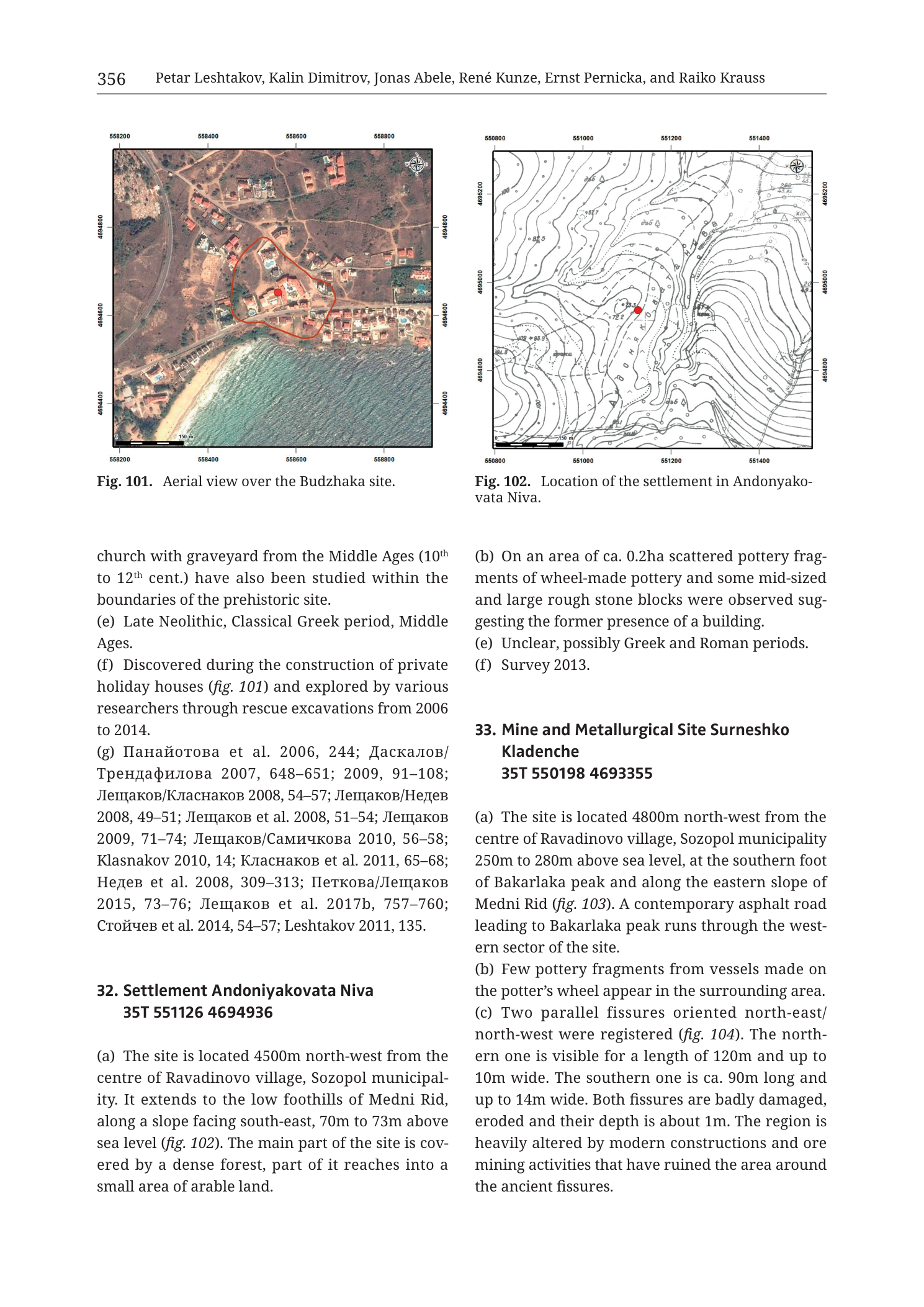
Fig. 101 (upper left) — aerial photograph with coordinate frame
Caption (below figure): Fig. 101. Aerial view over the Budzhaka site.
Coordinate ticks (UTM metre grid, labels outside the image frame):
- Top edge (west → east): 558200 | 558400 | 558600 | 558800
- Bottom edge (west → east): 558200 | 558400 | 558600 | 558800
- Left edge (north → south): 4694800 | 4694600 | 4694400
- Right edge (north → south): 4694800 | 4694600 | 4694400
North arrow: compass rose in upper-right corner of the photo frame (N up).
Scale bar (bottom-left inside photo): segmented bar labelled 0 | 50 | 100 | 150 with unit “m” at right end.
Map-face annotations:
- Irregular closed red polygon outlining a cluster of buildings near the centre of the photo.
- Solid red filled circle inside that polygon (site centroid marker).
Fig. 102 (upper right) — topographic contour map
Caption (below figure): Fig. 102. Location of the settlement in Andonyakovata Niva.
Coordinate ticks (UTM metre grid):
- Top edge (west → east): 550800 | 551000 | 551200 | 551400
- Bottom edge (west → east): 550800 | 551000 | 551200 | 551400
- Left edge (north → south): 4695200 | 4695000 | 4694800 | 4694600
- Right edge (north → south): 4695200 | 4695000 | 4694800 | 4694600
North arrow: compass rose in upper-right corner of the map frame (N up).
Contour elevation labels visible on the map face (metres a.s.l., selected readable values):
- Northern high ground: 85, 80, 75, 70, 65
- Western/central slopes: 60, 55, 50, 45, 40, 35
- Southern/lower ground: 30, 25, 20, 15 [some labels small/partially crowded]
Map-face annotations:
- Solid red filled circle near map centre (site centroid), sitting on the mid-slope contour field roughly between the 40 m and 50 m contours.
- Sparse small open triangle symbols scattered on the northern and western slopes (survey/find markers).
No separate scale bar printed on Fig. 102 (scale is implicit from the 200 m grid spacing).
Body text — left column (continuation of prior catalogue entry, then entry 32)
[Continuation of a previous site entry — Budzhaka context, paragraphs trailing into this page:]
church with graveyard from the Middle Ages (10th to 12th cent.) have also been studied within the boundaries of the prehistoric site. (e) Late Neolithic, Classical Greek period, Middle Ages. (f) Discovered during the construction of private holiday houses (fig. 101) and explored by various researchers through rescue excavations from 2006 to 2014. (g) Панайотова et al. 2006, 244; Даскалов/ Трендафилова 2007, 648–651; 2009, 91–108; Лещаков/Класнаков 2008, 54–57; Лещаков/Недев 2008, 49–51; Лещаков et al. 2008, 51–54; Лещаков 2009, 71–74; Лещаков/Самичкова 2010, 56–58; Klasnakov 2010, 14; Класнаков et al. 2011, 65–68; Недев et al. 2008, 309–313; Петкова/Лещаков 2015, 73–76; Лещаков et al. 2017b, 757–760; Стойчев et al. 2014, 54–57; Leshtakov 2011, 135.
Translation (Cyrillic author names in (g)): Panayotova; Daskalov/Trendafilova; Leshtakov/Klasnakov; Leshtakov/Nedev; Leshtakov; Leshtakov/Samichkova; Klasnakov; Nedev; Petkova/Leshtakov; Stoychev.
32. Settlement Andoniyakovata Niva 35T 551126 4694936
(a) The site is located 4500m north-west from the centre of Ravadinovo village, Sozopol municipal- ity. It extends to the low foothills of Medni Rid, along a slope facing south-east, 70m to 73m above sea level (fig. 102). The main part of the site is cov- ered by a dense forest, part of it reaches into a small area of arable land.
Body text — right column (continuation of entry 32, then entry 33)
(b) On an area of ca. 0.2ha scattered pottery frag- ments of wheel-made pottery and some mid-sized and large rough stone blocks were observed sug- gesting the former presence of a building. (e) Unclear, possibly Greek and Roman periods. (f) Survey 2013.
33. Mine and Metallurgical Site Surneshko Kladenche 35T 550198 4693355
(a) The site is located 4800m north-west from the centre of Ravadinovo village, Sozopol municipality 250m to 280m above sea level, at the southern foot of Bakarlaka peak and along the eastern slope of Medni Rid (fig. 103). A contemporary asphalt road leading to Bakarlaka peak runs through the west- ern sector of the site. (b) Few pottery fragments from vessels made on the potter’s wheel appear in the surrounding area. (c) Two parallel fissures oriented north-east/ north-west were registered (fig. 104). The north- ern one is visible for a length of 120m and up to 10m wide. The southern one is ca. 90m long and up to 14m wide. Both fissures are badly damaged, eroded and their depth is about 1m. The region is heavily altered by modern constructions and ore mining activities that have ruined the area around the ancient fissures.
[Page ends; entry 33 continues on the following page — not in this PNG. Figs. 103 and 104 referenced for site 33 are not printed on this page.]
No legend key blocks, no stratigraphic column, no table.
Description
TYPE & PURPOSE
Mixed catalogue plate from the Krauss et al. (2020) Tübingen monograph site catalogue. The page carries:
- Fig. 101 — orthophoto / aerial site plan of the Budzhaka prehistoric settlement (referenced from the trailing paragraphs of the preceding catalogue entry on this page).
- Fig. 102 — topographic contour location map of catalogue entry 32. Settlement Andoniyakovata Niva.
- Catalogue body text completing the prior entry (Budzhaka context: periods, discovery history, bibliography), the full short entry for site 32, and the opening paragraphs of entry 33. Mine and Metallurgical Site Surneshko Kladenche.
Primary research purpose of the plate as named by the PNG filename is the Surneshko (Sarneshko) Kladenche mine/metallurgical site (entry 33), whose descriptive text begins here; the two printed figures actually illustrate the preceding coastal settlement (Budzhaka) and the nearby foothill settlement (Andoniyakovata Niva). Site 33’s own figures (fig. 103 location; fig. 104 fissures) are cited but not reproduced on this page.
OVERALL PAGE LAYOUT
- Standard monograph page, portrait orientation.
- Header with page number 356 at left and full author line at right.
- Upper half: two equal-width square-ish map panels side by side (Fig. 101 left, Fig. 102 right), each with its own UTM coordinate frame, north arrow, and caption beneath.
- Lower half: two-column running catalogue text.
- No footer beyond the natural page end.
Fig. 101 — Aerial view over the Budzhaka site
Type & purpose
True-colour vertical (or near-vertical) aerial photograph used as a site-location plan. It shows the modern holiday-house development that led to discovery of the prehistoric site, with the investigated/site area outlined.
Frame, extent, orientation
- Rectangular photo frame with a full UTM metre tick border on all four sides.
- North up (compass rose, upper-right corner of the photo).
- Ground extent from coordinates: Easting 558200–558800 (600 m E–W); Northing 4694400–4694800 (400 m N–S). The photo therefore covers a coastal strip about 0.6 × 0.4 km.
Scale
- Scale bar bottom-left: 0–150 m in 50 m segments.
- No ratio scale printed.
- Consistent with the 200 m grid-label spacing on the frame (labels every 200 m).
Coordinates / grid
- UTM metre ticks as transcribed above. Implied zone from body-text centroids elsewhere on the page / catalogue convention: UTM 35T (WGS-style easting/northing).
- No interior grid lines drawn across the photo; only the frame ticks.
Relief & physiography
- Relief is photographic, not contoured.
- Southern third of the frame is an open sandy beach and nearshore zone (pale beige/white sand, sparse beach vegetation), indicating the Black Sea shore along the south edge.
- Land rises gently northward from the beach into a low coastal terrace occupied by buildings, lawns, pools, and scattered trees/shrubs.
- No elevation numbers on the photo itself.
Hydrography & coast
- Open sea / surf zone occupies the southern margin (bottom of frame).
- Beach runs approximately E–W across the south edge.
- No named rivers or lakes.
Anthropogenic / cultural features
- Dense modern holiday architecture: red-tiled and flat-roofed villas, swimming pools (bright turquoise rectangles), paved drives, garden plots, and perimeter walls/hedges — typical Black Sea resort parcel fabric.
- A dirt/paved lane system threads between parcels.
- Red closed polygon encloses a central cluster of several buildings and yards near mid-frame; this is the Budzhaka site outline referenced in the text (“private holiday houses (fig. 101)”).
- Red filled circle inside the polygon marks the catalogue site centroid.
- No ancient architectural remains are photographically resolvable at this scale; the archaeology is subsurface / previously excavated within this built fabric.
Geological content
- None mapped. Substrate is not classified. Beach sand and vegetated coastal terrace only.
Colour & symbol system
- Natural aerial palette (vegetation browns/greens, roof terracotta, pool cyan, beach pale).
- Overprint: red site outline + red centroid dot; black coordinate frame; black scale bar; black north arrow.
Spatial relationships
- The Budzhaka site polygon sits on the first terrace inland of the beach, not on the sand itself, amidst modern holiday houses.
- Sea immediately south; denser tree cover and further parcels north and east of the outline.
- Relative to other sites on this page: Budzhaka is a coastal site (easting ~558xxx) well east of the Medni Rid foothill sites 32 and 33 (easting ~550–551xxx).
Relationship to other figures
- Cited from the trailing (f) paragraph of the preceding catalogue entry on this page.
- Companion text on periods, discovery (2006–2014 rescue excavations), and bibliography occupies the upper left column.
Consistency Check — Fig. 101 / Budzhaka
- No explicit “35T …… ……” centroid for Budzhaka is printed on this page (that centroid belongs to the prior entry’s header, not repeated here).
- Map bounds: Easting [558200–558800], Northing [4694400–4694800].
- Result: N/A on this page (centroid not restated). Bounds are internally consistent (Easting high-550000s coastal strip; Northing mid-4694000s) and match the SE Bulgaria UTM 35T expected range.
Fig. 102 — Location of the settlement in Andonyakovata Niva
Type & purpose
Topographic contour location map placing catalogue site 32 (Andoniyakovata Niva / Andonyakovata Niva) on the low SE-facing foothills of Medni Rid.
Frame, extent, orientation
- Rectangular line-drawn map with full UTM tick border.
- North up (compass rose, upper-right).
- Ground extent: Easting 550800–551400 (600 m E–W); Northing 4694600–4695200 (600 m N–S). Approximately 0.6 × 0.6 km.
Scale
- No graphical scale bar.
- Grid labels every 200 m; the frame therefore represents 600 m on each side, giving an implicit metric scale.
Coordinates / grid
- UTM metre ticks as transcribed. Zone implied 35T from the site-32 header coordinate “35T 551126 4694936”.
- No full interior graticule drawn; contours carry the planimetric content.
Relief & physiography
- Contour map (brown/sepia contour lines on white).
- Contour interval appears to be 5 m (labels at 15, 20, 25, 30, 35, 40, 45, 50, 55, 60, 65, 70, 75, 80, 85 m where readable).
- Relief pattern: a broad high / ridge crest occupies the northern third of the map (closed and tightly spaced contours up to ~85 m), with slopes falling away south and south-east toward lower ground (~15–30 m) at the southern frame edge.
- Contours are relatively open on the mid-slopes and tighten on the northern crest and on local spurs, indicating moderate foothill topography rather than cliffed terrain.
- This matches the text description: “low foothills of Medni Rid, along a slope facing south-east, 70 m to 73 m above sea level.”
Hydrography & coast
- No coast in frame (inland foothill map).
- No named streams; contour re-entrants on the southern slopes imply shallow drainage lines but none are drawn as blue hydrography.
Anthropogenic / cultural features
- Red filled circle near centre = site 32 centroid, on the SE-facing mid-slope.
- Small open triangle symbols scattered mainly on the northern high ground and western slopes — survey find-spots or feature markers (not keyed on this figure).
- No roads, buildings, or fortress symbols drawn.
Geological content
- None. Pure topography + point symbols.
Colour & symbol system
- Black/brown contours and ticks on white.
- Red centroid; small open triangles for subsidiary points; black north arrow.
Spatial relationships
- Site sits on the SE-facing slope below a ~80–85 m local high to the north, consistent with “slope facing south-east” and the stated 70–73 m a.s.l. elevation (centroid sits near the 70 m contour band).
- Relative to site 33 (Surneshko Kladenche, centroid 35T 550198 4693355): site 33 lies roughly 1 km south-west of site 32 (ΔE ≈ −928 m, ΔN ≈ −1581 m), at much higher elevation (250–280 m) on the eastern slope of Medni Rid / southern foot of Bakarlaka — i.e. further up the ridge system, not on this foothill map.
- Relative to Ravadinovo: text places site 32 4500 m NW of the village centre; site 33 4800 m NW of the same village.
Relationship to other figures
- Directly illustrates entry 32 (a): “(fig. 102)”.
- No cross-section or inset on this panel.
Consistency Check — Fig. 102 / Site 32
- Centroid (body text): 35T 551126 4694936
- Map bounds: Easting [550800–551400], Northing [4694600–4695200]
- Easting: 550800 ≤ 551126 ≤ 551400 → PASS
- Northing: 4694600 ≤ 4694936 ≤ 4695200 → PASS
- Result: PASS
Catalogue text — Site 32. Settlement Andoniyakovata Niva
Structured catalogue entry (standard Krauss et al. 2020 schema; fields present on this page):
- Header: 32. Settlement Andoniyakovata Niva
- Centroid: 35T 551126 4694936
- (a) Location / setting: 4500 m NW of Ravadinovo village centre, Sozopol municipality; low foothills of Medni Rid; SE-facing slope; 70–73 m a.s.l.; illustrated by fig. 102. Main part under dense forest; part extends into a small area of arable land.
- (b) Finds / features: ca. 0.2 ha scatter of wheel-made pottery fragments; mid-sized and large rough stone blocks suggesting a former building.
- (e) Chronology: Unclear, possibly Greek and Roman periods.
- (f) Research history: Survey 2013.
(Fields (c), (d), (g) are not printed for site 32 on this page — either unused or omitted for this short entry.)
Name-form note: caption of Fig. 102 uses “Andonyakovata Niva”; entry header uses “Andoniyakovata Niva” (extra “i”). Both refer to the same site.
Catalogue text — Site 33. Mine and Metallurgical Site Surneshko Kladenche
(This is the filename target site. Only the opening of the entry appears on this page.)
- Header: 33. Mine and Metallurgical Site Surneshko Kladenche
- Centroid: 35T 550198 4693355
- (a) Location / setting: 4800 m NW of Ravadinovo village centre, Sozopol municipality; 250–280 m a.s.l.; southern foot of Bakarlaka peak and along the eastern slope of Medni Rid; illustrated by fig. 103 (not on this page). A modern asphalt road to Bakarlaka peak crosses the western sector of the site.
- (b) Finds: Few wheel-made pottery fragments in the surrounding area.
- (c) Mining features: Two parallel fissures oriented north-east / north-west (illustrated by fig. 104, not on this page):
- Northern fissure: visible length 120 m, width up to 10 m.
- Southern fissure: length ca. 90 m, width up to 14 m.
- Both badly damaged and eroded; depth about 1 m.
- Surroundings heavily altered by modern constructions and ore-mining activity that have ruined the area around the ancient fissures.
Entry continues on the next page (further catalogue fields and any metallurgical detail beyond the fissures are not in this PNG). Figs. 103–104 belonging to this site are not printed here.
Name-form note: printed “Surneshko Kladenche” corresponds to the Rosen-ore-field deposit also known in the geological literature as Sarneshko Kladenche (cf. Tzankova 2023 Fig. 1 deposit chain). Filename uses the “Surneshko” spelling matching this catalogue orthography.
Consistency Check — Site 33 centroid (no map on this page)
- Centroid (body text): 35T 550198 4693355
- No map frame for site 33 is printed on this page, so axis-bracket checks cannot be run here.
- Sanity range (SE Bulgaria, UTM 35T): Easting 550198 ∈ ~530000–560000; Northing 4693355 ∈ ~4600000–4700000 → PASS (range only).
- Result: N/A (no map) — centroid accepted from body text; verify against fig. 103 when that plate is described.
SPATIAL RELATIONSHIPS (page-level)
- Three loci appear in text/figures on this plate, all in Sozopol municipality / Medni Rid–coast system:
- Budzhaka (fig. 101) — coastal holiday-house terrace on the Black Sea shore (E ~558200–558800).
- Andoniyakovata Niva (32) (fig. 102) — low SE foothills of Medni Rid at 70–73 m, 4.5 km NW of Ravadinovo (E 551126, N 4694936).
- Surneshko Kladenche (33) — higher eastern Medni Rid slope / south foot of Bakarlaka at 250–280 m, 4.8 km NW of Ravadinovo (E 550198, N 4693355), with two parallel NE–NW ancient mining fissures damaged by modern works and a modern asphalt summit road through the western sector.
- Sites 32 and 33 share the Ravadinovo reference point and the Medni Rid massif; 33 is upslope and slightly west/south of 32, in the true ore-ridge zone rather than the low foothills.
- Surneshko Kladenche is one of the five named Rosen-field copper deposits (with Rosen, Korucheshme, Meden Rid/Bakarlak, Propadnala Voda) treated elsewhere in the collection’s geological maps.
RELATIONSHIP TO OTHER FIGURES
- Fig. 101 → preceding Budzhaka catalogue entry (discovery context).
- Fig. 102 → site 32 (a).
- Fig. 103 (cited, not shown) → site 33 location map.
- Fig. 104 (cited, not shown) → site 33 pair of mining fissures.
- Geological-context companion for the deposit name: Tzankova (2023) Fig. 1 (Rosen ore field geological map) plots “Sarneshko Kladenche” in the NW–SE deposit chain.
PRECEDING ENTRY FRAGMENT (Budzhaka tail)
Left-column lead-in completes the prior site’s catalogue fields:
- Medieval church with graveyard (10th–12th cent.) studied inside the prehistoric-site boundaries.
- (e) Late Neolithic, Classical Greek period, Middle Ages.
- (f) Discovered during construction of private holiday houses (fig. 101); rescue excavations 2006–2014 by various researchers.
- (g) Long bilingual (Cyrillic/Latin) bibliography 2006–2017 as transcribed above.
Notes
- Printed page header reads 356, while the PNG filename uses p358. Description follows the printed header for page_hint and records the filename as-is under
image:. Likely off-by-two naming vs. print, or the extract was taken from a spread whose dominant entry is site 33 continuing onto p. 358; the raster itself is page 356. - Site 33 is only partially present (fields a–c started). Do not treat this file as a complete Surneshko catalogue record; metallurgical detail beyond the two fissures, and figs. 103–104, live on subsequent pages not in this PNG.
- Fig. 101/102 illustrate Budzhaka and site 32, not site 33 — important for anyone indexing figures by the Surneshko filename alone.
- Contour labels on Fig. 102 are dense; values listed are those clearly readable. Contour interval inferred as 5 m from the labelled sequence; not explicitly stated on the figure.
- Orthographic variants: Andoniyakovata / Andonyakovata; Surneshko (catalogue) / Sarneshko (geological literature).
- No site-33 map on this page, so full UTM bracket consistency check for 35T 550198 4693355 cannot be completed here.
- Catalogue field letters jump from (b) to (e) for site 32 (no c/d printed) — transcribed as shown, not normalised.