Description
Transcription
Page header
- Page number (top-left): 354
- Header: “Petar Leshtakov, Kalin Dimitrov, Jonas Abele, René Kunze, Ernst Pernicka, and Raiko Krauss”
Fig. 94 — Aerial excavation photograph (top, full width)
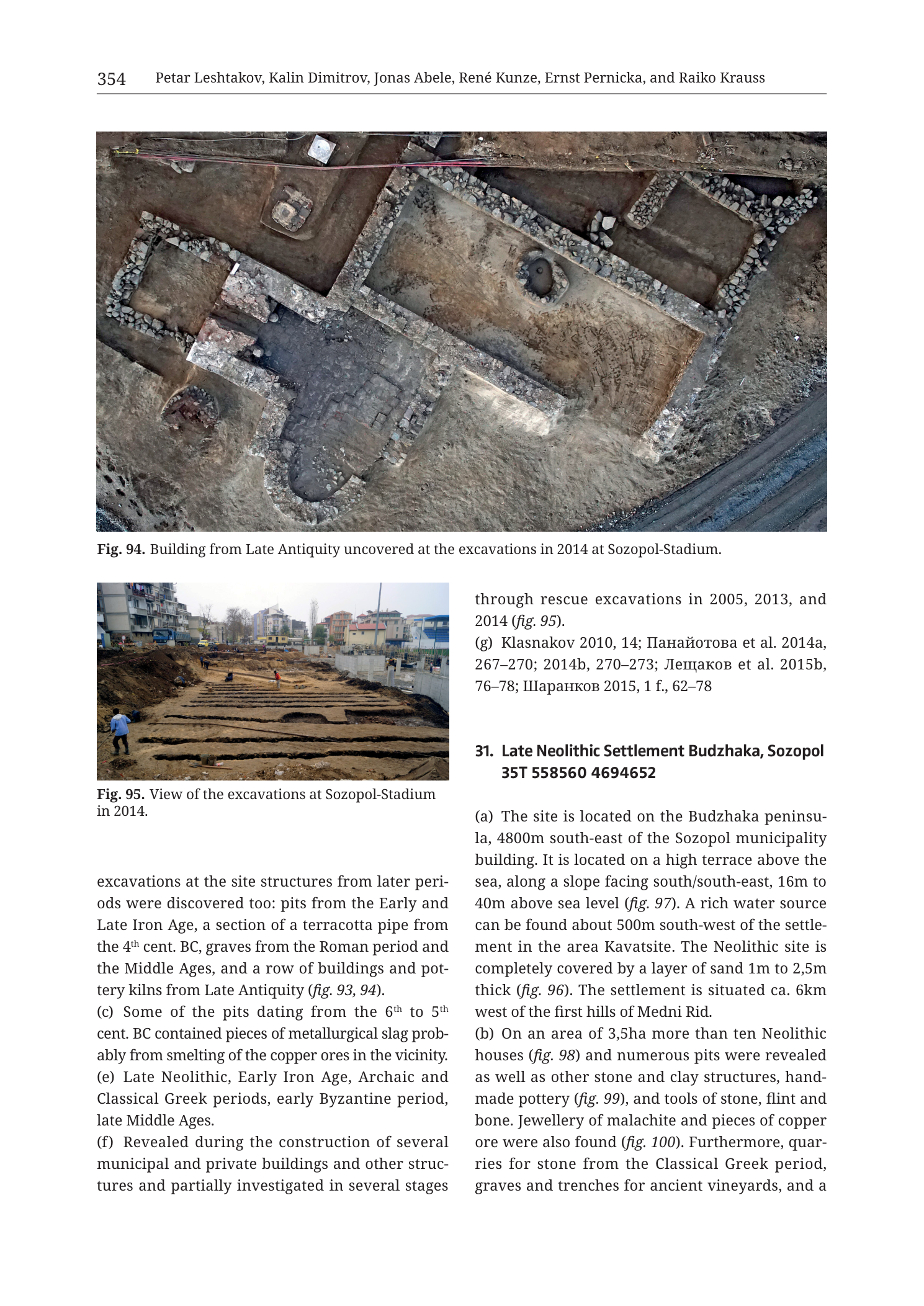
Caption: “Fig. 94. Building from Late Antiquity uncovered at the excavations in 2014 at Sozopol-Stadium.”
No text on the photograph itself.
Fig. 95 — Ground excavation photograph (middle-left)
Caption: “Fig. 95. View of the excavations at Sozopol-Stadium in 2014.”
No text on the photograph itself.
Body text — close of prior catalogue entry (Sozopol-Stadium / multi-period urban site; heading on previous page)
(Continues mid-sentence:)
“excavations at the site structures from later periods were discovered too: pits from the Early and Late Iron Age, a section of a terracotta pipe from the 4th cent. BC, graves from the Roman period and the Middle Ages, and a row of buildings and pottery kilns from Late Antiquity (fig. 93, 94).”
“(c) Some of the pits dating from the 6th to 5th cent. BC contained pieces of metallurgical slag probably from smelting of the copper ores in the vicinity.”
“(e) Late Neolithic, Early Iron Age, Archaic and Classical Greek periods, early Byzantine period, late Middle Ages.”
“(f) Revealed during the construction of several municipal and private buildings and other structures and partially investigated in several stages through rescue excavations in 2005, 2013, and 2014 (fig. 95).”
“(g) Klasnakov 2010, 14; Панайотова et al. 2014a, 267–270; 2014b, 270–273; Лещаков et al. 2015b, 76–78; Шаранков 2015, 1 f., 62–78.”
- Translation (selected surnames): Panayotova et al. 2014a/b; Leshtakov et al. 2015b; Sharankov 2015.
Entry 31 — Late Neolithic Settlement Budzhaka, Sozopol (partial)
Heading: “31. Late Neolithic Settlement Budzhaka, Sozopol 35T 558560 4694652”
“(a) The site is located on the Budzhaka peninsula, 4800m south-east of the Sozopol municipality building. It is located on a high terrace above the sea, along a slope facing south/south-east, 16m to 40m above sea level (fig. 97). A rich water source can be found about 500m south-west of the settlement in the area Kavatsite. The Neolithic site is completely covered by a layer of sand 1m to 2,5m thick (fig. 96). The settlement is situated ca. 6km west of the first hills of Medni Rid.”
“(b) On an area of 3,5ha more than ten Neolithic houses (fig. 98) and numerous pits were revealed as well as other stone and clay structures, handmade pottery (fig. 99), and tools of stone, flint and bone. Jewellery of malachite and pieces of copper ore were also found (fig. 100). Furthermore, quarries for stone from the Classical Greek period, graves and trenches for ancient vineyards, and a”
(text ends mid-sentence at page break.)
Description
TYPE & PURPOSE
Catalogue page closing a multi-period Sozopol-Stadium urban/rescue site (with Late Antique building and 2014 excavation views) and opening 31. Late Neolithic Settlement Budzhaka, Sozopol — a sand-covered coastal Neolithic settlement on the Budzhaka peninsula with houses, pits, handmade pottery, malachite jewellery, and copper ore.
Filename targets n31 Budzhaka; Figs. 94–95 belong to the preceding Sozopol-Stadium entry.
OVERALL PAGE LAYOUT
- Top full-width: Fig. 94 vertical aerial of Late Antique stone building plan.
- Below: two columns — left Fig. 95 + residual prior-entry prose; right prior-entry (f residual)/(g) + entry 31 start.
- Printed page 354.
- No coordinate-gridded map on this page.
Fig. 94 — LATE ANTIQUITY BUILDING, SOZOPOL-STADIUM 2014
- Vertical/high-oblique colour aerial photograph of excavated stone architecture.
- Multi-room rectangular building complex with stone wall footings; at least two major rectangular rooms side by side, plus adjoining spaces.
- Circular built feature (well, pit lining, or apsidal/installation) in one room sector.
- Darker occupation/fill patches inside rooms; lighter sand/sediment surrounds.
- Survey markers and a pink/red linear tape or cable along the top edge of the frame.
- Illustrates Late Antique buildings (and context for pottery kilns cited with fig. 93–94) at Sozopol-Stadium.
Fig. 95 — SOZOPOL-STADIUM EXCAVATIONS 2014, GROUND VIEW
- Colour ground-level photograph looking along a long excavation trench system in an urban setting.
- Multiple parallel baulks and excavated strips of brown earth; workers present (one in blue shirt left foreground; others mid-distance).
- Background: modern multi-storey apartment buildings, construction fencing, overcast sky.
- Documents the rescue-excavation setting amid municipal/private construction (field f).
PRIOR ENTRY CLOSE — SOZOPOL-STADIUM (MULTI-PERIOD)
From surviving text (heading previous page):
- Later-period structures: Early and Late Iron Age pits; terracotta pipe section 4th cent. BC; Roman and Medieval graves; Late Antiquity building row and pottery kilns (figs. 93, 94).
- (c) Some 6th–5th cent. BC pits contained metallurgical slag, probably from smelting copper ores in the vicinity — direct urban-Sozopol link to regional copper metallurgy.
- (e) Late Neolithic; Early Iron Age; Archaic and Classical Greek; early Byzantine; late Middle Ages.
- (f) Found during construction; rescue excavations 2005, 2013, 2014 (fig. 95).
- (g) Bibliography as transcribed above.
ENTRY 31 — LATE NEOLITHIC SETTLEMENT BUDZHAKA (PARTIAL)
- Centroid: 35T 558560 4694652
- (a) Location / setting:
- Budzhaka peninsula;
- 4800 m SE of Sozopol municipality building;
- high terrace above the sea; slope facing S/SE;
- 16–40 m a.s.l. (fig. 97 — not on this page);
- rich water source ~500 m SW at Kavatsite;
- Neolithic site sealed under 1–2.5 m of sand (fig. 96 — not on this page);
- ca. 6 km west of the first hills of Medni Rid.
- (b) Excavated content (as far as printed):
- area 3.5 ha;
- more than ten Neolithic houses (fig. 98);
- numerous pits; other stone and clay structures;
- handmade pottery (fig. 99);
- tools of stone, flint, and bone;
- jewellery of malachite and pieces of copper ore (fig. 100);
- also Classical Greek stone quarries; graves; ancient vineyard trenches; and a… [cuts off].
SPATIAL RELATIONSHIPS (PAGE-LEVEL)
- Budzhaka is a coastal Sozopol-peninsula Neolithic settlement under thick sand, facing the sea, ~6 km west of Medni Rid’s first hills — i.e. on the seaward side of the research area, opposite the inland mine ridge but within copper-ore and malachite-jewellery find distance of the metalliferous zone.
- Malachite jewellery + copper ore at a Late Neolithic house-and-pit settlement make Budzhaka a key early consumer/workshop node complementary to Akladi Cheiri’s metallurgical structures and the ridge mines.
- Sozopol-Stadium (closing entry) supplies an urban multi-period sequence in Sozopol proper, including Archaic/Classical pits with copper-smelting slag — later-period metallurgy in the same municipality as Budzhaka’s Neolithic copper/malachite finds.
- UTM easting 558560 is among the easternmost catalogue centroids in this batch (coastal Sozopol peninsula), with northing ~4694652 still in valid 35T SE-Bulgaria range.
RELATIONSHIP TO OTHER FIGURES
- Prior entry → figs. 93–95 (94–95 on this page; 93 not here).
- Entry 31 (a) → figs. 96–97; (b) → figs. 98–100 (none of 96–100 on this page).
- Filename n31 Budzhaka; excavation photos on the plate are Sozopol-Stadium.
Consistency Check
- No coordinate-gridded map on this page → N/A.
- Budzhaka centroid 35T 558560 4694652: within expected SE-Bulgaria 35T ranges (easting near upper coastal values ~530–560k).
- Result: N/A (no map axes).
Notes
- Filename p356 vs printed 354 — collection offset; printed page authoritative.
- Decimal commas in source text (3,5ha; 2,5m) retained as European notation = 3.5 ha and 2.5 m.
- Entry 31 truncated mid-(b); dating fields (e)–(g) and house/find figures not on this image.
- Prior entry’s catalogue number/name not printed on this page remnant; identified as Sozopol-Stadium from figure captions.
- None further.