Description
Transcription
Page header
- Page number (top-left): 350
- Header: “Petar Leshtakov, Kalin Dimitrov, Jonas Abele, René Kunze, Ernst Pernicka, and Raiko Krauss”
Fig. 77 — Contour location map (upper-left)
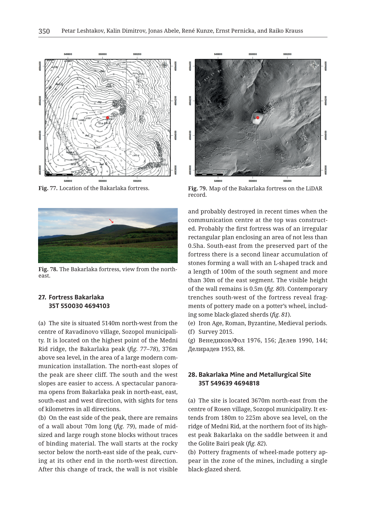
Caption: “Fig. 77. Location of the Bakarlaka fortress.”
Coordinate grid labels:
- Easting (top/bottom, left → right): 549800 | 550000 | 550200
- Northing (left/right, top → bottom): 4694400 | 4694200 | 4694000 | 4693800
Other map elements:
- Dense brown topographic contours defining a prominent peak; spot height / elevation labels include 376.7 near the summit area and other contour numerals (e.g. values in the 300s on flanks).
- Red filled circle on the summit plateau — fortress site marker.
- Tracks/paths dashed on the slopes.
- North arrow / compass rose: upper-right.
- Scale context from companion Fig. 79 bar (150 m); Fig. 77 shows the same peak massif at comparable large scale (grid 200 m easting, 200 m northing).
Fig. 78 — Landscape photograph (middle-left)
Caption: “Fig. 78. The Bakarlaka fortress, view from the north-east.”
Overprinted: red arrow pointing down to the summit of the wooded peak.
No other text on the photograph.
Fig. 79 — LiDAR map (upper-right)
Caption: “Fig. 79. Map of the Bakarlaka fortress on the LiDAR record.”
Coordinate grid labels:
- Easting (top/bottom, left → right): 549800 | 550000 | 550200
- Northing (left/right, top → bottom): 4694400 | 4694200 | 4694000 | 4693800
Other map elements:
- Greyscale LiDAR hillshade/DSM of the peak and surrounding slopes.
- Red filled circle on a light rectangular patch at the summit — modern communication installation platform / cleared summit area coinciding with the fortress locus.
- Steep NE cliff morphology visible as tight hillshade gradients; gentler S and W approaches.
- North arrow / compass rose: upper-right.
- Scale bar (lower-left): labelled “150 m”.
Entry 27 — Fortress Bakarlaka
Heading: “27. Fortress Bakarlaka 35T 550030 4694103”
“(a) The site is situated 5140m north-west from the centre of Ravadinovo village, Sozopol municipality. It is located on the highest point of the Medni Rid ridge, the Bakarlaka peak (fig. 77–78), 376m above sea level, in the area of a large modern communication installation. The north-east slopes of the peak are sheer cliff. The south and the west slopes are easier to access. A spectacular panorama opens from Bakarlaka peak in north-east, east, south-east and west direction, with sights for tens of kilometres in all directions.”
“(b) On the east side of the peak, there are remains of a wall about 70m long (fig. 79), made of mid-sized and large rough stone blocks without traces of binding material. The wall starts at the rocky sector below the north-east side of the peak, curving at its other end in the north-west direction. After this change of track, the wall is not visible”
(continues right column:)
“and probably destroyed in recent times when the communication centre at the top was constructed. Probably the first fortress was of an irregular rectangular plan enclosing an area of not less than 0.5ha. South-east from the preserved part of the fortress there is a second linear accumulation of stones forming a wall with an L-shaped track and a length of 100m of the south segment and more than 30m of the east segment. The visible height of the wall remains is 0.5m (fig. 80). Contemporary trenches south-west of the fortress reveal fragments of pottery made on a potter’s wheel, including some black-glazed sherds (fig. 81).”
“(e) Iron Age, Roman, Byzantine, Medieval periods.”
“(f) Survey 2015.”
“(g) Венедиков/Фол 1976, 156; Делев 1990, 144; Делирадев 1953, 88.”
- Translation (bibliographic surnames): Venedikov/Fol 1976; Delev 1990; Deliradev 1953.
(Note: fields (c)(d) not printed for entry 27.)
Entry 28 — Bakarlaka Mine and Metallurgical Site (start only)
Heading: “28. Bakarlaka Mine and Metallurgical Site 35T 549639 4694818”
“(a) The site is located 3670m north-east from the centre of Rosen village, Sozopol municipality. It extends from 180m to 225m above sea level, on the ridge of Medni Rid, at the northern foot of its highest peak Bakarlaka on the saddle between it and the Golite Bairi peak (fig. 82).”
“(b) Pottery fragments of wheel-made pottery appear in the zone of the mines, including a single black-glazed sherd.”
(Remainder of entry 28 continues off-page.)
Description
TYPE & PURPOSE
Catalogue plate for 27. Fortress Bakarlaka — the fortification on Medni Rid’s highest peak (376 m) — with contour map, landscape view, and LiDAR summit map; and the opening of 28. Bakarlaka Mine and Metallurgical Site on the saddle north of the peak toward Golite Bairi.
Bakarlaka is both a toponym for the peak/fortress and, in the wider Rosen-field literature, an alternate name strand for the Meden Rid deposit area; here entry 27 is the fortress and entry 28 the mine/metallurgical scatter on the northern foot/saddle.
OVERALL PAGE LAYOUT
- Upper pair: Fig. 77 contour map (left) and Fig. 79 LiDAR (right) — same peak, dual visualisation.
- Mid-left: Fig. 78 photo from NE with red summit arrow.
- Text: entry 27 across both columns; entry 28 starts lower-right.
- Printed page 350.
Fig. 77 — BAKARLAKA FORTRESS LOCATION (CONTOURS)
Type. Large-scale topographic contour map of Bakarlaka peak.
Grid / scale / orientation.
- Easting 549800–550200 = 400 m; northing 4693800–4694400 = 600 m.
- North up; compass rose upper-right.
- Summit spot height ~376.7 m labelled near the red site dot — matches body text 376 m a.s.l.
Relief.
- Tight concentric contours define a sharp peak; NE side shows cliff-like contour packing; S and W sides more open — matching text on sheer NE cliffs vs easier S/W access.
- Red dot on the summit flat/platform.
Fig. 78 — BAKARLAKA FROM THE NORTH-EAST
- Colour landscape photograph across green pasture toward a wooded ridge culminating in Bakarlaka peak.
- Red arrow marks the summit (fortress / communication mast area).
- Cloudy sky; rolling foreground fields; forested slopes.
- Conveys the peak’s isolation and long-range visual command described in (a).
Fig. 79 — BAKARLAKA FORTRESS ON LiDAR
Type. LiDAR hillshade/DSM of the same peak window as Fig. 77.
Grid / scale.
- Same labelled bounds: E 549800–550200, N 4693800–4694400.
- Scale bar 150 m.
Features.
- Summit shows a light rectangular cleared pad with red marker — modern communication installation obliterating/occupying the fortress core (as text states).
- Hillshade picks out cliff breaks on the NE and the broader ridge shoulders.
- Wall traces of dry-stone fortress fabric are subtle on LiDAR at this contrast; the map primarily locates the summit installation and micro-relief of the peak rather than drafting individual wall polylines.
ENTRY 27 — FORTRESS BAKARLAKA
- Centroid: 35T 550030 4694103
- (a) 5140 m NW of Ravadinovo centre, Sozopol municipality; highest point of Medni Rid = Bakarlaka peak (figs. 77–78); 376 m a.s.l.; large modern communication installation on site; NE slopes sheer cliff; S and W easier access; panorama tens of km NE, E, SE, W.
- (b) E-side wall remains ~70 m long (fig. 79), mid-to-large rough stone blocks, no binding material; starts at rocky sector below NE peak side, curves NW; beyond bend wall lost — probably destroyed by modern communication centre. First fortress probably irregular rectangular plan, area ≥0.5 ha. SE of preserved fortress: second linear stone accumulation = L-shaped wall, S segment 100 m, E segment >30 m, visible height 0.5 m (fig. 80). Modern trenches SW of fortress: wheel-made pottery including black-glazed sherds (fig. 81).
- (e) Iron Age, Roman, Byzantine, Medieval periods.
- (f) Survey 2015.
- (g) Венедиков/Фол 1976, 156; Делев 1990, 144; Делирадев 1953, 88.
ENTRY 28 START — BAKARLAKA MINE AND METALLURGICAL SITE
- Centroid: 35T 549639 4694818
- (a) 3670 m NE of Rosen village centre, Sozopol municipality; 180–225 m a.s.l.; Medni Rid ridge at northern foot of Bakarlaka peak on the saddle between Bakarlaka and Golite Bairi peak (fig. 82 — not on this page).
- (b) Wheel-made pottery in the mine zone, including one black-glazed sherd.
- Remainder off-page.
SPATIAL RELATIONSHIPS (PAGE-LEVEL)
- Fortress Bakarlaka crowns the absolute high point of Medni Rid (376 m), with dry-stone walls and multi-period use (Iron Age through Medieval), heavily impacted by a modern communication pad visible on LiDAR.
- Mine/metallurgical site (28) lies on the lower northern foot/saddle (180–225 m), centroid ~700 m north and slightly west of the fortress centroid (N 4694818 vs 4694103; E 549639 vs 550030) — extraction/processing below the fortified peak, toward Golite Bairi.
- Bakarlaka peak’s NE cliff and long views make it a classic ridge-top control point over the Rosen ore field and coastal plain.
- Shared black-glazed pottery at fortress trenches and mine zone hints at chronological overlap (Classical/Hellenistic–Roman ceramic horizon) between fortified and extractive loci.
RELATIONSHIP TO OTHER FIGURES
- Entry 27 (a) → figs. 77–78; (b) → fig. 79, and figs. 80–81 (not on this page).
- Entry 28 (a) → fig. 82 (not on this page).
- Dual map pair (contours + LiDAR) mirrors the Rosen/Kyumyurlaka documentation style used earlier in the catalogue.
Consistency Check
Fig. 77 vs centroid 35T 550030 4694103:
- Bounds: Easting [549800–550200], Northing [4693800–4694400]
- Easting PASS; Northing PASS
- Result: PASS
Fig. 79 vs same centroid:
- Same labelled bounds as Fig. 77
- Result: PASS
Entry 28 centroid 35T 549639 4694818 lies north of both map windows (4694818 > 4694400) — correct (different site, not on these summit maps).
Notes
- Filename p352 vs printed 350 — collection offset; printed page authoritative.
- Entry 27 omits (c)(d) as printed.
- Fig. 77 scale bar numerals are small; ground extent secured from 400×600 m grid window; Fig. 79 explicitly labels 150 m bar.
- Summit elevation 376 m in text vs ~376.7 contour/spot label on map — consistent.
- “Bakarlaka” fortress vs “Meden Rid/Bakarlak” deposit naming in geological literature: this page’s entry 28 is the catalogue’s mine identity at the peak’s northern foot; do not collapse fortress and deposit without cross-checking other plates.
- None further.