Description
Transcription
Page header
- Page number (top-left): 348
- Header: “Petar Leshtakov, Kalin Dimitrov, Jonas Abele, René Kunze, Ernst Pernicka, and Raiko Krauss”
Fig. 70 — Topographic location map (upper-left)
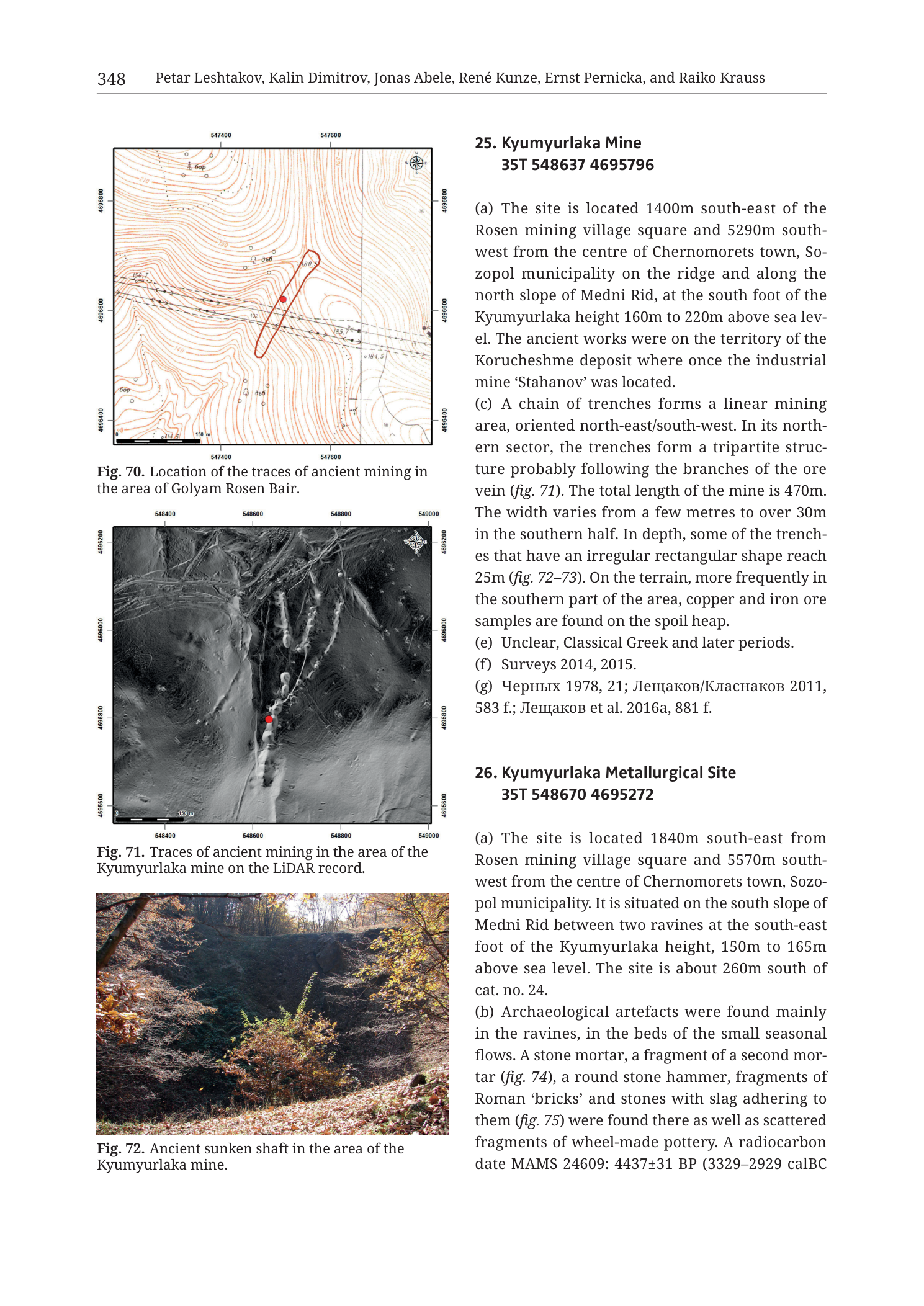
Caption: “Fig. 70. Location of the traces of ancient mining in the area of Golyam Rosen Bair.”
Coordinate grid labels:
- Top/bottom Easting (left → right): 547400 | 547600
- Left/right Northing (top → bottom): 4696800 | 4696600 | 4696400
(Additional intermediate ticks may exist; labelled values as above are clearly printed.)
Other map elements:
- Brown topographic contours with elevation labels (including among readable values: 150, 160, 180, 184.5, and other small contour numerals).
- Red elongated oval outline trending roughly NE–SW, enclosing the mining-trace corridor; red filled circle inside the oval (site marker).
- Road/track lines dashed and solid across the hill.
- North arrow / compass rose: upper-right inside frame.
- Scale bar (lower-left): labelled “150 m”.
Fig. 71 — LiDAR map (middle-left)
Caption: “Fig. 71. Traces of ancient mining in the area of the Kyumyurlaka mine on the LiDAR record.”
Coordinate grid labels:
- Top/bottom Easting (left → right): 548400 | 548600 | 548800 | 549000
- Left/right Northing (top → bottom): 4696200 | 4696000 | 4695800 | 4695600
Other map elements:
- Greyscale LiDAR hillshade/DSM.
- Red filled circle near centre-south of the bright linear mining corridor.
- Multiple parallel/subparallel linear trenches and pit chains trending roughly N–S to NNE–SSW, coalescing into a multi-strand mining scar; northern sector shows branching/tripartite trench structure.
- Spoil/heap topography flanking the cuts.
- North arrow / compass rose: upper-right.
- Scale bar (lower-left): labelled “150 m”.
Fig. 72 — Photograph (lower-left)
Caption: “Fig. 72. Ancient sunken shaft in the area of the Kyumyurlaka mine.”
No text on the photograph itself.
Entry 25 — Kyumyurlaka Mine (complete on this page except field b absent)
Heading: “25. Kyumyurlaka Mine 35T 548637 4695796”
“(a) The site is located 1400m south-east of the Rosen mining village square and 5290m south-west from the centre of Chernomorets town, Sozopol municipality on the ridge and along the north slope of Medni Rid, at the south foot of the Kyumyurlaka height 160m to 220m above sea level. The ancient works were on the territory of the Korucheshme deposit where once the industrial mine ‘Stahanov’ was located.”
“(c) A chain of trenches forms a linear mining area, oriented north-east/south-west. In its northern sector, the trenches form a tripartite structure probably following the branches of the ore vein (fig. 71). The total length of the mine is 470m. The width varies from a few metres to over 30m in the southern half. In depth, some of the trenches that have an irregular rectangular shape reach 25m (fig. 72–73). On the terrain, more frequently in the southern part of the area, copper and iron ore samples are found on the spoil heap.”
“(e) Unclear, Classical Greek and later periods.”
“(f) Surveys 2014, 2015.”
“(g) Черных 1978, 21; Лещаков/Класнаков 2011, 583 f.; Лещаков et al. 2016a, 881 f.”
- Translation (bibliographic surnames): Chernykh 1978; Leshtakov/Klasnakov 2011; Leshtakov et al. 2016a.
(Note: field (b) and (d) not printed for entry 25 on this page.)
Entry 26 — Kyumyurlaka Metallurgical Site (partial)
Heading: “26. Kyumyurlaka Metallurgical Site 35T 548670 4695272”
“(a) The site is located 1840m south-east from Rosen mining village square and 5570m south-west from the centre of Chernomorets town, Sozopol municipality. It is situated on the south slope of Medni Rid between two ravines at the south-east foot of the Kyumyurlaka height, 150m to 165m above sea level. The site is about 260m south of cat. no. 24.”
“(b) Archaeological artefacts were found mainly in the ravines, in the beds of the small seasonal flows. A stone mortar, a fragment of a second mortar (fig. 74), a round stone hammer, fragments of Roman ‘bricks’ and stones with slag adhering to them (fig. 75) were found there as well as scattered fragments of wheel-made pottery. A radiocarbon date MAMS 24609: 4437±31 BP (3329–2929 calBC”
(text ends mid-parenthesis/sentence at page break; remainder not in this PNG.)
Description
TYPE & PURPOSE
Catalogue plate presenting:
- Fig. 70 — contour location map of Golyam Rosen Bair ancient mining traces (completing entry 24’s fig citations from the previous page);
- full catalogue entry 25. Kyumyurlaka Mine with LiDAR (Fig. 71) and shaft photograph (Fig. 72);
- opening of 26. Kyumyurlaka Metallurgical Site.
Filename targets n25–26 Kyumyurlaka mine and metallurgical pair — the Korucheshme / former ‘Stahanov’ industrial-mine ground on Medni Rid, one of the five classic Rosen-field deposits (Korucheshme = Kyumyurlaka in the broader literature).
OVERALL PAGE LAYOUT
- Left column stacked figures: Fig. 70 map, Fig. 71 LiDAR, Fig. 72 photo.
- Right column: entry 25 full; entry 26 start through mid-radiocarbon citation.
- Printed page 348.
Fig. 70 — GOLYAM ROSEN BAIR MINING TRACES (TOPOGRAPHIC MAP)
Type. Large-scale contour location map of the NE–SW pit chain at Golyam Rosen Bair.
Frame / grid / scale.
- Square frame; north up (compass rose upper-right).
- Easting labels 547400, 547600 (200 m); northing 4696800, 4696600, 4696400 (200 m).
- Approximate ground window: ~200+ m E–W (if only two easting labels span the frame to neatlines beyond ticks, still a few hundred metres) by 400 m N–S.
- Scale bar 150 m.
Relief.
- Dense brown contours define a hill/ridge; readable elevations ~150–184.5 m and higher labels on upper slopes — matches entry 24’s 150–180 m a.s.l. range.
Annotations.
- Red NE–SW oval + central red dot mark the aligned pits of entry 24 (c) (~200 m long).
- Tracks/roads cross the hillside.
Role. Fulfils the fig. 70 cross-reference from entry 24 on the previous page.
Fig. 71 — KYUMYURLAKA MINE ON LiDAR
Type. Greyscale LiDAR hillshade/DSM of the Kyumyurlaka ancient mine trench system.
Frame / grid / scale.
- Square frame; north up.
- Easting 548400–549000 = 600 m; northing 4695600–4696200 = 600 m.
- Scale bar 150 m.
Mining morphology on LiDAR.
- Bright/high-contrast linear scars form a multi-strand trench chain along a NE–SW to N–S corridor.
- Northern sector shows branching into multiple parallel cuts — the “tripartite structure probably following the branches of the ore vein” of entry 25 (c).
- Southern half shows wider disturbed ground and spoil.
- Red point marks the catalogue centroid area on the main trench line.
- Total mapped scar length on the DSM is consistent with the stated 470 m mine length (long axis spans a large fraction of the 600 m northing window).
Fig. 72 — ANCIENT SUNKEN SHAFT, KYUMYURLAKA
- Colour photograph of a deep, steep-sided open cut / sunken shaft or rectangular trench in woodland.
- Dark shadowed interior of the pit; autumn foliage (brown/orange leaves) on surrounding slopes and trees.
- Walls appear near-vertical in places; depth is clearly multiple metres — supports text claim that some irregular rectangular trenches reach 25 m depth (with fig. 73, not on this page, as companion).
- No scale bar or people in frame; depth is qualitative from the photo alone.
ENTRY 25 — KYUMYURLAKA MINE
- Centroid: 35T 548637 4695796
- (a) 1400 m SE of Rosen mining village square; 5290 m SW of Chernomorets; on ridge and N slope of Medni Rid at S foot of Kyumyurlaka height; 160–220 m a.s.l.; ancient works on Korucheshme deposit territory, former industrial mine ‘Stahanov’.
- (c) Linear NE–SW trench chain; northern tripartite branching along vein branches (fig. 71); total length 470 m; width few metres to >30 m (southern half); some irregular rectangular trenches to 25 m depth (figs. 72–73); Cu and Fe ore samples on spoil heaps, especially south.
- (e) Unclear, Classical Greek and later periods.
- (f) Surveys 2014, 2015.
- (g) Черных 1978, 21; Лещаков/Класнаков 2011, 583 f.; Лещаков et al. 2016a, 881 f.
- Fields (b)(d) not printed.
ENTRY 26 — KYUMYURLAKA METALLURGICAL SITE (PARTIAL)
- Centroid: 35T 548670 4695272
- (a) 1840 m SE of Rosen village square; 5570 m SW of Chernomorets; S slope of Medni Rid between two ravines at SE foot of Kyumyurlaka height; 150–165 m a.s.l.; about 260 m south of cat. no. 24 (printed — see Notes on numbering).
- (b) Finds mainly in ravines/seasonal stream beds: stone mortar; fragment of second mortar (fig. 74); round stone hammer; Roman ‘brick’ fragments; stones with adhering slag (fig. 75); scattered wheel-made pottery; radiocarbon MAMS 24609: 4437±31 BP (3329–2929 calBC … [cuts off].
SPATIAL RELATIONSHIPS (PAGE-LEVEL)
- Kyumyurlaka Mine (25) is the long (470 m), deep (to 25 m), NE–SW multi-strand opencast on the Korucheshme / Stahanov ground — i.e. the catalogue identity of the Korucheshme deposit in the NW→SE Rosen-field chain (Rosen – Korucheshme – Meden Rid – Sarneshko Kladenche – Propadnala Voda).
- LiDAR shows vein-branch control (tripartite north) and broad southern spoil — classic ridge-crest vein mining morphology on Medni Rid.
- Metallurgical site (26) sits ~500 m south of the mine centroid by northing (4695796 → 4695272) at slightly lower elevation (150–165 vs 160–220 m), in ravines on the south slope — downslope processing locus relative to the extraction trenches.
- Golyam Rosen Bair (Fig. 70) remains the next ridge sector west (~5475xx E vs Kyumyurlaka ~5486xx E), same NE–SW structural grain.
- Printed “260 m south of cat. no. 24” for entry 26 may intend cat. no. 25 (the mine just above) or another cross-ref; centroids of 25 and 26 differ by ~524 m in northing — report printed text as is.
RELATIONSHIP TO OTHER FIGURES
- Entry 24 (prior) → fig. 70 (this page).
- Entry 25 (c) → fig. 71, figs. 72–73 (73 not on this page).
- Entry 26 (b) → figs. 74–75 (not on this page).
- Industrial name ‘Stahanov’ links to modern mining history overlays on the same deposit.
Consistency Check
Fig. 70 vs entry 24 centroid (prior page) 35T 547514 4696620:
- Map bounds as labelled: Easting [547400–547600], Northing [4696400–4696800]
- Easting: 547400 ≤ 547514 ≤ 547600 → PASS
- Northing: 4696400 ≤ 4696620 ≤ 4696800 → PASS
- Result: PASS
Fig. 71 vs entry 25 centroid 35T 548637 4695796:
- Map bounds: Easting [548400–549000], Northing [4695600–4696200]
- Easting: 548400 ≤ 548637 ≤ 549000 → PASS
- Northing: 4695600 ≤ 4695796 ≤ 4696200 → PASS
- Result: PASS
Entry 26 centroid 35T 548670 4695272 lies south of Fig. 71’s southern neatline (4695272 < 4695600) — expected if the metallurgical site is a separate downslope locus not mapped on Fig. 71.
Notes
- Filename p350 vs printed 348 — collection offset; printed page authoritative.
- Entry 25 omits (b) and (d) as printed.
- Entry 26 truncated mid-radiocarbon calibration parenthesis; second date/fields continue off-page.
- Entry 26 (a) “about 260m south of cat. no. 24” is transcribed as printed; spatial sense may better match cat. no. 25 — unresolved on this page.
- Fig. 70 easting may extend slightly past labelled 547400–547600 neatline ticks; centroid still passes on labelled bounds.
- ‘Stahanov’ / Korucheshme synonymy is stated in the text and matches Tzankova-field naming used elsewhere in the collection.
- None further.