Description
Transcription
Page header
- Header (centred top): “Catalogue of Investigated Archaeological Sites and Mining Places”
- Page number (top-right): 347
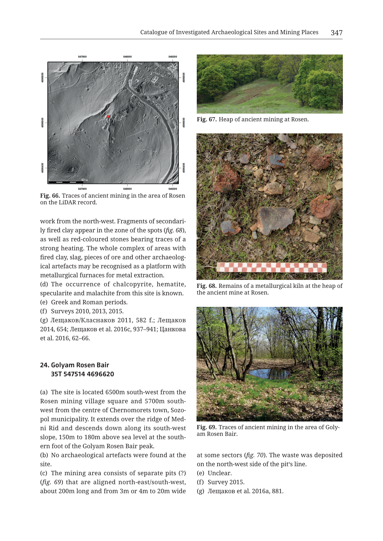
Fig. 66 — LiDAR map (upper-left)
Caption: “Fig. 66. Traces of ancient mining in the area of Rosen on the LiDAR record.”
Coordinate grid labels (UTM-style metre ticks):
- Top edge (Easting, left → right): 547800 | 548000 | 548200
- Bottom edge (Easting, left → right): 547800 | 548000 | 548200
- Left/right edges (Northing, top → bottom): 4696600 | 4696500 | 4696400
Other map elements:
- Greyscale LiDAR hillshade / DSM relief base.
- Red filled circle near centre-left of the illuminated slope — site marker for the Rosen ancient-mine locus.
- Linear dark depression / trench feature trending roughly NE–SW through the marked area (opencast/ravine trace).
- Road corridor visible as a pale linear feature along the lower-right / eastern side of the frame (asphalt road of entry 23a).
- Built structures / roof footprints visible in the NE sector (Rosen mining-village / administrative fabric).
- North arrow / compass rose: upper-right inside frame.
- Scale bar (lower-left inside frame): labelled “150 m”.
Fig. 67 — Photograph (upper-right)
Caption: “Fig. 67. Heap of ancient mining at Rosen.”
No text on the photograph itself.
Fig. 68 — Photograph (middle-right)
Caption: “Fig. 68. Remains of a metallurgical kiln at the heap of the ancient mine at Rosen.”
Scale bar in photo: red-and-white chequered ranging bar along the bottom of the image (standard archaeological photo scale; individual metre/centimetre ticks not numerically labelled beyond the bar itself).
No other text on the photograph.
Fig. 69 — Photograph (lower-right)
Caption: “Fig. 69. Traces of ancient mining in the area of Golyam Rosen Bair.”
No text on the photograph itself.
Body text — end of entry 23 (Mine and Metallurgical Site Rosen)
(Continues mid-sentence from previous page:)
“work from the north-west. Fragments of secondarily fired clay appear in the zone of the spots (fig. 68), as well as red-coloured stones bearing traces of a strong heating. The whole complex of areas with fired clay, slag, pieces of ore and other archaeological artefacts may be recognised as a platform with metallurgical furnaces for metal extraction.”
“(d) The occurrence of chalcopyrite, hematite, specularite and malachite from this site is known.”
“(e) Greek and Roman periods.”
“(f) Surveys 2010, 2013, 2015.”
“(g) Лещаков/Класнаков 2011, 582 f.; Лещаков 2014, 654; Лещаков et al. 2016c, 937–941; Цанкова et al. 2016, 62–66.”
- Translation (bibliographic surnames): Leshtakov/Klasnakov 2011; Leshtakov 2014; Leshtakov et al. 2016c; Tsankova et al. 2016.
Entry 24 — Golyam Rosen Bair (complete on this page)
Heading: “24. Golyam Rosen Bair 35T 547514 4696620”
“(a) The site is located 6500m south-west from the Rosen mining village square and 5700m south-west from the centre of Chernomorets town, Sozopol municipality. It extends over the ridge of Medni Rid and descends down along its south-west slope, 150m to 180m above sea level at the southern foot of the Golyam Rosen Bair peak.”
“(b) No archaeological artefacts were found at the site.”
“(c) The mining area consists of separate pits (?) (fig. 69) that are aligned north-east/south-west, about 200m long and from 3m or 4m to 20m wide at some sectors (fig. 70). The waste was deposited on the north-west side of the pit’s line.”
“(e) Unclear.”
“(f) Survey 2015.”
“(g) Лещаков et al. 2016a, 881.”
- Translation: Leshtakov et al. 2016a, 881.
(Note: field (d) not printed for entry 24.)
Description
TYPE & PURPOSE
Catalogue page completing 23. Mine and Metallurgical Site Rosen with LiDAR visualisation of the opencast, photographs of the ancient spoil heap and metallurgical kiln remains, mineral list, dating, and bibliography; and presenting the full short entry 24. Golyam Rosen Bair with a photograph of its pit-chain mining traces.
Filename targets n24 Golyam Rosen Bair; the page is equally the evidentiary climax of the Rosen mine entry (furnaces platform interpretation, ore mineralogy, Greek–Roman dating).
OVERALL PAGE LAYOUT
- Left column: Fig. 66 LiDAR map + caption; end of entry 23 (c residual through g); entry 24 heading through (c) start.
- Right column: Fig. 67; Fig. 68; Fig. 69; end of entry 24 (c residual through g).
- Printed page 347.
Fig. 66 — LiDAR TRACES OF ANCIENT MINING AT ROSEN
Type & purpose. Greyscale LiDAR hillshade/DSM map showing micro-relief of the Rosen ancient opencast and adjacent modern infrastructure; red point marks the catalogue site.
Frame, extent, orientation.
- Square map frame; north arrow upper-right; north up.
- Easting span 547800–548200 = 400 m.
- Northing span 4696400–4696600 = 200 m.
- Ground window ~400 m E–W by ~200 m N–S.
Scale.
- Scale bar 150 m (lower-left).
- No ratio scale printed.
Coordinates / grid.
- Easting: 547800, 548000, 548200 (200 m).
- Northing: 4696600, 4696500, 4696400 (100 m labelled).
- Zone from catalogue heading: 35T.
Relief & physiography (LiDAR).
- Hillshade reveals a sloping hillside descending generally toward one side of the frame, dissected by a prominent linear depression (the opencast/ravine) running NE–SW through the site marker.
- Micro-topography of heaps, cuts, and road embankments is visible as tone contrasts on the DSM.
- No contour lines; relief is purely hillshade-derived.
Anthropogenic features.
- Red centroid marker on/beside the linear cut.
- Asphalt/modern road as a smooth linear ribbon along the eastern map sector — matches entry 23 (a) road through lower site sector.
- Building footprints in the NE — Rosen mine administrative/village fabric toward which the opencast was said to extend.
- Linear mining cut = the NE–SW opencast of entry 23 (c) (~90 m visible segment within broader >250 m estimated original length).
Spatial reading.
- Ancient mine trace is the dark linear trench; spoil/heap topography flanks it; modern road and buildings constrain the lower/NE end — matching the prose that 20th-century cover and modern mine infrastructure affect visibility and that workings continued NE to administrative buildings.
Fig. 67 — HEAP OF ANCIENT MINING AT ROSEN
- Colour photograph of a grass-covered earthen heap/mound on a hillside.
- Heap rises as a smooth green lobe, flanked and crowned by deciduous trees in leaf.
- Open grassy foreground; wooded background.
- Illustrates the NW heap of entry 23 where eight red fired-clay areas (~1000 m² total) were mapped (prior page) and where Fig. 68 kiln remains were photographed.
Fig. 68 — METALLURGICAL KILN REMAINS AT ROSEN HEAP
- Close-up colour ground photograph of fire-reddened clay lumps, heat-altered stones, and dark slaggy/stony fragments lying on a grassy/earthy surface.
- Several fist-to-cobble-sized pieces show strong red oxidation (secondarily fired clay / heated stone) and grey-dark metallic or slaggy surfaces.
- Red-and-white chequered scale bar along the bottom edge for size reference.
- Directly supports closing text of entry 23 (c): fragments of secondarily fired clay and red-coloured stones with strong heating; interpretation of the complex as a platform with metallurgical furnaces for metal extraction.
Fig. 69 — ANCIENT MINING TRACES, GOLYAM ROSEN BAIR
- Colour photograph inside open woodland.
- A linear water-filled depression / pit (ponded trench) runs through the mid-ground among tree trunks and leaf litter — surface expression of the NE–SW pit alignment of entry 24 (c).
- Green understorey and spring foliage.
- No people or tools visible.
ENTRY 23 CLOSE — MINE AND METALLURGICAL SITE ROSEN
Completing prior page’s mid-sentence on the fired-clay zones:
- Fired-clay spot zone also yields secondarily fired clay fragments (fig. 68) and red heat-affected stones.
- Whole complex (fired clay, slag, ore, other artefacts) recognised as a platform with metallurgical furnaces for metal extraction.
- (d) Minerals known from site: chalcopyrite, hematite, specularite, malachite.
- (e) Dating: Greek and Roman periods.
- (f) Surveys: 2010, 2013, 2015.
- (g) Bibliography: Лещаков/Класнаков 2011, 582 f.; Лещаков 2014, 654; Лещаков et al. 2016c, 937–941; Цанкова et al. 2016, 62–66.
Together with prior page: Rosen is a NE–SW vein-following opencast with adjacent heap-hosted furnace platform, secondary and primary Cu-Fe minerals, Greek–Roman date bracket, and LiDAR-visible trench morphology beside modern Rosen mine infrastructure.
ENTRY 24 — GOLYAM ROSEN BAIR (COMPLETE)
- Centroid: 35T 547514 4696620
- (a) Location: 6500 m SW of Rosen mining village square; 5700 m SW of Chernomorets centre, Sozopol municipality; extends over Medni Rid ridge and down the SW slope; 150–180 m a.s.l. at the southern foot of Golyam Rosen Bair peak.
- (b) No archaeological artefacts found.
- (c) Mining area = separate pits (?) aligned NE–SW; about 200 m long; width from 3–4 m to 20 m in places (fig. 70 — not on this page); waste deposited on the NW side of the pit line; illustrated in part by fig. 69.
- (e) Unclear.
- (f) Survey 2015.
- (g) Лещаков et al. 2016a, 881.
- Field (d) not printed.
Note on distances in (a): printed “6500m south-west from the Rosen mining village square” is a large offset relative to entry 23’s 420 m from the same square; Golyam Rosen Bair as a peak/ridge locus may be referenced to a different point along an extended working, or the figure may encode a specific sector — report the printed values as given. Centroid easting 547514 is only ~400 m west of Rosen site 547915, which fits a nearby ridge position better than a literal 6.5 km separation — flag in Notes.
SPATIAL RELATIONSHIPS (PAGE-LEVEL)
- Rosen (23) and Golyam Rosen Bair (24) share the same Medni Rid / Golyam Rosen Bair massif: entry 23 is on the steep N/NE foot-slope SE of the height; entry 24 runs along the ridge and SW slope at higher elevation (150–180 m vs 98–140 m).
- Both show NE–SW linear pit/opencast morphology — parallel structural control by vein orientation across the Rosen field.
- Rosen uniquely combines mine + metallurgical furnace platform + diagnostic minerals + Greek–Roman dating; Golyam Rosen Bair is artefact-empty pit chain with unclear date — extraction traces without recovered cultural material in survey.
- LiDAR Fig. 66 anchors Rosen’s opencast in modern geospatial context next to road and mine buildings.
- Bibliography includes Цанкова et al. 2016 — linking catalogue field data to Tzankova’s geological/mineralogical work on the Rosen field.
RELATIONSHIP TO OTHER FIGURES
- Entry 23 (c) prior page → fig. 66, fig. 67; closing (c) → fig. 68.
- Entry 24 (c) → fig. 69 (this page), fig. 70 (not on this page).
- Prior page Fig. 65 was Dimitriev Yurt pottery; this page is purely Rosen / Golyam Rosen Bair mining imagery.
Consistency Check
- Centroid used for Fig. 66 (entry 23, from previous page heading): 35T 547915 4696627
- Map bounds (Fig. 66 axis labels as read): Easting [547800–548200], Northing [4696400–4696600]
- Easting: 547800 ≤ 547915 ≤ 548200 → PASS
- Northing: 4696627 ≤ 4696600? → FAIL by 27 m (centroid 27 m north of the northernmost labelled tick 4696600)
- Re-check: northing ticks re-read as 4696600 / 4696500 / 4696400; no higher tick is visible on the frame. The red marker sits below the top neatline, so either (1) the neatline slightly exceeds the last round tick, (2) a tick label was misread by one digit, or (3) the body-text northing and map crop are offset by a few tens of metres.
- Result: FAIL (northing, marginal — 27 m)
- Trust: body-text centroid 35T 547915 4696627 is preferred for site position; map still clearly covers the Rosen opencast and road/buildings described in text. Easting check is clean. Values remain within valid SE-Bulgaria 35T ranges.
- Entry 24 centroid 35T 547514 4696620 lies west of Fig. 66’s easting window (547514 < 547800) — expected (different site); no map on this page for entry 24.
Notes
- Filename p349 vs printed 347 — collection offset; printed page authoritative.
- Northing consistency check fails narrowly (27 m). Possible causes: map frame extends slightly past the 4696600 tick without labelling 4696700; or a one-tick label ambiguity at render resolution. Do not “correct” the printed centroid; flag only.
- Entry 24 (a) printed distance “6500m” SW of Rosen village square conflicts with ~400 m easting separation between centroids 547915 and 547514; likely a typographical or reference-point issue in the source text — both values transcribed as printed.
- Fig. 70 cited for Golyam Rosen Bair pit widths is not on this page.
- “Specularite” transcribed as printed (hematite variety).
- Furnace-platform interpretation in 23(c) is the authors’ recognition statement — reported as such (observed fired clay/slag/ore complex → interpreted furnaces platform).
- None further.