Description
Transcription
Page header
- Page number (top-left): 346
- Header: “Petar Leshtakov, Kalin Dimitrov, Jonas Abele, René Kunze, Ernst Pernicka, and Raiko Krauss”
Fig. 65 — Pottery plate (upper half of page)
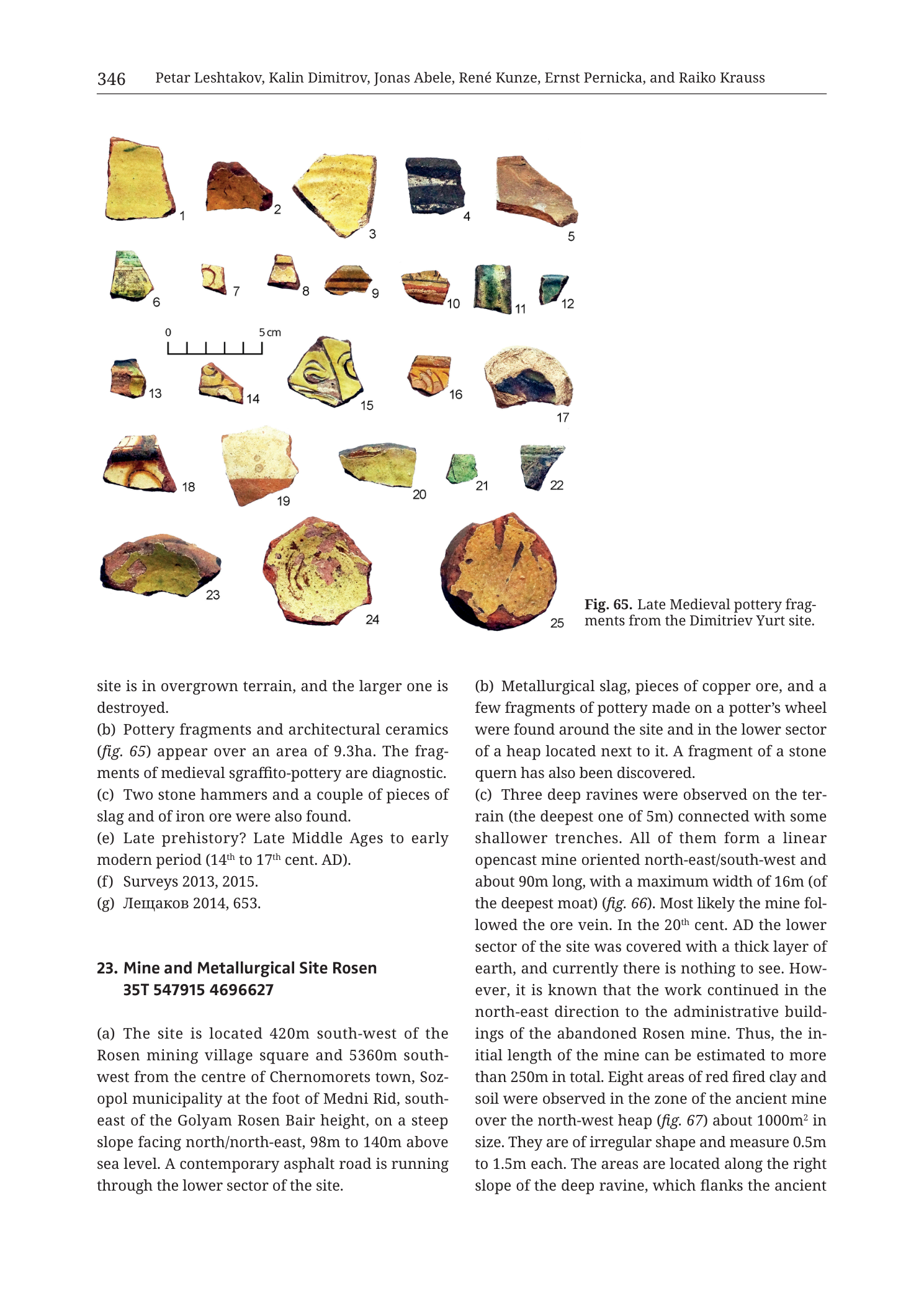
Caption (right of lower pottery row): “Fig. 65. Late Medieval pottery fragments from the Dimitriev Yurt site.”
Scale bar: “0” … “5 cm” with intermediate ticks (left-centre of plate).
Numbered sherds (1–25), all glazed/decorated medieval pottery fragments unless noted:
- 1 — yellow-glazed body/rim sherd
- 2 — orange-brown glazed sherd
- 3 — yellow glazed sherd
- 4 — dark glazed (brown/black) rectangular sherd
- 5 — orange-tan glazed sherd
- 6 — green-glazed sherd with lighter interior/exterior contrast
- 7 — small glazed fragment
- 8 — small glazed fragment with horizontal band
- 9 — small sherd with painted/sgraffito band
- 10 — small sherd with red-brown painted bands
- 11 — green-glazed curved sherd
- 12 — small green glazed chip
- 13 — small polychrome/banded sherd
- 14 — sgraffito-decorated sherd with incised design under glaze
- 15 — larger sgraffito sherd with yellow glaze and dark incised curvilinear design
- 16 — small sgraffito/painted sherd
- 17 — bowl fragment, light fabric with dark interior residue or glaze patch
- 18 — sgraffito sherd with circular/curved incised motif under yellow-brown glaze
- 19 — rim/body sherd, reddish fabric with glaze traces
- 20 — green-glazed body sherd
- 21 — small bright green glazed chip (possibly glass or high-lead glaze)
- 22 — green-glazed curved sherd
- 23 — bowl base/body fragment, yellow-green glaze interior
- 24 — large bowl base with yellow glaze and circular sgraffito/painted design
- 25 — large circular base (footring visible), yellow-brown glazed interior with dark motifs
Body text — end of entry 22 (Dimitriev Yurt)
(Continues from previous page mid-sentence:)
“site is in overgrown terrain, and the larger one is destroyed.”
“(b) Pottery fragments and architectural ceramics (fig. 65) appear over an area of 9.3ha. The fragments of medieval sgraffito-pottery are diagnostic.”
“(c) Two stone hammers and a couple of pieces of slag and of iron ore were also found.”
“(e) Late prehistory? Late Middle Ages to early modern period (14th to 17th cent. AD).”
“(f) Surveys 2013, 2015.”
“(g) Лещаков 2014, 653.”
- Translation: Leshtakov 2014, 653.
Entry 23 — Mine and Metallurgical Site Rosen (partial; continues off-page)
Heading: “23. Mine and Metallurgical Site Rosen 35T 547915 4696627”
“(a) The site is located 420m south-west of the Rosen mining village square and 5360m south-west from the centre of Chernomorets town, Sozopol municipality at the foot of Medni Rid, south-east of the Golyam Rosen Bair height, on a steep slope facing north/north-east, 98m to 140m above sea level. A contemporary asphalt road is running through the lower sector of the site.”
“(b) Metallurgical slag, pieces of copper ore, and a few fragments of pottery made on a potter’s wheel were found around the site and in the lower sector of a heap located next to it. A fragment of a stone quern has also been discovered.”
“(c) Three deep ravines were observed on the terrain (the deepest one of 5m) connected with some shallower trenches. All of them form a linear opencast mine oriented north-east/south-west and about 90m long, with a maximum width of 16m (of the deepest moat) (fig. 66). Most likely the mine followed the ore vein. In the 20th cent. AD the lower sector of the site was covered with a thick layer of earth, and currently there is nothing to see. However, it is known that the work continued in the north-east direction to the administrative buildings of the abandoned Rosen mine. Thus, the initial length of the mine can be estimated to more than 250m in total. Eight areas of red fired clay and soil were observed in the zone of the ancient mine over the north-west heap (fig. 67) about 1000m² in size. They are of irregular shape and measure 0.5m to 1.5m each. The areas are located along the right slope of the deep ravine, which flanks the ancient”
(text ends mid-sentence at page break.)
Description
TYPE & PURPOSE
Catalogue page closing 22. Dimitriev Yurt (with its diagnostic Late Medieval sgraffito pottery plate, Fig. 65) and opening the critical 23. Mine and Metallurgical Site Rosen entry — the catalogue treatment of ancient/historical mining and metallurgy at the Rosen mine itself on the Medni Rid foot-slope SE of Golyam Rosen Bair.
Purpose for the filename target (n23 Rosen): locate the Rosen mine-and-metallurgical complex relative to Rosen village and Chernomorets; describe slag, copper ore, wheel-made pottery, quern fragment; and document the NE–SW linear opencast (ravines/trenches ~90 m visible, estimated >250 m original), plus red fired-clay patches interpreted in association with the ancient mine and heaps (figs. 66–67 on following pages).
OVERALL PAGE LAYOUT
- Upper ~half: full-width studio plate Fig. 65 (25 sherds).
- Lower half: two text columns — left ends entry 22 and starts entry 23 (a); right continues entry 23 (b)(c).
- Printed page 346.
- No topographic map on this page.
Fig. 65 — LATE MEDIEVAL POTTERY FROM DIMITRIEV YURT
Type. Studio plate of 25 glazed and sgraffito pottery fragments, white background, scale 0–5 cm.
Ware character.
- Predominance of yellow, green, and brown lead-glazed sherds.
- Clear sgraffito decoration on multiple pieces (incised designs under yellow glaze), especially items 14, 15, 18, 24 — matching body text “fragments of medieval sgraffito-pottery are diagnostic.”
- Forms include body sherds, rims, and several bowl bases (23, 24, 25) with glazed interiors.
- Item 21 is a small bright green chip that may be high-lead glaze or glass; left with the pottery plate as printed numbering indicates.
Analytical role. Dates/characterises the medieval occupation component of Dimitriev Yurt (14th–17th cent. AD in field e) over the stated 9.3 ha scatter; not finds from the Rosen mine entry.
ENTRY 22 CLOSE — DIMITRIEV YURT
Completing prior page:
- End of structural note: part of site overgrown; larger [structure?] destroyed.
- (b) Pottery and architectural ceramics (fig. 65) over 9.3 ha; medieval sgraffito pottery diagnostic.
- (c) Two stone hammers; pieces of slag and iron ore also found.
- (e) Late prehistory? Late Middle Ages to early modern (14th–17th cent. AD).
- (f) Surveys 2013, 2015.
- (g) Лещаков 2014, 653.
Stone hammers + slag + iron ore at Dimitriev Yurt indicate a metallurgical/mining-adjacent component beside the medieval ceramic scatter.
ENTRY 23 — MINE AND METALLURGICAL SITE ROSEN (PARTIAL)
- Centroid: 35T 547915 4696627
- (a) Location:
- 420 m SW of the Rosen mining village square;
- 5360 m SW of Chernomorets town centre, Sozopol municipality;
- at the foot of Medni Rid, SE of Golyam Rosen Bair height;
- steep slope facing N/NE;
- 98–140 m a.s.l.;
- contemporary asphalt road through the lower sector.
- (b) Finds: metallurgical slag; copper ore pieces; few wheel-made pottery fragments — around the site and in the lower sector of an adjacent heap; also a stone quern fragment.
- (c) Mine morphology and related features (as printed to page break):
- three deep ravines (deepest 5 m) plus shallower trenches;
- together form a linear opencast mine oriented NE–SW, about 90 m long, max width 16 m (deepest moat) (fig. 66);
- most likely followed the ore vein;
- 20th-century earth cover on the lower sector — currently nothing visible there;
- workings known to have continued NE toward administrative buildings of the abandoned Rosen mine → estimated original length >250 m;
- eight areas of red fired clay and soil in the ancient-mine zone on the NW heap (fig. 67), together about 1000 m²; irregular shapes, each 0.5–1.5 m; located along the right slope of the deep ravine flanking the ancient [mine — sentence cuts off].
SPATIAL RELATIONSHIPS (PAGE-LEVEL)
- Rosen mine/metallurgical site sits on the Medni Rid foot-slope at Golyam Rosen Bair’s SE side, only 420 m from Rosen village square — i.e. the catalogue’s on-ridge mining locus for the namesake Rosen deposit cluster treated in Tzankova (2023) and other volume chapters.
- Elevation 98–140 m places it well above the coastal plain sites (Akladi Cheiri 1–4 m; Atia 30–70 m) and in the hill belt of ancient open-cast vein mining.
- Linear NE–SW opencast parallel to expected vein strike in the Rosen field (NW–SE to NE–SW vein systems appear across the collection) — text explicitly “most likely the mine followed the ore vein.”
- Modern/20th-century mining and earth-moving obscure the lower sector; ancient trace is read from ravines, heaps, slag/ore scatter, and fired-clay patches (possible furnace/hearth residues — interpretation deferred where not explicit).
- Dimitriev Yurt (closing here) lies further toward Chernomorets SW approaches (centroid 550104/4696800 on prior page) as a large medieval ceramic scatter with minor slag/ore/hammers — different function and period emphasis from Rosen’s linear mine.
- UTM 547915 E / 4696627 N is valid 35T and sits west of Chernomorets coastal eastings (~552–553k) and east of more westerly Varli Bryag (~532k), matching the central Rosen village sector of Medni Rid.
RELATIONSHIP TO OTHER FIGURES
- Entry 22 (b) → fig. 65 (this page).
- Entry 23 (c) → fig. 66 (opencast; not on this page), fig. 67 (fired-clay areas / heap; not on this page).
- Filename n23 Rosen; Fig. 65 belongs analytically to Dimitriev Yurt (entry 22).
Consistency Check
- No coordinate-gridded map on this page → N/A.
- Rosen centroid 35T 547915 4696627: Easting and Northing within expected SE-Bulgaria 35T ranges; consistent with Rosen village / Medni Rid foot-slope prose.
- Result: N/A (no map axes).
Notes
- Filename p348 vs printed 346 — standard offset; printed page authoritative.
- Entry 23 truncated mid-(c); fields (d)–(g) and figs. 66–67 are on subsequent page(s).
- Fig. 65 item descriptions are visual morphology; ware names beyond “sgraffito” / glazed are not printed per sherd.
- “Moat” in (c) is the text’s term for the deepest opencast cut (max width 16 m).
- Fired-clay patches are described observationally in (c); the page does not explicitly label them “furnaces” on this leaf — keep description at the printed wording.
- None further.