Description
Transcription
Page header
- Header (centred top): “Catalogue of Investigated Archaeological Sites and Mining Places”
- Page number (top-right): 345
Fig. 61 — Excavation photograph (upper-left)
Caption: “Fig. 61. Akladi Cheiri. Rescue excavations in 2008.”
No text on the photograph itself.
Fig. 62 — Excavation photograph (upper-right)
Caption: “Fig. 62. Akladi Cheiri. View on the eastern section of the excavated area with several pit features after a heavy rainfall.”
No text on the photograph itself.
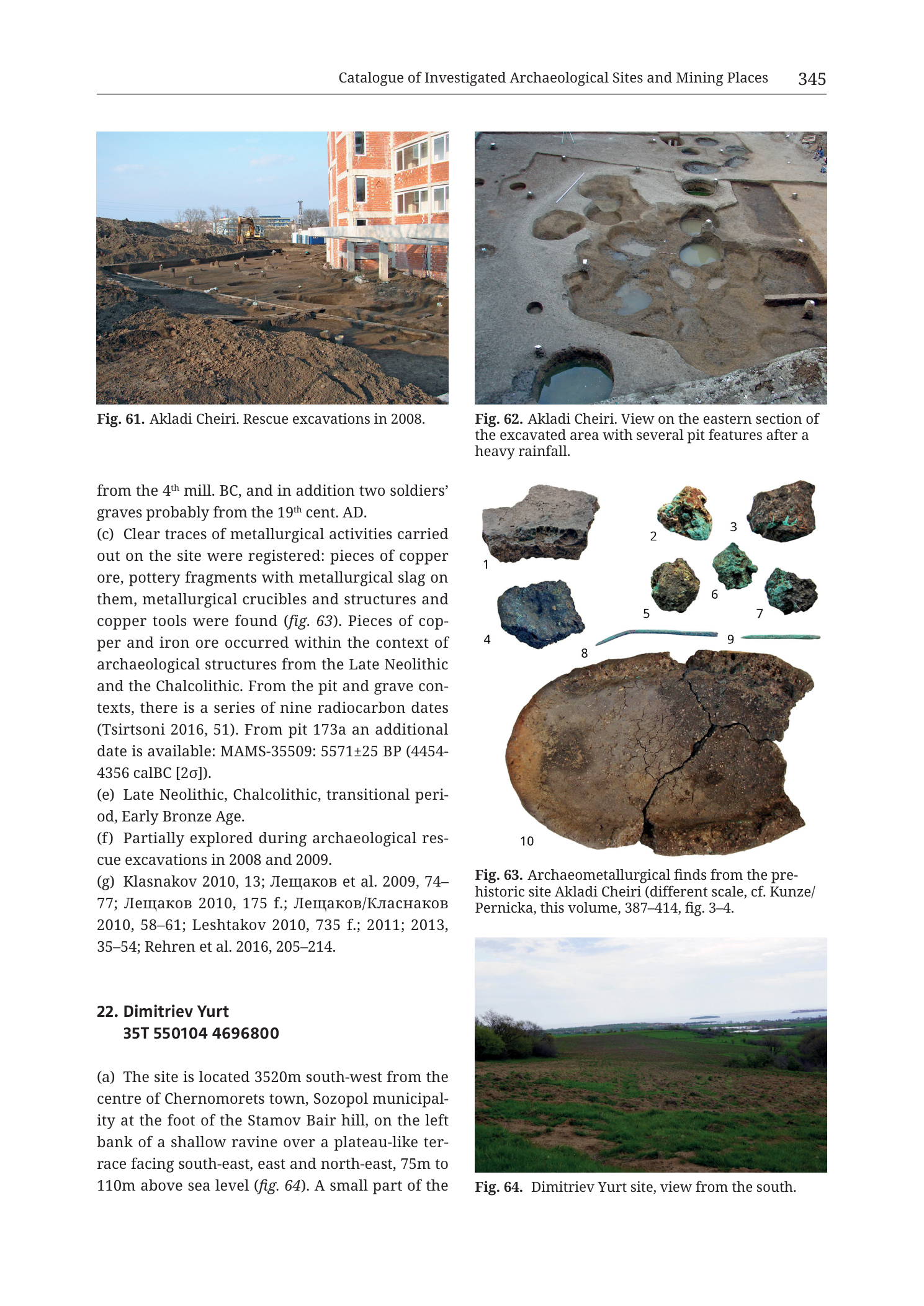
Fig. 63 — Archaeometallurgical finds plate (middle-right)
Caption: “Fig. 63. Archaeometallurgical finds from the prehistoric site Akladi Cheiri (different scale, cf. Kunze/Pernicka, this volume, 387–414, fig. 3–4.”
(Note: closing parenthesis as printed may be incomplete in the caption line; transcribed as visible.)
Numbered finds (1–10):
- 1 — large flat irregular grey-brown slag or furnace-related cake / cake-like piece
- 2 — small green copper-corroded lump (malachite-stained ore or copper corrosion product)
- 3 — dark angular ore/slag fragment with green copper staining on surface
- 4 — dark blue-black dense slag or ore lump
- 5 — rounded dark lump (slag/ore)
- 6 — small green-stained copper-mineral fragment
- 7 — dark lump with green copper staining
- 8 — thin curved green copper wire / awl / pin fragment (elongated metal object with green patina)
- 9 — thin straight green copper wire / pin / awl fragment (elongated metal object with green patina)
- 10 — large cracked circular/oval ceramic object — crucible or thermal ceramic base/vessel bottom with thick walls, broken rim sector, dark heat-altered interior surface
No scale bar printed on this composite plate (caption states “different scale” and points to Kunze/Pernicka figs. 3–4 for scaled treatment).
Fig. 64 — Landscape photograph (lower-right)
Caption: “Fig. 64. Dimitriev Yurt site, view from the south.”
No text on the photograph itself.
Body text — continuation and close of entry 21 (Akladi Cheiri)
(Continues mid-sentence from previous page, after “dating”:)
“from the 4th mill. BC, and in addition two soldiers’ graves probably from the 19th cent. AD.”
“(c) Clear traces of metallurgical activities carried out on the site were registered: pieces of copper ore, pottery fragments with metallurgical slag on them, metallurgical crucibles and structures and copper tools were found (fig. 63). Pieces of copper and iron ore occurred within the context of archaeological structures from the Late Neolithic and the Chalcolithic. From the pit and grave contexts, there is a series of nine radiocarbon dates (Tsirtsoni 2016, 51). From pit 173a an additional date is available: MAMS-35509: 5571±25 BP (4454-4356 calBC [2σ]).”
“(e) Late Neolithic, Chalcolithic, transitional period, Early Bronze Age.”
“(f) Partially explored during archaeological rescue excavations in 2008 and 2009.”
“(g) Klasnakov 2010, 13; Лещаков et al. 2009, 74–77; Лещаков 2010, 175 f.; Лещаков/Класнаков 2010, 58–61; Leshtakov 2010, 735 f.; 2011; 2013, 35–54; Rehren et al. 2016, 205–214.”
- Translation (selected Cyrillic bibliographic surnames): Leshtakov et al. 2009; Leshtakov 2010; Leshtakov/Klasnakov 2010.
Entry 22 — Dimitriev Yurt (start only)
Heading: “22. Dimitriev Yurt 35T 550104 4696800”
“(a) The site is located 3520m south-west from the centre of Chernomorets town, Sozopol municipality at the foot of the Stamov Bair hill, on the left bank of a shallow ravine over a plateau-like terrace facing south-east, east and north-east, 75m to 110m above sea level (fig. 64). A small part of the”
(text ends mid-sentence at page break; remainder not in this PNG.)
Description
TYPE & PURPOSE
Catalogue plate completing 21. Prehistoric Site Akladi Cheiri with excavation photography, a key archaeometallurgical finds plate, full metallurgical and radiocarbon discussion, dating, fieldwork, and bibliography; and opening 22. Dimitriev Yurt with its landscape view.
This is the archaeometallurgical core page for Akladi Cheiri: it documents copper ore, slagged pottery, crucibles, metallurgical structures, copper tools, and absolute dates that place metallurgy in Late Neolithic–Chalcolithic contexts on the Chernomorets coastal plain at the foot of the Medni Rid system.
OVERALL PAGE LAYOUT
- Portrait two-column layout.
- Left: Fig. 61; continuation/close of entry 21 (end of b, full c, e, f, g); start of entry 22 (heading, centroid, start of a).
- Right: Fig. 62; Fig. 63 finds plate; Fig. 64 landscape.
- Printed page 345.
Fig. 61 — AKLADI CHEIRI RESCUE EXCAVATIONS 2008
- Colour photograph of an active rescue excavation beside modern construction.
- Right side: multi-storey building under construction / new build with red brick and concrete columns.
- Centre-left: open excavated ground surface with darker soil patches, pit outlines, and baulks — archaeological trenches at foundation/development level.
- Background: excavator/construction plant and further buildings under pale sky.
- Documents the rescue context of the 2008 campaign cited in entry 21 (f) and in the previous page’s reference to investigated areas 2008–2009.
Fig. 62 — EASTERN SECTION, PIT FEATURES AFTER RAINFALL
- Overhead / high-oblique colour photograph of a cleaned excavation surface.
- Multiple circular and irregular pit features cut into lighter sediment; several pits hold rainwater (dark reflective pools), accentuating plan shapes.
- Pits of varying diameter cluster across the trench; some intercut or adjoin.
- Small white labels/markers visible on the surface.
- Illustrates the “70 dug-in structures” and pit-rich eastern excavation sector described in entry 21 (b) on the previous page; rainfall-filled pits make negative features photographically clear.
Fig. 63 — ARCHAEOMETALLURGICAL FINDS FROM AKLADI CHEIRI
Type. Studio composite plate of ten numbered archaeometallurgical objects on white background; explicitly multi-scale (“different scale”).
Object groups.
- Slag / furnace products: item 1 (large cake-like piece), items 4, 5, and possibly 3/7 as dark slaggy lumps — waste from high-temperature metallurgical processing.
- Copper ore / secondary copper minerals: items 2, 6 and green-stained surfaces on 3 and 7 — green copper carbonates/corrosion indicating copper-bearing materials.
- Copper tools / metal objects: items 8 and 9 — thin elongated green-patinated copper implements (wire, pin, or awl morphology).
- Technical ceramic / crucible: item 10 — large, thick-walled, cracked oval/round ceramic vessel bottom or crucible with heat-darkened interior and a broken sector of the rim/wall; the dominant object by size on the plate.
Caption cross-reference. Points to Kunze/Pernicka chapter in the same volume (pp. 387–414, figs. 3–4) for properly scaled, specialist treatment of these or related finds.
Analytical role. Direct visual support for entry 21 (c): copper ore, slagged ceramics, crucibles, structures, and copper tools as “clear traces of metallurgical activities.”
Fig. 64 — DIMITRIEV YURT, VIEW FROM SOUTH
- Colour landscape photograph from the south (caption).
- Foreground/mid-ground: open plateau-like terrace with mixed green vegetation and brown bare soil patches.
- Background: low coastal plain, water bodies / lagoons or sea inlets, and distant shore under a cloudy sky.
- No people or excavation gear visible.
- Sets the geographic scene for entry 22 at the foot of Stamov Bair on a SE/E/NE-facing terrace (75–110 m a.s.l. per text).
ENTRY 21 CLOSE — PREHISTORIC SITE AKLADI CHEIRI
Completing the entry begun on the previous page:
- End of (b): burials dating from the 4th millennium BC; plus two soldiers’ graves probably 19th cent. AD.
- (c) Metallurgy: clear on-site metallurgical activity — copper ore pieces; pottery with metallurgical slag adhering; metallurgical crucibles and structures; copper tools (fig. 63). Copper and iron ore pieces in Late Neolithic and Chalcolithic structure contexts. Radiocarbon: series of nine dates from pit and grave contexts (Tsirtsoni 2016, 51); additional date from pit 173a: MAMS-35509: 5571±25 BP (4454–4356 calBC [2σ]).
- (e) Dating: Late Neolithic, Chalcolithic, transitional period, Early Bronze Age.
- (f) Fieldwork: partially explored in archaeological rescue excavations 2008 and 2009.
- (g) Bibliography: Klasnakov 2010, 13; Лещаков et al. 2009, 74–77; Лещаков 2010, 175 f.; Лещаков/Класнаков 2010, 58–61; Leshtakov 2010, 735 f.; 2011; 2013, 35–54; Rehren et al. 2016, 205–214.
Field (d) is not printed on this page for entry 21.
ENTRY 22 START — DIMITRIEV YURT
- Centroid: 35T 550104 4696800
- (a) 3520 m SW of Chernomorets centre, Sozopol municipality; foot of Stamov Bair hill; left bank of a shallow ravine on a plateau-like terrace facing SE, E, and NE; 75–110 m a.s.l. (fig. 64). Sentence continues off-page: “A small part of the…”
SPATIAL RELATIONSHIPS (PAGE-LEVEL)
- Akladi Cheiri metallurgy is embedded in a Late Neolithic–Early Bronze Age coastal settlement with dozens of dug-in features, houses, thermal structures, and 4th-millennium BC burials, later cut by 19th-century soldiers’ graves — a multi-period palimpsest under modern construction pressure (Fig. 61).
- Copper ore + crucibles + slagged pottery + copper tools on one site, with ore also in LN/Chalcolithic structure fills, make Akladi Cheiri a primary archaeometallurgical node on the shore plain east of Medni Rid, complementary to the inland/ridge mines and secondary-copper workings catalogued elsewhere.
- Absolute date MAMS-35509 (4454–4356 calBC) anchors at least one pit context in the mid-5th millennium cal BC.
- Dimitriev Yurt opens as a higher terrace site (75–110 m) SW of Chernomorets at Stamov Bair — inland/up-slope relative to Akladi Cheiri’s 1–4 m coastal setting — continuing the Chernomorets municipality sequence.
- Rehren et al. 2016 and Kunze/Pernicka (this volume) signal that the metallurgical finds receive specialist laboratory treatment beyond this catalogue summary.
RELATIONSHIP TO OTHER FIGURES
- Entry 21 (b) on prior page → figs. 61–62 (both on this page); (c) → fig. 63 (this page).
- Fig. 63 → Kunze/Pernicka, this volume, 387–414, figs. 3–4 (specialist chapter).
- Entry 22 (a) → fig. 64 (this page).
- Prior page Fig. 59–60 located Akladi Cheiri; this page documents excavation and metallurgy.
Consistency Check
- No coordinate-gridded map on this page → N/A.
- Dimitriev Yurt centroid 35T 550104 4696800 lies within valid SE-Bulgaria 35T ranges; easting west of Akladi Cheiri’s 552864 and northing similar (~4696800), consistent with a more inland SW-of-Chernomorets position at higher elevation.
- Result: N/A (no map axes).
Notes
- Filename
Cat_p347_...vs printed page 345 — collection page offset; printed 345 is authoritative. - Fig. 63 has no on-plate scale; caption warns scales differ and defers to Kunze/Pernicka figs. 3–4.
- Item 10 is identified in body text context as among “metallurgical crucibles”; visual morphology (thick heat-altered ceramic basin) supports that reading.
- Green surface colours on finds 2, 3, 6, 7, 8, 9 are observed copper staining/patina; specific mineral species (malachite vs corrosion) are not labelled on the plate.
- Radiocarbon string transcribed exactly: MAMS-35509: 5571±25 BP (4454-4356 calBC [2σ]).
- Entry 21 field (d) absent as printed; entry 22 truncated mid-(a).
- None further.