Description
Transcription
Page header
- Page number (top-left): 344
- Header: “Petar Leshtakov, Kalin Dimitrov, Jonas Abele, René Kunze, Ernst Pernicka, and Raiko Krauss”
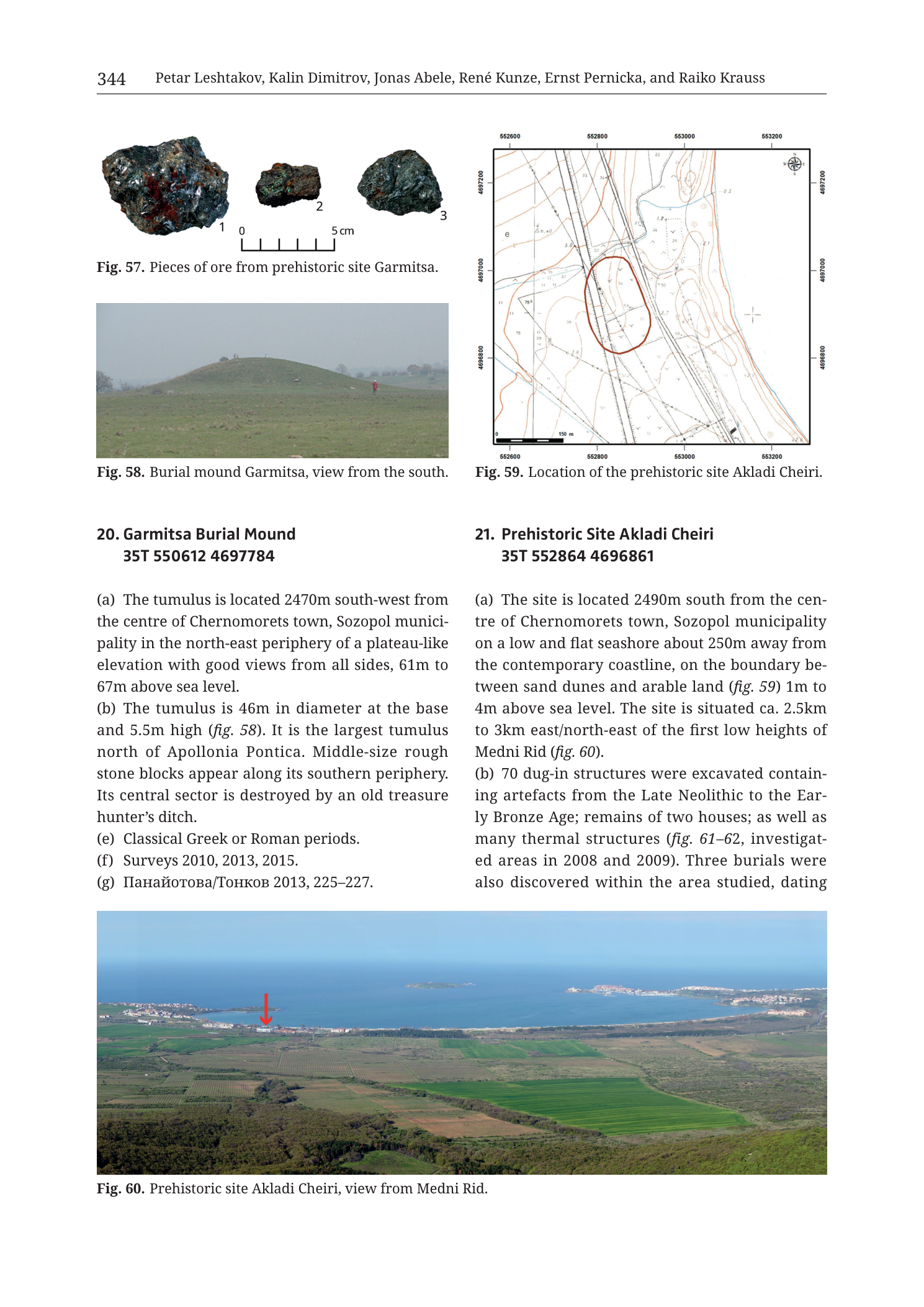
Fig. 57 — Ore specimens (upper-left)
Caption: “Fig. 57. Pieces of ore from prehistoric site Garmitsa.”
Scale bar: “0” … “5 cm” with intermediate tick marks.
Numbered specimens:
- 1 — larger dark metallic/ore lump (left), irregular, with mottled dark grey to black surface and brownish patches
- 2 — smaller dark ore piece (centre)
- 3 — medium dark ore piece (right)
Fig. 58 — Burial mound photograph (middle-left)
Caption: “Fig. 58. Burial mound Garmitsa, view from the south.”
No text on the photograph itself. A human scale figure (person in red) stands to the right of the mound.
Fig. 59 — Location map (upper-right)
Caption: “Fig. 59. Location of the prehistoric site Akladi Cheiri.”
Coordinate grid labels (UTM-style metre ticks):
- Top edge (Easting, left → right): 552600 | 552800 | 553000 | 553200
- Bottom edge (Easting, left → right): 552600 | 552800 | 553000 | 553200
- Left edge (Northing, top → bottom): 4697200 | 4697000 | 4696800
- Right edge (Northing, top → bottom): 4697200 | 4697000 | 4696800
Other map annotations:
- North arrow / compass rose: upper-right inside map frame.
- Scale bar (lower-left inside map): labelled “150 m”.
- Large red oval outline enclosing the central site area (elongated roughly N–S to NNW–SSE).
- Contour lines in brown with elevation labels (including values in the ~2–11+ m coastal range and higher inland labels where printed — small numerals along contours).
- Road/track lines: solid and dashed, including a prominent diagonal road corridor running roughly NW–SE through/near the eastern side of the red oval.
- Building footprints: black rectangles clustered especially NE and along roads (modern coastal settlement fabric).
- Shoreline / coastal features along the eastern and southeastern map area (coast complex with embayments).
- Spot heights and survey marks with small elevation numbers across the map face.
Fig. 60 — Panoramic photograph (full page width, bottom)
Caption: “Fig. 60. Prehistoric site Akladi Cheiri, view from Medni Rid.”
Overprinted symbol: red downward arrow pointing to a coastal locus left-of-centre in the mid-distance (the site position).
No other text on the photograph.
Entry 20 — Garmitsa Burial Mound (left column)
Heading: “20. Garmitsa Burial Mound 35T 550612 4697784”
“(a) The tumulus is located 2470m south-west from the centre of Chernomorets town, Sozopol municipality in the north-east periphery of a plateau-like elevation with good views from all sides, 61m to 67m above sea level.”
“(b) The tumulus is 46m in diameter at the base and 5.5m high (fig. 58). It is the largest tumulus north of Apollonia Pontica. Middle-size rough stone blocks appear along its southern periphery. Its central sector is destroyed by an old treasure hunter’s ditch.”
“(e) Classical Greek or Roman periods.”
“(f) Surveys 2010, 2013, 2015.”
“(g) Панайотова/Тонков 2013, 225–227.”
- Translation (bibliographic surnames): Panayotova/Tonkov 2013, 225–227.
Entry 21 — Prehistoric Site Akladi Cheiri (right column; text continues beyond page)
Heading: “21. Prehistoric Site Akladi Cheiri 35T 552864 4696861”
“(a) The site is located 2490m south from the centre of Chernomorets town, Sozopol municipality on a low and flat seashore about 250m away from the contemporary coastline, on the boundary between sand dunes and arable land (fig. 59) 1m to 4m above sea level. The site is situated ca. 2.5km to 3km east/north-east of the first low heights of Medni Rid (fig. 60).”
“(b) 70 dug-in structures were excavated containing artefacts from the Late Neolithic to the Early Bronze Age; remains of two houses; as well as many thermal structures (fig. 61–62, investigated areas in 2008 and 2009). Three burials were also discovered within the area studied, dating”
(text ends mid-sentence at page break; remainder of entry 21 continues on the next page, not fully in this PNG).
Description
TYPE & PURPOSE
Catalogue plate page from Krauss et al. (2020) pairing two Chernomorets-area sites:
- 20. Garmitsa Burial Mound — with ore specimens (Fig. 57), mound photo (Fig. 58), and full short catalogue entry;
- 21. Prehistoric Site Akladi Cheiri — with gridded location map (Fig. 59), panoramic view from Medni Rid (Fig. 60), and the opening of a longer excavation-summary entry.
Purpose for the filename target (n21 Akladi Cheiri): fix the Late Neolithic–Early Bronze Age coastal settlement on the sand-dune / arable boundary south of Chernomorets, ~250 m inland of the modern shoreline and 2.5–3 km E/NE of the first Medni Rid heights, and summarise the excavated dug-in structures, houses, thermal features, and burials.
OVERALL PAGE LAYOUT
- Portrait page; upper two-thirds in two columns; lower third a full-width panorama.
- Left column: Fig. 57, Fig. 58, entry 20.
- Right column: Fig. 59, entry 21 start.
- Bottom full width: Fig. 60.
- Printed page 344.
Fig. 57 — ORE FROM PREHISTORIC SITE GARMITSA
- Studio photograph, white background, three dark ore lumps numbered 1–3.
- Scale 0–5 cm.
- Specimens are dense, dark grey–black with irregular broken surfaces; specimen 1 is largest and shows brownish oxidation patches; 2 and 3 are smaller compact pieces.
- Caption assigns them to “prehistoric site Garmitsa” — note the catalogue heading on this page titles entry 20 as Garmitsa Burial Mound; the ore plate caption uses “prehistoric site Garmitsa,” linking ore finds to the Garmitsa locus broadly.
- No mineral names are printed on the figure (malachite/sulphide etc. not labelled here).
Fig. 58 — GARMITSA BURIAL MOUND
- Colour landscape photo, view from the south (caption).
- Large grass-covered tumulus dominates the centre; smooth hemispherical profile.
- A person in red stands to the right mid-ground, providing human scale against the ~5.5 m height stated in text.
- Open pasture surroundings; overcast/pale sky; low vegetation and distant trees on the horizon.
- Illustrates entry 20 (b) dimensions and the mound’s monumental local status (“largest tumulus north of Apollonia Pontica”).
Fig. 59 — LOCATION MAP, AKLADI CHEIRI
Type & purpose. Large-scale topographic location map of the prehistoric site Akladi Cheiri on the Chernomorets coastal plain, with a red oval marking the site extent.
Frame, extent, orientation.
- Square map frame.
- North arrow / compass rose upper-right; north up.
- Easting span 552600–553200 = 600 m; northing span 4696800–4697200 = 400 m. Ground window ~600 m E–W by ~400 m N–S.
Scale.
- Scale bar labelled 150 m (lower-left inside frame).
- No ratio scale printed.
Coordinates / grid.
- Easting ticks: 552600, 552800, 553000, 553200 (200 m).
- Northing ticks: 4697200, 4697000, 4696800 (200 m).
- Zone not printed on map face; catalogue heading gives 35T.
Relief & physiography.
- Brown contours depict very low coastal relief. Elevations on and near the site are only a few metres a.s.l., matching body text 1–4 m.
- Gentle contour gradients across most of the frame; slightly more relief toward inland (western) side.
- Eastern/southeastern sector approaches the Black Sea coastal complex (shoreline embayments and coastal morphology drawn).
Hydrography & coast.
- Modern coastline and coastal inlets along the east/SE edge of the map.
- No named river printed on this local map; site sits on flat seashore / dune–arable boundary per text.
Anthropogenic features.
- Modern building footprints (black rectangles), denser toward NE and along the main road corridor.
- Prominent road running roughly NW–SE, passing beside/through the eastern margin of the red site oval — modern access/settlement fabric of the Chernomorets coastal strip.
- Red oval = prehistoric site Akladi Cheiri extent as mapped for the catalogue.
Geological content.
- None as coloured units; pure topographic/cadastral-style base.
Spatial reading of Fig. 59.
- Site oval sits slightly west of map centre, on the low flat ground between inland contours and the coastal strip, consistent with “~250 m from contemporary coastline” and “boundary between sand dunes and arable land.”
- Centroid 552864 E / 4696861 N falls inside the red oval region near the southern half of the map’s northing range.
Fig. 60 — AKLADI CHEIRI FROM MEDNI RID
- Wide colour panoramic photograph looking from elevated Medni Rid ground toward the Black Sea coast.
- Foreground: wooded/brushy near slope of Medni Rid.
- Mid-ground: patchwork of green agricultural fields and darker tree lines on the coastal plain.
- Background: Black Sea with a large bay/embayment; coastal settlement and peninsula forms (Chernomorets / Sozopol coastal complex) visible along the shore.
- Red arrow points down to a specific coastal-plain locus left of centre — the Akladi Cheiri position relative to Medni Rid and the sea.
- Demonstrates the text claim that the site lies ca. 2.5–3 km E/NE of the first low heights of Medni Rid, with clear visual separation between the ridge viewpoint and the shoreline site.
ENTRY 20 — GARMITSA BURIAL MOUND
- Centroid: 35T 550612 4697784
- (a) 2470 m SW of Chernomorets centre, Sozopol municipality; NE periphery of plateau-like elevation; good views all sides; 61–67 m a.s.l.
- (b) Base diameter 46 m; height 5.5 m (fig. 58); largest tumulus north of Apollonia Pontica; middle-size rough stone blocks along southern periphery; central sector destroyed by old treasure-hunter’s ditch.
- (e) Classical Greek or Roman periods.
- (f) Surveys 2010, 2013, 2015.
- (g) Панайотова/Тонков 2013, 225–227.
- Fields (c)(d) not printed on this page.
- Fig. 57 ore pieces are captioned to Garmitsa prehistoric site context alongside this burial-mound entry.
ENTRY 21 — PREHISTORIC SITE AKLADI CHEIRI (PARTIAL)
- Centroid: 35T 552864 4696861
- (a) 2490 m south of Chernomorets centre, Sozopol municipality; low flat seashore ~250 m from contemporary coastline; boundary sand dunes / arable land (fig. 59); 1–4 m a.s.l.; ca. 2.5–3 km E/NE of first low heights of Medni Rid (fig. 60).
- (b) 70 dug-in structures excavated with Late Neolithic to Early Bronze Age artefacts; remains of two houses; many thermal structures (figs. 61–62; investigated areas 2008 and 2009); three burials also discovered within the studied area, dating … [sentence continues off-page].
- Remaining fields and dating completion not on this image.
SPATIAL RELATIONSHIPS (PAGE-LEVEL)
- Akladi Cheiri is a low coastal prehistoric settlement on the Chernomorets shore plain, only 1–4 m a.s.l. and ~250 m inland, east/northeast of Medni Rid’s first rises — i.e. between the metalliferous ridge and the Black Sea, not on the mine ridge itself.
- Garmitsa tumulus sits higher (61–67 m) on a plateau-like elevation SW of Chernomorets, inland of the immediate beach strip; its easting (~550612) is west of Akladi Cheiri (~552864), and its northing (~4697784) is north of Akladi Cheiri (~4696861) — two different micro-settings in the same Chernomorets municipality catalogue cluster.
- Fig. 60 explicitly ties Akladi Cheiri to the Medni Rid viewpoint, reinforcing the volume’s ridge-to-coast research frame: prehistoric habitation and thermal structures on the shore plain facing the copper-bearing ridge.
- Ore pieces at Garmitsa (Fig. 57) place raw mineral material in the same coastal-Chernomorets narrative as the Akladi Cheiri prehistoric industrial/thermal features cited in (b).
RELATIONSHIP TO OTHER FIGURES
- Entry 20 (b) → fig. 58; ore context → fig. 57.
- Entry 21 (a) → figs. 59, 60; (b) → figs. 61–62 (not on this page; excavation plans/photos on following plates).
- Filename targets n21 Akladi Cheiri; Garmitsa content co-occurs by catalogue pagination.
Consistency Check
- Centroid (entry 21): 35T 552864 4696861
- Map bounds (Fig. 59): Easting [552600–553200], Northing [4696800–4697200]
- Easting: 552600 ≤ 552864 ≤ 553200 → PASS
- Northing: 4696800 ≤ 4696861 ≤ 4697200 → PASS
- Result: PASS
- Entry 20 centroid 35T 550612 4697784 lies west/north of Fig. 59’s window (different site; no map on this page for Garmitsa) — expected.
Notes
- Filename encodes p346 vs printed page 344 — standard collection page-offset pattern; trust the printed header.
- Entry 21 text is truncated mid-sentence after “dating”; full chronology, fields (c)–(g), and excavation figures 61–62 are not on this PNG.
- Contour numerals on Fig. 59 are small; site elevations are securely constrained by body text (1–4 m a.s.l.) and low-relief contour pattern rather than every tiny contour label.
- Fig. 57 caption says “prehistoric site Garmitsa” while entry 20 heading is “Garmitsa Burial Mound” — same toponym, possibly broader locus vs mound feature; not resolved on this page alone.
- Apollonia Pontica = ancient Sozopol, referenced for regional tumulus ranking.
- None further.