Description
Transcription
Page header
- Page number (top-left): 340
- Header (top, continuing right of page number): “Petar Leshtakov, Kalin Dimitrov, Jonas Abele, René Kunze, Ernst Pernicka, and Raiko Krauss”
Fig. 43 — Landscape photograph (upper-left)
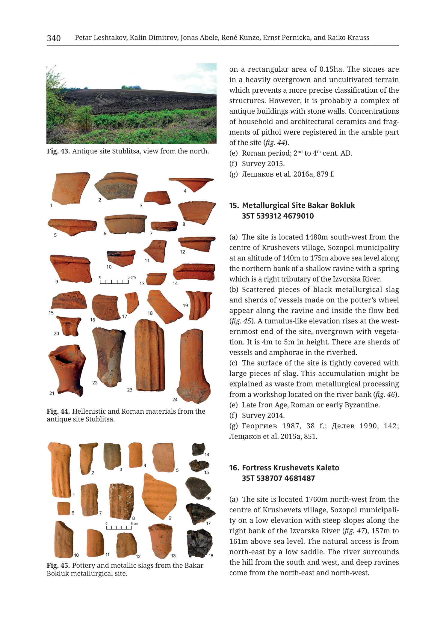
Caption: “Fig. 43. Antique site Stublitsa, view from the north.”
No text on the photograph itself.
Fig. 44 — Artefact plate (middle-left)
Caption: “Fig. 44. Hellenistic and Roman materials from the antique site Stublitsa.”
Scale bar on plate: “0” … “5 cm” (bar with tick subdivisions between 0 and 5 cm).
Numbered objects on the plate (as labelled):
- 1 — reddish pottery body/rim sherd
- 2 — reddish pottery body sherd
- 3 — reddish pottery rim/body sherd
- 4 — small reddish rim sherd (upper right of upper group)
- 5 — reddish rim sherd with horizontal profile
- 6 — bowl/cup profile, reddish, open form
- 7 — small open bowl/cup, reddish
- 8 — rim sherd, reddish (right of 7)
- 9 — large rim sherd with outward profile, reddish
- 10 — small rim/neck fragment, reddish
- 11 — small rim fragment, reddish
- 12 — thick rim sherd with horizontal lip, reddish
- 13 — small cup/bowl base or lower body, reddish
- 14 — rim sherd, reddish
- 15 — rim/body sherd, reddish
- 16 — curved body sherd, reddish
- 17 — small angular sherd, reddish
- 18 — rim sherd, reddish
- 19 — large ridged / grooved body or rim fragment, reddish
- 20 — small vessel fragment (neck/shoulder), reddish
- 21 — nearly complete small jar/pot (or large profile-restorable vessel) with handles/lugs, reddish-orange fabric
- 22 — tall cylindrical / slightly tapering ceramic fragment (stand, pipe, or thick wall), reddish, vertical orientation
- 23 — tall cylindrical / slightly tapering ceramic fragment similar to 22, reddish, vertical
- 24 — tall cylindrical / slightly tapering ceramic fragment similar to 22–23, reddish, vertical
Fig. 45 — Artefact plate (lower-left)
Caption: “Fig. 45. Pottery and metallic slags from the Bakar Bokluk metallurgical site.”
Scale bar on plate: “0” … “5 cm” (bar with tick subdivisions; labelled “5 cm” at right end).
Numbered objects on the plate (as labelled):
Pottery (reddish-orange fabric, left and centre of plate):
- 1 — elongated tubular / nozzle-like ceramic fragment (possible tuyère or thick-walled tube), vertical
- 2 — similar tubular / thick-walled ceramic fragment, vertical
- 3 — shorter tubular ceramic fragment, vertical
- 4 — small cylindrical ceramic piece, vertical
- 5 — irregular pottery body/rim sherd
- 6 — small square-ish / blocky ceramic fragment
- 7 — rectangular body sherd with surface striations/ridges
- 8 — body sherd, reddish
- 9 — curved rim or body sherd
- 10 — elongated tubular ceramic fragment (lower row), vertical
- 11 — shorter tubular / blocky ceramic fragment, vertical
- 12 — blocky ceramic fragment, vertical
- 13 — curved rim/body sherd
Metallic slag (dark grey to black, right side of plate):
- 14 — small dark slag lump
- 15 — small dark slag lump
- 16 — larger flat/irregular dark slag piece
- 17 — irregular dark slag piece
- 18 — irregular dark slag piece (lowest of slag group)
Right-column body text — end of prior catalogue entry (Stublitsa; entry number heading not on this page)
Continuation (mid-sentence from previous page):
“on a rectangular area of 0.15ha. The stones are in a heavily overgrown and uncultivated terrain which prevents a more precise classification of the structures. However, it is probably a complex of antique buildings with stone walls. Concentrations of household and architectural ceramics and fragments of pithoi were registered in the arable part of the site (fig. 44).”
“(e) Roman period; 2nd to 4th cent. AD.”
“(f) Survey 2015.”
“(g) Лещаков et al. 2016a, 879 f.”
- Translation (bibliographic surname): Leshtakov et al. 2016a, 879 f.
Entry 15 — full text on this page
Heading: “15. Metallurgical Site Bakar Bokluk 35T 539312 4679010”
“(a) The site is located 1480m south-west from the centre of Krushevets village, Sozopol municipality at an altitude of 140m to 175m above sea level along the northern bank of a shallow ravine with a spring which is a right tributary of the Izvorska River.”
“(b) Scattered pieces of black metallurgical slag and sherds of vessels made on the potter’s wheel appear along the ravine and inside the flow bed (fig. 45). A tumulus-like elevation rises at the westernmost end of the site, overgrown with vegetation. It is 4m to 5m in height. There are sherds of vessels and amphorae in the riverbed.”
“(c) The surface of the site is tightly covered with large pieces of slag. This accumulation might be explained as waste from metallurgical processing from a workshop located on the river bank (fig. 46).”
“(e) Late Iron Age, Roman or early Byzantine.”
“(f) Survey 2014.”
“(g) Георгиев 1987, 38 f.; Делев 1990, 142; Лещаков et al. 2015a, 851.”
- Translation (bibliographic surnames): Georgiev 1987, 38 f.; Delev 1990, 142; Leshtakov et al. 2015a, 851.
(Note: field (d) is not present on this page for entry 15 — either omitted in the catalogue template for this site or not printed here.)
Entry 16 — start only
Heading: “16. Fortress Krushevets Kaleto 35T 538707 4681487”
“(a) The site is located 1760m north-west from the centre of Krushevets village, Sozopol municipality on a low elevation with steep slopes along the right bank of the Izvorska River (fig. 47), 157m to 161m above sea level. The natural access is from north-east by a low saddle. The river surrounds the hill from the south and west, and deep ravines come from the north-east and north-west.”
(Remainder of entry 16 continues on the next page; not in this PNG.)
Description
TYPE & PURPOSE
Multi-panel catalogue page from Krauss et al. (2020) combining:
- end of the preceding antique-site entry (Stublitsa — identified via Figs. 43–44 captions and closing e/f/g fields);
- the complete catalogue entry 15. Metallurgical Site Bakar Bokluk with its find plate (Fig. 45);
- the opening of 16. Fortress Krushevets Kaleto.
Visual content is dominated by a landscape photo and two studio artefact plates (pottery; pottery + slag). No topographic location map, geological map, or coordinate-gridded plan appears on this page. Purpose: document the Bakar Bokluk metallurgical scatter (slag + wheel-made pottery) in the Krushevets / Izvorska River catchment (Sozopol municipality), while finishing Stublitsa and introducing the nearby fortress Kaleto.
OVERALL PAGE LAYOUT
- Portrait full-page academic two-column layout.
- Left column, top to bottom: Fig. 43 photo + caption; Fig. 44 pottery plate (24 numbered items) + caption; Fig. 45 pottery-and-slag plate (18 numbered items) + caption.
- Right column, top to bottom: closing prose and (e)(f)(g) of the Stublitsa entry; full entry 15 Bakar Bokluk (a)(b)(c)(e)(f)(g); start of entry 16 Kaleto (a only).
- Running header names the chapter authors; printed page 340.
Fig. 43 — ANTIQUE SITE STUBLITSA, LANDSCAPE PHOTO
- Colour photograph, wide landscape format.
- Viewpoint: from the north (per caption).
- Foreground: green bushes and low vegetation on the near slope.
- Mid-ground: dark ploughed / bare arable field strip running across the view, with faint lighter linear traces on the soil surface (possible structure or track marks on the cultivated ground).
- Background: low rolling hill horizon under a blue sky with light cloud; a line of trees on the distant ridge.
- No people, scale bar, or overprinted labels on the image.
- Supports the preceding entry’s description of an antique building complex and ceramic concentrations in the arable part of the site (cross-ref in text to fig. 44 for the finds).
Fig. 44 — HELLENISTIC AND ROMAN MATERIALS FROM STUBLITSA
Type. Studio photograph plate of ceramic finds on a white background, each piece numbered.
Scale. Graphical bar 0–5 cm printed among the objects (near items 9–14).
Content inventory. Twenty-four reddish-orange earthenware fragments and vessels:
- Upper and middle groups (1–20): predominantly rim, body, and small open-form sherds — household pottery typology consistent with Hellenistic–Roman fine/common wares as implied by the caption dating bracket.
- Item 21: the most complete vessel on the plate — a small jar/pot with preserved profile and handle/lug elements.
- Items 22, 23, 24: three tall, roughly cylindrical, vertically displayed thick ceramic pieces (possible stands, architectural ceramics, or other specialised forms) set as a bottom row of large profiles.
Analytical role. Illustrates the “household and architectural ceramics and fragments of pithoi” and the Hellenistic–Roman material culture of Stublitsa cited in the closing body text and caption. Not from Bakar Bokluk.
Fig. 45 — POTTERY AND METALLIC SLAGS FROM BAKAR BOKLUK
Type. Studio photograph plate mixing ceramic fragments and metallurgical slag, white background, numbered 1–18.
Scale. Graphical bar 0–5 cm near the lower ceramic row.
Ceramic group (1–13).
- Several elongated tubular / thick-walled fragments (notably 1, 2, 3, 10 and similar pieces) — forms consistent with technical ceramics (possible tuyères, furnace wall, or thick industrial pottery) rather than fine tableware alone.
- Additional body and rim sherds (5–9, 11–13) of reddish wheel-made pottery, matching body text “(b) sherds of vessels made on the potter’s wheel”.
- Fabric colour uniformly terracotta/red-orange under studio lighting.
Slag group (14–18).
- Five separate dark grey to black metallic slag pieces of irregular, lumpy to platy morphology, displayed as a right-hand column.
- Surfaces appear vesicular/irregular typical of tapped or furnace slag; no metallic lustre of fresh sulphide ore — they read as smelting/processing waste.
- Directly illustrates body (b)–(c): black metallurgical slag scattered on site and large slag pieces covering the surface.
Analytical role. Primary find illustration for catalogue entry 15; links ceramic technical/household debris with metallurgical waste at the same site.
PRIOR ENTRY (STUBLITSA) — CLOSING FIELDS ON THIS PAGE
From the surviving right-column text (heading was on the previous page):
- Structural remains: stone concentrations on a rectangular area of 0.15 ha, heavily overgrown/uncultivated, hindering precise classification; interpreted as a probable complex of antique buildings with stone walls.
- Finds: concentrations of household and architectural ceramics and pithos fragments in the arable part (fig. 44).
- (e) Dating: Roman period; 2nd to 4th cent. AD.
- (f) Fieldwork: Survey 2015.
- (g) Bibliography: Лещаков et al. 2016a, 879 f.
Fig. 43 provides the landscape setting for this same site.
CATALOGUE ENTRY 15 — METALLURGICAL SITE BAKAR BOKLUK
- Centroid: 35T 539312 4679010
- (a) Location / setting: 1480 m SW of Krushevets village centre, Sozopol municipality; altitude 140–175 m a.s.l.; along the northern bank of a shallow ravine with a spring; that ravine is a right tributary of the Izvorska River.
- (b) Surface evidence: scattered black metallurgical slag and wheel-made vessel sherds along the ravine and in the flow bed (fig. 45); tumulus-like elevation 4–5 m high at the westernmost end, vegetation-covered; vessel and amphora sherds in the riverbed.
- (c) Interpretation: surface tightly covered with large slag pieces; accumulation explained as waste from metallurgical processing from a workshop on the river bank; cross-ref fig. 46 (not printed on this page — expected on a neighbouring plate).
- (d): not printed on this page for this entry.
- (e) Dating: Late Iron Age, Roman or early Byzantine (broad bracket; not refined further here).
- (f) Fieldwork: Survey 2014.
- (g) Bibliography: Георгиев 1987, 38 f.; Делев 1990, 142; Лещаков et al. 2015a, 851.
CATALOGUE ENTRY 16 — FORTRESS KRUSHEVETS KALETO (START)
- Centroid: 35T 538707 4681487
- (a) 1760 m NW of Krushevets village centre, Sozopol municipality; low elevation with steep slopes on the right bank of the Izvorska River (fig. 47, not on this page); 157–161 m a.s.l.; natural access from NE via low saddle; river surrounds hill from south and west; deep ravines from NE and NW.
- Remainder of entry not on this image.
SPATIAL RELATIONSHIPS (PAGE-LEVEL)
- Bakar Bokluk sits in the Krushevets–Izvorska drainage, on a ravine/spring north bank at 140–175 m a.s.l., ~1.5 km SW of Krushevets — a stream-side metallurgical waste scatter with a possible workshop on the bank and a 4–5 m tumulus-like mound at the west end.
- Krushevets Kaleto (entry 16) is another Krushevets-area site ~1.76 km NW of the village on the same Izvorska River system, on a steep hill with river-bend natural defences — introduced here as the next catalogue neighbour, not illustrated on this page.
- Stublitsa (closing entry) is a separate antique/Roman building-and-ceramic site illustrated by Figs. 43–44; it is not the Bakar Bokluk metallurgical site.
- UTM eastings ~538700–539300 and northings ~4679000–4681500 place these sites in valid SE-Bulgaria UTM zone 35T coastal-inland Burgas/Sozopol country, south of the main Rosen ore-field centroids seen on other plates (those often near northing ~4.70×10⁶). Bakar Bokluk is thus in the broader Medni Rid / Sozopol hinterland catalogue sequence rather than on the Rosen mine ridge itself.
- Toponym Bakar Bokluk: “Bakar” is Turkic/Balkan copper-related naming (cf. Bakarlaka, Bakarlak); consistent with a copper-metallurgical interpretation of the slag field.
RELATIONSHIP TO OTHER FIGURES
- Internal refs on this page: Stublitsa text → fig. 44; Bakar Bokluk (b) → fig. 45; Bakar Bokluk (c) → fig. 46 (absent from this PNG — workshop/slag-field illustration on another page); Kaleto (a) → fig. 47 (absent here).
- Fig. 43–44 belong to the preceding Stublitsa entry; Fig. 45 belongs to entry 15.
- Filename flags n15 Bakar Bokluk as the target site for this render; Stublitsa and Kaleto appear because of catalogue page flow.
Consistency Check
- No coordinate-gridded map is present on this page, so a map-axis vs centroid bracket check does not apply.
- Printed centroids for reference only:
- Bakar Bokluk: 35T 539312 4679010 (Easting ~539312 within valid ~530000–560000; Northing ~4679010 within valid ~4600000–4700000) — internally plausible for SE Bulgaria 35T.
- Krushevets Kaleto: 35T 538707 4681487 — likewise plausible; ~2.5 km north of Bakar Bokluk by northing difference and slightly west by easting, consistent with both being Krushevets-area sites on the Izvorska system.
- Result: N/A (no map axes) — centroid values themselves are within expected regional UTM ranges.
Notes
- Filename
Cat_p342_n15_Bakar_Bokluk_metallurgical.pngvs printed page 340: offset matches the collection’s known book-page vs PDF-page numbering pattern; authoritative printed page on the image is 340. - Entry 15 has no field (d) on this page — not an OCR omission of visible text; the letter jumps (c) → (e) as printed.
- Fig. 46 (workshop on river bank) and Fig. 47 (Kaleto) are cited but not shown on this PNG.
- Individual sherd typological IDs beyond the printed numbers are not labelled with ware names on the plates; descriptions above are visual morphology only.
- Cyrillic bibliographic names transcribed as printed; Latin transliterations given only for those surnames.
- Fig. 45 items 1–3 and 10 especially may be technical ceramics (tuyère-like); the caption groups all non-slag pieces under “Pottery” without further subclass labels — the tuyère reading is morphological inference, not a printed identification.
- None further.