Description
Transcription
Page header / footer
- Header (centred top): “Catalogue of Investigated Archaeological Sites and Mining Places”
- Page number (top-right): 329
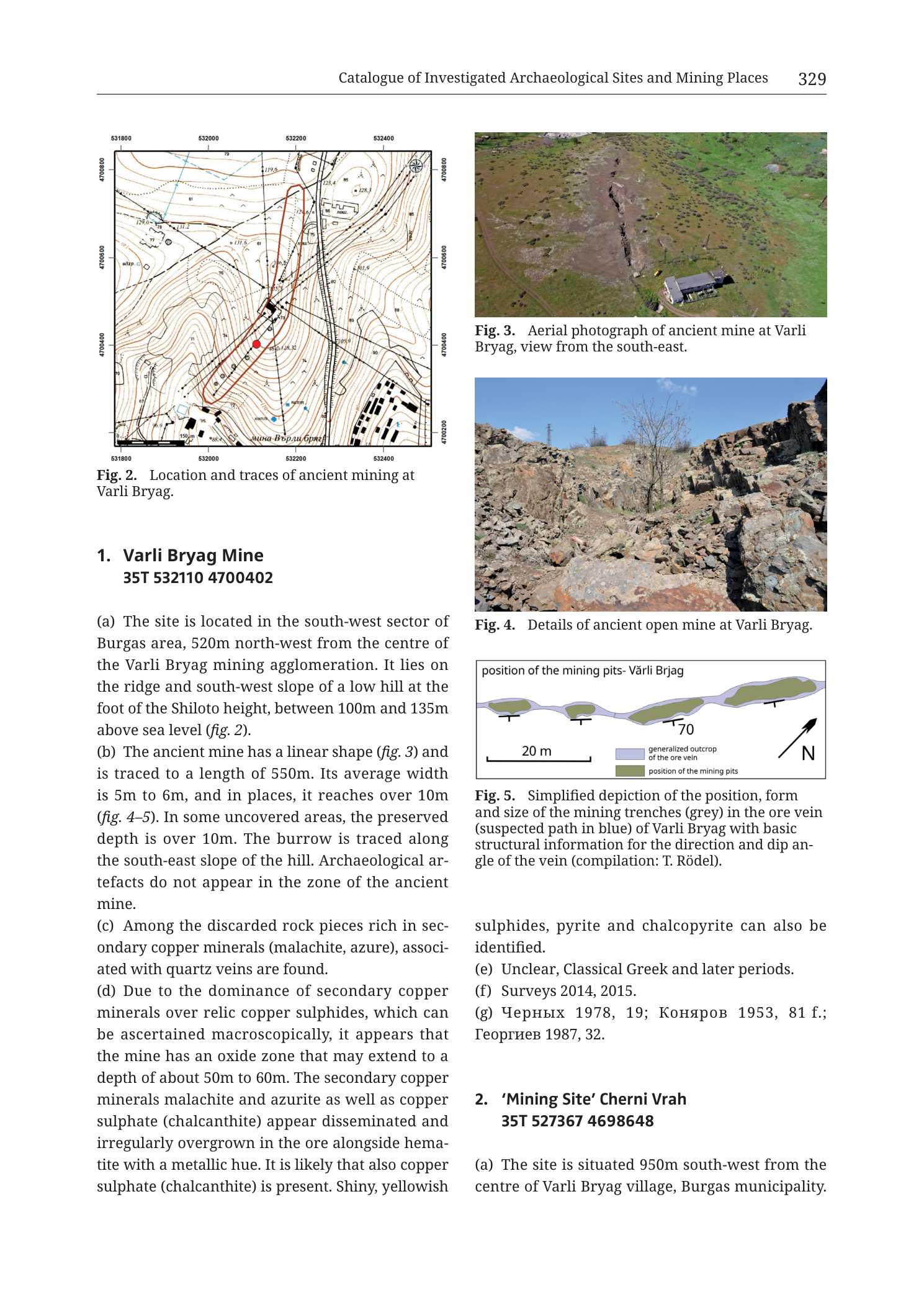
Fig. 2 — Location map (upper-left)
Caption (below map): “Fig. 2. Location and traces of ancient mining at Varli Bryag.”
Coordinate grid labels (UTM-style metre ticks):
- Bottom edge (Easting, left → right): 531800 | 532000 | 532200 | 532400
- Top edge (Easting, left → right): 531800 | 532000 | 532200 | 532400
- Left edge (Northing, top → bottom): 4700800 | 4700600 | 4700400 | 4700200
- Right edge (Northing, top → bottom): 4700800 | 4700600 | 4700400 | 4700200
Map-face labels and annotations (as visible):
- Red filled circle near map centre (site marker) at approximately the intersection of the central grid area.
- Red elongated outline / polygon elongated roughly N–S to NNW–SSE, enclosing a chain of dark rectangular/linear mining-trace symbols running through the centre of the map; the red circle sits inside/near the middle of this red outline.
- Contour elevation labels visible on the map face (brown contour numbers), including among others: 179.5 (NE quadrant), 125.4, 125.1, 131.5, 130.32, 150 (SW), and additional small elevation numerals along ridge/slope contours [some partially small/crowded].
- Place-name label in Cyrillic near south-central area of map, along a track/road line: “мина Върли бряг” (or closely similar orthography as printed).
- Translation: mina Vărli bryag / “Varli Bryag mine”.
- North arrow: simple arrow with “N”, upper-right inside map frame.
- Scale bar: present inside map frame (lower/mid area near south), small bar with numeric ticks [exact metre labels small; bar is a standard topographic inset scale].
- Buildings/structures: clusters of black filled rectangles (building footprints) concentrated in the eastern and north-eastern parts of the map (settlement/industrial fabric of the Varli Bryag mining agglomeration), and sparser structures elsewhere.
- Road/track network: solid and dashed black lines connecting the built-up area to the ridge and mine zone.
- Spot heights and survey points marked with small symbols and elevation numbers across the hill.
Fig. 3 — Aerial photograph (upper-right)
Caption: “Fig. 3. Aerial photograph of ancient mine at Varli Bryag, view from the south-east.”
No text on the photograph itself.
Fig. 4 — Ground photograph (middle-right)
Caption: “Fig. 4. Details of ancient open mine at Varli Bryag.”
No text on the photograph itself.
Fig. 5 — Schematic plan (lower-right, above continuation text)
Title inside figure frame (top): “position of the mining pits- Vărli Brjag”
Legend inside figure (right side of plan):
- ■ (light grey / pale blue-grey fill) — “generalized outcrop of the ore vein”
- ■ (olive / grey-green fill) — “position of the mining pits”
Other annotations on Fig. 5:
- Scale bar (bottom-left of plan): “20 m” with a bar of that labelled length.
- North arrow (right side): shaft with arrowhead labelled “N”, pointing toward upper-right (i.e. plan is not north-up; N is oblique).
- Structural tick/dip annotation: short T-shaped or dip-tick mark on the vein with number “70” (dip angle 70°) adjacent to the central/right portion of the vein outcrop.
- Ore-vein outcrop drawn as a continuous pale elongated ribbon trending roughly left–right across the frame (with a bend); mining pits drawn as a chain of darker elongated lobes superimposed on / along that ribbon (approximately five main pit polygons along strike).
Caption (below Fig. 5): “Fig. 5. Simplified depiction of the position, form and size of the mining trenches (grey) in the ore vein (suspected path in blue) of Varli Bryag with basic structural information for the direction and dip angle of the vein (compilation: T. Rödel).”
Body text — Entry 1 (left column, continuing into right column under Fig. 5)
Heading: “1. Varli Bryag Mine 35T 532110 4700402”
Paragraph (a): “(a) The site is located in the south-west sector of Burgas area, 520m north-west from the centre of the Varli Bryag mining agglomeration. It lies on the ridge and south-west slope of a low hill at the foot of the Shiloto height, between 100m and 135m above sea level (fig. 2).”
Paragraph (b): “(b) The ancient mine has a linear shape (fig. 3) and is traced to a length of 550m. Its average width is 5m to 6m, and in places, it reaches over 10m (fig. 4–5). In some uncovered areas, the preserved depth is over 10m. The burrow is traced along the south-east slope of the hill. Archaeological artefacts do not appear in the zone of the ancient mine.”
Paragraph (c): “(c) Among the discarded rock pieces rich in secondary copper minerals (malachite, azure), associated with quartz veins are found.”
Paragraph (d): “(d) Due to the dominance of secondary copper minerals over relic copper sulphides, which can be ascertained macroscopically, it appears that the mine has an oxide zone that may extend to a depth of about 50m to 60m. The secondary copper minerals malachite and azurite as well as copper sulphate (chalcanthite) appear disseminated and irregularly overgrown in the ore alongside hematite with a metallic hue. It is likely that also copper sulphate (chalcanthite) is present. Shiny, yellowish”
(text continues in right column beneath Fig. 5:)
“sulphides, pyrite and chalcopyrite can also be identified.”
Paragraph (e): “(e) Unclear, Classical Greek and later periods.”
Paragraph (f): “(f) Surveys 2014, 2015.”
Paragraph (g): “(g) Черных 1978, 19; Коняров 1953, 81 f.; Георгиев 1987, 32.”
- Translation (bibliographic surnames): Chernykh 1978, 19; Konyarov 1953, 81 f.; Georgiev 1987, 32.
Body text — Entry 2 (start only; lower-right / continues on next page not in this PNG)
Heading: “2. ‘Mining Site’ Cherni Vrah 35T 527367 4698648”
Paragraph (a) — partial, ends at page break: “(a) The site is situated 950m south-west from the centre of Varli Bryag village, Burgas municipality.”
(Remainder of entry 2 is not on this page image.)
Description
TYPE & PURPOSE
This is a multi-panel catalogue plate page from the site catalogue of Krauss et al. (2020), presenting the full catalogue entry for 1. Varli Bryag Mine and the opening lines of 2. ‘Mining Site’ Cherni Vrah. The page combines:
- a large-scale topographic location map with ancient-mining traces (Fig. 2);
- an oblique aerial photograph of the linear open mine (Fig. 3);
- a ground-level photograph of the open-cast rock face and rubble (Fig. 4);
- a simplified strike-plan of mining pits along the ore vein with dip annotation (Fig. 5);
- structured catalogue prose (fields a–g) for Varli Bryag, plus the start of Cherni Vrah.
Despite the PNG filename referencing Cherni Vrah (catalogue no. 2), the printed page content is dominated by Varli Bryag (catalogue no. 1); Cherni Vrah only begins at the bottom. Purpose: document location, morphology, mineralogy, dating, survey history, and bibliography of the Varli Bryag ancient mine within the Burgas / Medni Rid research area.
OVERALL PAGE LAYOUT
- Portrait full-page render, two-column academic layout.
- Left column top: Fig. 2 (square topographic map).
- Left column below map: Fig. 2 caption; then heading and body (a)–(d) of entry 1 (text of (d) mid-sentence at column break).
- Right column top → bottom: Fig. 3 + caption; Fig. 4 + caption; Fig. 5 + caption; continuation of entry-1 text from mid-(d) through (e)(f)(g); then heading and (a) start of entry 2.
- Running header identifies the chapter as the catalogue of investigated archaeological sites and mining places; printed page 329.
Fig. 2 — LOCATION / TOPOGRAPHIC MAP
Type & purpose. Large-scale topographic site map showing contour relief, modern built fabric, roads/tracks, and the mapped traces of ancient mining at Varli Bryag, with a red site centroid and a red outline enclosing the principal mine-trace corridor.
Frame, extent, orientation.
- Nearly square map frame.
- North arrow in the upper-right of the frame; north is up.
- Coordinate ticks on all four sides in metre units (UTM easting / northing style).
- Geographic setting: SW sector of the Burgas area, at the Varli Bryag mining agglomeration, on a low hill at the foot of Shiloto height (per body text).
Scale.
- A small graphical scale bar is present inside the map frame (south-central / lower area).
- No printed ratio scale (e.g. 1:5 000) is legible on this render.
- From grid ticks: easting span 531800–532400 = 600 m; northing span 4700200–4700800 = 600 m. The map therefore covers a ~600 m × ~600 m ground window.
Coordinates / grid.
- Easting labels: 531800, 532000, 532200, 532400 (100 m grid spacing).
- Northing labels: 4700800, 4700600, 4700400, 4700200 (200 m labelled spacing on the frame; intermediate grid lines are present at finer interval on the face).
- No zone prefix printed on the map face itself; zone is given in the catalogue heading as 35T.
Relief & physiography.
- Brown topographic contours with numbered elevation labels. Contours define a low hill / ridge system: higher ground toward the north and centre-north (labels in the ~125–180 m range visible, including 179.5 in the NE), sloping down toward south and southwest.
- Body text states the site lies between 100 m and 135 m a.s.l. on the ridge and SW slope of a low hill at the foot of Shiloto height — consistent with the contour field around the central red marker.
- Contour density is moderate to tight on the hill flanks, looser on gentler ground near the built-up east side.
Hydrography & coast.
- No coastline on this local map.
- No named rivers; drainage is only implied by contour re-entrants (valley forms) if present as unlabelled contour embayments.
Anthropogenic / cultural features.
- Dense cluster of black building footprints in the eastern half of the map — the Varli Bryag mining agglomeration / settlement fabric.
- Road and track lines link the built-up zone westward/northwestward onto the hill and mine corridor.
- Ancient mining traces: numerous dark linear and rectangular symbols (trenches, pits, spoil edges) aligned in a elongated N–S to NNW–SSE belt through the map centre, enclosed by a hand-drawn red outline polygon.
- Red filled circle = catalogue site point (centroid of entry 1).
- Cyrillic label “мина Върли бряг” near a southern track approaches the mine area from the built zone.
Geological content on Fig. 2.
- This panel is topographic / archaeological-trace, not a coloured geological map. No lithological fill units, no stratigraphic legend, no keyed fault symbols.
- Ore-vein geology is not mapped here; it is addressed in Fig. 5 and in the mineralogical prose of (c)–(d).
Spatial relationships (Fig. 2).
- The ancient mine corridor (red outline + dark trench symbols) occupies the ridge/upper SW slope zone west of the main building cluster.
- The red centroid sits inside the mine-trace belt, slightly west of map centre, consistent with body text “520 m north-west from the centre of the Varli Bryag mining agglomeration.”
- Built fabric is concentrated east of the mine belt; the mine itself is not under modern dense housing on this map.
Fig. 3 — AERIAL PHOTOGRAPH
- Oblique aerial colour photograph looking across a grassy / low-vegetation hillside.
- View direction stated in caption: from the south-east.
- A long, dark, roughly linear open excavation / trench scar runs across the upper slope (the ancient open mine), contrasting with green vegetation on either side.
- A modern light-coloured rectangular building (single-storey, pale roof/walls) sits on the lower-right portion of the slope below the trench line.
- Scattered bushes and irregular ground surface; no people or scale objects other than the building.
- Illustrates the linear plan shape claimed in paragraph (b) and ties the map traces to real terrain.
Fig. 4 — GROUND PHOTOGRAPH
- Ground-level colour photograph of the ancient open mine interior / wall.
- Shows broken, blocky bedrock and rubble of dark grey to brown rock, with a steep irregular face and loose boulders in the foreground.
- Sparse leafless shrub/tree rising from the cut; blue sky with light cloud above.
- Illuminated by clear daylight; rough texture of jointed/fractured host rock and collapsed blocks is the dominant visual content.
- Supports paragraph (b) statements on width and preserved depth of the open cut, and provides macroscopic context for the secondary-copper mineral observations in (c)–(d).
Fig. 5 — SIMPLIFIED MINING-PIT / VEIN PLAN
Type & purpose. Schematic plan view of the ore-vein outcrop and the chain of mining pits/trenches along it, with a single structural dip measurement and orientation.
Frame, orientation, scale.
- Horizontal rectangular panel.
- North arrow points toward the upper-right corner of the panel — the plan is rotated relative to geographic north (long axis of the vein is drawn left–right on the page but is not an E–W geographic line).
- Scale bar: 20 m.
Content.
- Pale ribbon = generalized outcrop of the ore vein (legend: light grey/blue-grey; caption also says “suspected path in blue”).
- Darker olive/grey-green lobes = position of the mining pits — a longitudinal chain of about five coalesced elongated pit polygons strung along the vein, matching the “linear shape” and multi-segment trench morphology.
- Dip annotation “70” with a dip-tick on the vein indicates a steep dip of 70°.
- No contouring, no buildings, no coordinates on this schematic.
Spatial / structural reading.
- Mining pits are confined to the vein outcrop corridor rather than scattered off-vein — i.e. extraction followed the ore structure.
- Steep 70° dip explains deep narrow open-cut morphology (body text: average width 5–6 m, locally >10 m; preserved depth >10 m in places; oxide zone inferred to 50–60 m).
- Length scale: the drawn pit chain spans several times the 20 m bar (visual order consistent with a long working; full 550 m length stated in text may extend beyond the portion drawn, or the schematic summarizes the main pit train).
CATALOGUE ENTRY 1 — VARLI BRYAG MINE (structured fields)
Catalogue convention on this page uses lettered fields:
- (a) Location / setting: SW Burgas sector; 520 m NW of Varli Bryag mining-agglomeration centre; ridge and SW slope of low hill at foot of Shiloto height; 100–135 m a.s.l.; cross-ref fig. 2. Centroid printed: 35T 532110 4700402.
- (b) Morphology: linear ancient mine, traced length 550 m; average width 5–6 m, locally >10 m; preserved depth >10 m in uncovered areas; burrow traced along SE slope of the hill; no archaeological artefacts in the mine zone; cross-refs figs. 3, 4–5.
- (c) Finds / waste mineralogy: discarded rock pieces rich in secondary copper minerals (malachite, azure [azurite]) associated with quartz veins.
- (d) Ore / alteration character: secondary Cu minerals dominate over relic Cu sulphides (macroscopic); oxide zone inferred ~50–60 m deep; malachite, azurite, copper sulphate (chalcanthite) disseminated/irregularly overgrown with metallic-hue hematite; shiny yellowish sulphides, pyrite and chalcopyrite also identifiable.
- (e) Dating: “Unclear, Classical Greek and later periods.”
- (f) Fieldwork: Surveys 2014, 2015.
- (g) Bibliography: Черных 1978, 19; Коняров 1953, 81 f.; Георгиев 1987, 32.
CATALOGUE ENTRY 2 — START ONLY
- Heading: 2. ‘Mining Site’ Cherni Vrah
- Centroid: 35T 527367 4698648
- (a) begins: site situated 950 m SW from the centre of Varli Bryag village, Burgas municipality.
- No figures for Cherni Vrah appear on this page; entry continues on the following page (not in this PNG).
SPATIAL RELATIONSHIPS (PAGE-LEVEL)
- Varli Bryag Mine is a long, steeply dipping (70°), NW–SE to N–S-trending open-cast working excavated on a secondary-copper-rich quartz vein on a low hill west/northwest of the modern Varli Bryag mining settlement fabric.
- Map window (~600 × 600 m) places the mine immediately west of dense building footprints and connects them by tracks.
- Cherni Vrah (entry 2) is introduced as a separate site 950 m SW of Varli Bryag village centre, with a different UTM centroid (easting ~527367 vs Varli Bryag ~532110) — i.e. several kilometres west of the Varli Bryag mine map window, not inside Fig. 2.
- Mineralogical emphasis on malachite/azurite/chalcanthite over primary sulphides frames Varli Bryag as an oxide-zone ancient working, relevant to the broader Medni Rid / Rosen secondary-copper and archaeometallurgy theme of the volume.
RELATIONSHIP TO OTHER FIGURES
- Internal cross-references: body (a)→fig. 2; (b)→fig. 3 and figs. 4–5.
- Fig. 5 compiled by T. Rödel (credited in caption).
- Filename ties the PNG to catalogue item n02 Cherni Vrah, but the rendered page is the Varli Bryag plate plus only the opening of Cherni Vrah — Cherni Vrah’s own map/photos are expected on the next catalogue page(s), not here.
- Companion regional context for both sites lies elsewhere in the Tübingen volume (regional maps, Medni Rid overview plates).
Consistency Check
- Centroid (entry 1, body heading): 35T 532110 4700402
- Map bounds (Fig. 2 axis labels): Easting [531800–532400], Northing [4700200–4700800]
- Easting check: 531800 ≤ 532110 ≤ 532400 → PASS
- Northing check: 4700200 ≤ 4700402 ≤ 4700800 → PASS
- Result: PASS
- Note: Entry 2 centroid 35T 527367 4698648 is outside Fig. 2 by design (different site); no map on this page applies to entry 2.
Notes
- Filename
Cat_p331_n02_Cherni_Vrah_mining_site.pngvs printed content: the page is primarily catalogue entry 1 Varli Bryag Mine (with Figs. 2–5); entry 2 Cherni Vrah only starts. Printed page number in the header is 329, while the filename encodes p331 — likely a PDF-page vs book-page offset (book-page = PDF-page − 2 is a known convention in this collection) or a filename rounding; the authoritative printed page on the image is 329. - Contour elevation numerals on Fig. 2 are small; listed values are those clearly readable (179.5, 125.4, 125.1, 131.5, 130.32, 150, etc.). Additional crowded spot heights exist but are not all individually legible at this render resolution.
- Fig. 2 scale-bar numeric labels are small; ground extent is securely constrained by the 600 m × 600 m grid window instead.
- Fig. 5 caption says mining trenches “(grey)” and ore-vein path “(suspected path in blue)” while the in-figure legend uses pale fill for the vein and olive for pits — colour wording in caption vs legend fill is slightly inconsistent; both describe the same two-class plan.
- Orthography variants as printed: “Varli Bryag” (body/captions), “Vărli Brjag” (Fig. 5 title), Cyrillic “Върли бряг” on the map — same toponym.
- “azure” in (c) is the text’s wording for azurite-type secondary copper carbonate.
- Entry 2 is truncated mid-entry at the page break; do not infer further Cherni Vrah content from this image alone.
- Consistency check applies to entry 1 / Fig. 2 only; it passes cleanly on both axes within valid SE-Bulgaria UTM 35T ranges.